| Start | Schaidasattel (1068m) |
| Valley base | Bad Eisenkappel |
| Distance | 5km (one way) |
| Height gain | 1071m |
| Grade | 2 |
| Time | 3hrs (+ 2hrs return) |
| Location | West of Bad Eisenkappel |
Standing north of the main Karawanken ridge, Hochobir is the fourth highest in the range and has long been adopted as the local ‘house mountain’ of Bad Eisenkappel. The Bad Eisenkappeler Hut sits at the head of a road 580m below and to the east of the peak, and it is from this hut that the ascent is usually made. Our route, however, is rather more varied and interesting.
The Schaidasattel, where our route begins, is a road pass linking Bad Eisenkappel with the Zell communities. The road to take is clearly signed from the northern end of the village, plunging at once into the narrow, wooded Ebriach valley. A little over 2km later, you may notice a side road which branches off to the Bad Eisenkappeler Hut. In another 4km a second road branches off. The so-called Hochobir Hochalpenstrasse, this too goes to the Bad Eisenkappeler Hut, while the Schaidasattel road becomes more sinuous on the final climb to the pass. A few parking spaces are found here, with very fine views over the Zell valley and the frontier mountains.


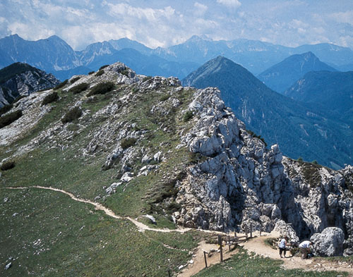
Limestone ridge below Hochobir
On the north side of the road at the Schaidasattel walk up a broad path/track leading into forest. Very shortly a sign directs you onto a footpath (the Simon-Rieger-Weg) climbing roughly northeast, crossing and recrossing a forest track until you emerge from the trees near the subsidiary peak of the Kuhberg, to gain lovely views south.
Come to a saddle below the Kuhberg, from where you should be able to see the Freibach reservoir below to the northwest, beyond that to the Drau, and even farther away to Klagenfurt in the low-lying country north of the Drau.
The path now skirts the east side of the ridge linking Hochobir with the Kuhberg, and works its way up flowery slopes to gain a point where you look down on some rugged limestone formations. Here the ridge plunges into a seemingly bottomless valley on its west side. Join a broad path coming from the right. This is the standard route of ascent from the Bad Eisenkappeler Hut, and you now head north along it for the final climb to the summit of Hochobir (2139m), which is topped by a large cross.
Note A longer alternative route back to the Schaidasattel descends to the Bad Eisenkappeler Hut in 45mins or so, then takes a varied route along footpaths and tracks used by the Karawanken Wanderweg. The route is well signed and waymarked, and it brings you onto the road a few paces from the Schaidasattel in a little under 2½hrs from the hut – allow 3hrs from the Hochobir summit.
In the late 19th century an observatory and meteorological station stood on the summit of Hochobir, and a few remains can still be found there. It has a wonderful panoramic view which encompasses a vast sweep of country to the north, the final modest heights of the Karawanken to the east, the Carnic Alps away to the west, the impressive frontier wall to the south, and beyond that the mountains of Slovenia culminating in the summit of Triglav, highest in the Julian Alps, peering above ridges to the westsouthwest.
