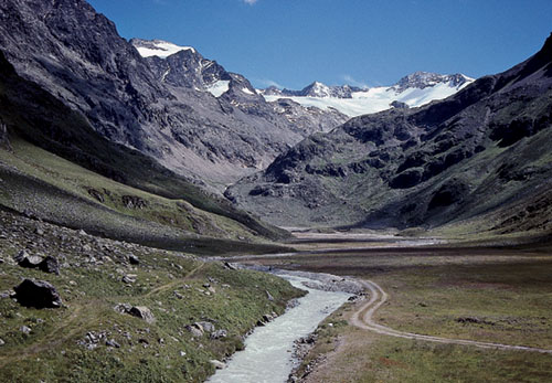
Meadows of the upper Sulztal, seen from the Amberger Hut
| Start | Gries-im-Sulztal (1569m) |
| Valley base | Längenfeld or Gries |
| Distance | 6km (one way) |
| Height gain | 567m |
| Grade | 2 |
| Time | 2hrs (+ 1½hrs return) |
| Location | Southeast of Gries |
The Amberger Hut overlooks such an idyllic scene that this walk would be worthwhile even if the rest of the valley held little of interest. But the Sulztal is delightful throughout its length, which compensates for the fact that this hut approach follows a dirt road all the way.
Walk through Gries heading upvalley, passing the car park at the eastern end of the village. The paved road soon become a dirt road, at first on the north side of the river, then crossing to the south side and twisting uphill through woodland. For some way views are restricted, but now and again a gap in the trees reveals the unmistakable pointed 3497m Schrankogel directly ahead. About 12mins after crossing the river, the road forks – the right branch goes to Nisslalm and the Schönrinnen See – but we continue ahead in the direction of the Sulztalalm.

Meadows of the upper Sulztal, seen from the Amberger Hut
About 1hr 15mins from Gries, the path comes to Vorderer Sulztalalm (1915m, refreshments) where a sign gives 45mins to the Amberger Hut. The way rises at a steady angle, then curves through a narrowing gap to emerge to the secluded meadows of Hinterer Sulztalalm (2085m).
The dirt road eases through the meadows, crosses the river for the last time, then angles above a minor gorge before turning rocks for a final short rise to the Amberger Hut.
The Amberger Hut (2136m) overlooks a vast meadowland sliced by the Fischbach which flows directly from the Sulztalferner, the valley’s most important glacier hanging from the Windacher Daunkogel. The Category I hut has 10 beds and 59 dormitory places, and is fully staffed from early February to the end of April, and from mid-June to the beginning of October (tel 05253 5605).
The valley is hidden from the Ötztal into which it drains at Umhausen, but as you take the winding access road through forest above the village, so the impressive Stuibenfall may be seen thundering over a sudden drop. Accessible from the road, the granite Tauferberg is a popular local klettergarten with routes of 10–30m. The paved road ends at the tiny village of Niederthai (1535m) which has a handful of hotels, gasthöfe and holiday apartments. Beyond the village the valley reaches northeastward into a lovely mountain landscape, not as dramatic perhaps as some other Stubai districts, but it’s undeniably seductive to the walker.
Above and to the east of Oetz the Nedertal and Sellraintal, linked by the resort village of Kühtai, effectively define the northern limits of the Stubai Alps. Drained by the Nederbach, the Nedertal is narrow and heavily forested, but on the approach to Kühtai it opens out, the woodland cover is less constricting and three tributary valleys cut into the south flanking mountains: Wörgetal, Mittertal, and Längental. The last of these has a reservoir at its entrance beside which the road from Oetz makes its final approach to Kühtai at 2017m. Since Kühtai is primarily a ski resort, it has a number of cableways on slopes to north and south, and a distinctly out-of-season atmosphere in summer. Above and to the south lies a second reservoir, the Speicher Finstertal, and alongside it a trail entices into less-managed country. There are, in fact, several opportunities to explore the high country south of the Nedertal, among them a series of waymarked paths promoted locally as the Knappenweg – usually starting at the Bergstation Hochoetz (2020m) reached by the Acherkogelbahn cable-car from Oetz. There are, of course, plenty of other paths, tracks and cairned routes worth following.