| Start | Ramsau (Sonnalm: 1350m) |
| Distance | 9km |
| Height gain | 423m |
| Height loss | 1140m |
| Grade | 2 |
| Time | 3–4hrs |
| Location | North of Mayrhofen, then south along the east flank of the Zillertal |
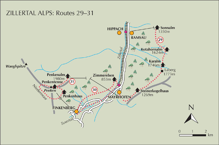
Ramsau and Hippach face one another across the Ziller about 4km north of Mayrhofen. In the winter, skiing takes place on the slopes above Ramsau on the valley’s east flank, and in summer the Ramsberglift carries visitors up to the restaurant of Sonnalm, from where a series of tracks and footpaths can be linked to make a pleasant high walk among pastures, groups of alm buildings and steep forest on the way to Mayrhofen. Refreshments can be had at Sonnalm, Kotahornalm and Karalm.

Walkers based in Mayrhofen can take the train or bus to Hippach-Ramsau, or follow an easy footpath alongside the river. From Ramsau take the chairlift (Ramsberglift) to Sonnalm, then descend a few paces onto a dirt road and head south (direction Kotahorn). Rising easily the way takes you past a few farms between steep meadows. At a hairpin leave the dirt road and walk ahead on a footpath which zigzags uphill among trees, then angles south again. When it forks take the upper path which brings you to a grass track in a clearing. Red waymarks take you above this on a continuing path. This leads to another crossing track just beyond the rustic 400-year-old building of Kotahornalm (1624m, refreshments).
Walk alongside the alm building on a narrow path which soon climbs once more and turns a spur to a view of the Karalm ahead. The path leads directly to it. Karalm (1746m, refreshments) occupies a steeply sloping pasture and is reached about 30mins from Kotahornalm.
The way continues round the hillside and rises a little further to reach more alm buildings at Laberg (1773m). It is here that you take a grass path heading to the right and wander downhill to pass a whole string of attractive alm buildings before entering forest. Signs are for Brandberg and Mayrhofen, and after twice crossing a track, you come in view of the Steinerkogelhaus (1269m). Immediately to its left a path winds down to more forest, and at a sharp bend you gain a very fine birdseye view onto Mayrhofen and up the Tuxertal.
Descend through steep forest on countless zigzags, pass a tiny chapel and religious carvings that represent the stations of the cross, and eventually come onto a minor road near Mayrhofen’s cemetery.