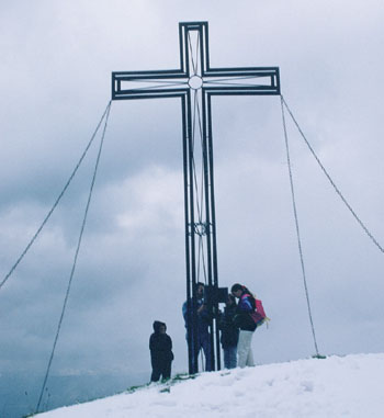
The 1886m Guggenkogel summit covered with summer snow
| Start | Westendorf (783m) |
| Distance | 17km |
| Height gain | 1103m |
| Height loss | 1103m |
| Grade | 3 |
| Time | 6½–7hrs |
| Location | Southeast of Westendorf |
Nachsöllberg, Westendorf’s ‘home mountain’, is usually ascended by the Alpenrosenbahn gondola lift. The following route is for keen walkers who may wish to climb it on foot. There’s nothing difficult about it, but with a tour of the upper mountainside, it makes for a fairly long and strenuous day out. There are plenty of opportunities for refreshment, and a good choice of lunch spots with fine views, while the descent is on a trail that visits several waterfalls. The walk could always be cut short if needed, by descending via the gondola lift.
Take the narrow road which passes to the right of the tourist office (as on Route 41). At the top of the slope bear right for a short distance, still on the road, then take a path on the left signed to Zieplhof and Nachsöllberg. Climbing through forest, about 30mins from the tourist office come to the Jausenstation Zieplhof (970m, refreshments).
Walk up the road until it ends by a house, and go ahead on the continuing track until a footpath breaks to the right. This is the Wanderweg Nachsöllberg which takes you into forest again. Blue waymarks are your guide when the path forks, and following these you continue a steady ascent. Leaving forest, the way crosses open grass slopes, passes beneath the gondola lift, and brings you to the farm of Ellmerer. Pass along the right-hand side of the house, then up a fence-enclosed footpath to another stretch of forest. There are alternative crossing tracks, but blue waymarks sign the correct route.
Out of the forest once more you cross another meadow and come to Gasthof Stimmlach (1½hrs, refreshments). Wander up the road as far as Gasthof Maierhof (refreshments), then take a signed path climbing to the right, heading for the Alpenrose Hut. Winding through forest and steep open slopes, about 2¼–2½hrs from Westendorf you arrive at the Alpenrose Hut (1534m, refreshments) which enjoys views across the valley to the Höhe Salve.
The Category II Alpenrose Hut belongs to the Schorndorf section of the DAV. With 20 beds and 40 dormitory places it is manned all year except in November and from mid-April to mid-May (tel 05334 6488).
A few paces beyond the hut take a red-and-white waymarked path climbing to the right. This soon becomes a track or piste which you follow winding up the hillside, eventually reaching the Talkaser restaurant (refreshments) and the top station of the Alpenrosenbahn gondola lift at 1760m.

The 1886m Guggenkogel summit covered with summer snow
Bear left and take the panoramaweg, a narrow path at first skirting trees to edge the eastern slopes of the Nachsöllberg peak whose summit is known as the Guggenkögele, with views steeply down into the Brixenbachgraben valley. Soon leave the trees and twist up to the large summit cross of the Guggenkögele at 1886m (3–3¼hrs).
Continue heading north over the summit down to a tiny chapel nestling on the ridge near the top station of the Choralmlift. Turn sharp left onto a track which leads back to the gondola station and Talkaser restaurant. Passing the restaurant on your right head south along the broad track towards Fleidingalm, descending gently to the saddle of the Höhningerscharte (1723m) and a junction of tracks. Take the left-hand path to make a contour overlooking the head of the Brixenbachgraben valley, and about 20mins later come to a path junction at the Einködlscharte (1700m).
Keep ahead for a few paces, then branch right for Fleidingalm. The trail slopes down to a crossing track above the Windauberg Hochalm. Turn right and follow the track as it curves round the southern flank of the Fleiding. Just before coming to the Fleidingalm restaurant (refreshments) by a ski tow, turn left down another track and follow this until, at a left-hand hairpin, a minor track breaks directly ahead signed Wasserfallweg and Westendorf.
When this track forks take the lower branch, but you later leave this on the contining Wasserfallweg footpath which cuts to the right, crosses the hillside, goes through a strip of forest and emerges to a lovely view of Höhe Salve ahead, and Westendorf in the valley below. Descending to forest once more join another path, cross a stream and come to the very tiny wooden chapel at Hampferalm.
The way now climbs above the three alm buildings, enters forest yet again, and crosses a series of waterfalls, the last of which is glimpsed through the trees before you actually reach it. Emerging from forest the trail descends to a narrow road where you turn right and walk uphill. After crossing a bridge come to a junction of roads just below Gasthof Maierhof (refreshments) and turn left, now on the familiar route used earlier for the ascent. Follow this down to Gasthof Stimmlach (refreshments) and turn right to retrace the route back to Westendorf.