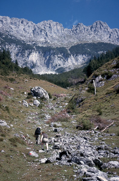
Above Scheffau a link path leads to the Wilder-Kaiser-Steig
| Start | Scheffau (744m) |
| Distance | 14km |
| Height gain | 726m |
| Height loss | 668m |
| Grade | 3 |
| Time | 5hrs |
| Location | North and northeast of Scheffau |
The Wilder-Kaiser-Steig is a long waymarked trail which runs along the south flank of the Wilder Kaiser from Kirchdorf (or St Johann in Tirol) to Kufstein, a journey of around 35km (see Route 68). This central section of the route makes a rewarding day’s exercise, giving a near-circular walk with a variety of scenery: soaring rock slabs, the chaos of scree chutes, trim forest, and rough pastureland. There’s also a strong possibility of sighting chamois along the way.
From Scheffau village square walk up the road in the direction of the Hintersteiner See; when it makes a sharp left-hand bend, go ahead on a footpath leading to a narrow service road at Leitenhof. Maintain direction, but when the road curves towards a farm, take a footpath signed to Kaiser Hochalm, Schiessling and Hintersteiner See.
This charming forest path rises through the Gaisgraben valley, and about 30mins from Scheffau brings you onto another narrow road at 911m. Turn left, and 1min later break away on a track going ahead, rising to a house. Bear right on a track which you follow all the way to the Steiner Niederalm (1087m, 1hr).
Passing the alm house follow a narrow trail waymarked with red flashes, climbing the steep hillside for another 15–20mins to a path junction. Turn right along the Wilder-Kaiser-Steig – although there’s no indication here that this is the WKS path, other than yellow-and-black waymarks.

Above Scheffau a link path leads to the Wilder-Kaiser-Steig
After rising over somewhat rough ground, the path enters beechwoods, from which you eventually emerge to be confronted by a scene of wild, ragged mountains ahead and above, but a pleasant green and pastoral valley below. Approaching the alm buildings of Kaiser Hochalm the path contours, then crosses a slope ablaze with alpenroses in early summer, before rising to the alm. This is gained about 1¾–2hrs after leaving Scheffau. Pass the three buildings at 1417m and continue up the slope ahead.
After gaining a high point of 1470m, the way descends a short, steep pitch on hewn-out steps with a fixed cable serving as a handrail. Thereafter the trail heads towards screes and comes to a path junction at 1409m, where the left-hand option makes the ascent of the 2304m Treffauer. Continue down among trees to another junction and, ignoring the right branch, keep ahead.
Cross the southern flank of the Tuxeck where a scree slope is being invaded by a mass of dwarf pine. The path eases through, fringed with heather and horizontal layers of juniper, with glorious views across the valley to the right to the rolling hills of the Kitzbüheler Alps.
Shortly after passing another footpath branching left to climb the Tuxeck, the trail forks in woodland. The left branch goes directly to the Grutten Hut, but we take the right branch and descend through forest to a major track. Bear right and wind downhill to the Riedl Hut (1268m, 3½hrs; accommodation and refreshments).
Note The altitude of the Riedl Hut is variously quoted on maps as 1268m, 1230m and even 1224m; the height quoted here is taken from the official hut book.
Immediately beyond the hut take a footpath cutting left. This soon brings you onto a plateau above the Biedringeralm where you bear left along a track. Follow this down to Gasthof Riesen (951m), beyond which a road continues to Ellmau via Wimm.
Note Should you need to return to Scheffau, there is a linking bus service from Ellmau, although some services do not go into the village itself, but drop passengers off at the Wilder Kaiser Gasthof on the main road below Scheffau Dorf.