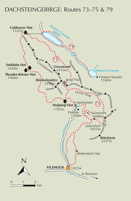
Filzmoos is arguably the finest base for a walking holiday on the south side of the Dachsteingebirge. The Hinterwinkl valley stretching behind the village gives access to the Gosaukamm, the Gosauer Stein and, via the Sulzenhals saddle, the great Dachsteinsüdwand (south face). A toll road, served by the Filzmooser Wanderbus, goes as far as Hofalm in the Hinterwinkl, and it is from there that some of the best walks begin.
| Start | Filzmoos (Hofalm: 1268m) |
| Distance | 14km |
| Height gain | 712m |
| Height loss | 923m |
| Grade | 3 |
| Time | 4½–5hrs |
| Location | North of Filzmoos |
On this splendid near-circular walk both the Bischofsmütze and the impressive rock scenery at the head of the valley, north of Filzmoos, are seen at close quarters. It’s a reasonably strenuous walk which visits a mountain hut and an attractive alm where refreshments can be had, and views are lovely throughout.

Take the bus, or drive upvalley from Filzmoos to Hofalm. Pass alongside the alm building, then cross two footbridges on the left which carry a footpath the short distance to Unterhofalm. Walk past the stables, then take path no 612 on the right, signed to the Hofpürgl Hut. After crossing a stony streambed, the way rises across grass slopes, then steepens, twisting uphill to dwarf pine and alpenroses. In 50mins or so it comes to a path junction a little north of the Hofpürgl Hut (1705m, accommodation and refreshments), a large building perched upon a grassy ridge.

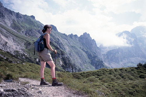
The Linzer Weg above Hofalm
Unless you need to visit the hut turn right along the Linzer Weg (now path no 601/612), which crosses the Kesselwand below the Bischofsmütze. The route takes you over screes, then up and over a spur with dwarf pine and more alpenroses leading to another path junction. The upper trail (612) climbs to the Steigl Pass, but we take the lower option curving right across the valley head; an interesting, ever-varied route with a persistant rise and fall.
About 1hr 50mins from the start arrive at another path junction (Untere Rinderfeld) where the right branch returns to Hofalm via the little Almsee tarn. Ignoring this option, cross the pasture before climbing to a higher pastureland. A signpost marks yet another junction (Rinderfeld), where the left branch climbs to the Reissgangscharte and, beyond it, to the Adamek Hut, while we veer right in the direction of the Rettenstein (Rötelstein) and Sulzenhof.
Crossing the pasture the path then rises to a high point and a row of trees, beyond which you descend among rocks and alpenroses. Thereafter pick a way up and over a series of minor ridge spurs above a steep little hanging valley, eventually climbing to gain a major ridge spur, the Sulzenchied, in 3hrs. The path swings left, rises a little further to a shoulder at about 1975m (a cross can be seen to the left), then descends steeply to the saddle of Sulzenhals (1825m), which is almost completely covered with dwarf pine. On the south side rises the 2247m Rötelstein.
Turn right through a fence, and wander among dwarf pine, then down to a lovely stand of larches before easing across a pastureland slope, once again looking ahead to the majestic Bischofsmütze. Sulzenalm (also known as the Wallehen Hut, 1608m, accommodation and refreshments) is reached about 20mins from the Sulzenhals saddle, and makes a fine place to relax with a drink.
The Wallehen Hut is variously shown on maps as 1608m or 1590m, while some local literature gives the altitude as low as 1534m. It has 6 beds and 14 dormitory places, and is open both winter and summer (tel 06453 8289).
From here a dirt road descends to the valley. At first a path drops below the road, then crosses to a second alm building. The way now cuts left of the road, and is signed to Filzmoos. Wander across more fine pastureland dotted with limestone rocks, then into forest where the path becomes a track. In a little over 4hrs, still in forest, take path no 638 which cuts to the right away from the track. Descending among trees come down to a dirt road, and after turning the first hairpin, take the continuing path down to the left, coming to another dirt road which you follow briefly to the left. Soon, with houses seen ahead, take the footpath alternative which breaks to the right alongside trees and through more forest to a metalled road. Shortly after this join the main valley road near the toll booth for traffic going to Hofalm, and follow this down to Filzmoos.