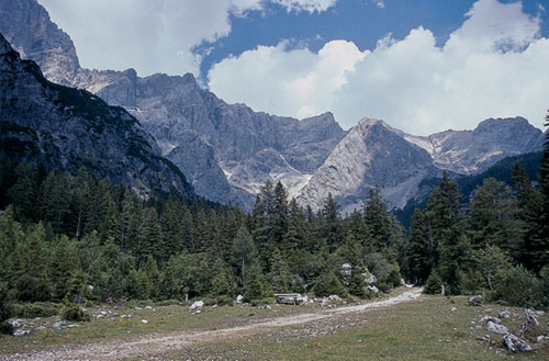
Six kilometres east of Filzmoos, the road leading to Ramsau am Dachstein makes a sharp right-hand hairpin at the entrance to a charming valley immediately below the Dachstein’s south face. This valley is wooded in its lower regions, but rough pastures spread from the upper tree level to the vast scree fans that spill from the face of the mountains. A private road (partly unsurfaced) winds up into this valley, and 4km from its entrance, ends at the Bachlalm. In summer the Filzmooser Wanderbus runs a direct service here about three times a day, but a much more frequent shuttle minibus service operates along the private road to Bachlalm every 30mins from 8am to 4.30pm. For visitors with their own transport, there’s plenty of parking space near the start of this road.
Useful as a base for a variety of walks and climbs, Bachlalm has 16 beds and 32 dormitory places, and is open from May to October (tel 03687 81439).
| Start | Bachlalm (1495m) |
| Distance | 12km |
| Height gain | 915m |
| Height loss | 915m |
| Grade | 3 |
| Time | 4½–5hrs |
| Location | North of Bachlalm |
This scenically varied and rewarding walk makes an elongated circuit among woodland, pasture and scree. In places it’s rough underfoot and shadeless, and on a bright summer’s day the sun often reflects its heat from the bleached limestone to create a furnace-like atmosphere – make sure you carry plenty of liquids with you. Although much of the route leads across what might at first seem to be barren rock and scree, there’s a surprising amount of vegetation, with many alpine flowers to brighten the way. Refreshments are available at the Dachstein-Südwand Hut, about 3hrs after setting out.

Descend a short distance down the track from Bachlalm, then branch left when it forks. Rising gently the now stony track is flanked for a while by larches, but in 30mins you emerge from these into the valley’s upper pastures where there’s a signed junction. Fork right on a narrow path which soon twists among dwarf pine through which you come to the base of a large scree tumbling from the Windleger Spitze.
At first you go up the left-hand side of this scree, before picking a way up the centre to gain another belt of dwarf pine that effectively divides the scree into two sections. On the edge of this dwarf pine there’s another path junction where you continue ahead for another 10mins across the next scree, to yet another junction marked this time on rocks. It is here that a route to the Adamek Hut via the Windleger Scharte breaks away to the left. Ignore this option and keep ahead to rise through a rocky cauldron of a hanging valley between the Torstein on the left and Raucheck on the right. At its head the U-shaped col of Tor (2033m) is gained about 1½hrs from Bachlalm.
Descend steeply on the eastern side, at first down rocks, then scree, at the foot of which you come to a rocky basin with a small ‘island’ of grass. Abundant waymarks guide a way through a wilderness of stone, on the far side of which you cross a low ridge of grass and dwarf pine to gain a view of the Dachstein-Südwand Hut ahead, set upon a spur reached by a trail rising across yet more screes.

The Bachlalm trail below the Dachstein south face
The way descends again, then rises in a long slant to be joined about 10mins below the hut by a path which will be used on the return to Bachlalm. The privately owned Dachstein-Südwand Hut (1871m, accommodation and refreshments) is reached about 3hrs from Bachlalm. Since it can be reached in just 30mins from the Türlwand roadhead, it is invariably busy on fine summer days, but it makes a perfect lunch stop, with tremendous views from the terrace.
Descend the same path used on the approach as far as the junction where a sign indicates the way to Bachlalm in 1hr 45mins. Take this left branch which goes steeply down to pastureland, then steep larch-clad slopes that eventually bring you into an idyllic pasture, about 50mins from the hut, where a track cuts left to the Austria Hut.
This pasture at the foot of the Dachstein’s bold south face, is almost like a small parkland, with rocks and stands of larch, flowers in the grass, and a clear stream easing through a bed of white stones. Perfection!
Ignore the track and continue ahead on the left bank of the stream, soon arriving at a footbridge (Martinsbrücke) at a confluence of streams. Over the bridge follow a track downvalley, eventually coming to the dirt road below Scharlalm. Turn right and wander up the road for another 10mins or so to arrive back where you began at Bachlalm.

Pastureland trail junction below the Sulzenhals (Route 77)