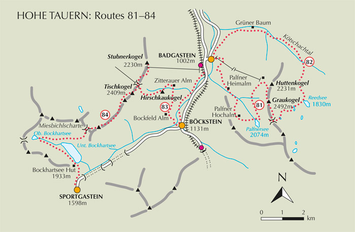
Located just outside the borders of the Hohe Tauern National Park, Badgastein overlooks the flat-bottomed Gasteinertal stretching to the north, while having easy access to both the upper valley stretching southwest to Böckstein and Sportgastein, and the lovely tributary valley of the Kötschachtal digging into the mountains southeast of the town. Easy walking can be found in each of these valleys, but more demanding routes venture onto the slopes of the surrounding mountains. A sample of four such routes is given below. To access these, the two-stage Graukogel chairlift and Stubnerkogel gondola are usefully employed. The first rises immediately above the town, the second rises to the west of Badgastein.
| Start | Badgastein (Graukokel lift: 1950m) |
| Distance | 8km |
| Height gain | 180m |
| Height loss | 1088m |
| Grade | 2 |
| Time | 4–4½hrs |
| Location | Southeast of Badgastein |
The Graukogel chairlift removes the need for a steep woodland walk to begin this route, thereby making it acceptable to most active visitors to the Gasteinertal. Densely vegetated hillsides on the way to the Palfnersee are a riot of colour in the early summer when alpenroses are in flower, but later in the season, masses of bilberries threaten to delay the walk. Note that the descent from the Palfnersee is very steep in places.


On the way to the Palfnersee
From the top station of the Graukogel lift, make your way uphill along the right-hand side of a restaurant, to a ski hut 4mins beyond it where there’s a path junction. Here you take the lower option to contour across the hillside heading southwest among masses of alpenrose and bilberry below the Graukogel.
After an initial steady traverse, the trail descends to cross a narrow stream, then rises to follow an undulating course curving left to gain a view into a hanging valley, before sloping downhill again to a trail junction at 1935m (40mins). Although the right branch goes to Badgastein via the Palfner Hochalm, we take the left fork to climb the stony, flower-starred hillside. On topping a rise from which you gain a view down to the Palfnersee, come to another junction and turn right.
This path cuts across rocky terrain along the northern edge of the Palfnersee (2074m, 1hr 20mins) to a second, much smaller tarn. Cross the outlet stream from this and continue across open countryside with Badgastein seen 1000m below. Over a grassy bluff descend to the ruins of Palfner Hochalm (1880m) which you reach about 40mins from the lake.
Go through a gate left of the hut ruins, and descend on a steep and narrow path over a heavily vegetated hillside, then into forest. About 1½hrs from the lake cross a stream on stepping stones below a waterfall. The gradient now eases and the path shortly becomes a track leading to Palfner Heimalm (1473m). Beyond the alm the track goes through forest, and in another 10mins you bear left at a junction, and wind downhill. The track becomes a surfaced road above a large farm, and shortly after passing the farm you come to another junction and bear right towards Café Windischgrätzhöhe (1230m).
Opposite the café take an insignificant-looking path which descends left through a meadow and into forest. The way then twists easily down among trees to a road. Bear left, turn a corner, then descend the steps of the Wasserfallweg to reach the centre of Badgastein.