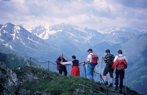
Walkers on the Huttenkogel
| Start | Badgastein (Graukogel lift: 1950m) |
| Distance | 12km |
| Height gain | 547m |
| Height loss | 1487m |
| Grade | 3 |
| Time | 5½hrs |
| Location | Southeast and east of Badgastein |
This very fine circular walk crosses two summits, visits a mountain lake and some tiny pools, and descends back to Badgastein through the Kötschachtal. It’s quite a demanding route that calls for sure-footedness and a good head for heights – a slip from the Graukogel ridge could have serious consequences – and the need for settled weather is essential. Since the descent from the Graukogel summit to the Palfnerscharte should only be attempted by experienced mountain scramblers, an alternative route is described in the box below. Views are far-reaching and varied, and in early summer the alpine flowers are magnificent. Keep alert for a sight of chamois.

Walkers on the Huttenkogel
Leaving the Graukogel lift at its upper station, pass along the right-hand side of the restaurant, and 4mins later reach a ski hut. Two paths will be found to the right of this hut. While the route to the Graukogel takes the upper path (no 525), the lower option (no 527) is an easier alternative route which is described below.
Taking the upper path, this is shortly joined by another trail known as the Dr Alfred Schwarz Weg. Twisting steeply up the hillside you gain the 2231m summit of the Hüttenkogel about 40mins from the chairlift. To the south rises the impressive Graukogel which, like the Hüttenkogel, is topped by a large cross.
The route to the Graukogel slants along the right-hand (western) side of the ridge crest. Rarely does it venture onto the actual crest, and it is only on the final steep ascent that exposure is such that a fixed cable safeguard is required. The 2492m Graukogel summit is reached about 50mins from the Hüttenkogel, and the panoramic view is worth savouring. The Hohe Tauern National Park boundary crosses the summit, and a sea of peaks fills the southern horizon, while the Kötschachtal lies enticingly below to the east.
The descent to the Palfnerscharte is exposed for much of the way (caution), going along the ridge crest, or close to it, often guided by waymarks with no other sign of a path. After about 40mins the route cuts down the left side of the ridge and soon improves. Finally, wander over broad slopes to gain the saddle of the Palfnerscharte (2321m) about 2hrs 45mins from the chairlift.
From the ski hut path junction, take the lower option (no 527) which takes you across a hillside carpeted with alpenrose and bilberry and pitted with tiny pools. After an initial contour you then descend about 20m among dwarf pine, after which there’s a change in vegetation with alder scrub dominating. In 40mins the path forks at 1935m. Take the upper trail, climbing steeply at times among dwarf pine and alpenrose, then top a rise at about 2090m where there’s another path junction by a large boulder. Bear left and resume the ascent to the Palfnerscharte which you gain about 1hr 45mins from the Graukogel chairlift.
On the east side of the saddle, slant leftwards to pass round the western end of the tiny Windschursee tarn, then cross a grassy bluff to find the green Reedsee lying about 400m below. About 45mins below the pass you come to an idyllic shallow groove in which there’s a stream flowing from two small pools, unseen from here. The stream is crossed on stepping stones, then you bear left (should you wish to visit the pools, turn right for about 2mins), and descend steeply to the Reedsee (1830m). This is reached about 45mins after leaving the Palfnerscharte.
Backed by the Tischlerkarkogel ridge, the Reedsee is set in a beautiful pine-rimmed hollow. A timber-built hut stands on its southeastern shore.
Bear left just above the lake, and soon after descend into forest. At times the path is steep, and after a while you can see the Kötschachtal track below. The way becomes even steeper, but eventually you reach the floor of the valley where you then wander downstream on the left bank of the Kötschachbach. Before long a bridge takes you over to the right bank (1½hrs from the Reedsee) where you walk down the dirt road to Jausenstation Himmelwand (refreshments) and continue to the hamlet of Grüner Baum (1066m, 4hrs 45mins, accommodation and refreshments).
Continue downvalley on a footpath which crosses to the left of the road by Hotel Stubnerhof. This path is the Kaiser Wilhelm Promenade, and it leads all the way to the centre of Badgastein in about 40mins from Grüner Baum.