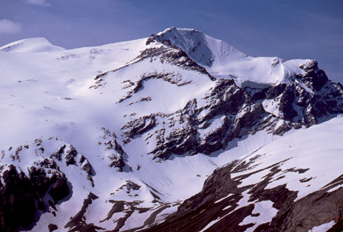
Snowpeaks capture your attention throughout the walk along the Sedlgrat
| Start | Kaprun (Mooserboden: 2036m) |
| Distance | 2.5km (one way) |
| Height gain | 389m |
| Grade | 2 |
| Time | 2hrs (+1–1½hrs return) |
| Location | South of Kaprun |
South of Kaprun, at the upper end of the Kaprunertal on the edge of the National Park, lie two large reservoirs, the Wasserfallboden at 1672m, and the higher Mooserboden. Both are flanked by high mountains, but the Mooserboden’s backdrop is truly spectacular. No wonder it’s such a magnet for tourists. A number of short walks are accessible from the bus terminal at the Mooserboden dam; arguably the best of the bunch is that which climbs to the Scharfer Grat viewpoint. Although short, it would be worth taking a picnic lunch and making a day of it, for it would be so easy to spend several hours simply enjoying the views!
Public buses make the 6km journey from Kaprun to the Kesselfall Alpenhaus roadhead, where there’s plenty of free parking for visitors with their own transport. From there buses continue through a tunnel to the bottom station of the Lärchwand funicular, a huge lift platform capable of transporting 185 passengers up a slope to gain 430m. A second bus then takes you through more tunnels alongside and above the Wasserfallboden reservoir, eventually arriving at the Mooserboden dam where there’s a restaurant, the Heidnische Kirche, and an information centre telling the history of the Tauernkraft pumped storage scheme.
The path to take is a broad one which starts at the western side of the bus terminal, and is signed as the Panoramaweg Sedlgrat. Several other paths soon break from it, and as you gain height the trail becomes narrower, while the gradient steepens as it twists up a flower-rich hillside from where views grow increasingly dramatic.
Having gained almost 300m, about 1hr from the reservoir you come to a sign announcing the Hohe Tauern National Park boundary. Just beyond this there’s a trail junction where you ignore the right-hand option and continue ahead, the slope less steep now. The way is obvious, although care needs to be exercised if there is snow still lying. The Scharfer Grat viewpoint is reached in a little under 1hr from the National Park’s boundary. At 2425m this is the culminating point of the Sedlgrat. From it you have a splendid grandstand view of the Kaprunertal’s headwall where the Karlinger Kees glacier hangs against the flank of the Hohe Riffl, while across the valley to the east the imposing Grosses Wiesbachhorn (3564m) dominates. Climbed in the late 18th century, this was the first major summit in the Eastern Alps to be won.

Snowpeaks capture your attention throughout the walk along the Sedlgrat
Allow a little over an hour for a return to the reservoir.
Note The right-hand path breaking away beyond the National Park’s boundary offers an uncomplicated ascent up a broad ridge to the 2669m Kleiner Griesskogel in 1hr 15mins. A second summit may also be gained from the Scharfer Grat. This is the 3066m Griesskogel (sometimes known as the Grosses Griesskogel to avoid confusion with the lower summit). The route for this turns sharply to the right at the Scharfer Grat to climb the narrowing grat or ridge, with some scrambling in the upper section, before coming onto the summit, a satellite peak of the great pyramid of the Hocheiser which rises in the southwest.