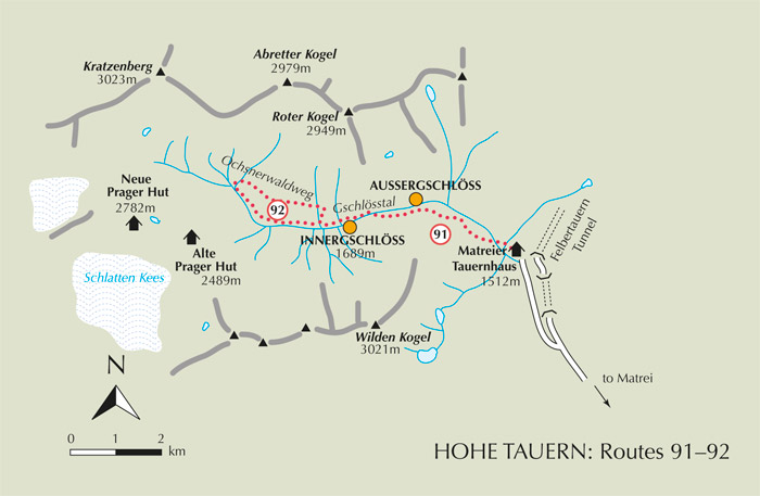
Matrei is centrally placed for a wide range of walks in the Venediger and Granatspitz groups, as well as routes among the Lasörling group south of the Venediger range. Buses serve all the main valleys, and there’s a fair number of car parks for visitors with their own transport. A very small number of walks (out of the huge number possible) are fully described below. These take place in the Gschlösstal, Virgental and on the east flank of the Tauerntal.
The Gschlösstal drains the eastern side of the Grossvenediger, and feeds into the upper Tauerntal near the Felbertauern Tunnel. To get there from Matrei either take a taxi, a bus (ask for the Matreier Tauernhaus; there’s a bus stop on the main road 2km from it) or drive 14km upvalley towards the Felbertauern Tunnel, then take a signed minor road on the left which leads to a large car park. Just beyond this stands a small chapel opposite the Matreier Tauernhaus, a large and locally famous building with 60 beds, open all year (tel 04875 881) and a popular base for numerous excursions.
| Start | Matreier Tauernhaus (1512m) |
| Distance | 4km (one way) |
| Height gain | 189m |
| Grade | 1 |
| Time | 1hr 15mins (+1hr return) |
| Location | North of Matrei |
Although this is a short and fairly undemanding valley walk, it’s rewarding for the quality of the views and the gentle charm of the Gschlösstal, a beautiful, sparsely-inhabited valley headed by the Grossvenediger.

Walk upvalley past the Matreier Tauernhaus along the continuing road for about 5mins, then take a footpath on the left. Crossing a bridge, follow the river upstream for a short distance before going between fences to a broad crossing path where you turn right. Apart from the intrusion of high-voltage power cables, this section of the valley is very attractive, with hay meadows and forested slopes, and waterfalls that streak the bare rock of the upper hillsides.
Leave the broad path about 15mins from the Tauernhaus, and take a narrower trail cutting left, signed to the Venedigerhaus and Innergschlöss. At first skirting the forest edge, the path then rises among trees, steeply in places, to gain 100m or so, before contouring in and out of trees, with wild raspberry canes bordering the trail. The way climbs again, now using several timber-braced steps, to reach an open grassy bluff at 1701m, from where you gain a brief view of the Grossvenediger.
Now losing height the group of time-worn buildings of Aussergschlöss appear below on the opposite bank of the river. As you emerge from the trees, a magnificent view is gained to the head of the valley where the Grossvenediger, adorned by the broad ice-sheet of the Schlatenkees glacier, captures your attention.
Note It would be worth descending to a footbridge spanning the river in order to visit the pretty huddle of buildings that comprise Aussergschlöss (55mins), one of which is a berghaus restaurant (refreshments).
The continuing walk to Innergschlöss remains on the south bank of the river where the path crosses pastures and goes through lightly wooded areas of larch, pine and fir, with juniper and bilberries growing among the rocks. Ten minutes from the Aussergschlöss footbridge junction, come to another timber footbridge that takes you across to the north bank, where you then bear left and walk along the dirt road to Innergschlöss (1689m, 1hr 15mins, accommodation and refreshments).
Innergschlöss is not so much a village as two rows of one-time farm buildings facing each other across the river. The last building on the left is the large, privately-owned Alpengasthof Venedigerhaus which has 24 beds and 8 dormitory places, and is open from mid-May until the end of October (tel 04875 8820). Not only does the Venedigerhaus make a popular valley base for walks and climbs, it also has a restaurant invariably busy with day visitors. Taxis (motorised and horse-drawn) run a regular service between here and the Matreier Tauernhaus.

Innergschlöss