| Start | Ströden (1403m) |
| Finish | Matreier Tauernhaus (1512m) |
| Distance | 48km |
| Grade | 3 |
| Time | 6–7 days |
| Location | Northwest of Matrei |
| Highest point | Zopetscharte (2958m) |
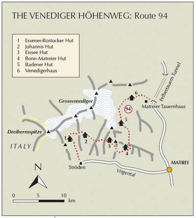
The Venediger Höhenweg is understandably one of Austria’s classic hut-to-hut routes. Making a counter-clockwise loop round the south and eastern limits of the Venediger group, the tour is a scenically dramatic one, with some high passes to cross and a diverse range of huts in which to stay overnight. Since it is not a circular tour it is advisable to take a bus as far as Ströden for the start of the route, and either taxi or bus from the Matreier Tauernhaus down to Matrei at the end of the tour.

Day 1 Taking into account time needed to travel from Matrei to Ströden, it’s as well that this first stage is a short one. Wandering north of Ströden through the Maurer Tal, you reach the Essener-Rostocker Hut at 2207m in 2½–3hrs, as described above in Route 94. Although it is only a short stretch, the valley is attractive, and the backdrop to the hut uplifting, and given sufficient time on arrival, there are some exciting landscapes to study from a path which extends along the moraine wall.
Day 2 This and the subsequent two stages move the route eastward across a series of tributary glens gouged out by long-vanished glaciers. Dividing these glens, projecting ridges or spurs have to be crossed or skirted, thereby giving the route a helter-skelter profile. On this second day, a trail is taken initially towards the wild head of the Maurer Tal before turning eastward on the Schweriner Weg. This climbs the boulder-strewn east flank of the valley, crosses a couple of streams and zigzags up grass then rocks to gain the Türmljoch (2845m) on the dividing ridge between the Maurer Tal and Dorfer Tal. Descend to the east over rocks, then swing northeast along the crags of the Aderkamm before cutting down below them heading south. Cross the Dorferbach by footbridge, and wander across meadows to reach the DAV’s Johannis Hut at 2116m, about 3½hrs after setting out from the Essener-Rostocker Hut.
Day 3 The highest point of the Venediger tour is crossed on this stage, on the way to the Eissee Hut. Leaving the Johannis Hut a very steep zigzag path climbs southeastward up grass slopes, then forks. The right branch is the Sajat Höhenweg which leads to the privately owned Sajat Hut, while the left-hand path is the continuing route of the Venediger Höhenweg which turns north, then east through a stony corrie, still climbing with magnificent high mountain views, to reach the 2958m Zopetscharte. Given settled weather, this narrow pass is a splendid place on which to sit and absorb the untamed nature of the mountains, before descending steeply (some cable safeguards) down to boulder slopes into the Timmeltal with the 3300m Weissspitze at its head, and Hexenkopf and Hoher Eichham opposite. The Eissee Hut (2520m) is privately owned, with 14 beds and 31 dormitory places, and is reached about 4hrs or so from the Johannis Hut.
Day 4 A gentle start to this 3½–4hr day takes path no 923 on an easy contour heading southeast below the Hoher Eichham, and round a minor spur of the Wun Spitze to be joined by another path climbing from the Timmeltal. Rounding the southwest spur of the Wun Spitze the höhenweg heads east then northeast, before making a sudden short climb. The way eases, then climbs again, this time to mount the ridge of the Esels Rücken. A sharp little gully has to be descended on the east side of the ridge, below which you go down to a boulder field, then curve round the head of the Nilltal over rocks and boulders on the way to the Bonn-Matreier Hut at 2745m. Given sufficient energy, it might be tempting to make the 1½–2hr ascent of the 3209m Sailkopf, northwest of the hut. From it, there’s said to be a wonderful view of the Grossglockner.
Day 5 This is the longest (6hrs) and most challenging stage of the Venediger Höhenweg, with the crossing of the 2882m Galten Scharte being marked as Nur für Geübte – ‘only for the experienced’. In truth the route is not especially difficult in reasonable conditions, but the rock is very poor, loose and potentially dangerous on the descent from the pass after rain or recent snowfall. Caution is advised. From the hut, the path to take initially heads north before swinging to the right to cross the narrow Kälber Scharte (2791m) below the Raukopf. Below the pass you descend into another boulder field, then curve round to the left to make a rocky zigzag approach to the Galten Scharte between the Maurer Röte and Galten Kogel. The descent from here demands caution, for it’s exposed (fixed cables), the shale is unstable and the path has countless twists. Cecil Davies gleefully recalls the comment made to him by a Dutch climber who complained that there was ‘no proper rock’ on this side of the pass. Now the route works its way down into a small tributary valley, crosses its stream, then heads north along the west flank of the Frossnitztal to the tiny Achsel tarn and a path junction. Fork left and rise steadily to another junction where you turn left for the final steep climb to the Badener Hut, which stands at 2608m below the Frossnitzkees glacier on the east flank of the Weissspitze.

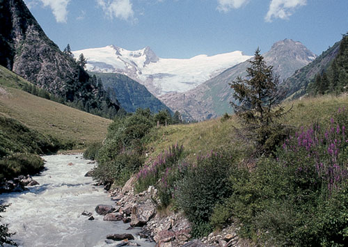
Grossvenediger, seen from the Gschlösstal
Day 6 Four hours should be sufficient (in reasonable conditions) to reach Innergschlöss in the Gschlösstal, with another 1–1½ hrs of easy walking downvalley to Matreier Tauernhaus and the end of the tour. This is a landscape to absorb; to drift slowly through. So perhaps it is better to make this a two-day stage. Dreaming is fine, but not when you’re moving, so keep your concentration as you leave the Badener Hut and work a way northwest across rocky slopes, pass below the shrinking Kristallwand Kees glacier, where an alternative path cuts to the right for the Wilden Kogel, and begin the climb to the 2770m Löbben Törl, the crux of the day’s route. From the pass you gain a fabulous view across and up the Schlatenkees glacier to the Grossvenediger, then make your way down below the glacier to a moraine rib, and down this to post-glacial pools and streams, and the last steep drop into the Gschlösstal, leaving a short, pleasant walk through meadows to the Venedigerhaus at Innergschlöss, as delightful as any valley base in which to spend a last night among the mountains.
Day 7 Unless you had a good reason to continue down to the Matreier Tauernhaus at the end of yesterday’s stage, the hour-long ramble downvalley could be extended by visiting a tiny chapel built into the rocks beside the dirt road on the way to Aussergschlöss, and having refreshment at Aussergschlöss itself before crossing to the right bank of the river and following a good footpath to the Tauernhaus road for a bus (or taxi) down to Matrei.