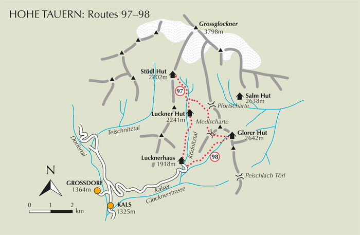
South of Kals its valley is known as the Kalsertal. It climbs out of the Iseltal between the lower Granatspitz group on the west and the Schober group to the east, and on the journey up to Kals a highlight is the glorious Schlier waterfall which bursts from the eastern mountains. At this point you also gain an exciting view of the Grossglockner. From Kals on, the valley is the Dorfertal (not to be confused with the Dorfer Tal tributary of the Virgental) which divides the Granatspitz from the Glockner group. A major tributary of the Dorfertal cuts into the mountains at Kals. This, the Ködnitztal, is made accessible by the Kalser Glocknerstrasse toll road, built between 1976 and 1980, which rises almost 600m in 7km. From the roadhead at the Lucknerhaus the Grossglockner announces its supremacy; there are some great walks to be had in its shadow, and several huts to visit. An infrequent bus service from Kals journeys up the Glocknerstrasse, while for those with their own transport, there’s a large car park at the roadhead. The Lucknerhaus hotel by the car park has 39 beds and 16 dormitory places, and is fully open from February until the end of October (tel 04876 8555).
| Start | Kals (Lucknerhaus: 1918m) |
| Distance | 5km (one way) |
| Height gain | 884m |
| Grade | 2–3 |
| Time | 2½–3hrs (+2hrs return) |
| Location | North of the Lucknerhaus |
Although the Stüdl Hut is primarily used by climbers as a base from which to tackle the Grossglockner and routes on the Glocknerwand, its situation on the Fanatscharte in view of Austria’s highest peak, makes it an obvious goal for walkers, either as a there-and-back trek, or on a circular walk with a return to Matrei via the Teischnitztal.
From the car park opposite the Lucknerhaus, either take the track on the left (west) side of the river, or the footpath on the east bank. Heading north, the track cuts between meadows and, rising steadily, crosses the Ködnitzbach to be joined by the footpath. It then climbs to the privately owned Luckner Hut (2241m, accommodation and refreshments) about 1hr from the roadhead.
The track ends at the hut’s goods lift, with a footpath continuing from it. About 15mins later, the Glorer Hut path breaks to the right (see Route 98), but we keep ahead and soon recross the Ködnitzbach. The way now climbs above the stream and comes to a path junction at 2550m, where the right branch is the Johann Stüdl Weg, linking the Stüdl and Salm Huts. Keep left and zigzag northwest below the Blaue Wand crags, then suddenly emerge onto the Fanatscharte saddle where the Stüdl Hut occupies a prime position.

The Grossglockner dominates the upper Ködnitz Tal
Note If you took the bus to the Lucknerhaus, a return to Matrei via the Teischnitztal (the valley which lies below the Fanatscharte on the west) makes a good alternative option. Path no 712 descends the east flank of the Teischnitztal, and eventually joins a road a little south of the Moa-Alm. Either walk down the road to Kals, or descend to the bed of the valley where a trail can be followed downstream alongside the Kalserbach as far as Grossdorf, then road from there to Kals (about 3½hrs from the Stüdl Hut).