“THE SEA COVERS NEARLY THREE-FOURTHS OF THE surface of the earth, and, until within the last few years, very little was known with anything like certainty about its depths,” the Scottish naturalist Wyville Thomson wrote in 1873. “The popular notion was, that after arriving at a certain depth the conditions became so peculiar . . . as to make life of any kind impossible, and to throw insuperable difficulties in the way of any attempt at investigation. Even men of science seemed to share this idea.” Because no one saw any use for the oceanic depths, Thomson explained, everyone ignored them. Fishing, whaling, and sailing took place at or near the surface, where life flourished. According to Edward Forbes, Thomson’s predecessor as the University of Edinburgh’s professor of natural history, water pressure became too great, sunlight too scant, and oxygen too scarce below three hundred fathoms (or eighteen hundred feet) for life to exist. After Forbes’s death in 1854, Thomson came to realize that scientists had never actually looked for life on the ocean floor and had closed their eyes to evidence of its existence.1
In the late 1850s, the triumph of electric telegraphy in revolutionizing communications on land led ambitious European and American entrepreneurs to try connecting their continents by a telegraph cable from Ireland to Newfoundland. “Practical men mapped out the bed of the North Atlantic,” Thomson noted, “and devised ingenious methods of ascertaining the nature of the material covering the bottom.”2 The influential physicist William Thomson, later made Lord Kelvin, invested heavily in the project and worked to bring the Royal Society on board with the help of the society’s vice president, invertebrate zoologist and science popularizer William B. Carpenter.
The project required deep-sea sounding, dredging, and trawling. As early cables snapped or failed, engineers hauling them up from miles down found them entangled or encrusted with living things. When the effort to lay a transatlantic cable finally succeeded in 1866, attention turned toward other oceans. Soon the globe was girdled with electric cables. The deep-sea floor had become useful for commerce, and so scientists began studying it.
With the Royal Society’s backing, Wyville Thomson, Carpenter, and the wealthy Welsh conchologist J. Gwyn Jeffreys conducted deep-sea dredging expeditions aboard the British navy vessels Lightning and Porcupine each summer from 1868 to 1870. The Admiralty did not specially outfit these ships for research, and the vessels did not venture more than a couple of weeks’ cruising distance from Britain in the brief time afforded for each trip. At various stations in the North Atlantic and Mediterranean Sea, researchers sounded the bottom, collected samples, and measured the water temperature at different levels. Much of the equipment was experimental. Nevertheless, the findings astounded experts and intrigued the public. By looking where no scientist had looked before, Thomson and his colleagues discovered a new world beneath the sea.
Four findings from these voyages pointed researchers back in geologic time and south toward Antarctica. First, the seabed had ridges, valleys, and plains like surface land—only much grander in scale. Second, white ooze composed largely of the chalky remains of tiny plankton covered much of the sea floor. “One can have no doubt, on examining this sediment, that it is formed in the main by the accumulation and disintegration of the shells of globigerina,” Thomson wrote, “an animal formation in fact being formed very much in the same way as in the accumulation of vegetable matter in a peat bog, by life and growth above, and death, retarded decomposition, and compression beneath.” Within this globigerina ooze, Thomson tentatively detected a gelatinous matter resembling egg whites that Royal Society Secretary T. H. Huxley hastily christened Bathybius haeckelii in honor of German evolutionist Ernst Haeckel, who had speculated about the origins of life in marine slime. “If this have a claim to be recognized as a distinct living entity,” Thomson commented on the supposed substance, “it must be referred to the simplest division of the shell-less rhizopeda, or if we adopt the class proposed by Professor Haeckel, to the monera.”3 Some evolutionists dared to hope it might represent the primordial source of all life.
A third finding also excited widespread public interest. Life on the bottom was not limited to simple forms. The dredges hauled up sponges, corals, crinoids, starfish, sea urchins, crustaceans, mollusks, and even some true fishes, many in forms never before seen by humans except perhaps as fossils from past geologic periods. A few ancient species, thought extinct, were found alive. “These abysses of the ocean,” Thomson wrote in his account of the expeditions, “are inhabited by a special deep-sea fauna, possibly as persistent in its general features as the abysses themselves.” Further linking the modern abyss with the geologic past, the composition and structure of the white ooze resembled that of the ancient chalk beds of Europe. “We might be regarded,” Thomson proclaimed, “in a certain sense as still living in the cretaceous period.”4
Finally, the researchers found that, unlike near the surface, temperature in the deep did not drop at higher latitudes or greater depths. Even major surface currents like the Gulf Stream had little impact below two hundred fathoms. Instead, they detected a pattern of distinct temperature layers spanning the entire survey area in the North Atlantic. “The sea was warm or cold at all depths, according to the source from which each layer or current of water was derived,” Thomson wrote.5
Deep in the North Atlantic, Thomson and Carpenter discerned a slow, steady undercurrent of cold water, only a few degrees above freezing, flowing from south to north. It must come from polar regions, they reasoned, and because cold water is heaver than warm water, gravity could propel it along the seabed. While large landmasses restrict “the communication between the North Atlantic and the Arctic Sea,” Thomson noted, “the communication with the Antarctic basin is as open as the day;—a continuous and wide valley upwards of 2,000 fathoms in depth stretching northward along the western coasts of Africa and Europe.”6 Cold surface water, they proposed, sinks in the Antarctic, travels north along the seabed, gradually warms, and rises in the far north. Acting like the coolant in a refrigeration system, an Antarctic undercurrent could maintain the ocean depths in a steady state while slowly circulating seawater from top to bottom and south to north.
For Victorian scientists struggling to come to terms with Darwinism, finding layers of constant temperature in the deep oceans had profound significance: it could account for the distribution of sea creatures across the globe. At depth, the tropics would not serve as a natural barrier between temperate or even polar zones. It might also explain the discovery of ancient species in deep oceans. If environmental change drove organic evolution, Thomson speculated, older forms might survive in a deep-sea environment stabilized by an Antarctic undercurrent. Zoologists could look there and toward Antarctica itself for so-called living fossils and perhaps find proof of Darwin’s still-novel theory.
These findings from the summer cruises of Lightning and Porcupine, coupled with interest in the deep seas generated by transoceanic telegraph cables, stirred the British government to launch the Challenger expedition and point it toward the Antarctic. Once proposed, the venture came together rapidly. Late in 1871, the Royal Society appointed a committee composed of Thomson, Carpenter, Jeffreys, Huxley, Joseph Hooker, the future Lord Kelvin, and others to consider Carpenter’s call for a government-funded deep-sea dredging expedition to circumnavigate the globe. The committee promptly recommended that the navy outfit a ship, with a staff of civilian scientist on board, “to investigate the Physical Conditions of the Deep Seas in the great ocean-basins—the North and South Atlantic, the North and South Pacific, and the Southern Ocean (as far as the neighborhood of the great ice-barrier).” The expedition would also “examine the distribution of Organic Life throughout the areas traversed” with particular reference “to the connection of the present with the past condition of the globe.”7 Scarcely three months after the society transmitted this recommendation to the government, the Admiralty accepted it and rushed to launch the expedition by the end of 1872.
“An early day of the ensuing week will witness the departure of the most important naval surveying Expedition which has ever been sent forth by any country,” the Times of London reported on December 5, 1872.8 HMS Challenger, a square-rigged corvette with auxiliary steam power refitted as a floating marine laboratory, became the first government ship ever specially dispatched for oceanographic research. Despite his young family, the forty-two-year-old Thomson agreed to lead the scientific staff on the anticipated four-year cruise. Five junior researchers accompanied him, including thirty-one-year-old Canadian-born naturalist John Murray. The original Royal Society committee, augmented by the addition of evolutionary biogeographer Alfred Russel Wallace, drafted the expedition’s instructions.
“The principal object of the proposed expedition is understood to be to investigate the physical and biological conditions of the great ocean basins,” the instructions began. Scarcely mentioning telegraph cables, they dwelled instead on the scientific benefits of deep-sea research: “The investigation of various problems relating to the past history of the globe, its geography at different geological epochs, and the existing distribution of animals and plants, as well as the nature and causes of oceanic circulation, will be greatly aided by a more accurate knowledge of the ocean-bed.”9 In addition to sounding, dredging, and measuring deepwater temperatures at regular stations, the expedition was to collect biological specimens and keep regular records of air pressure and temperature. Since winds blow toward areas of relative low air pressure, finding constant low pressure in the far south would fit Thomson’s hypothesis that water carried north by the Antarctic undercurrent returned south as moisture in the air.
The expedition’s route reflected its mission. After crisscrossing the Atlantic four times and rounding the Cape of Good Hope, Challenger was to dip south across the Indian Ocean by way of the Kerguelen Islands to the Antarctic ice pack, then take a circuitous path through the Pacific before recrossing the Atlantic to return home. “This route will give an opportunity of examining many of the principal ocean phenomena,” the instructions noted, “including . . . the specially interesting fauna of the Antarctic Sea.”10 In an era when scientists had just begun reinterpreting nature from an evolutionary perspective, a comparison between this little-known fauna and the better-known one of the Arctic Ocean intrigued zoologists, climatologists, and oceanographers looking for links over time and space.
The committee wanted Challenger to approach the ice pack from the Indian Ocean because it presented Antarctica’s least familiar face. Earlier explorers had discovered large Antarctic bays—the Ross and Weddell seas—south of the Pacific and Atlantic oceans. If this pattern held in the Indian Ocean, it might provide clues for understanding ocean circulation and the Antarctic undercurrent. As these instructions suggested, the expedition’s organizers looked toward Antarctica for answers to basic scientific questions.
The Challenger naturalists found answers—and new questions—everywhere they looked, especially in the Antarctic. Along the way, they sent back observations and preliminary findings to the Admiralty, the Royal Society, the Times of London, and the science journal Nature. The expedition traveled eighty thousand statute miles between December 1872 and May 1876, spending about half of this time at sea. “In consequence of the special nature of the mission,” expedition naturalist Henry Moseley complained, “the sea voyages were tedious and protracted, the ship being constantly stopped on its course to sound and dredge.”11 Thomson reported stops at 362 observing stations. The data overwhelmed him. He collapsed in 1881 and died the following year, after writing two volumes on the Atlantic portion of the voyage. Murray took over the task of preparing the expedition’s technical reports, which ran to fifty volumes and gave birth to the modern science of oceanography. Both men were knighted for their service.
Although the results fascinated scientists and captured widespread public attention, the work at sea was deadly dull. The deepest station sounded at about five miles below the surface, the average at nearly three miles. At such depths, it could take the ship’s officers and crew twelve hours or more to lower and raise the equipment. “At first, when the dredge came up, every man and boy in the ship who could possibly slip away, crowded round it, to see what had been fished up,” Moseley recalled. “Gradually, as the novelty of the thing wore off, the crowd became smaller . . . and as the same tedious animals kept appearing from the depths in all parts of the world, the ardour of the scientific staff even abated.” Finger-pointing invariably ensued when the dredge came up empty or snagged on the bottom. Over a quarter of the crew deserted, many in Cape Town or Melbourne just before or after the strenuous Antarctic portion of the trip. Noting that conditions could have become much worse, T. H. Huxley toasted Thomson on his return, “When men are shut up together in a limited society, whether it be a cathedral town or a ship, they begin to hate one another unless the bishop is a very wise person. In this case I do not doubt that the bishop was a very wise person.”12
Anticipating difficulties during the unusual mission, the Admiralty took special care in picking the crew and outfitting the ship. All the sailors, officers, and scientists volunteered for the voyage. For captain, the navy tapped George Nares, an exceptional surveyor who had served in the Arctic during the Franklin searches. Recalled to lead the 1875 British Arctic Expedition after completing Challenger’s work in the Antarctic, Nares was replaced by Frank Thomson for the final eighteen months of the cruise. Although the captain retained overall command, the civilian scientists called the shots on matters of where, when, and how to conduct research—a precedent that the Royal Society later tried to impose on the Discovery expedition. Wyville Thomson and the captain had paired cabins with a shared sitting room, and all on board had larger quarters than normal for a navy vessel. “Sixteen of the eighteen 68-pounders which form the armament of the Challenger have been removed, and the main-deck is almost entirely set aside for the scientific work,” Thomson reported. “I feel justified in going even so far as to say that the arrangements for scientific work in the Challenger leave little or nothing to be wished for.”13 Navy discipline was relaxed to facilitate research.
“Never had any expedition yet left our shores so well provided with the means of adding to the hydrographical and scientific knowledge of the world,” Nares declared on the ship’s departure.14 Although he stressed the practical value of potential findings for laying telegraph cables, others could not suppress their sheer wonder at what lay beneath the sea. One sailor penned doggerel about the scientists and their mission:
Don’t yer see these learned bosses have come to search the ocean, But for what, old son, ‘twixt you and I, I’m blow’ed if I’ve a notion. I’ve ‘eard ‘em talk of Artic drift and valleys under water, And specs next week to find they’ve nab’d old Davy and his darter. Of course you know they’ve got to find the link atween the species, Some say as there’s a ‘boon aboard as liks it all to pieces.15
After reviewing expedition plans and preparations, RGS President Francis Galton predicted, “The voyage of the Challenger would be different from any other that had ever been undertaken by this or any other country.” He then added about its backers, “Of course, they might reasonably look for great results.”16
They were not disappointed. “The scientific results of the Challenger expedition have far exceeded our most sanguine anticipation,” Royal Society President Joseph Hooker declared even before the cruise ended.17 Like many British naturalists, he had been following the expedition’s progress closely from letters and reports sent back by Thomson and others. In general, those results refined the four principal findings of earlier dredging expeditions.
Through soundings conducted during the voyage, Thomson extended his rough map of sea-floor topography to encompass the globe. “We now know,” he declared, “that the sea covers a vast region which is to a certain degree comparable with the land—a region which has its hills, valleys, and great undulating plains.” The expedition found its deepest bottom at 4,475 fathoms in the western Pacific, or 2,000 fathoms deeper than anything found from Lightning or Porcupine. “The thermometers, which were tested to withstand a pressure of four tons on the square inch, were all broken with the exception of one,” the Times reported on this deepest sounding. The water at depth was so still that some mercury from the broken thermometers dropped straight down into the sounding tin below.18
Deeper soundings enabled the Challenger naturalists to refine emerging scientific views of the ocean floor. The white ooze found on the deep-sea bed by earlier expeditions gave way to a transitional gray ooze at about 1,500 fathoms and then, at about 2,200 fathoms, to a red clay bottom. This finding led Thomson to accept Murray’s explanation that the microorganisms whose shells created the white ooze lived at or near the surface and that, by a certain depth, acidic deep-ocean water dissolved calcite from the remains raining down below. “The red clay is essentially the insoluble residue,” Thomson reported from Australia, “of the calcareous organisms which form the Globigerina ooze after the calcareous matter has been by some means removed.” Anywhere they sounded, those on board soon could predict the composition of the bottom simply from the water’s depth. Nowhere, however, did they find the gelatinous substance supposedly detected by earlier expeditions. Thomson suggested that it resulted from dousing deep-sea specimens with preserving fluid. “Prof. Thomson speaks very guardedly,” Huxley conceded in Nature, “but since I am mainly responsible for the mistake, if it be one, of introducing this singular substance into the list of living things, I think I shall err on the right side in attaching greater weight than he does to the view which he suggests.”19
As with earlier expeditions, discoveries about deep-sea creatures sparked the most interest. “The Challenger Expedition is the final establishment of the fact that the distribution of living beings has no depth-limit; but that animals of all the marine invertebrate classes . . . exist over the whole of the floor of the ocean,” the Times of London declared. “Never since King John proclaimed at Hastings his dominion over the oceans have our ships brought home more precious spoil.”20 Many deep-sea specimens caught in Challenger’s dredge had enlarged eyes; others, none at all. Some had a phosphorescent glow, apparently to compensate for the lack of sunlight, or strikingly bizarre forms. Most represented species new to science, with many of these collected at the expedition’s most southerly stops. “The deep-sea fauna of the Antarctic has been shown by the Challenger to be exceptionally rich, a much larger number of species having been obtained [there] than in any other region visited,” Murray reported in the scientific manual for Scott’s Discovery voyage. Noting the prevalence of large mouths and sharp spines on the creatures, the manual added, “The depths of the sea bear evidence to the truth of the Frenchman’s summing up of Life as the conjunction of the verb ‘I eat,’ together with its terrible correlative ‘I am eaten.’”21
From his earlier work, Thomson had predicted that the same deepwater species would be widely distributed across the ocean floor and that many would be living fossils from the Cretaceous period. Challenger’s haul upset his thinking. “The fauna of the deep sea is wonderfully uniform throughout,” Thomson told the BAAS upon his return, “and yet, although in different localities the species are evidently representatives, to a critical eye they are certainly not identical.” Further, although “the general character of the assemblage of animals is much more nearly allied to the cretaceous than to any recent fauna,” current species “are certainly in very few instances identical” with those of the Cretaceous period.22
Deepwater species evolved both over time and as they migrated, Thomson concluded, with the evolutionary pattern pointing back toward the wide moat of water surrounding Antarctica. “The most characteristic abyssal forms, and those which are most nearly related to extinct types, seem to occur in greatest abundance and of largest size in the Southern Ocean,” he wrote, “and the general character of the faunae of the Atlantic and the Pacific gives the impression that the migration of species has taken place in a northerly direction.”23 This, of course, nicely fit his theory of an Antarctic undercurrent.
From observations aboard Lightning and Porcupine, Thomson had argued that cold waters of the deep Atlantic came from Antarctica. Water-temperature readings taken during the Challenger expedition confirmed this theory and extended it to encompass the Pacific and Indian oceans. “Like the similar mass of cold bottom-water in the Atlantic, the bottom-water of the Pacific is an extremely slow indraught from the Southern Sea,” he reported from Chile. “That it is moving, and moving from a cold source, is evident from the fact that it is much colder than the mean winter temperature of the area which it occupies, and colder than the mean temperature of the crust of the Earth; that it is moving in one mass from the southwards is shown by . . . the gradual rise of the bottom-temperatures to the northward.” Reflecting this view, Thomson began referring to the world’s three great oceans as mere “gulfs” of the Southern Sea.24 With this, the Challenger expedition turned the world upside down from how Europeans traditionally saw it and moved Antarctica from the periphery of oceanic circulation to the center. As scientists came to understand the process, cold water flowing from Antarctic sources across the seabed to the Northern Hemisphere cools the ocean depths and regulates the global climate.
The theory of an Antarctic undercurrent rested on hundreds of water temperature readings taken across the globe. In contrast, Thomson’s elaborate but less authoritative account of how Antarctica fit in the process relied largely on circumstantial evidence collected during the three weeks in February 1874 that Challenger spent among Antarctic icebergs and skirting the ice pack, never penetrating more than eight nautical miles south of the Antarctic Circle. With summer drawing to a close and his ship not reinforced for sailing in ice, Nares feared that a longer stay or deeper intrusion would doom the expedition. As it was, it suffered a narrow escape when it collided with an iceberg during a gale, losing its jibboom and nearly toppling its topgallant masts.
During this period the crew sounded, dredged, and took deep-water readings at four stations among the icebergs, recording depths ranging from eight thousand to twelve thousand feet. Challenger approached the pack south of the Kerguelen Islands in the Indian Ocean, where Thomson thought a bay like the Ross or Weddell seas should exist. “At first, all the icebergs seen were numbered each day, and their positions noted down,” Moseley wrote, “but when we came to have 40 in sight at once this plan was abandoned.” The dredge brought up fragments of feldspar, quartz, granite, slate, gneiss, and other continental rocks and minerals. Because this material clearly came from icebergs calved from Antarctic glaciers, the naturalists concluded that Antarctica must be a continental landmass. Ross and other explorers had reported land in the region but never knew if what they saw represented oceanic islands or parts of a continent. Based on the dredging, Thomson confidently proclaimed “that the area within the parallel of 70° S. is continuously solid, that is to say, that it is either continuous land or dismembered land fused into the continental form by a continuous ice-sheet.”25
As this comment suggested, dredging did not resolve whether Antarctica was contiguous land or an archipelago of continental islands. Available evidence pointed toward the latter. “The icebergs . . . were usually from a quarter to half a mile in diameter, and about 200 feet high,” Nares wrote. “They were remarkably clear of rocks or stones, although, each time we have dredged, sufficient evidence was brought up to show that the bottom of the sea is fairly paved with the debris brought by them from Antarctic lands. In shape, they were always tabular.” One man on board compared them to “sugar-covered cakes divested of all colored ornaments.”26 The Challenger naturalists thought these distinctive flat bergs must come from flat land, unlike the familiar pinnacled icebergs of the North Atlantic that calved from Greenland’s mountain glaciers.
This observation, combined with Ross’s description of the Great Ice Barrier, led the naturalists to infer that Antarctica consisted mostly of low islands and shoals covered by an ice sheet that stood less than two thousand feet high. As snow accumulated on the ice sheet, they proposed, the added weight would push its sides outward across the low-lying area and into the surrounding ocean, creating the Ice Barrier that Ross described as rising two hundred feet above the sea. Like an iceberg, the floating end of a two-thousand-foot-high glacier should rise nearly two hundred feet above sea level. As the ice shelf extended further from the support of land, they reasoned, chunks would break off as tabular icebergs. Drifting north with the current, they would drop continental debris from their undersides and feed ice-cold melt-water into the Antarctic undercurrent. Even the Ross and Weddell seas, Thomson added, might be “notches” in the Ice Barrier caused by warm water from the great oceans to the north. “The ‘continent,’” he suggested, “may consist to so great an extent of ice as to be liable to have its outline affected by warm currents. . . . If this be so it would at all events indicate that the ‘Antarctic continent’ does not extend nearly so far from the Pole as it has been supposed to do.”27
To complete his account of ocean circulation, Thomson drew on the expedition’s finding of low air pressure, strong west winds, and stormy weather in the Southern Ocean. He and Carpenter speculated that water flowing north in the Antarctic undercurrent might return south as airborne water vapor in a vast atmospheric cyclone characterized by the inward, clockwise circulation of west and northwest winds around a polar low-pressure center. The Northern Hemisphere had more surface land than the Southern Hemisphere, they noted, and would retain more solar heat. This would cause greater evaporation in the north and greater precipitation in the south. “One thing we know,” Thomson baldly asserted about the entire Antarctic region, “precipitation throughout the area is very great, and that it is always in the form of snow.”28 Low pressure drew moist air south, he proposed, causing heavy snowfall on the Antarctic ice sheet, which led to the icebergs that fed the deep-sea undercurrent and completed the cycle of ocean circulation. Of course, Challenger never got closer than sixteen hundred miles from the South Pole. If it had, Thomson might have found that high air pressure and low precipitation typify the mainland climate.
Thomson and Carpenter had devised their doctrine of ocean circulation from their earlier research in the North Atlantic. They hoped that the Challenger expedition would provide proof. On receiving news of its findings in the Southern Ocean, Carpenter boasted, “The observations upon ocean-temperature . . . not only prove comfortable in every particular to the doctrine they were designed to test, but do not seem capable of any other explanation.” To one persistent critic, Scottish climatologist James Croll, he sneered in the journal Nature, “As it is usually considered in scientific inquiry that the verification of a prediction affords cogent evidence of the validity of the hypothesis on which it is based, I venture to submit that so far my case has been made good.”29 Yet the speculative nature of these claims plainly cried out for data from the Antarctic mainland, which naturalists on later expeditions sought to supply.
Although wrong in many respects about Antarctica’s coastline, topography, and climate, Thomson succeeded in turning the Challenger expedition’s scattered findings into the first comprehensive scientific description of the South Polar region. After Thomson’s death in 1882, Murray became the steward of Challenger science and a champion of polar research. He accepted much of Thomson’s thinking about Antarctica, and his advocacy helped to make it widely accepted. In a 1905 book on Antarctic exploration, RGS Librarian Hugh Robert Mill wrote of Challenger’s voyage, “It was scarcely an Antarctic expedition, yet more real knowledge of the nature of the Antarctic regions was obtained in the course of it than in any other voyage up to that time, Ross’s excepted.”30 Its findings profoundly influenced the next generation of Antarctic researchers.
When Clements Markham became RGS president in 1893 and made an Antarctic expedition his top priority, he called on Murray to address the society on the scientific justification for the venture. Although his well-publicized lecture covered terrestrial magnetism, geographical discovery, and other issues, Murray stressed the prospects for major discoveries in oceanography and meteorology. He saw these two fields on the cusp of breakthroughs in the understanding of global water and air circulation that would put Antarctica at the center of how science understood the sea and sky.
By this time, Murray had examined enough records from the Challenger expedition to appreciate (if not fully understand) the complexity of ocean currents and deepwater temperature patterns. Attempting to make sense of this data had driven Thomson toward an early grave and generated calls from researchers for more information from more places, especially the Antarctic. Existing data showed the deep seas divided like a layer cake, with warm and cold currents circulating though a global system linked mainly in the south. Cold, deep water carried north by the Antarctic undercurrent remained a critical element in the pattern, but its primary return route now seemed more likely to pass through sea than air.
Sorting out ocean circulation required more evidence from the Antarctic, Murray told the RGS in a part of his address that seemed designed to impress listeners with the matter’s complexity. “The general results of all the sea-temperature observations by Cook, Wilkes, Ross, and the Challenger, in the Antarctic Ocean shows that a layer of cold water underlies in summer a thin warm surface stratum and overlies another warm but deeper stratum,” he noted. “The cold water found at the greater depths of the ocean probably leaves the surface and sinks toward the bottom in the Southern Ocean between the latitudes of 45° and 56° S. These deeper, but not necessarily bottom, layers are then drawn slowly northward toward the tropics . . . [while the overlying] layers of relatively warm water appear likewise to be slowly drawn southwards to the Antarctic.” To discover the role of polar waters in this global pattern, Murray said, “a fuller examination of these waters is most desirable at different seasons of the year, with improved thermometers and other instruments. Here, again, a new Antarctic expedition would supply the knowledge essential to a correct solution of many problems in Oceanography.”31
Murray spoke in similar terms about the need for data on polar weather. “Our knowledge of the meteorology of the Antarctic regions is limited to a few observations during the summer months in very restricted localities,” he stated, “and is therefore most imperfect.” The Challenger expedition found low air pressure, westerly winds, and high rainfall in the ocean latitudes of the Roaring Forties and Furious Fifties, but readings farther south hinted that winds there blew in the other direction. “All the teaching of meteorology therefore indicates that a large anticyclone with a higher pressure than prevails over the open ocean to the northwards overspreads the Antarctic continent,” Murray stated, in support of the view that Antarctic winds spread outward in a counterclockwise, easterly or southeasterly direction from the pole. “It is probable that about 74° S. the belt of excessive precipitation has been passed, and it is even conceivable that at the pole precipitation might be very little in excess of, or indeed not more than equal to, evaporation. Even one year’s observations at two points on the Antarctic continent might settle this point.” The matter was critical for understanding the world’s climate, Murray concluded. “It is impossible to over-estimate the value of Antarctic observations for the right understanding of the general meteorology of the globe.”32
To investigate the issues, Murray sought an Antarctic expedition modeled on the Challenger effort, with two navy vessels ferrying scientists to research sites. He envisioned shipboard researchers plumbing the ocean depths while two shore-based parties would winter on the Antarctic mainland conducting meteorological, magnetic, and other research. “The wintering parties,” he proposed, “might largely be composed of civilians, and one or two civilians might be attached to each ship; this plan worked admirably during the Challenger expedition.” The Royal Society placed greater emphasis on magnetic research than Murray, but it largely embraced his view of the project and tapped him as one of its representatives on the committee planning the Discovery expedition. The RGS’s Markham, in contrast, though he used Murray and the Royal Society to gain government support, saw the venture as a navy exercise modeled on the voyages of Cook, Ross, and Franklin, in which scientists were subordinate to navy officers. As early as 1899, he warned a fellow RGS member involved with planning the expedition, “Do not let that overbearing fellow Murray meddle more than is necessary. Of course he cannot have things like the ‘Challenger.’” This conceptual difference set the stage for a clash of wills in 1901, after the government agreed to provide partial funding and navy personnel for an Antarctic expedition planned by a joint committee of the RGS and Royal Society.33
Markham won. Even though the most vocal Royal Society representative on the joint committee, Oxford entomologist Edward B. Poulton, took the battle to the pages of Nature and presented it as a conflict over whether scientists or navy officers controlled government research, Markham prevailed. He simply cared more about the expedition than anyone in the Royal Society and fought hardest for doing it his way. Contemptuous of opponents, Markham privately denounced Poulton as “totally ignorant on every subject that could possibly come before the Committee” and accused Royal Society members on the joint committee who called for scientists to set Discovery’s course as “trying to burn down our[the RGS’s] house, to cook their eggs.” Indeed, he dismissed the entire joint committee charged with overseeing his expedition as “too many cooks! actually 47: some asleep, some striking, some trying to spoil the broth.”34
Before the Admiralty released navy officers for the Discovery expedition and while still working with the Royal Society to secure public funding for the venture, Markham had expressed little interest in the division of power between the ship’s captain and the civilian scientists. Early planning documents suggest that a civilian science director would command the shore parties and perhaps also the scientific work at sea, subject to the captain’s control over matters relating to the ship’s safety, with the expedition likely depositing the science director, some scientists, and a few sailors on the Antarctic mainland for the winter and returning to retrieve them in the spring. As science director, the committee chose British Museum geologist J. W. Gregory, who had led a successful African expedition and served on one to the Arctic. Poulton depicted him as “the man who is, before all others, fitted to be the Scientific Leader of the National Antarctic Expedition,” and even Markham initially conceded that “his scientific ability is undoubted.”35 Yet once navy officers became available and Markham got to pick his captain, he insisted on a traditional naval chain of command, with Gregory under Scott. Further, he insisted that the ship and entire crew winter in the Antarctic in the manner of earlier British Arctic expeditions. Markham now depicted Gregory as “an incompetent leader with no practice in dog driving” and dismissed his African expedition with native guides as “an independent journey, without [white] companions.”36 Of course, Scott had no experience driving dogs, leading an expedition, or conducting scientific research—he had not even commanded a ship or seen pack ice—but Markham saw in him the makings of a polar explorer.
Prolonged negotiations between the RGS and the Royal Society over the wording of the expedition’s instructions became stalled over the issue of command. Hoping for a breakthrough, early in 1901 Poulton wrote a confidential letter to Discovery’s designated second officer, Albert Armitage, asking if he would assume command of the ship on the Royal Society’s terms. “I have always contended that, as this is a Scientific Expedition, it should be under Scientific leadership,” Poulton wrote. “I need not say there will be a severe struggle over this.” Refusing to mutiny, Armitage showed the letter to Scott. Markham used it to force a showdown with Poulton. “Scott was there,” Armitage wrote: “He told me that the meeting was stormy, to say the least. Grave and reverend professors hurled epithets at Sir Clements, who presided, which astonished him. But the President of the R.G.S. held his ground. . . . He was a most determined, obstinate fighter of the real bulldog type.”37
The sparring between the societies went on for months until some on the Royal Society side of the joint committee relented “in the interest of peace,” as one of them told Poulton. Gregory promptly resigned. “Were I to accompany the expedition on those terms,” he wrote, “there would be no guarantee to prevent the scientific work from being subordinated to naval adventure.”38 In some ways, it represented a battle between a nineteenth-century conception of scientific expeditions defended by the RGS and twentieth-century ones advanced by the Royal Society, with the older view prevailing one last time.
Gregory’s assistant, British Museum botanist George Murray, became the expedition’s science director but sailed only as far as Cape Town to train the remaining scientific staff. Just one member, twenty-five-year-old magnetic observer Louis Bernacchi from the Southern Cross expedition, had been to the Antarctic. He was a last-minute replacement for a more experienced physicist, William Shackleton, who by some accounts lost his post for siding with Gregory. The other scientists were Plymouth Museum marine biologist Thomas Hodgson, novice geologist H. T. Ferrar, and surgeons Reginald Koettlitz and Edward Wilson. Unlike naturalists from other expeditions, none of them became well known for their research. Yet they knew their place on this cruise. Markham said of Hodgson, “When he is sat on he takes it well.” He added that Ferrar, who joined the staff straight out of college, “gets a good deal chaffed and sat on by the young lieutenants, which is already bearing fruit.” While Markham seemed to respect Murray, the feeling was not mutual. In a letter to the RGS’s Mill, who sailed on Discovery to Madeira instructing the staff in oceanography, Murray wrote about Markham: “That ridiculous person will make a mess of the expedition if left to himself.”39
As the expedition unfolded, Scott effectively served as both captain and science director. “Associated with you, but under your command, there will be a civilian scientific staff, with a Director at their head,” the captain’s final instructions stated, but after Murray left the ship in Cape Town, the staff had no other leader than Scott.40 Recognizing the importance of science for a successful mission, Scott took a keen avocational interest in it and tried to learn what he could from Murray about the research program. A quick study, he supported the scientific researchers and facilitated their work.
Although the expedition’s instructions gave primacy to magnetic research and geographic discovery, they did not neglect John Murray’s interests from Challenger days. “You will see that the meteorological observations are regularly taken every two hours,” they stated. “Whenever it is possible, while at sea, deep-sea sounding should be taken with serial temperatures and samples of sea-water at various depths. . . . Dredging operations are to be carried out as frequently as possible.”41 In executing these orders, Scott clearly appreciated the difference between the duty imposed for meteorology and the discretion allowed for oceanography.
John Murray’s vision of Discovery’s voyage as a second Challenger expedition never materialized. The ship was partly to blame. Although built for scientific exploration and loaded with gear for oceanographic research, it leaked badly, sailed poorly, and consumed excessive coal under steam. Falling behind in its southbound voyage, the expedition did not stop for sounding or dredging and skipped a planned stay in Melbourne, where it was supposed to coordinate research with a local observatory. Instead, Discovery sailed straight from Cape Town to New Zealand, where it was dry-docked twice for repairs, and departed for the ice two weeks behind schedule. “I should like to have the builder’s people at sea for a few days,” Scott wrote from New Zealand. “We have an account to settle for their basically scrapped work.” Water leaking into the bilges rotted the nets used to collect marine specimens. “As this bade fair to continue,” Hodgson noted, “all the nets were tarred in New Zealand as an attempt to preserve them: it was successful in this respect, but it depreciated their value for work in cold temperatures. They became so hard as to be difficult to manipulate, and also inflicted far more injury on the specimens than if they had been treated in another way.”42
Unwilling to slow the ship for research until it reached the Ross Sea, Scott tried to improvise under sail. “Our original tow-nets were designed for use only when the ship was drifting,” he wrote. “By increasing the length of the net and largely reducing its aperture, we found that we could use it whilst the Discovery was traveling through the water at her ordinary speed.” This worked somewhat for plankton, Scott noted, but not for crustaceans: “Mr. Hodgson, our biologist, in whose department these were, reported that the delicate organisms were hopelessly destroyed, and came up ‘all heads and tails.’” The original plan called for ocean research during the second summer, while a shore party worked on land, but Discovery remained icebound at its McMurdo moorings. In designing the ship, Markham had rejected the rounded hull of such modern, steam-powered polar vessels as Fram and Gauss, which could ride over ice, in favor of a traditional British V-shaped bow, which had to cut through it. “This decision contributed to the besetting of the Discovery for two winters,” historian T. H. Baughman concluded.43
In published reports of the expedition’s findings, Hodgson summed up the biological research at sea: “As a matter of fact very little was done.” During Discovery’s voyage through the Southern Ocean, the expedition made even less effort to study deep-sea temperatures and currents than to collect biological specimens. Aboard Gauss for the concurrent German expedition, Erich von Drygalski was able to gather better oceanographic data and deep-sea specimens than Discovery’s researchers. By fitting his findings into those of other expeditions, he “confirmed” the theory of an undercurrent stabilizing the world’s deep-sea basins with a slow, steady outflow of very cold bottom water from the Antarctic.44
A loner at heart and compulsive worker, Hodgson tried to compensate for the lack of biological collections on the high seas by ones taken around winter quarters, but here too he was beset by obstacles. A sheet of ice up to eight feet thick covered the sea during most of the expedition’s twenty-four months at McMurdo Sound. “Of course the ice sheet reduced very considerably the area of operations,” Hodgson wrote. “Open water and a boat would have enormously increased the collections, and though the Discovery was in winter quarters six weeks before the sea was effectively closed, that was a busy period, and it was only at intervals that a boat’s crew could be obtained.”45
Once stable, the sea ice provided somewhat of a research platform for Hodgson. “As soon as the Sound was frozen over the biological work was carried on through holes in the ice,” he wrote. “My two principal holes were a mile and a half mile from Hut Point, in 125 fathoms.”46 He maintained more distant holes in deeper water. After sawing an opening, he would lower a baited trap or let a tow-net drift in the current for a day or two. By then, up to two feet of new ice would cap the hole, and he would have to cut it out to raise the trap or net. Ice crystals coated everything down to eight fathoms—deeper if the line remained submerged longer—spoiling any specimens they encased. “It should be borne in mind that a large portion of the work was done in the dark” during winter, Hodgson noted, in air temperatures that dipped below −40°F. “Lines cannot be coiled or wound on a winch; when frozen they snap only too readily. It was always necessary to ‘walk away’ with them when hauled, and let them lay out straight on the flow.” He took advantage of occasional cracks in the ice to extend a line along the opening and drop the middle with a tow-net or dredge attached so that he could drag it through the water or across the bottom.
Once he raised his specimens, Hodgson sorted them by type into watertight bottles and tins. “In the winter of course everything froze at once and had to be thawed out on board ship,” he explained. “In the summer the specimens were hardly so well off, for, although they did not freeze, the water was generally full of ice crystals which, with the jolting of the sledge as it travelled shipwards, cut the more delicate specimens to pieces.”
Upon Discovery’s return, Scott distributed the marine collections among more than three dozen naturalists who described them in five volumes published by the British Museum. While commending Hodgson’s diligence in adversity, many of the armchair researchers disparaged the narrow scope and low quality of the collections. Nearly everything came from one small area of McMurdo Sound. One biologist complained about the jellyfish that “some of the specimens were in such bad condition that without a good clue it would have been impossible to determine the genus.”47 Another wrote of trying to fit pieces together to make whole specimens. Compared to collections from Challenger or even Gauss, which was icebound in deep water, scientists identified many fewer new species from Discovery’s haul. They also did not detect the hoped-for overlap with the organisms of earlier geological periods or the Arctic. To fill out their surveys of Ross Sea fauna, naturalists turned to specimens from the Southern Cross expedition—which must have vexed Markham, who dismissed that rival enterprise as a meaningless media stunt. Nevertheless, the expedition confirmed that McMurdo Sound—and by extension Ross Sea—was rich in animal life and deficient in plants.
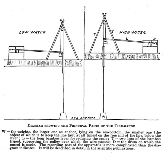
Diagram of a gauge for measuring the tide raising and lowering the sea ice covering McMurdo Sound during the Antarctic winter, from Ernest Shackleton’s Heart of the Antarctic (Philadelphia, 1909).
Besides collecting marine specimens, the explorers also used ice holes to track ocean tides and temperatures during their stay at Hut Point. The tides, they found, rose and fell daily with seasonal irregularities. Water temperature in the sound hovered a degree so below 0°C, or just above freezing for salt water. While the expedition expended sustained effort on such matters, its oceanographic findings fell far below expectations. “The reason is obvious,” Scott explained later, “as the greater part of our time was spent either locked in the ice or cruising in shallow seas; yet, as I look at the vast amount of this work which remains to be done in this area, I cannot but regret that we were unable to effect more.”48
In the shuffle following Gregory’s resignation as science director, Scott assigned meteorology to First Lieutenant Charles Royds, who had only a naval officer’s training in the field. By doing so, Scott did not intend to demote that research. Indeed, he later wrote, “To obtain a complete record of meteorological observations was one of the most important scientific objects of the expedition,” adding that “the prevailing direction of the winds has naturally an important bearing on the general circulation of the atmosphere in the Southern Regions.”49 He simply believed that a good navy officer could keep weather records and wanted as few civilians on board as possible.
The expedition’s instructions called for weather observations every two hours, which required someone to check instruments around the clock. At sea, an officer always stood watch, but at Hut Point this meant special duty. Some meteorological instruments remained on the ship, where everyone lived in relatively warm but smoky conditions; others were moved 120 yards away behind raised, protective screens on the sea ice, where they were subject to the Antarctic climate. Because many of them were manually read, someone had to visit them. Royds made the rounds every two hours from 10 a.m. to 10 p.m. Wilson pitched in at 8 a.m. each day. “Night” duty rotated among other officers and scientists. “On a fine night this was no great hardship,” Scott noted, “but in stormy weather the task was not coveted by anyone.”50 The readings took about twenty minutes in good weather—much more in bad. Ernest Shackleton waxed poetic about the chore in the expedition’s journal:
To be aroused from slumber at the deadest of the night,
To take an observation, gives us all a morbid blight;
How in the name of all that’s blank, can temperatures down here,
Concern those scientific men at home from year to year?
To us alone they matter, for it’s cold enough, Alas!
To freeze the tail and fingers off a monkey made of brass.51
Except during severe blizzards, the expedition kept up this routine for over two years.
Under Royds’s supervision, officers and scientists also regularly noted the temperature, air pressure, and wind conditions at various sites around Hut Point and during sledge trips. “The way he took charge of the meteorology,” Markham said, is “enough to stamp him as a first class worker.”52 Certainly his efforts produced a mass of raw data, but perhaps still smarting from losing their choice for expedition science director, the scientists at the Royal Society were dissatisfied.
The division of duties for analyzing expedition findings gave meteorology to the Royal Society. At the time, scientists disagreed over how Antarctic weather fit into global patterns. All agreed that westerly winds, low air pressure, and high rainfall predominated between latitudes 40° and 60° south—classic cyclonic conditions for the Southern Hemisphere. Some thought these conditions persisted farther south. Others proposed that while westerlies might continue in the upper atmosphere, the low-level pattern was reversed with easterly surface winds, high pressure, and low snowfall across Antarctica—classic anticyclonic conditions. These models carried different implications for interpreting and forecasting weather in the Southern Hemisphere. With the models generating such dissimilar predictions for surface conditions on the Antarctic mainland, scientists hoped that the Discovery expedition could settle the matter. When it didn’t, they blamed the messenger.
“Care was taken to draw up special instructions for working the self-recording instruments in order to secure correct timing and accurate readings,” the Royal Society’s report on the expedition’s meteorological findings began. “Unfortunately, in consequence of changes in the staff, these well-intended efforts failed altogether.” Problems plagued Royds’s use of the new equipment devised for the expedition, forcing the young officer to rely on familiar instruments. This approach could misfire, for instance when he used mercury thermometers (included only as auxiliary equipment) rather than low-temperature ones, to take the regular readings, even though mercury freezes at −38°F, which was often exceeded. Further, the Royal Society report complained, “It was never contemplated that the station barometers would, as a rule, be so exposed to fail because the attached thermometers were not graded below 0°F.” Even Scott realized something was amiss when the snowfall gauge drifted over in blizzards. “Somewhere far beneath the present surface lies the snow-gauge—a fact that makes comment on the utility of that instrument unnecessary,” he noted in his diary after the expedition’s first severe winter storm.53
Royal Society analysts grumbled most about the expedition’s wind and air pressure records, which they had hoped would resolve disputes about the Antarctic climate. Surface winds at winter quarters generally blew from the east or southeast, which fit the anticyclone model for Antarctic weather, but Scott saw this as a local phenomenon caused by nearby mountains. To support his view, Scott pointed to findings from an ambitious thirty-one-day sledge journey by Royds, Bernacchi, and four others southeast across the Ice Barrier, which they made for the express purpose of obtaining meterological and magnetic readings unaffected by land.
Royds’s records from this journey reported winds from the southwest, which supported the cyclone model for Antarctica’s climate. The Ice Barrier, however, is a featureless plane. Royal Society analysts determined that if Royds recorded the raw compass readings for these winds without correcting for variations caused by the region’s skewed magnetic field, his records actually showed the wind blowing from the east, as at Hut Point. When pressed on the matter, Royds equivocated before ultimately affirming that he had made the correction. Scott backed his man, but proponents of the anticyclone model expressed their doubts. “How are we to account for the existence of a steady south-westerly current within a few miles of the ship,” the Royal Society report asked, while “at the ship, although quite open and unsheltered towards the south-west, easterly winds were experienced almost exclusively?”54
Air pressure readings from the sledge journey could have helped to resolve the dispute, but again Royds’s methods fell short. He found lower pressure as he traveled south over the Ice Barrier, which fit the cyclone model, but he did not adjust for changes in altitude. The Ice Barrier looked “level” to him.55 One Royal Society analyst calculated that if the Ice Barrier sloped only two feet per mile toward the sea (“which is probably well within the actual amount”), then the relative pressure, corrected for altitude, actually increased southward.56 As recorded in the Royal Society report, Scott responded by observing, “The staff possessed no means of discriminating between the influence on the barometer of the varying conditions of atmospheric pressure, on the one hand, and the difference in altitude on the other.” By saying so, he conceded that the findings were useless. “It is curious,” the Royal Society report stated, “that endeavors to reach, by two separate crucial tests, a definite conclusion upon this interesting point, as to whether the easterly wind at winter quarters is a local wind or a true general wind implying a high pressure to the south, fail through very slight omissions in the observations or the records.” Gregory would have done better, the report all but said.57
In 1907, Shackleton returned to McMurdo Sound on the Nimrod determined to best Scott’s Discovery expedition in every respect—including science. In Edgeworth David, he had a science director and senior geologist with research credentials and expedition experience to match Gregory’s. With Douglas Mawson and Raymond Priestley, he gained young researchers destined to establish lasting reputations in science. The expedition’s second-in-command, naval reserve officer Jamison Adams, served also as its meteorologist. On the advice of Challenger’s John Murray and polar explorer William Speirs Bruce, Shackleton chose the hard-working, self-educated scientist James Murray for biology. An adventuresome twenty-year-old heir to a vast landed estate, Baronet Philip Brocklehurst, went along as assistant geologist in return for a £2,000 donation to the expedition. A product of the merchant marine, Shackleton cared little about navy discipline and welcomed civilians on board. “He had assembled a powerful scientific team almost despite himself,” historian Beau Riffenburgh concluded.58 Without the scientific pretensions that hobbled the big-budget, publicly funded Discovery expedition, Shackleton’s low-cost, privately financed enterprise easily exceeded expectations.
In the Nimrod expedition, Murray filled the role of Discovery’s Hodgson and used many similar techniques. Assisted by Priestley, the expedition’s junior geologist, he spent much of the winter trapping marine specimens through holes in the ice and dredging the bottom along tide cracks. “It rarely happened that we found the cracks open,” Murray wrote. “Usually they were filled with new ice to a depth of 6 inches or a foot, and it was by hard labour with ice-picks and crow bar that we got a sufficient length open to serve for dredging. . . . To avoid dredging too frequently over the same ground it was necessary to cut trenches in the ice alongside the ends of the rope and at right angles to the line joining the two ends. In these trenches the rope could be shifted a yard or so at each time of dredging.” The dredge and trap brought up vast numbers of the same few species: bivalves, snails, corals, starfish, sea urchins, large worms, sponges, sea anemones, and five types of big-headed fishes. “The sea bottom here appears to be covered by a continuous carpet of living things,” Murray observed.59
Murray’s collection gave scientists some appreciation of the diversity and distribution of Antarctic marine life. “Though our location at Cape Royds was only twenty miles north of the Discovery winter quarters,” he wrote, “the local conditions differ very considerably. The temperature appears to be usually ten degrees or more (Fahrenheit) higher than at Hut Point. Being close to the spot where McMurdo Sound opens into the Ross Sea, we had open water close by throughout the year.” This kept Murray near shore. Most of his specimens came from either a shallow, sheltered bay with a black-mud bottom or a steep bank with strong currents. “The collections differed a good deal in their composition,” he wrote of his haul from the two sites, but not so much as the disparity between what he found and what Hodgson had reported. “This amount of difference between collections made at stations only twenty miles apart is very considerable. It is more important that one of our most abundant shallow-water species (Yoldia eightsi) did not occur at all at Hut Point.”60
In other oceanographic and meteorological activities, the Nimrod expedition attempted to copy or improve on its predecessor. It tow-netted for plankton in the Ross Sea, charted tides and currents in McMurdo Sound through the ice, recorded weather conditions every two hours, and reported its findings in the same sort of heavy, bound volumes that memorialized the Discovery’s voyage. In an implicit reference to Royds’s missteps, Shackleton noted in his popular account of the expedition that his men used spirit thermometers to measure temperatures below the freezing point of mercury and devised a stove-pipe gauge to measure snowfall in blizzards. For an expedition known and remembered mostly for Shackleton’s dramatic dash toward the South Pole, its members devoted an extraordinary amount of time and effort to scientific fact-gathering. Science made the overall enterprise respectable in Edwardian England and helped secure Shackleton’s knighthood.
The expedition’s ascent of Mount Erebus showed how science gave meaning to adventure. Rising nearly 12,500 feet above Ross Island, Erebus not only towered over the explorers in their winter quarters at Hut Point and Cape Royds, tempting them to climb it, but also served as a high-altitude weather vane. “The proximity of Mount Erebus was a great stroke of luck,” Scott wrote, “as the smoke of that volcano gave us an indication of the direction of the upper air currents.” His expedition’s Erebus smoke observations—368 in total, with three out of four showing winds from the southwest quadrant—helped convince him that easterly surface winds were a local aberration. Yet both models of Antarctic weather allowed for westerly winds spiraling inward toward the pole at upper altitudes, and proponents of the low-level anticyclone model noted that the expedition’s cloud observations suggested a gradual shift from easterly and southerly low-and mid-level winds to higher westerlies. “The drift of the Erebus smoke would represent the motion of the air at a level approximately midway between the two,” a Royal Society analyst noted.61 During the Discovery expedition, Scott considered but rejected an ascent of Erebus. Shackleton’s men stole that glory in the name of science.
The seven-day climb occurred in March 1908, after the Nimrod expedition had settled into winter quarters but before the full force of winter hit. “The observations of temperature and wind currents at the summit of this great mountain would have an important bearing on the movements of the upper air, a meteorological problem as yet but imperfectly understood,” Shackleton explained, “and apart from scientific considerations, the ascent of a mountain over 13,000 ft. [sic] in height, situated so far south, would be a matter of pleasurable excitement.”62 He chose David, Mawson, and Forbes Mackay to summit, with Adams, Brocklehurst, and Eric Marshall in support. In the end, all attempted to summit despite the support party’s lack of knapsacks and climbing gear.
Although Cape Royds sits on the flanks of Mount Erebus only seventeen miles from the summit, the climb was complicated by a steeply rising grade, bitter cold, and inadequate preparations. “At one spot,” Shackleton wrote, “the party had a hard struggle, mostly on their hands and knees, in their effort to drag the sledge up the surface of smooth blue ice.” At others, deep sastrugi, or wind furrows in the crusted snow, made pulling uphill almost impossible. On day three, the climbers exchanged their 560-pound sledge for 40-pound knapsacks—with the support party improvising packs. “Some of us with our sleeping bags hanging down our backs,” David wrote, “resemble the scorpion men of the Assyrian sculpture: others marched with their household goods done up in the form of huge sausages.”63 That night, gale-force southeast winds pinned them in collapsed tents for thirty-two hours at nine thousand feet, which was enough to convince them that surface-level blizzards could reach high into the atmosphere. Climbing in misfit ski shoes, on his twenty-first birthday Brocklehurst began developing a serious case of frostbite that later cost him a toe. He remained behind on the fifth day while the others pushed on to the summit. Near the top they entered a fairyland of whimsically shaped, hollow ice-mounds formed when hot steam rising from volcanic vents hit the frigid Antarctic air. No one had seen such a sight; it took David to explain it.
The party reached the volcano’s rim on the morning of the sixth day. “We stood on the verge of a vast abyss,” David and Adams wrote. “Mawson’s angular measurement made the depth 900 ft. and the greatest width about half a mile.” With their injured companion waiting at the last campsite, the climbers quickly headed back down. “Finding an almost endless succession of snow slopes below us, we let ourselves go again and again in a series of wild rushes,” David recalled.64 Tossing their packs ahead and using ice-axes like rudders, they slid over halfway down the mountain by 10 p.m., to where they had left the sledge. Marshall described the plunge: “Pushing bag, glissading, following up, recovering it, dragging, shoving, soaked through.” All six climbers stumbled into winter quarters before noon on the next day. “Bruised all over,” Marshall wrote, “nearly dead.”65 They were greeted with champagne and Quaker Oats. Along with reaching the South Magnetic Pole and Shackleton’s Farthest South, their ascent became one of the expedition’s three best-known feats. “Fierce was the fight to gain that bright height,” Shackleton wrote in a poem commemorating the event.66
The findings of the Discovery and Nimrod expeditions yielded a consensus understanding of Antarctic weather. Reports of persistent easterly and southeasterly winds at Hut Point and Cape Royds bolstered the view of a low-level anticyclone characterized by relatively high pressure and generally low precipitation. Between about five thousand and fifteen thousand feet, David and Adams reported that the wind typically shifted more to the south. “This is the return current of air blowing back from the South Pole towards the Equator,” they asserted.67 Above fifteen thousand feet, they detected the northerly winds that fed the polar high pressure and completed the Southern Hemisphere’s weather cycle.
Summarizing these findings in a later report, David and Priestley depicted the region’s general weather pattern as a “great Antarctic high-level cyclone overlaying the permanent anti-cyclone.” This combination represented the predictable pattern if the area was covered by a low ice sheet rather than a high plateau, they noted: an upper-level cyclone circulating air south and a lower-level anticyclone cycling it back north. The actual mix of local surface winds “is much complicated by the rock and ice dome of the Antarctic taking the place of so much of what otherwise would have been the lower part of this anticyclone.” The pole, they wrote, “appears to be the eye of the great anticyclone.” Turning to the upper levels, they added, “Some have doubted the existence of this cyclone, but from the fact that whenever there was an extra powerful eruption of Erebus, so that its steam cloud was carried to an altitude of above 20,000 feet, we invariably noticed that it was caught by a powerful W.N.W. or N.W. current, we are inclined to believe that this huge permanent cyclone really exists.” All this, they wrote, combine with the steep grade in slope and temperature from the Polar Plateau to the sea and the vast extent of the surrounding ocean “to make the Antarctic the home of winds of a violence and persistence without precedent in any other part of the world.”68
Diagram of the plume from an eruption of Mount Erebus suggesting the impact of upper-level wind currents, from Ernest Shackleton’s Heart of the Antarctic (Philadelphia, 1909).
For Nimrod’s naturalists, Mount Erebus provided clues to begin resolving the puzzles posed by the continent’s extraordinary weather. “Not only had we the great cone of Erebus to serve as a graduated scale against which we could read off the heights of the various air currents,” David and Adams wrote, “but we also had the magnificent steam column in the mountain itself, which by its swaying from side to side indicated exactly the direction of movement in the higher atmosphere.” When violent eruptions sent the steam over twenty thousand feet, “it penetrated far above the level of a current of air from the pole northwards, so that its summit came well within the sweep of the higher wind blowing in a southerly direction,” the two researchers noted.69 Firsthand experience with sastruga patterns and wind conditions on Erebus reinforced their observations of cloud and steam movements. Much work remained, but the Antarctic sea and sky finally began to fit into global patterns. Alluding to the mountain where Moses first saw the Promised Land, David and Adams concluded, “It would be hard to overestimate the scientific importance of knowledge of the meteorological conditions obtained at Erebus. Erebus is the Pisgah of the meteorologist.”70
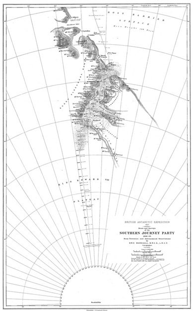
Southern Journey of Ernest Shackleton, Jameson Adams, Eric Marshall, and Frank Wild (1908–9), from Shackleton’s Heart of the Atlantic (Philadelphia, 1909).