ICE FEATURED PROMINENTLY IN THE THINKING OF all early Antarctic explorers. James Cook returned from his 1772–75 circumnavigation of the south polar region with the saga of a Great Southern Ocean blockaded by a field of sea ice. “This immense field,” he wrote, “was composed of different kinds of ice; such as high hills; loose or broken pieces packed close together, and what, I think, Greenlandmen call field-ice. A float of this kind of ice lay to the S.E. of us, of such extent that I could see no end to it, from the mast head.” From his 1839–43 voyage beyond that blockade, James Clark Ross added the image of a Great Ice Barrier extending hundreds of miles across the southernmost water approach to the pole: “It is impossible to conceive a more solid-looking mass of ice; not the smallest appearance of any rent or fissure could we discover throughout its whole extent, and the intensely bright sky beyond it but too plainly indicated the great distance to which it reached to the southward.” The explorers who followed spoke of pack ice, land ice, ground ice, drift ice, icebergs, ice caps, ice falls, ice floes, floebergs, and glaciers. Clements Markham opened the Discovery expedition’s scientific manual with a glossary of “Ice Nomenclature” that included over seventy such terms. In a 1900 address to the RGS, he listed “glaciation” as a primary field for “geographical discovery.”1
In Britain, however, the lure of ice did not begin with Antarctic exploration. The drive to map the world’s polar regions and bring them within the realm of scientific knowledge started in the north. The Franklin searches brought it to a head during the 1850s, but interest in such work was growing even before Erebus and Terror became locked in the Arctic ice, and it continued long after Leopold McClintock ascertained the lost expedition’s fate. These episodes simply added to the allure.
These were heroic times in Britain, or at least a time in search of heroes, and polar firsts filled the bill. John Franklin’s nephew Alfred, Lord Tennyson, Britain’s poet laureate from 1850 to 1892, captured the spirit in verse. His epitaph for his uncle in Westminster Abbey read:
Not here! the white North has thy bones; and thou
Heroic sailor-soul,
Art passing on thine happier voyage now
Toward no earthly pole.2
The explorers themselves read Tennyson. Edward Wilson, a Christian ascetic and recovering consumptive, drew comfort on his polar journey from In Memoriam. It “makes me feel that if the end comes to me here or hereabout,” he wrote from the base of Beardmore Glacier in 1911, “all will be as it is meant to be.” When he spoke of humanity in this work, Tennyson seemed to speak of Wilson in particular: “Such splendid purpose in his eyes, / Who rolled the psalm to wintry skies.” Wilson’s sledge-mate and commander, the driven but self-doubting Scott, an introspective agnostic, surely noted the poem’s portrayal of the human condition “as futile, then as frail!”3
The wanderlust depicted by Tennyson in Ulysses also spoke to the explorers and their conception of science: “To follow knowledge like a sinking star, / Beyond the utmost bound of human thought.” And it added, “To sail beyond the sunset, and the baths / Of all the western stars, until I die.” At the 1906 RGS ceremony honoring Roald Amundsen for completing the Northwest Passage, Nansen applied the final line of this poem to his Norse colleague: “To strive, to seek, to find, and not to yield.” Many then saw a crystalline sea or field of ice as a fitting stage for humankind’s heroic struggle against fate, nature, or futility. Markham extolled the Discovery expedition for giving navy officers like Scott “an opportunity to do battle with and to conquer the Antarctic ice, as our navy always conquers.” In an age of Tennyson and Darwin, of “Nature, red in tooth and claw,” science gave meaning to exploration, and glaciology became a purposeful part of polar expeditions.4
The very nature of ice posed questions. It was only in the late 1700s that chemists resolved the composition of water and determined the large amount of heat required to make ice melt. Differences in the types, colors, viscosities, and composition of ice puzzled physicists into the twentieth century. Sea ice and land ice raised separate issues, and distinguishing the former from floating land ice or compressed cakes of snow could baffle field researchers.
Ice sheets and glaciers compounded the problem. During the mid-nineteenth century geologists first recognized both the global extent of former ice sheets and role they played in shaping terrain. Although evidence of glacial scouring and transported debris persuaded them that vast ice sheets had once covered Europe and North America, they could not agree on how these seemingly solid bodies flowed like slow-moving liquid. Some thought that melting at the base caused the movement, others attributed it to gravity, and still others saw plasticity as a property of glacial ice. “Any mechanical theory of glaciers must be more or less imperfect which does not explain the remarkable veined or ribboned structure of the ice,” an 1898 essay on the topic noted.5 Greenland and the Alps offered some opportunity to study these questions, but nothing like the opening provided by Antarctica, where conditions resembled those of the ancient ice ages. Antarctic glaciers and ice sheets, researchers hoped, could shed light on those earlier ages and their associated climate changes.
Before his resignation, Discovery’s initial science director, J. W. Gregory, outlined an ambitious program of ice research for Scott’s first expedition. “Members of the Expedition will have ample opportunities for the observation of Antarctic ice,” he wrote, “but, that the observations may be scientifically useful, they must be systematic, and directed along certain definite lines.” He proposed that the expedition begin by examining the icebergs and sea ice encountered on the way south. “The characteristic Antarctic icebergs are of the flat-topped variety, which in the Arctic region have been called floebergs from the belief that they were formed . . . by the freezing of layer after layer [of sea water] to the underside of the floe,” he noted. The characteristic Arctic iceberg, in contrast, has a pinnacled top and calved from the sea edge of land ice. Which of these sources give rise to Antarctic bergs, he continued, “is still open. It can be tested by determining, in the case of Antarctic floebergs, the amount of salt in different layers.” Ice floes themselves should be measured, he added, and their maximum thickness recorded.6
Turning to land ice, Gregory stressed the importance of studying both glaciers and the interior ice sheet. “That glaciers flow like rivers was discovered long ago,” he noted, “but the cause and mode of this movement is still an open question. Many theories have been proposed in explanation of this, the most important of which are founded, directly or indirectly, on the study of the minute structure of glacier ice. . . . The size, shape and optical arrangement of the glacier grains should therefore be carefully studied.” Gregory also urged that the explorers try to measure “the thickness of the Antarctic ice-sheet” on Polar Plateau. Estimates ranged from sixteen hundred feet to twenty miles, though anything over a few miles, he noted, was “not easy to reconcile with the known properties of ice.”7 He suspected that its greatest depth lay behind Victoria Land’s coastal mountains and that the ice descended southward “slowly across the Pole to the shore of the Weddell Sea,” where it discharged into the sea. Gregory called as well for detailed observations of glacial debris, deposits, scouring, and melting patterns. “Evidence as to whether the ice in Antarctic regions is now at its maximum extent, or whether it has anywhere retreated, should be carefully sought.”8
The Great Ice Barrier raised an added set of questions. Nothing like it, Gregory noted, existed anywhere else on earth, and its origin “is still unsettled.” Since Ross discovered it, many commentators had viewed the Ice Barrier as the level northward extension of a polar ice sheet, anchored on land in the south and pushed out over the Ross Sea, where it floated to a depth of more than a thousand feet. Others countered that it might either rest on the bottom of the southern Ross Sea basin or constitute the broad snout of a northward-flowing glacier. Returning from the Southern Cross expedition in 1900, Louis Bernacchi added his idea that the barrier was simply a long, narrow ice tongue bisecting the Ross Sea from west to east, the outflow of a Victoria Land glacier. Land might or might not exist farther south, Bernacchi told the RGS shortly before Discovery sailed, “but I do believe that there is an open sea between the southern side of the great ice-barrier and that land, if it exists.”9
Gregory and others hoped the Discovery expedition would resolve these questions by sending parties across the Ice Barrier, recording its movement and looking for any detectable slope. In part to test Bernacchi’s idea, Joseph Hooker, the last surviving member of Ross’s expedition, proposed that the ship carry a tethered hot-air balloon so that the explorers could look across the Ice Barrier from its seaward edge. Like Ross, Hooker thought that ice extended to the South Pole. “Of course, the great interest of the voyage and observations is that great ice-barrier,” he told the RGS. From the balloon—inflated only once at an inlet in the Ice Barrier—Scott, Shackleton, and three other Antarctic aeronauts saw nothing to the south but what Shackleton described as “league upon league of whiteness.” The Ice Barrier was a true ice sheet or shelf flowing from the south, not an ice tongue extending from the west, but it still might originate on land short of the pole. In a poem composed after his balloon ride, Shackleton asked of the Ice Barrier, “Shall we learn that you come from the mountains? Shall we call you a frozen sea?” Either explanation remained plausible.10
From these ice studies, expedition organizers hoped to learn about more than local conditions. “The study of Antarctic ice is desirable,” Gregory wrote, “from the evidence it may yield as to the conditions of the period when some form of ice agent deposited a vast sheet of clay, sand and gravel over much of North-western Europe, including most of the British Isles.” The deposits could have come from icebergs calved from a vast network of ancient glaciers or from a massive ice sheet covering the entire region. “No evidence in support of the latter hypothesis is given by Arctic ice,” Gregory noted, “but the great Antarctic ice barrier may conceivably be doing what some geologists assure us that the Scandinavian ice-sheet did in ‘the Great Ice Age,’ and what other geologists tell us is impossible.”11 If so, the lessons learned from Antarctic ice could carry global significance. The Duke of Argyll, a leading British advocate of the theory of a geologically significant former ice age, made this point in promoting the Discovery expedition. The most discussed and difficult geological questions of the day, he asserted, related to how moving ice sheets affect land. “These questions, and a hundred others, have to be solved by Antarctic discovery; and until they are solved we cannot argue with security on the geological history of our own temperate regions.”12
Gregory’s resignation hobbled the expedition’s efforts to study Antarctic ice, much as it hampered work in geology. As a field geologist, Gregory had cut his teeth studying the impact of glaciers on the American Rockies. He pursued similar research in the Alps and participated in a major Arctic expedition, where he studied both sea and land ice in the Spitzbergen region. “His ice experience,” Gregory’s chief supporter on the Royal Society’s Antarctic Committee declared, was “of the highest importance.”13 In replacing him, Scott made no effort to secure someone with expertise in glaciology. Responsibility for the discipline fell on the expedition’s substitute geologist, Hartley Ferrar, who was barely qualified in his own field and had never worked in polar or alpine regions. Fortunately, as a last-minute fill-in to make magnetic observations, Scott signed on Bernacchi, who had interest in the Ice Barrier from his experience on the Southern Cross expedition and would champion its study.
On the voyage through the Southern Ocean and into the Ross Sea, expedition members made regular observations of icebergs. Charles Royds spotted the first one on January 2, 1901, Wilson noted. “Soon Skelton sighted another and I a third and then there were never less than 4 or 6 in sight at once.” They counted, measured, and photographed them. Wilson sketched many. “The nature and origin of the southern iceberg have always been a subject of some mystery,” Scott wrote. Unlike those in the North Atlantic, he observed, “they have all a flat top and wall sides, and appear to have broken quietly away from some huge sheet of ice.” Some were much larger than any in the north. “The largest berg we saw was aground off King Edward’s Land,” Scott wrote in some awe, “and we estimated it as about seven miles long and 200 feet high.” From their size, shape, location, and movement, the explorers concluded that Antarctic icebergs detached either from the Great Ice Barrier, which Shackleton hailed as the “mother of mighty icebergs, those Kings of the Southern Seas,” or from one of the region’s floating glacial ice tongues. Given these sources, Scott commented, “I see no reason why their length should be limited.” Unlike Arctic floebergs, they were composed of salt-free ice that clearly originated as snow.14
Two days after first sighting icebergs, the explorers entered the sea-ice pack. The expedition’s second-in-command and only member with Arctic experience, Albert Armitage, wrote, “To one accustomed to the ice-pack of the Northern seas, this Southern ice presented a most extraordinarily level appearance. It seemed to me as though large fields of ice had been formed in protected places, and then broken up.” Scott added, “The nature of the pack seemed to change every few hours; sometimes the floes were more easily pushed aside and broken, at others they flew apart at the first shock; at times the prow entered deep in a floe before the first crack appeared, at others it seemed to make little impression.”15
The study of sea ice continued after the explorers left the pack. “During our long stay in our winter quarters,” Soctt wrote, “we were able to observe to some extent the breaking-up and clearing of the Ross Sea, which goes to form this line of pack.” Based on data collected at field sites, Ferrar computed that salt water in the Ross Sea froze to a depth of eight feet during winter, broke up by summer, and floated north to create the surrounding pack. “The upper two inches consist of plates, a quarter of an inch across and a sixteenth of an inch think, which lie horizontally, and only gradually do these give place to the sheaves of vertical fibers which make up the greater mass of the ice,” he reported. “The salinity seems to depend more upon the rate of freezing than upon the depth or distance from the surface.” Ferrar found sea ice much less salty than sea water. Further, once the sea froze over, snow accumulated on top and pushed down the ice, which melted from the bottom so that at some sites all the original sea ice was totally dissolved by spring, leaving only ice from the snow.16
After exiting the pack and crossing the Ross Sea, Discovery sailed back and forth for nearly a thousand miles along the Ice Barrier’s face before entering winter quarters. Observations made during this passage established that, at least at its sea edge, the Ice Barrier floated and was calving rapidly. Plotting Discovery’s route along the barrier’s front against Ross’s path in 1841, Scott found that the sea edge had retreated by as much as thirty miles in sixty years. “We had sailed continuously over ground which in [Ross’s] day had been covered with a solid icesheet,” he noted. Sounding lines found sufficient depth to float ice of the barrier’s height and drew up pebbles from the seabed, suggesting that the Ice Barrier’s underside dropped rock debris scoured from the Antarctic mainland. “The part that has broken away must therefore have been water-borne, and this at least shows the possibility of the ice-sheet being afloat for an almost indefinite distance to the south,” Scott reasoned. Further, he observed, when Discovery tied up to the barrier, “although we had evidence of considerable tidal movement, the ice rose and fell with the ship.”17 The explorers later found added evidence that the Ice Barrier floated by studying its movement at tide cracks where it abutted land in the west.
After Discovery anchored at its winter quarters, where it remained frozen in place from February 1902 to February 1904, none of the explorers made ice a primary subject for research. Indeed, after one summer passed without McMurdo Sound breaking up, their main concern with sea ice was freeing the ship from it. Nevertheless, Scott’s Southern Sledge Journey in the summer of 1902–3 demonstrated that the Ice Barrier extended for at least three hundred miles southward, with no end in sight. “It was a surprise to everyone, and not least to ourselves, to find that our long journey to the south was made without a rise of level,” Scott noted. “I do not see that there can be any reasonable cause to doubt that the Great Barrier ice-sheet is afloat at least as far south as we travelled.” That same summer, Armitage’s Western Sledge Journey gave humans their first glimpse of the earth’s largest ice sheet—the Polar Plateau. “There was nothing but an undulating white surface,” Armitage wrote, “we were, in fact, on the summit of the ice-cap in that portion of Victoria Land, at a distance of 101 statute miles from the coastline.”18 Throughout the expedition, while focusing his efforts on geology, Ferrar periodically checked the depth, structure, and salinity of sea ice at sites near winter quarters. The ship’s confinement brought an unexpected third season of sledging, giving the explorers a chance to conduct three additional journeys that shed light on Antarctic ice.
Bernacchi talked Scott into the first of these ventures. Perhaps still nursing his idea concerning open water in the south, Bernacchi argued that despite its first year’s efforts, the expedition had learned little about the interior of the Ice Barrier. Scott’s Southern Party had merely found that it extended level for some three hundred miles on its western edge. Bernacchi proposed sledging diagonally across the Ice Barrier in a southeasterly direction from Ross Island. Scott tapped Royds to lead the party, which included Bernacchi and four from the ship’s company. Man-hauling two five-hundred-pound sledges, they left on November 10, 1903, with instructions to determine whether the Ice Barrier continued level toward the east and to return in time to help free Discovery from the ice for the voyage home. “It was a short journey, as it only occupied thirty days, and for those who took part in it it could not be otherwise than monotonous and dull,” Scott wrote, “yet it deserves to rank very high in our sledging efforts, for every detail was carried out in a most thoroughly efficient manner.”19 Bernacchi used the occasion to take a regular series of highly accurate magnetic readings, far from disturbances caused by land or the ship’s metal fittings.
Sledging southeast for 178 miles, or about one-third of the way across the Ice Barrier, Royds’s party found nothing except an icy, undulating surface with no noticeable net rise. Scott called this “a negative but highly important result” and recognized that it came at a cost. “The party went on a very short food allowance,” he wrote, “and day after day found themselves marching over the same unutterably wearisome plain.” Bernacchi added, “This dragging was very heavy on account of the bad surface, and the temperature was generally below zero, with a strong wind and drifting snow.” Everyone felt real hunger. “‘Food, food, food’ is what one thinks about,” Bernacchi noted. “We, of course, saw no new land, nothing but the barren, level surface of the barrier.” Years later, he still remembered the “ghastly business” of relieving himself on a featureless plain in high winds and blowing snow. “There are no facilities within the tiny tent; latrines are impossible,” he observed, “so there remains the open snow spaces.” After loosening layers of clothing, he explained, “the rest is a matter of speed and dexterity, but invariably the nether garments are filled instantly with masses of surface-drifting snow.” This snow caused extreme discomfort as it melted. “Low temperatures, painful though they may be, are not serious, but there have been cases of quite unpleasant frostbite.”20
Even as Royds’s party struggled across the Ice Barrier to the southeast, a sledging party led by Michael Barne made a dramatic discovery in the south. Scott had sent Barne’s party south in October 1903 to explore the junction between the Ice Barrier and the South Victoria Land coast. “Ill fortune dogged this party from the start,” Scott reported. “They were hampered with continual gales from the south, and again and again had to spend long days in their tents.” When Barne and his men tried to cross over the divide separating the Ice Barrier from the coast to study the land, they were blocked by the same sort of deep crevasses and steep hummocks that had stopped Scott from making a similar traverse during his Southern Sledge Journey. “From their observations,” Scott concluded, “it is doubtful whether a sledge party could ever cross it unless they were prepared to spend many weeks in the attempt.” With no such time, Barne’s party turned back in late November having traveled about 150 miles from winter quarters, with little more than a detailed map of the coastline to show for the effort. On the return trip, however, Barne noticed that a well-marked supply depot placed on the Ice Barrier over thirteen months earlier had moved 608 yards seaward. “Almost accidentally we obtained a very good indication of the movement of the Great Barrier ice-sheet,” Scott reported.21
The season’s signature event—Scott’s Western Sledge Journey—began and ended in Victoria Land’s coastal mountains, but the middle was epic ice. In November 1903, after retracing Amitage’s route up nine thousand feet in one hundred miles to the Polar Plateau with five others and, for most of the way, Ferrar’s three-person geology team, Scott set out across it with two navy bluejackets, Edgar Evans and William Lashly, whom he viewed as the ablest sledgers in the group. He depicted Evans as “a man of Herculean strength, very long in the arm and with splendidly developed muscles.” Scott, who was a heavy smoker and felt its effects, marveled at Lashly’s physical discipline and massive chest. The thirty-six-year-old navy stoker, he noted, “had been a teetotaler and non-smoker all his life, and was never in anything but the hardest condition.”22 No one had ventured onto the Polar Plateau before. With these men, Scott tried to cross it: the highest, coldest, driest, and largest ice sheet on earth. Perhaps more than anything else in Antarctica, this utterly unique mass of ice, which holds over half of the earth’s fresh water, aroused the curiosity of glaciologists. Scott’s account introduced them to it.
Scanning the ice westward from the summit of the coastal mountains, Scott had some notion of what to expect. “I do not think it would be possible to conceive a more cheerless prospect than that which faced us . . . on this lofty, desolate plateau,” he wrote. As he had done in the Southern Sledge Journey, he again faced crossing a seemingly endless plain of ice, this time without a dramatic coastline to follow. “Yet before us lay the unknown. What fascination lies in that word! Could anyone wonder that we determined to push on?” Still, conditions proved worse than he expected. The weather was colder than any sledge party had yet endured for such a long period. “Regularly each night, when the sun was low in the south, the temperature fell to −40° or below, whilst during the marching hours it rarely rose much above −25°,” Scott noted. “If the thermometer can fall to −40° in the height of summer, one can imagine that the darker months produce a terrible extremity of cold.”23 He had expected the high altitude and cold temperature to bring clear skies, but a heavy overcast sometimes forced the party to stop midday. “We could not see a foot in front of us,” Lashly complained at one point. “When you get a gray day up there you can see nothing,” Scott added. “From under your feet to the zenith there is nothing in sight.” Further, near the end of the return trip, an icy snowfall hampered sledging.24
A fierce westerly wind made matters worse. “It has cut us to pieces. We all have deep cracks in our nostrils and cheeks, and our lips are broken and raw; our fingers are also getting in a shocking state,” Scott wrote after one week on the plateau. “We can do nothing for this as long as we have to face this horrid wind.” He had determined from the outset to march due west until the end of November and then turn around: two weeks out and two weeks back. The stopping place was purely artificial—there was nothing to see at any point except more of the same—yet Scott held to it. The men carried just enough food and fuel for the planned trip, a tactic that proved problematic near the end when overcast skies and snow slowed their return. Both the fuel and Scott’s tobacco ran out, causing irritation all around. From his experience in the howling wind and by observing drift patterns in the surface, Scott concluded, “The wind blows from west to east across this plateau throughout the winter, and often with great violence.”25
Beyond reports on wind and weather, Scott brought back a vivid picture of the plateau’s surface. Using a fluidless barometer, he determined that the net altitude remained nearly constant at some nine thousand feet across the two hundred miles of ice sheet that his party crossed. The surface itself featured broad undulations, averaging three to five miles from rise to rise, overlaid by a pattern of wavelike sastrugi running parallel to the prevailing wind. “The summits and eastern faces of undulations were quite smooth with a very curious scaly condition of surface, whilst the hollows and the western faces were deeply furrowed with the wind,” Scott reported. “For long stretches we travelled over smooth glazed snow, and for others almost equally long we had to thread our way amongst a confused heap of sharp waves. I have rarely, if ever, seen higher or more formidable sastrugi.” He compared the journey to sailing on “a small boat at sea: at one moment appearing to stand still to climb some wave and at the next diving down into a hollow. It was distressing work, but we stuck to it, though not without frequent capsizes.” Otherwise, the surface remained constant, with none of the crevasses and hummocks that marked glaciers or sea ice. “Could anything be more terrible than this silent, wind-swept immensity?” Scott asked in his diary.26
The gravest threat to life or limb came as the party left the plateau. In rising winds, the men lost control of the sledge on the first icefall descending to the glacier and were jerked forward by their harnesses. “We all three lay sprawling on our backs and flying downward with an ever increasing velocity,” Scott reported. “At length we gave a huge leap into the air, and . . . came down with tremendous force on a gradual incline of rough, hard, wind-swept snow.” Fifteen minutes after resuming their march and still tethered to the sledge, Evans and Scott stepped into a crevasse. “Personally I remember absolutely nothing,” Scott wrote, “until I found myself dangling at the end of my trace with blue walls on either side and a very horrid-looking gulf below.” Evans dangled nearby. The sledge tottered on the edge, twelve feet above them, with only Lashly’s extreme effort keeping it from taking everyone down to certain death. “It is some time since I swarmed a rope, and to have to do so in thick clothing and heavy crampons and with frost-bitten fingers seemed to me in the nature of the impossible,” Scott noted, but he managed. After securing the sledge, Scott and Lashly pulled up Evans. “We all agreed that yesterday was the most adventurous day in our lives,” Scott wrote in his diary a day later, “and none of us want to have another like it.”27
Descending from the Polar Plateau, Scott’s party discovered the Dry Valley, which clearly showed one glacier in full retreat. Having seen the vast expanse of ice on the plateau, and now noting signs of glacial scouring and debris high on the valley walls above the descending glacier, Scott became convinced that the polar ice sheet was shrinking. “At a comparatively recent period,” Scott reported to the RGS, “the whole glaciation of the region was vastly more extensive than it is today.” Similarly Ferrar, in his report on Antarctic geology, repeatedly referred to “the recession of ice,” “diminution of ice,” and “a former greater ice supply” as characteristic of the region.28
The expedition’s finding that the Ice Barrier’s edge had retreated since Ross’s day supported this hypothesis. “It is evident,” Scott wrote, “that when the Southern glaciation was at a maximum, when the glacier valleys were filled to overflowing, and when the great reservoir of the interior stood perhaps 400 or 500 feet above its present level and was pouring vast masses of ice into the Ross Sea, the Great Barrier was a very different formation from what it is at present.” He saw it as a remnant of an ice sheet that once filled the Ross Sea basin and extended into the Southern Ocean: “There are abundant evidences of its great enlargement; granite boulders were found on Cape Royds and high on every volcanic island in our neighbourhood; on the slopes of Terror, Dr. Wilson found morainic terraces 800 feet above the present surface of ice; Mr. Ferrar showed that nearly the whole of the Cape Armitage Peninsula was once submerged; and, in fact, on all sides of us and everywhere were signs of the vastly greater extent of the ancient ice-sheet.”29
To Scott, present-day Antarctica and its current ice sheet resembled prehistoric northern Europe and its former ice sheet. Already the Antarctic ice pack appeared to dissipate entirely each summer. The warming might continue. “It is strange to think,” he concluded, “that there may be a season in the year when the enterprising tourist steamer may show its passengers the lofty smoke-capped form of Mount Erebus as easily as it now does the fine scenery of Spitzbergen.”30
The Nimrod expedition picked up where Discovery left off in examining the striking retreat of Antarctic ice. Primed by the comments of Scott and Ferrar, Shackleton’s geologists, Edgeworth David, Douglas Mawson, and Raymond Priestley, found evidence of diminished ice everywhere they looked. It became their all-purpose explanation for such disparate observations as dry valleys, dead glaciers, raised beaches, stranded moraines, isolated ice fields, granite erratics on volcanic mountains, glacial scouring high on rounded valley walls, and Victoria Land’s broad coastal shelf. Despite enduring extreme cold and harsh blizzards, these geologists repeatedly found signs of a shrinking ice sheet on their northern and western sledge journeys and ascent of Mount Erebus.
“Certainly the Antarctic ice sheet is decreasing rapidly,” David and Priestley stated in the expedition’s official report, “and this ice shrinkage has been general.” Describing their own observations, they wrote in 1910, “The evidence collected by the Northern and Western parties of formerly far more intense glacial action than at present extends from Mt. Nansen to the Ferrar Glacier, a distance of about 200 geographical miles.” Extending their account to cover the entire Ross Sea basin, they added that expedition members found erratics high on Mount Bird, sixty miles north of the Ice Barrier’s front; on Mount Hope, near Beardmore Glacier far to the south; and on Mount Erebus in the east. In a 1909 list of his expedition’s contributions to geology, Shackleton named first the finding that “throughout the whole of the region of Antarctica examined by us for 16° of latitude there is evidence of a recent great diminution in the glaciation.” He estimated that, based on the altitude of moraines on Mount Erebus and the depth of McMurdo Sound, the Ice Barrier “at its maximum development must have had a thickness of not less than 2800 feet” at points where it no longer existed, and noted its continued retreat through calving.31
Using the evidence they collected, David and Priestley attempted to determine the extent of maximum recent glaciation and map the Ice Barrier’s former limits. They calculated that the glaciers running from the Polar Plateau to the Ice Barrier or Ross Sea—Beardmore, Ferrar, Mackey, Reeves, and others—had stood two to four thousand feet higher than at present, and the plateau itself had probably emptied out significantly. Now that sledge parties had crossed long stretches of the plateau at two additional points, in the north to the magnetic pole and in the south toward the geographic pole, David and Priestley recognized that it rose from about seven thousand feet above sea level in the north to more than ten thousand feet in the south, with Scott’s earlier finding of nine thousand feet roughly in the middle. Given the height of the stratified rock layers exposed in the Victoria Land mountains, David and Priestley placed the depth of the polar ice sheet at less than three thousand feet—only a fraction of later estimates. The sheet “moves slowly coastward,” they wrote, “either down to the Great Ice Barrier or to the western shore of McMurdo Sound and the Ross Sea.” The barrier itself, they estimated, “attained a maximum thickness formerly of nearly 4000 ft. in parts of McMurdo Sound from which it has now entirely retreated” and once extended at least seventy-five miles north of its present edge.32
Sketch of former glaciations in the Ross Sea basin by Nimrod geologists Edgeworth David and Raymond Priestley, from Ernest Shackleton’s Heart of the Antarctic (Philadelphia, 1909).
A chance discovery led to a revised understanding of the Ice Barrier. Scott had depicted the Ice Barrier as a shelf of floating ice with the buoyancy of a glacial berg. On a supply journey across the barrier, Ernest Joyce, who had also served on the Discovery expedition, recognized the flag of a depot laid by Scott on October 1, 1902—the same depot whose movement Barne had measured in 1903. “There was a bamboo pole about eight feet high projecting from the snow, with a tattered flag,” Shackleton wrote. “The guys to which the pole was attached were completely buried under the snow.” Joyce found that the depot had moved 9,600 feet northeast of its initial placement and was beneath ninety-eight inches of compressed snow. From this, the explorers calculated that the Ice Barrier traveled seaward at a speed of roughly one mile every three years and gained about one foot of packed snow annually. At this rate, a point on the barrier would add nine hundred feet of compact snow during its three-hundred-mile journey from the mountains to the sea. This must press down the glacial ice and cause it to erode from below. “Probably ere it reaches the Barrier edge the ice may be entirely thawed away by the action of the sea-water, leaving only the floating snow-sheet,” Nimrod naturalist James Murray told a Scottish audience. “This theory suggests that the Barrier is an accumulation of snow” rather than glacial ice, Shackleton explained to the RGS. As such, it should float higher than previously thought.33
To test their theory, the explorers examined three barrier bergs near winter quarters and found them composed of dense snow and grounded in shallow water. “There can, we think, now be little doubt that a great proportion, in some cases the whole, of the material of typical Antarctic bergs is formed of consolidated snow rather than ice,” David and Priestley wrote, and extrapolated from this to conclude that “there was every appearance of the Barrier being formed of numbers of superimposed layers of snow.”34 On his Northern Sledge Journey, David also crossed two ice tongues extending from Victoria Land glaciers into the Ross Sea. Both were at least partly afloat, he surmised, and composed largely of glacial ice and packed snow. In addition, during the winter, Mawson, Priestley, and Murray studied the formation and structure of ice in the lakes around Cape Royds, which involved sinking shafts through the ice to the lakebeds, recording the shape of crystals, and monitoring the temperature and salinity at various layers.
Scott returned to the Antarctic in 1910, just as debate over the Ice Barrier’s history and composition gained scientific currency and public attention. Though on a mission to reach the pole, he would not ignore research questions—especially questions on topics he had already addressed, such as the barrier. “The main object of our expedition was to reach the South Pole,” Scott’s second-in-command, Edward R. G. R. “Teddy” Evans, explained, “but the attainment of the Pole was far from being the only object in view, for Scott intended to extend his former discoveries and bring back a rich harvest of scientific results. Certainly no expedition ever left our shores with a more ambitious scientific programme.”35 Priestley, back in the field after only a year, also had an established interest in Antarctic glaciology in general and the Ice Barrier in particular.
Scott dispatched Priestley and a small party by ship with instructions to winter on King Edward VII Land near its junction with the Ice Barrier, explore southward, and then return over the barrier to the main base during the next summer. Led by the expedition’s third-in-command, Victor Campbell, the party included medical officer Murray Levick and three sailors, George Abbott, Frank Browning, and Harry Dickason. Barred from reaching King Edward VII Land by pack ice and deterred by Amundsen’s presence from staying on the barrier at the nearby Bay of Whales, the so-called Northern Party spent its first winter at Cape Adare and was redeployed for its next summer by ship to Terra Nova Bay, on the Ross Sea coast 250 miles south of Cape Adare.
At both sites, the party’s main mission was to make scientific observations. The effort again showed Scott’s willingness to devote precious resources and some of his best men to research activities. Unlike Amundsen’s, with its single-minded pursuit of the pole, Scott’s expedition had mixed goals.
Terra Nova Bay was a fine place for a month of geological and glaciological research in summer, but in winter, after the ship was blocked by the pack from retrieving the party, it became an awful place to live. The Northern Party recognized its fate in late February 1912 after waiting nearly two weeks at Hell’s Gate, the aptly named drop-off and pick-up location. “Most of the time while we were waiting,” Campbell noted, “the wind blew with uninterrupted violence and the tents suffered considerably.” Hell’s Gate stood at the sea edge of a frozen basin fed by steep mountain glaciers and separated from the bay by low coastal islands or moraines. During virtually the entire winter, fierce winds from the Polar Plateau swept down the glaciers and across the basin to the sea. Gusts tossed the men to the ice or into boulders. At times they had to crawl. “There was nothing that strained our patience so near to the breaking-point as did this wind,” Priestley wrote. The men could not survive in tents and had brought only enough food and fuel for their planned short summer stay. Further, the sun circled ever lower in the horizon and soon would disappear for over two months, plunging temperatures far below zero—though how far below they would never know, because they had lost their last thermometer. “It was evident that three things were absolutely necessary,” Priestley wrote. “We must have light, shelter, and hot food.”36
A mile from their Hell’s Gate depot, Campbell and Priestley found a large drift of packed snow on a boulder-strewn coastal ridge they named Inexpressible Island. “We first sank a trench 3 feet by 4 feet to a depth of 6 feet,” Priestley wrote, “and then from the side of this we picked out a large cave toward the thickest part of the drift.” When finished the cave—twelve feet wide by nine feet long and not quite tall enough for a man to stand—became the party’s winter quarters. “Our roof is of hard snow about 3 feet thick, while the walls and floor are of ice,” Campbell added. Roofed with seal skin and snow, the trench served as a storage vestibule with a hatch for coming and going. The men heated and cooked with a jury-rigged tin stove that burned seal blubber and caked everything inside the cave with greasy black soot, including the men. “Roof, walls, sleeping-bags, cooking utensils, and food-boxes became blacker and blacker,” Priestley wrote, “and the smoke from the blubber-stoves during the day nearly drove us mad.” They ran a risk of asphyxiation whenever the chimney and hatch became stopped with snow. To prevent the ceiling from melting, they kept the inside temperature below freezing and, when not doing chores, spent day and night in their threadbare sleeping bags.37
With shelter found, food became their preoccupation. Campbell tapped Priestley to ration the stores. From the scant remaining supplies, Priestley set aside the barest minimum for the anticipated spring sledge journey back to Ross Island and divided the rest by the time ahead. This allocation left each person with only a biscuit and mug of weak cocoa or tea per day, twelve lumps of sugar and two ounces of chocolate every week, and twenty-five raisins monthly. Priestley saved the pemmican for sledging. Beyond these rations, the party lived on what it killed, which meant every seal and penguin that wandered its way that winter. There were never enough. “We were all miserably hungry,” Campbell wrote.38
Seal became the staple, with the meat and organs cooked into stew or “hoosh” and the blubber fried, eaten raw, or used for fuel. Everyone found seal meat so insipidly bland that the cooks made the hoosh with sea water for added salt and raided the medicine kit for flavoring, with mixed results. To the general dismay, hoosh stewed with a mustard plaster tasted more of linseed than mustard, but, Priestley noted, “even this was a change from undiluted seal.”39 Biscuits ended in August, sugar and chocolate in September; but seal hoosh continued, even after a tainted batch caused food poisoning. Dysentery became endemic, Campbell observed, “which is most inconvenient in this weather when to be out in the wind for a few seconds means a frostbite.” The meat-only diet also caused a loss of bladder control. “Some of us,” he wrote, “have been wetting our clothes in our sleep. One of us even while he was awake before he could get out of the door—and these are the clothes we have to live in for about 8 months.”40 The diet affected Browning worst: he became so weak that he could not help with sledging in the spring. Everyone had sore joints from limited food and exercise.
Light for the windowless cave came from burning wicks in tins filled with oil extracted from seal blubber. The light made it possible to work, move about, and read. The men had three books and two magazines among them, which were read aloud for after-supper entertainment. They also conducted songfests many evenings. Levick occasionally lectured on anatomy, and Priestley read his diary to the others. After supper on Sundays, Campbell recited from scripture, and Wesleyan hymns replaced sailors’ songs. Most of all, the men planned their escape. All sought to maintain civility by complaining only about their common plight and feared for their sanity should they not get out in the spring. “No cell prisoners ever had such discomforts,” Teddy Evans wrote in his diary when Terra Nova stopped at the site a year later.41
Whenever the wind died down during the long winter darkness, members of the party ventured out for food. If they found a seal, they butchered it on the spot and lugged back the joints of meat and slabs of blubber. Everyone’s clothes became tattered rags, so soaked with grease and smeared with soot that stitches would not hold. “We have been in the same clothes for 9 months, carrying, cooking, and handling blubber,” Campbell wrote in late September. “In fact we are saturated to the skin with blubber.” Washing was impossible. For Priestley, boots posed an even greater problem than clothes. “If they had not always been frozen,” he observed, “they would have dropped to pieces.” The party saved its reserve clothing and footwear for spring sledging. “Throughout the whole of the winter the winds were so bad that except for passing observations science was definitely impossible,” Priestley lamented. “We seldom even found it possible to take any walks for the sake of exercise.”42
Somehow, the party survived the winter and, in spring, hauled two sledges over two deeply creviced ice tongues and two hundred miles of often disturbed sea ice to Cape Evans. With Browning unable to pull and others occasionally incapacitated, the trip took longer than expected—thirty-eight days in total. Until they reached the depot at Butter Point, the men marched on half-rations and whatever they could kill—often relaying their two sledges one at a time, which tripled the distance. “We were frequently floundering for several yards together up to the sockets of our thighs in snow,” Priestley commented on the early spring sledging conditions. “To add to our difficulties, the light was abominable and snowsquall succeeded snowsquall with slight intervals between.”43 The sledges regularly capsized on slopes, and one finally broke down altogether. Nevertheless, Priestley gathered rock specimens along the way and stopped to pick up collections left by David’s Northern Party in 1909, which the Nimrod expedition had failed to retrieve. The party returned with a tale of endurance in ice unsurpassed in the annals of British polar exploration—all done in the name of science.
Even as the Northern Party endured two winters forestalled or beset by ice, the expedition’s other scientists and officers pursued research involving glaciers, snow crystals, and sea ice. In a place where the snow in summer extended down to the sea and most land was covered by ice, this choice of subjects was logical.
From the outset, senior geologist Griffith Taylor accepted David’s theories of decreased Antarctic glaciation and of ongoing climate change. In an article for the expedition’s newspaper published during the first winter, he explained to his colleagues that the Ice Barrier once overrode “the shores of MacMurdo Sound” and its weight pushed up the lava that enlarged Mount Erebus and gave rise to Cape Evans. He wrote of a future time when “still warmer conditions supervene” and predicted that “a topography like that of the Himalayas” would emerge from under the Antarctic ice sheet. A eugenicist who would devote much of his subsequent academic career to promoting hierarchical theories of racial anthropology, Taylor speculated that “in the moraine-fed troughs of the Ferrar and Dry Valleys will dwell a white race, depending partly on the fertile glacial soil, but chiefly on tourists from effete centres of civilization.” Those tourists, he quipped, “will proceed in the comfortable steamers of the Antarctic Exploitation Company to the chalets of Beardmore. Here start the summer motor trips to the South Pole.”44
During his fourteen months in Antarctica, Taylor led the two Western Sledge Journeys that explored a hundred-mile stretch of the Victoria Land coast opposite Ross Island. While Frank Debenham collected rocks and fossils, Taylor studied glaciers. The region included four outlet glaciers from the Polar Plateau: Koettlitz Glacier in the south; Ferrar and Taylor in the middle; and Mackay Glacier with its long ice tongue in the north. “The four were diverse enough to embody almost the whole cycle of glacial erosion within their domain,” Taylor noted. He mapped them, measured their movement, and examined their impact on terrain. Of the four rivers of ice, Taylor found Mackey’s terminal ice tongue moving the fastest—roughly a yard per day. “She is fairly galloping to sea,” he noted in his diary. Each glacier had carved out mountain valleys and coastal harbors in the past, Taylor concluded, and was once much larger than now. This suggested an earlier period of more snow and ice. “Later the snowfall diminishes and the erosive power decreases,” he wrote. “The Mackay with a few ‘hanging’ glaciers, the Ferrar with a preponderating number of tributaries hanging on the slopes of the main trough, are examples of the earlier stages in this decline. The Koettlitz with its tributaries 5 miles back from the main glacier and the Taylor Glacier with its extraordinary ice-free outlet trough 25 miles long are later stages in the retrocession of the ice mantle.”45
These findings had meaning beyond Antarctica. In Victoria Land, Taylor asserted, scientists could witness stages in the glacial action that once shaped the landscape of central Europe and other mountainous regions. “There can be no more valuable branch of geology,” he wrote, “than one which tries to chronicle the actions which have made the Alpine countries of the world so different from the more normal regions.” On the Western Sledge Journeys “I was to find that many of the features in Antarctica reproduced, in the present, the past history of the Swiss scenery.” Priestley and Charles Wright later added, “Modern theories of ice action can be tested only in the one region where ice sheets of continental extent still maintain almost their fullest development. It is in the Antarctic alone that all the main types of land ice are met with today.”46
Wright accompanied Taylor on the first Western Journey, which departed in January 1911. A physicist, Wright studied the movement of glaciers with Taylor; on his own, he examined the formation and structure of ice and snow crystals. Wright carried a large camera to photograph the crystals and a bulky polariscope to examine sheets of ice in polarized light. Further, he cut into glaciers to examine the interior structure. “Magnificent crystals seen in pits reaching through the 3 in. snow to the clear(ish) ice,” he reported on the party’s first day. “To photo crystals tomorrow.”47
A hearty Canadian who showed his toughness by walking from Cambridge to London to apply for a position on the expedition, Wright loved ice. In mid-March, one day after returning from the Western Sledge Journey and eager to get onto the Ice Barrier, Wright volunteered to help Scott on the final depot-laying trip before winter. The journey proved exceedingly cold and offered few chances for research, but Wright’s enthusiasm impressed Scott, who wrote that the Canadian “has taken to sledging like a duck to water.” In June, when Scott invited him to serve as the only trained scientist on the Polar Journey, Wright exclaimed in his diary, “Gott sei dank!” or “Thanks God!”48
During the first winter, before the Polar Journey, Wright used his time at Cape Evans to extend his ice research. He observed the formation of sea ice, experimented with creating ice crystals at various temperatures, measured the amount of air included in snow and ice, studied the ablation of glaciers, and examined ice crystals formed by fog and humidity. “Walked down southeast a couple miles along the sea ice to some ice caves,” he wrote in one midwinter diary entry. “Found some magnificent crystals (bell shaped) in one of the crevasses. They grow in huge clusters almost the size of one’s head.”49 Depending on temperature, he found, Antarctic snow fell in a range of forms, from delicate six-rayed stars to hexagonal plates and granular balls, and by changing its crystal structure, it condensed first into white névé and then into blue ice. “During the summer one can see the whole transformation taking place before one’s eyes in the course of a few days,” he added later. Wright also examined ice crystals that formed on different surfaces: “In crevasses, on the roof of the stables, on windows, and so on, countless varied forms are to be seen, each single form corresponding to a particular temperature, humidity, change of temperature, and change of humidity,” he wrote. Finding that some crystals measured more than two inches across, Wright tied their size and shape to conditions during their formation. He ultimately concluded that the internal structure of glaciers reflected their founding conditions as well.50
From these studies of snow and ice, Wright reexamined the nature of Antarctic icebergs. The barrier snows compacted into true ice, he had determined, so the tabular bergs formed from it would also consist of ice, not layered snow. Of course, “névé-bergs” could form in regions, such as around Cape Adare, where heavy snowfalls built up and moved out to sea before forming ice. “From a distance, it is quite impossible to distinguish the two types,” he wrote with Priestley after returning to Britain, “though the majority of tabular icebergs examined closely were found to consist of true ice, though most of it was stratified ice obviously derived from snow.” The two researchers also identified “unconformity icebergs,” formed with true ice below topped with layers of névé, and noted that some Antarctic glaciers calved nontabular bergs. “At the snouts of such glaciers,” Wright and Priestley wrote, “typical icebergs of the more well-known Arctic types are formed in great numbers each year. From these places, they are carried north and west along the coast to join the main pack, where, however, they are overshadowed and fade into relative insignificance beside the great tabular icebergs.”51
During the Western Journey, Wright had set stakes across the Ferrar Glacier as markers to gauge its movement. In September 1911, for his final outing before the Polar Journey, Scott took two trusted companions, Birdie Bowers and Edgar Evans, along with meteorologist George Simpson on a sledge trip to see if the stakes had moved. “We saw that there had been movement and roughly measured it as about 30 feet,” Scott noted. “This is an extremely important observation, the first made on the movement of the coastal glaciers; it is more than I expected to find, but small enough to show that the idea of comparative stagnation was correct.”52
In his diary, Scott characterized this two-week trip as a useful warm-up for the Polar Journey, but his harshest critic, historian Roland Huntford, later condemned it. “Scott went 150 miles in a senseless direction,” Huntford wrote. “He would have done better to go on the Barrier and move fresh seal meat along the road to the south.” Certainly the trip was an ordeal: it included man-hauling a sledge in −40°F and a forced march of thirty-five miles in one twenty-four-hour period. “It is not quite clear why they are going,” Debenham noted at the time. The most plausible reason was research. Two days before departing, after reviewing the expedition’s scientific work and implicitly recognizing the challenge posed by Amundsen, Scott wrote in his diary, “It is a really satisfactory state of affairs all around. If the Southern journey comes off, nothing, not even priority at the Pole, can prevent the Expedition ranking as one of the most important that ever entered the Polar regions.” Science would make it so, and thus science must be served. The trip also confirmed Scott’s faith in Bowers and Evans for the Polar Journey. “I do not think that harder men or better sledge travellers ever took the trail,” he commented.53
While Taylor and his party returned west in the spring, Wright headed south on the Polar Journey. The trek began on November 1, 1911, with Scott, Wright, Wilson, Bowers, Edgar Evans, and five others leading pony-sledges across the Ice Barrier. Two dogsleds followed. Motorized tractors had started south six days earlier but broke down so quickly that the so-called Motor Party, consisting of expedition second officer Teddy Evans, stoker William Lashly, engineer Bernard Day, and ship’s steward Frederick Hooper, man-hauled its load virtually from the start and increasingly fell behind amid complaints about Evans’s leadership. Unlike Shackleton and Amundsen, who each led a single party toward the pole, Scott relied on a large group composed of small parties that fell back in stages until only one was left to man-haul for the pole. Each party carried stores for a series of depots strategically located along the route to resupply returning parties, with the ponies destined to become part of the larder. After a blizzard that kept everyone in camp for five days at the base of Beardmore Glacier and made the surface hellish for hoofed animals, the surviving ponies were shot on December 9 and their carcasses added to the depot. The dogs headed north with their handlers two days later. Scott had already sent back Day and Hooper, leaving three four-person teams to haul heavy sledges up Beardmore Glacier and onto the Polar Plateau.
Wright made it only to the glacier’s summit before Scott ordered his party to depot its surplus and return to Cape Evans. “Scott a fool. Teddy goes on,” Wright complained in his diary, not realizing that Scott picked Teddy Evans over him to continue because he did not trust Evans to return to base in command of operations. “I must have shown my disappointment,” Wright later added, since Scott, “most kindly, softened the blow by pointing out that I would have the responsibility as navigator of the party, of seeing that we did not get lost on the way back. It did soften the blow to a great extent. I was not entirely happy but soon recovered and indeed, probably took this responsibility too seriously.”54 After struggling through the crevasses and pressure ridges midway down Beardmore Glacier, Wright’s party limped back to base on reduced rations.
Wright hoped to study ice conditions on the Ice Barrier and Beardmore Glacier during the Polar Journey but had no time for research, not even on the way back. “Much could have been done if a single day’s rations could have been available for such scientific work,” he observed. “Conditions did not, however, permit this, and the memory fresh in our minds of the five days’ dally due to blizzard weather at the foot of the Beardmore Glacier offered us no encouragement to delay.”55 All the polar parties focused on one goal: getting a team to the pole and back. Wright had to settle for collecting some geological specimens and making field notes on glaciers, rock strata, and ice crystals that he saw along the way.
The two remaining parties sledged across the Polar Plateau together for two weeks, coming within 150 miles of the pole at an altitude of more than ten thousand feet. On January 4, Scott sent Teddy Evans back with Lashly and Thomas Crean, both of whom had been with Scott on the Discovery expedition and had returned south with him in hopes of reaching the pole. “They are disappointed,” Scott acknowledged. “Poor old Crean wept and even Lashly was affected.”56 But Evans and Lashly had hauled their loads since the tractors broke down, and they were beginning to falter. Crean, Scott allegedly remarked, had “a nasty cough.”57 Their small party barely made it back alive after becoming lost amid the crevasses and pressure ridges on Beardmore and running low on food between depots. Rations calculated at sea level on Wilson’s Winter Journey did not suffice at altitude. Prostrate with scurvy, Evans was hauled back the final seventy miles.
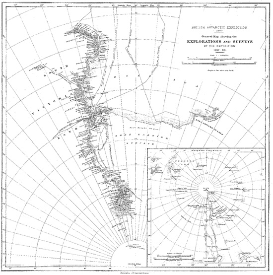
Routes of the parties led by Robert Scott and Roald Amundsen to the South Pole (1911–12), from Apsley Cherry-Garrard’s Worst Journey in the World (New York, 1922).
Although Evans gave a positive report on the Polar Party’s prospects upon his return in late February, the worsening sledging surface that his team encountered should have raised concern. Further, rather than recognize deficits in the food-depot system, leaders at the main base dismissed Evans’s illness as an isolated event. Finally, because Amundsen had taken a different route, no one in the British expedition realized that by the time Evans’s party turned back in early January, the Norwegians had already reached the pole and returned nearly halfway to their base in near perfect sledging conditions. When Terra Nova reached New Zealand on April 2 with the still-prostrate Evans and his report on Scott’s progress, it had been nearly a month since Amundsen’s Fram had docked in Tasmania. Combining the two reports, the world knew that the Norwegians had won the race.
Scott realized Amundsen’s triumph as he approached the pole. He now traveled with only four others: Wilson, Bowers, Edgar Evans, and Lawrence “Titus” Oates, an elite cavalry officer and Boer War veteran charged with tending ponies who had also proven himself in sledging. Scott, Wilson, and Bowers were holding up well, though the falling temperature made for hard sledging on icy, granular snow of the type that Wright associated with deep cold. “The surface was bad,” Wilson complained, “heavy sandy drifts.”58 Oates’s feet were beginning to freeze; Evans had cut his hand badly working on the sledge; Bowers stumped through the snow on foot. Originally part of a support party that had depoted its skis along the way, Bowers walked while the others skied—a difference that could tire even the hardiest sledger.
On January 16, fewer than twenty miles from the pole, they sighted debris left by the Norwegians. “This told the whole story,” Scott wrote. “It is a terrible disappointment, and I am very sorry for my loyal companions.” Those companions, however, took comfort in what they had done. “It is sad that we have been forestalled by the Norwegians,” Bowers wrote, “but I am glad that we have done it by good British man-hauling. This is the greatest journey done by man unaided.” For Wilson, solace came partly in science. While the Norwegians won the “race,” he noted, “We have done what we came for all the same and as our programme was made out.”59
“The POLE. Yes, but under very different circumstances from those expected,” Scott wrote on January 17. “Great God this is an awful place.” His party found the small tent left by Amundsen with a note to Scott and letter for him to take back for the Norwegian king as proof that both groups had reached the goal. Bowers took several rounds of sights to confirm the location, as the Norwegians had done. None of them wanted questions raised about whether they had attained the South Pole such as clouded Robert Peary’s claim to the North Pole. The British departed a day later. “We have turned our back now on the goal of our ambition and must face our 800 miles of solid dragging,” Scott exclaimed on January 18, “and good-bye to most of the daydreams!”60
The surface posed the most relentless problems. It presented the slow, heavy dragging at low, late-summer and early-spring temperatures that Wright would have predicted from his studies of Antarctic snow and ice. “The sun comes out on sandy drifts all on the move in the wind and temp. −20° and gives us an absolutely awful surface with no glide at all for ski or sledge,” Wilson wrote on the first day of the return trip. “This in reality is caused by a constant fall of minute snow crystals—very minute—sometimes instead of crystal plates the fall is of minute agglomerate spicules like tiny sea urchins.”61 Day after day it was much the same, with the sledgers’ diaries filled with complaints about the surface: all pull, no glide, with the sledge runners sometimes sinking so deep into the sandy or crystalline surface that the crossbars plowed through the snow.
They hoped for relief after they left the Polar Plateau on February 7, but the inevitable pitfalls of Beardmore Glacier were followed by even lower temperatures on the Ice Barrier and a persistence of granular snow. “It has been like pulling over desert sand,” Scott wrote. “One’s heart sinks as the sledge stops dead at some sastrugi behind which the surface sand lies thickly heaped.” The temperature now repeatedly plunged below −40°F, which was much lower than Scott expected. Simpson, the expedition’s meteorologist, later used available weather data from the region to calculate just how bad it was for the Polar Party. “There was an unusual absence of wind on the south of the Barrier after the middle of February,” he concluded. “This allowed radiation to take place unchecked, with the consequence that the temperature became unusually low. This fall of temperature caused a precipitation of water-vapour in the form of ice crystals which appeared in the air and all over the surface, making sledging extremely difficult.” Using modern weather data, Antarctic meteorologist Susan Solomon has computed that, during late February and March, the Polar Party faced daily minimum temperatures between 10°F and 20°F below the seasonal norm, which greatly reduced the glide of skis and sledge-runners. “No one in the world would have expected the temperatures and surfaces which we encountered at this time of year,” Scott wrote from the Ice Barrier.62
Hunger stalked the Polar Party too, even though it traveled on full rations. “Could eat twice what we have, especially at lunch and breakfast,” Wilson wrote in a common lament. Until near the journey’s end, they reached most depots with food to spare, but the prescribed amount for each meal did not supply enough calories for pulling at altitude over poor surfaces at low temperatures. Midway back, Scott complained, “Thank the Lord we have good food at each meal, but we get hungrier in spite of it.” By the time the party reached the Ice Barrier, food had become the major topic of conversation. Then the fuel oil began running low owing to leakage from the stores left in the barrier depots, which meant cold pemmican rather than warm hoosh. “The result is telling on all, but mainly on Oates, whose feet are in a wretched condition,” Scott wrote on March 5. No fuel, of course, meant no water.63
The unrelenting heavy sledging, low temperatures, and inadequate diet inevitably weakened everyone. For Evans, the serious troubles began when he gashed his hand on December 31. The wound became infected, and his fingers suffered severe and prolonged frostbite. “Evans has dislodged two finger-nails to-night,” Scott wrote in late January. “His hands are really bad and to my surprise he shows signs of losing heart over it which makes me much disappointed in him.” By the time that the Polar Party reached Beardmore Glacier in early February, Wilson, the party’s physician, noted, “Evans’ fingers suppurating, nose very bad and rotten looking.” By then, Oates’s feet had also reached a critical stage. “Titus’ toes are blackening,” Wilson reported, “and his nose and cheeks are dead yellow.”64 Further, while still on the plateau, Wilson strained a leg tendon so severely that he had to march out of harness for several days, and Scott badly bruised his shoulder in a fall. Although never diagnosed, everyone showed signs of scurvy. Nevertheless, they took time out for geology as they descended the glacier.
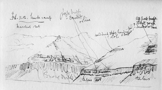
Deep snow and ice covered most of the route from the pole to Ross Island, with the mountains above Beardmore providing the only relief from the featureless monotony. Upon reaching the glacier, the nearly exhausted sledgers steered toward the moraine beneath Mount Buckley. “The moraine was obviously so interesting that . . . I decided to camp and spend the rest of the day geologising,” Scott wrote after lunch on February 8. “We found ourselves under perpendicular cliffs of Beacon sandstone, weathering rapidly and carrying veritable coal seams. From the last Wilson, with his sharp eyes, has picked several plant impressions.” They took away thirty-five pounds of fossils and rock samples. Those specimens could help salvage meaning from a failed attempt to reach the pole first. “I was very late turning in, examining the moraine after supper,” Wilson noted. He sketched the surrounding strata. This break gave the party its last respite.65
One of Edward Wilson’s last sketches, made when he suffered from snow blindness and the Polar Party was running low on supplies, showing the geological strata of exposed rock formations on the north side of Beardmore Glacier, from Scott’s Last Expedition (New York, 1913).
Evans was the first to go. After floundering down the glacier for a week and falling in several crevasses, he became increasingly disoriented. “He’s lost his guts and behaves like an old woman or worse,” Oates complained on February 12 in a characteristically gendered remark. Wilson thought that Evans had injured his brain in a fall and by February 16 described him as “sick and giddy and unable to walk even by the sledge on ski.”66 He dropped far behind the others a day later, and when they went back for him, he was on his knees with his gloves off and a wild look in his eyes. By the time they carried him to the tent, he had slipped into a coma and soon died. Leaving the body, they preceded down the glacier and onto the Ice Barrier.
Oates died next. His feet kept getting worse. The cold and the lack of fuel for hot meals contributed to the problem. By the barrier’s midpoint, he could no longer pull in harness and soon began holding the party back, which irked the soldier in him. “He asked Wilson if he had a chance this morning,” Scott noted on March 10. “In point of fact he has none.” A day later, Scott ordered Wilson to supply everyone with a fatal dose of opium, but Oates struggled on with the others for five more days. “He slept through the night before last, hoping not to wake; but he woke in the morning,” Scott wrote on March 17. “It was blowing a blizzard. He said, ‘I am just going outside and may be some time.’ He went out into the blizzard and we have not seen him since.” Scott called it “the act of a brave man and an English gentleman.”67 March 17 was Oates’s thirty-second birthday. Back at Cape Evans, Tryggve Gran noted this fact in his diary, but Scott did not. Perhaps it was too sad. Perhaps Oates never told him or Scott was beyond caring.
The others marched their last on March 19. Two days earlier, they had left behind everything except the barest essentials and, at Wilson’s request, diaries, field notes, and geological specimens. These they carried until the end. Their final camp stood only eleven miles shy of the massive One Ton Depot, stocked with special treats, where a relief party had waited until March 10. Scott’s right foot had given out and their fuel was nearly gone, but they retained some hope of getting through. They knew their approximate location. Then a blizzard struck. It lasted at least eight days—or so Scott’s diary reported. By then they had eaten all of the remaining food. Some historians have suggested that the blizzard must have ended earlier, but either Wilson and Bowers would not leave Scott or Scott held them back. In any event, they died together, with Wilson and Bowers in an attitude of sleep and Scott between them, his sleeping bag half open and an arm flung across Wilson.
In their last days, the dying men wrote letters to family, friends, and, in Scott’s case, the public. Christians of a highly individualistic and intensely personal stripe, Bowers and Wilson wrote of their faith in God and hope for an afterlife. The agnostic, Scott found his faith in the British state wavering so much that his last written words were laced with beseeching pleas for the government and his friends to care for the family he had left behind. Yet his hopes for science, empire, and his own legacy never faded. To the public, he wrote, “I do not regret this journey, which has shown that Englishmen can endure hardships, help one another, and meet death with as great a fortitude as ever in the past.” In his letter to his wife, he wrote of their two-year-old son, Peter Markham Scott, “Make the boy interested in natural history if you can; it is better than games.” The boy became a renowned ornithologist and environmentalist.68
With Scott lost in the south, Teddy Evans invalided to New Zealand, and Campbell clinging to life in the east, leadership of the expedition passed to Edward Atkinson. After Terra Nova sailed north without news from the Polar Party, Atkinson kept the expedition going as best as possible. Taylor and Simpson sailed with the ship, leaving Debenham and Wright to continue a scaled-back research program in geology, meteorology, and ice physics. At the first opportunity in spring, Atkinson and Wright led a group south onto the Ice Barrier to search for the remains of the Polar Party. With eyes trained to see anything unusual in the ice, Wright spotted it first. “I saw a small object projecting above the surface on the starboard bow,” he later recalled. “It was the 6 inches or so tip of a tent.”69
Atkinson then took command. “We recovered all their gear,” he wrote, “and dug out the sledge with their belongings on it. Amongst these were 35 lbs. of very important geological specimens which had been collected on the moraines of the Beardmore Glacier; at Doctor Wilson’s request they had stuck to these up to the very end, even when disaster stared them in the face and they knew that the specimens were so much weight added to what they had to pull. When everything had been gathered up, we covered them with the outer tent and read the burial service. From this time until well into the next day we started to build a mighty cairn above them.” The party sledged another twenty miles south in search of Oates’s body but found only his sleeping bag.70
Apart from the bodies and diaries, the retrieved rocks generated the most comment, then and ever since. Some critics savaged Scott for taking time to collect and expending effort to haul them. Wilson was most eager to do so, however, and his diary expressed his thrill with the fossilized leaf impressions the rocks contained. “Most of the bigger leaves were like beech leaves in shape and venation,” he noted, knowing that this tied them to a global flora. Debenham, when he saw them, added, “The 35 lbs. of specimens brought back by the Polar Party from Mt. Buckley contain impressions of fossil plants of late Paleozoic age, some of which a cursory inspection identifies as occurring in other parts of the world.” On closer study, the fossils were found to include imprints of the long-sought Glossopteris plant, whose presence in Antarctica supported the hypothesis that the southern continents once formed an immense supercontinent. “Meager as it is, the material collected by the Polar Party calls up a picture of an Antarctic land on which it is reasonable to believe were evolved the elements of a new flora that spread in diverging lines over a Paleozoic continent,” Cambridge botanist A. C. Seward wrote in 1914. “The discovery of Glossopteris on the Buckley Island moraine supplies what is needed to bring hypothesis within the range of established fact.”71
After Terra Nova returned to collect the survivors in January 1912, the expedition erected a memorial cross above Hut Point. “It is on the top of Observation Hill,” Debenham wrote. “To the west one sees the Western Mountains and Mts Lister and Discovery, while to the south lies White Island and then the blank waste of the Barrier, a dead white plain hardly differing from the sky in colour.” Its upright post bore the same line from Tennyson’s Ulysses that Nansen had applied to Amundsen: “to strive, to seek, to find, and not to yield.”72
Years later, in a poem about the Antarctic, Debenham wrote, “Men are not old here / Only the rocks are old, and the sheathing ice.” The poem went on to comment on the progress of science in that so-called Quiet Land, “The corner is turned: we can see over the brow. / We have sought and found, and it is the land that has yielded.”73 Perhaps so, yet the land took its toll, and the ice continued its relentless push toward the sea. In the 1960s, the ice encasing Framheim, Amundsen’s winter quarters, detached from the Ice Barrier, drifted north, and dropped any vestiges of the Norwegians’ camp onto the ocean floor. If the movement ascribed to the Ice Barrier by the Nimrod and Terra Nova expeditions stays constant, the Polar Party’s remains, buried beneath a century of accumulated snows, will likewise soon reach the ice front, float free in a tabular burg, and gradually dissolve into the deep southern seas. Given the regional warming that geologists on these expeditions detected, it may have already happened.
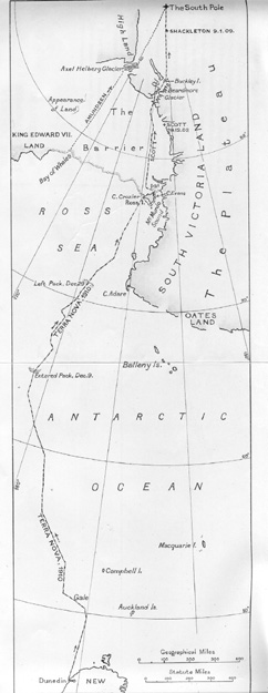
Antarctic map showing what was known in 1910, following the Discovery and Nimrod expeditions, including the sailing and sledging routes of these expeditions, from Ernest Shackleton’s Heart of the Antarctic (Philadelphia, 1909).