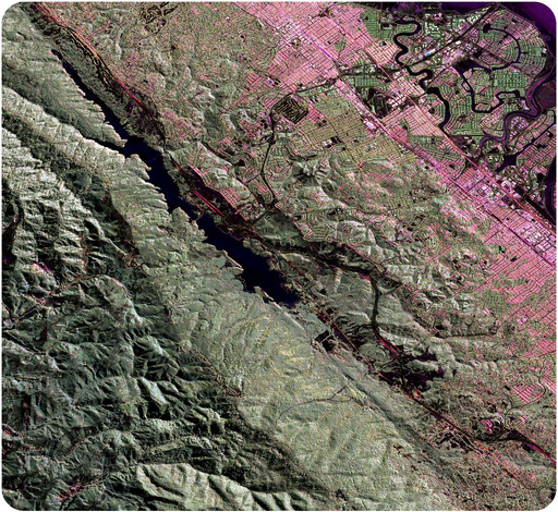

A portion of the 800-mile-long San Andreas Fault as it runs through the San Francisco Bay Area is seen from the upper left to the lower right of this image. The development in pink and green is San Mateo and Burlingame. Foster City, which is built on fill, has curved streets extending into the bay. The fault forms a trough that is filled with water at Crystal Springs Reservoir. Scientists will use space-based radar along this same flight path over the next years to look for changes in the ground surface along the fault.
Enormous slabs of lithosphere move unevenly over the planet’s spherical surface, resulting in earthquakes. This chapter deals with two types of geological activity that occur because of plate tectonics: mountain building and earthquakes. First, we will consider what can happen to rocks when they are exposed to stress.
Stress is the force applied to an object. In geology, stress is the force per unit area that is placed on a rock. Four types of stresses act on materials.
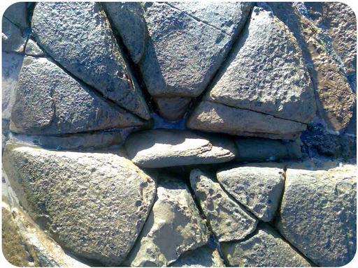
Figure 7.1
Stress caused these rocks to fracture.
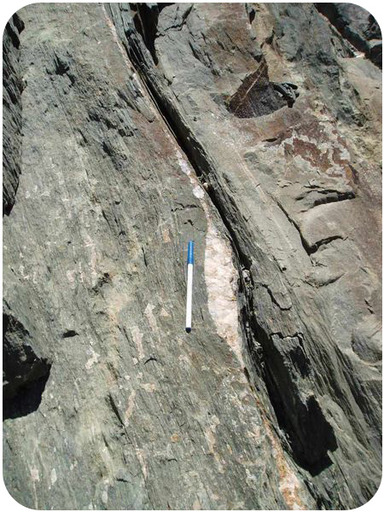
Figure 7.2
Shearing in rocks. The white quartz vein has been elongated by shear.
When stress causes a material to change shape, it has undergone strain or deformation. Deformed rocks are common in geologically active areas.
A rock’s response to stress depends on the rock type, the surrounding temperature, and pressure conditions the rock is under, the length of time the rock is under stress, and the type of stress.
Rocks have three possible responses to increasing stress (illustrated in Figure below ):
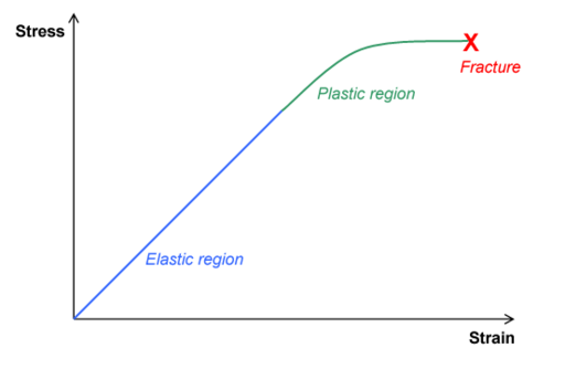
Figure 7.3
With increasing stress, the rock undergoes: (1) elastic deformation, (2) plastic deformation, and (3) fracture.
Under what conditions do you think a rock is more likely to fracture? Is it more likely to break deep within Earth’s crust or at the surface? What if the stress applied is sharp rather than gradual?
Sedimentary rocks are important for deciphering the geologic history of a region because they follow certain rules.
You can trace the deformation a rock has experienced by seeing how it differs from its original horizontal, oldest-on-bottom position ( Figure below ). This deformation produces geologic structures such as folds, joints, and faults that are caused by stresses ( Figure below ). Using the rules listed above, try to figure out the geologic history of the geologic column below.
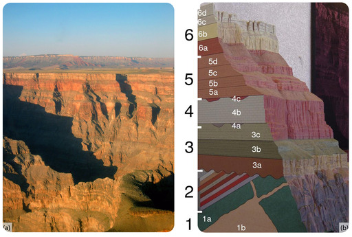
Figure 7.4
(a) In the Grand Canyon, the rock layers are exposed like a layer cake. Each layer is made of sediments that were deposited in a particular environment - perhaps a lake bed, shallow offshore region, or a sand dune. (b) In this geologic column of the Grand Canyon, the sedimentary rocks of groups 3 through 6 are still horizontal. Group 2 rocks have been tilted. Group 1 rocks are not sedimentary. The oldest layers are on the bottom and youngest are on the top.
Rocks deforming plastically under compressive stresses crumple into folds ( Figure below ). They do not return to their original shape. If the rocks experience more stress, they may undergo more folding or even fracture.
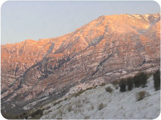
Figure 7.5
Snow accentuates the fold exposed in these rocks in Provo Canyon, Utah.
Three types of folds are seen.
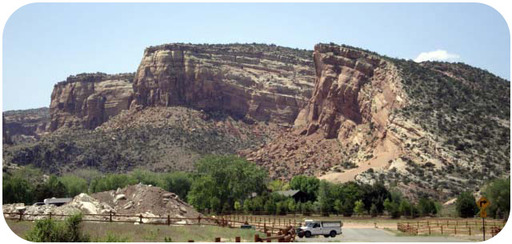
Figure 7.6
At Colorado National Monument, the rocks in a monocline plunge toward the ground.

Figure 7.7
(a) Schematic of an anticline. (b) An anticline exposed in a road cut in New Jersey.
When rocks arch upward to form a circular structure, that structure is called a dome. If the top of the dome is sliced off, where are the oldest rocks located?

Figure 7.8
(a) Schematic of a syncline. (b) This syncline is in Rainbow Basin, California.
When rocks bend downward in a circular structure, that structure is called a basin ( Figure below ). If the rocks are exposed at the surface, where are the oldest rocks located?
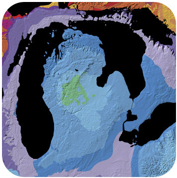
Figure 7.9
Basins can be enormous. This is a geologic map of the Michigan Basin, which is centered in the state of Michigan but extends into four other states and a Canadian province.
A rock under enough stress will fracture. If there is no movement on either side of a fracture, the fracture is called a joint , as shown in ( Figure below ).
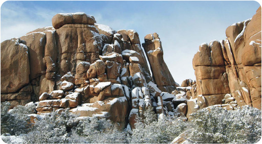
Figure 7.10
Granite rocks in Joshua Tree National Park showing horizontal and vertical jointing. These joints formed when the confining stress was removed from the granite.
If the blocks of rock on one or both sides of a fracture move, the fracture is called a fault ( Figure below ). Sudden motions along faults cause rocks to break and move suddenly. The energy released is an earthquake.
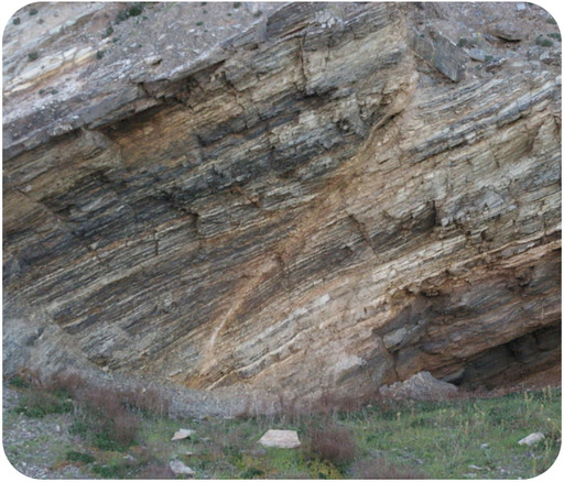
Figure 7.11
Faults are easy to recognize as they cut across bedded rocks.
Slip is the distance rocks move along a fault. Slip can be up or down the fault plane. Slip is relative, because there is usually no way to know whether both sides moved or only one. Faults lie at an angle to the horizontal surface of the Earth. That angle is called the fault’s dip. The dip defines which of two basic types a fault is. If the fault’s dip is inclined relative to the horizontal, the fault is a dip-slip fault ( Figure below ). There are two types of dip-slip faults. In normal faults , the hanging wall drops down relative to the footwall. In reverse faults , the footwall drops down relative to the hanging wall.
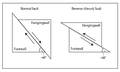
Figure 7.12
This diagram illustrates the two types of dip-slip faults: normal faults and reverse faults. Imagine miners extracting a resource along a fault. The hanging wall is where miners would have hung their lanterns. The footwall is where they would have walked.
An animation of a normal fault is seen here: http://earthquake.usgs.gov/learn/animations/animation.php?flash_title=Normal+Fault&flash_file=normalfault&flash_width=220&flash_height=320 .
A thrust fault is a type of reverse fault in which the fault plane angle is nearly horizontal. Rocks can slip many miles along thrust faults ( Figure below ).
An animation of a thrust fault is seen here: http://earthquake.usgs.gov/learn/animations/animation.php?flash_title=Thrust+Fault&flash_file=thrustfault&flash_width=220&flash_height=320 .
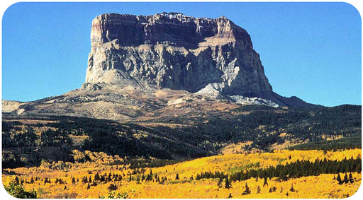
Figure 7.13
At Chief Mountain in Montana, the upper rocks at the Lewis Overthrust are more than 1 billion years older than the lower rocks. How could this happen?
Normal faults can be huge. They are responsible for uplifting mountain ranges in regions experiencing tensional stress ( Figure below ).
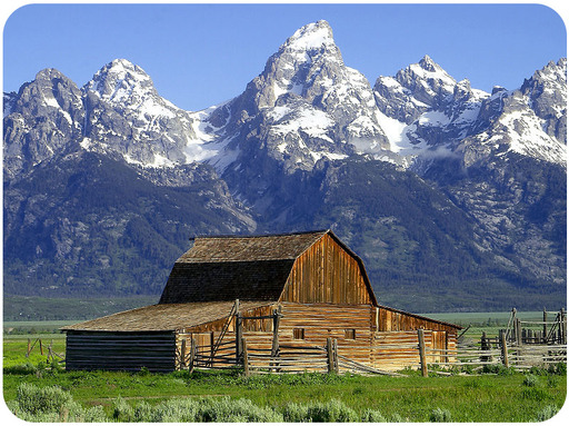
Figure 7.14
The Teton Range in Wyoming rose up along a normal fault.
A strike-slip fault is a dip-slip fault in which the dip of the fault plane is vertical. Strike-slip faults result from shear stresses. ( Figure below ).
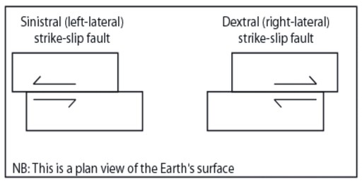
Figure 7.15
Imagine placing one foot on either side of a strike-slip fault. One block moves toward you. If that block moves toward your right foot, the fault is a right-lateral strike-slip fault; if that block moves toward your left foot, the fault is a left-lateral strike-slip fault.
California’s San Andreas Fault is the world’s most famous strike-slip fault. It is a right-lateral strike slip fault ( Figure below ).
A strike-slip fault animation: http://earthquake.usgs.gov/learn/animations/animation.php?flash_title=Strike-Slip+Fault&flash_file=strikeslip&flash_width=240&flash_height=310 .
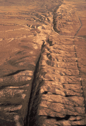
Figure 7.16
The San Andreas is a massive transform fault.
People sometimes say that California will fall into the ocean someday, which is not true. This animation shows movement on the San Andreas into the future: http://visearth.ucsd.edu/VisE_Int/aralsea/bigone.html .
Two converging continental plates smash upwards to create mountain ranges ( Figure below ). Stresses from this uplift cause folds, reverse faults, and thrust faults, which allow the crust to rise upwards.
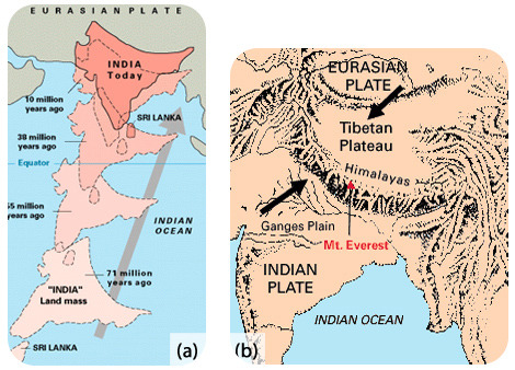
Figure 7.17
(a) The world
Subduction of oceanic lithosphere at convergent plate boundaries also builds mountain ranges ( Figure below ).
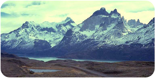
Figure 7.18
The Andes Mountains are a chain of continental arc volcanoes that build up as the Nazca Plate subducts beneath the South American Plate.
When tensional stresses pull crust apart, it breaks into blocks that slide up and drop down along normal faults. The result is alternating mountains and valleys, known as a basin-and-range ( Figure below ).

Figure 7.19
(a) In basin-and-range, some blocks are uplifted to form ranges, known as horsts, and some are down-dropped to form basins, known as grabens. (b) Mountains in Nevada are of classic basin-and-range form. The photographer is in the Nopah Range and is looking across a basin to the Kingston Range beyond.
This is a very quick animation of movement of blocks in a basin-and-range setting: http://earthquake.usgs.gov/learn/animations/animation.php?flash_title=Horst+%26amp%3B+Graben&flash_file=horstandgraben&flash_width=380&flash_height=210 .
An earthquake is sudden ground movement caused by the sudden release of energy stored in rocks. Earthquakes happen when so much stress builds up in the rocks that the rocks rupture. The energy is transmitted by seismic waves. Each year there are more than 150,000 earthquakes strong enough to be felt by people and 900,000 recorded by seismometers!
The description of how earthquakes occur is called elastic rebound theory ( Figure below ).
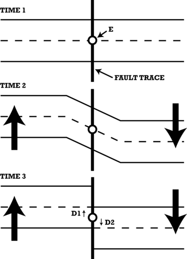
Figure 7.20
Elastic rebound theory. Stresses build on both sides of a fault, causing the rocks to deform plastically (Time 2). When the stresses become too great, the rocks break and end up in a different location (Time 3). This releases the built up energy and creates an earthquake.
Elastic rebound theory in an animation: http://earthquake.usgs.gov/learn/animations/animation.php?flash_title=Elastic+Rebound&flash_file=elasticrebound&flash_width=300&flash_height=350 .
In an earthquake, the initial point where the rocks rupture in the crust is called the focus . The epicenter is the point on the land surface that is directly above the focus. In about 75% of earthquakes, the focus is in the top 10 to 15 kilometers (6 to 9 miles) of the crust. Shallow earthquakes cause the most damage because the focus is near where people live. However, it is the epicenter of an earthquake that is reported by scientists and the media ( Figure above ).
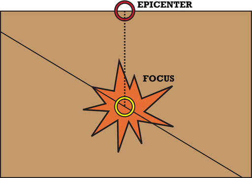
Figure 7.21
In the vertical cross section of crust, there are two features labeled - the focus and the epicenter, which is directly above the focus.
This animation shows the relationship between focus and epicenter of an earthquake: http://highered.mcgraw-hill.com/olcweb/cgi/pluginpop.cgi?it=swf::640::480::/sites/dl/free/0072402466/30425/16_04.swf::Fig.%20%2016.4%20-%20Focus%20of%20an%20Earthquake .
Nearly 95% of all earthquakes take place along one of the three types of plate boundaries, but earthquakes do occur along all three types of plate boundaries.
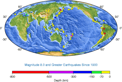
Figure 7.22
Earthquake epicenters for magnitude 8.0 and greater events since 1900. The earthquake depth shows that most large quakes are shallow focus, but some subducted plates cause deep focus quakes.
Deadly earthquakes occur at transform plate boundaries. Transform faults have shallow focus earthquakes. Why do you think this is so? The faults along the San Andreas Fault zone produce around 10,000 earthquakes a year. Most are tiny, but occasionally one is massive. In the San Francisco Bay Area, the Hayward Fault was the site of a magnitude 7.0 earthquake in 1868. The 1906 quake on the San Andreas Fault had a magnitude estimated at about 7.9 ( Figure below ).
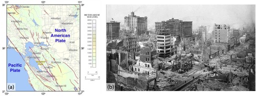
Figure 7.23
(a) The San Andreas Fault zone in the San Francisco Bay Area. (b) The 1906 San Francisco earthquake is still the most costly natural disaster in California history. About 3,000 people died and 28,000 buildings were lost, mostly in the fire.
Recent California earthquakes"
Although California is prone to many natural hazards, including volcanic eruptions at Mt. Shasta or Mt. Lassen, and landslides on coastal cliffs, the natural hazard the state is linked with is earthquakes. In this video, the boundaries between three different tectonic plates and the earthquakes that result from their interactions are explored
(9b)
:
http://www.youtube.com/watch?v=upEh-1DpLMg
(1:59).
New Zealand also has strike-slip earthquakes, about 20,000 a year! Only a small percentage of those are large enough to be felt. A 6.3 quake in Christchurch in February 2011 killed about 180 people.
Earthquakes at convergent plate boundaries mark the motions of subducting lithosphere as it plunges through the mantle ( Figure below ).
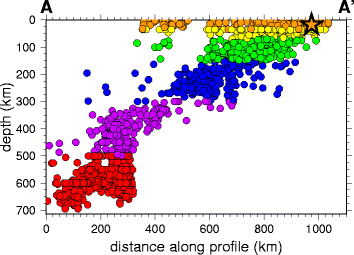
Figure 7.24
This cross section of earthquake epicenters with depth outlines the subducting plate with shallow, intermediate, and deep earthquakes.
Convergent plate boundaries produce earthquakes all around the Pacific Ocean basin. The Philippine Plate and the Pacific Plate subduct beneath Japan, creating a chain of volcanoes and as many as 1,500 earthquakes annually.
In March 2011 an enormous 9.0 earthquake struck off of Sendai in northeastern Japan. This quake, called the 2011 Tōhoku earthquake, was the most powerful ever to strike Japan and one of the top five known in the world. Damage from the earthquake was nearly overshadowed by the tsunami it generated, which wiped out coastal cities and towns ( Figure below ). Two months after the earthquake, about 25,000 people were dead or missing, and 125,000 buildings had been damaged or destroyed. Aftershocks, some as large as major earthquakes, have continued to rock the region.
A map of aftershocks is seen here: http://earthquake.usgs.gov/earthquakes/seqs/events/usc0001xgp/ .
Here is an interactive feature article about the earthquake: http://www.nytimes.com/interactive/2011/03/11/world/asia/maps-of-earthquake-and-tsunami-damage-in-japan.html .
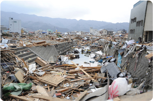
Figure 7.25
Destruction in Ofunato, Japan, from the 2011 T
The Pacific Northwest of the United States is at risk from a potentially massive earthquake that could strike any time. Subduction of the Juan de Fuca plate beneath North America produces active volcanoes, but large earthquakes only hit every 300 to 600 years. The last was in 1700, with an estimated magnitude of around 9.
An image of earthquakes beneath the Pacific Northwest and the depth to the epicenter is shown here: http://pubs.usgs.gov/ds/91/ .
Elastic rebound at a subduction zone generates an earthquake in this animation: http://www.iris.edu/hq/files/programs/education_and_outreach/aotm/5/AOTF5_Subduction_ElasticRebound480.mov .
Massive earthquakes are the hallmark of the thrust faulting and folding when two continental plates converge ( Figure below ). The 2001 Gujarat earthquake in India was responsible for about 20,000 deaths, and many more people became injured or homeless.
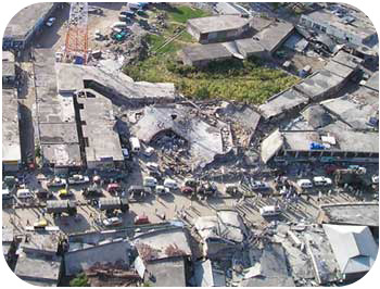
Figure 7.26
Damage from the 2005 Kashmir earthquake.
In Understanding Earthquakes: From Research to Resilience, scientists try to understand the mechanisms that cause earthquakes and tsunamis and the ways that society can deal with them
(3d)
:
http://www.youtube.com/watch?v=W5Qz-aZ2nUM
(8:06).
Earthquakes at mid-ocean ridges are small and shallow because the plates are young, thin, and hot. On land where continents split apart, earthquakes are larger and stronger.
Intraplate earthquakes are the result of stresses caused by plate motions acting in solid slabs of lithosphere. In 1812, a magnitude 7.5 earthquake struck near New Madrid, Missouri. The earthquake was strongly felt over approximately 50,000 square miles and altered the course of the Mississippi River. Because very few people lived there at the time, only 20 people died. Many more people live there today ( Figure below ). A similar earthquake today would undoubtedly kill many people and cause a great deal of property damage.
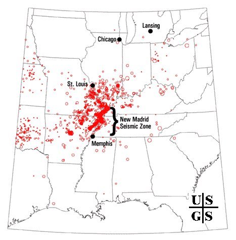
Figure 7.27
The New Madrid Seismic Zone is within the North American plate. Around 4,000 earthquakes have occurred in the region since 1974.
Energy is transmitted in waves. Every wave has a high point called a crest and a low point called a trough . The height of a wave from the center line to its crest is its amplitude . The distance between waves from crest to crest (or trough to trough) is its wavelength . The parts of a wave are illustrated in Figure below .
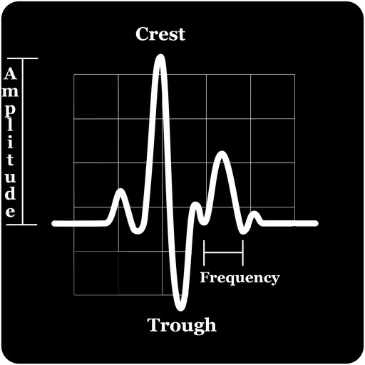
Figure 7.28
The crest, trough, and amplitude are illustrated in this diagram.
The energy from earthquakes travels in seismic waves, which were discussed in the chapter “Plate Tectonics.” The study of seismic waves is known as seismology. Seismologists use seismic waves to learn about earthquakes and also to learn about the Earth’s interior. The two types of seismic waves described in “Plate Tectonics,” P-waves and S-waves, are known as body waves because they move through the solid body of the Earth. P-waves travel through solids, liquids, and gases. S-waves only move through solids. Surface waves travel along the ground, outward from an earthquake’s epicenter. Surface waves are the slowest of all seismic waves, traveling at 2.5 km (1.5 miles) per second. There are two types of surface waves ( Figure below ).
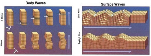
Figure 7.29
P-waves move material forward and backward in the direction they are traveling. The material returns to its original size and shape after the P-wave goes by. S-waves move up and down, perpendicular to the direction the wave is traveling. This motion produces shear stresses.
In an earthquake, body waves produce sharp jolts. The rolling motions of surface waves do most of the damage in an earthquake.
Interesting earthquake videos are seen at National Geographic Videos, Environment Video, Natural Disasters, Earthquakes: http://video.nationalgeographic.com/video/player/environment/ . Titles include:
Tsunami are deadly ocean waves from an earthquake. The sharp jolt of an undersea quake forms a set of waves that travel through the sea entirely unnoticed. When they come onto shore, they can grow to enormous heights. Fortunately, few undersea earthquakes generate tsunami.
How a tsunami forms is shown in this animation: http://highered.mcgraw-hill.com/olcweb/cgi/pluginpop.cgi?it=swf::640::480::/sites/dl/free/0072402466/30425/16_19.swf::Fig.%2016.19%20-%20Formation%20of%20a%20Tsunami .
The Boxing Day Tsunami of December 26, 2004 was by far the deadliest of all time ( Figure below ). The tsunami was caused by the 2004 Indian Ocean Earthquake. With a magnitude of 9.2, it was the second largest earthquake ever recorded. The extreme movement of the crust displaced trillions of tons of water along the entire length of the rupture. Several tsunami waves were created with about 30 minutes between the peaks of each one. The waves that struck nearby Sumatra 15 minutes after the quake reached more than 10 meters (33 feet) in height. The size of the waves decreased with distance from the earthquake and were about 4 meters (13 feet) high in Somalia.
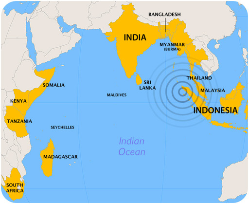
Figure 7.30
The countries that were most affected by the 2004 Boxing Day tsunami.
About 230,000 people died in eight countries ( Figure below ) with fatalities even as far away as South Africa, nearly 8,000 kilometers (5,000 miles) from the earthquake epicenter. More than 1.2 million people lost their homes and many more lost their ways of making a living.
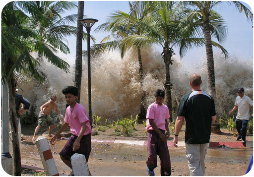
Figure 7.31
The Boxing Day tsunami strikes a beach in Thailand.
The 2011 Tōhoku earthquake in Japan created massive tsunami waves that hit the island nation. As seen in Figure below , waves in some regions topped 9 meters (27 feet). The tsunami did much more damage than the massive earthquake ( Figure below ). Worst was the damage done to nuclear power plants along the northeastern coast.

Figure 7.32
This map shows the peak tsunami wave heights.
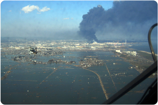
Figure 7.33
An aerial view shows the damage to Sendai, Japan caused by the earthquake and tsunami. The black smoke is coming from an oil refinery, which was set on fire by the earthquake. The tsunami prevented efforts to extinguish the fire until several days after the earthquake.
As a result of the 2004 tsunami, an Indian Ocean warning system was put into operation in June 2006. Prior to 2004, no one had thought a large tsunami was possible in the Indian Ocean. In comparison, a warning system has been in effect around the Pacific Ocean for more than 50 years ( Figure below ). Why do you think a Pacific warning system has been in place for so long? The system was used to warn of possible tsunami waves after the Tōhoku earthquake. People were evacuated along many pacific coastlines although the waves were not nearly as large as those that struck Japan shortly after the quake.
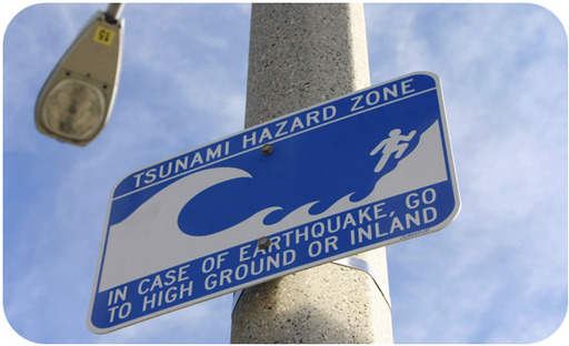
Figure 7.34
This sign indicates a tsunami hazard zone in California.
Seismograms record seismic waves. Over the past century, scientists have developed several ways of measuring earthquake intensity. The currently accepted method is the moment magnitude scale, which measures the total amount of energy released by the earthquake. At this time, seismologists have not found a reliable method for predicting earthquakes.
A seismograph produces a graph-like representation of the seismic waves it receives and records them onto a seismogram ( Figure below ). Seismograms contain information that can be used to determine how strong an earthquake was, how long it lasted, and how far away it was. Modern seismometers record ground motions using electronic motion detectors. The data are then kept digitally on a computer.
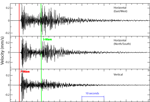
Figure 7.35
These seismograms show the arrival of P-waves and S-waves. The surface waves arrive just after the S-waves and are difficult to distinguish. Time is indicated on the horizontal portion (or x-axis) of the graph.
If a seismogram records P-waves and surface waves but not S-waves, the seismograph was on the other side of the Earth from the earthquake. The amplitude of the waves can be used to determine the magnitude of the earthquake, which will be discussed in a later section.
To locate an earthquake epicenter:
1. Scientists first determine the epicenter distance from three different seismographs. The longer the time between the arrival of the P-wave and S-wave, the farther away is the epicenter. So the difference in the P and S wave arrival times determines the distance between the epicenter and a seismometer. This animation shows how distance is determined using P, S, and surface waves: http://www.iris.edu/hq/files/programs/education_and_outreach/aotm/12/IRIStravelTime_Bounce_480.mov .
2. The scientist then draws a circle with a radius equal to the distance from the epicenter for that seismograph. The epicenter is somewhere along that circle. This is done for three locations. Using data from two seismographs, the two circles will intercept at two points. A third circle will intercept the other two circles at a single point. This point is the earthquake epicenter ( Figure below ). Although useful for decades, this technique has been replaced by digital calculations.
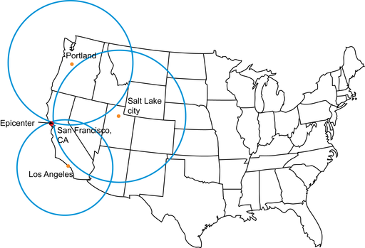
Figure 7.36
Circles are drawn with radii representing the distance from each seismic station to the earthquake's epicenter. The intersection of these three circles is the earthquake's epicenter.
Seismic stations record ten earthquakes in this animation: http://www.iris.edu/hq/files/programs/education_and_outreach/aotm/12/TravelTime_Sphere_10Stn_480.mov .
People have always tried to quantify the size of and damage done by earthquakes. Since early in the 20 th century, there have been three methods. What are the strengths and weaknesses of each?
The Richter scale and the moment magnitude scale are logarithmic.
How does the amplitude of the largest seismic wave of a magnitude 5 earthquake compare with the largest wave of a magnitude 4 earthquake? How does it compare with a magnitude 3 quake? The amplitude of the largest seismic wave of a magnitude 5 quake is 10 times that of a magnitude 4 quake and 100 times that of a magnitude 3 quake.
How does an increase in two integers on the moment magnitude scale compare in terms of the amount of energy released? Two integers equals a 900-fold increase in released energy.
Which scale do you think is best? With the Richter scale, a single sharp jolt measures higher than a very long intense earthquake that releases more energy. The moment magnitude scale more accurately reflects the energy released and the damage caused. Most seismologists now use the moment magnitude scale.
The way scientists measure earthquake intensity and the two most common scales, Richter and moment magnitude, are described along with a discussion of the 1906 San Francisco earthquake in
Measuring Earthquakes
video
(3d)
:
http://www.youtube.com/watch?v=wtlu_aDteCA
(2:54).
In a single year, on average, more than 900,000 earthquakes are recorded and 150,000 of them are strong enough to be felt. Each year about 18 earthquakes are major with a Richter magnitude of 7.0 to 7.9, and on average one earthquake has a magnitude of 8 to 8.9.
Magnitude 9 earthquakes are rare. The United States Geological Survey lists five since 1900 (see Figure below ) and ( Table below ). All but the Great Indian Ocean Earthquake of 2004 occurred somewhere around the Pacific Ocean basin.
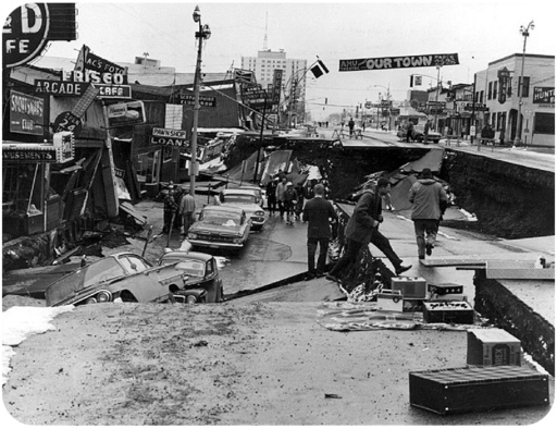
Figure 7.37
The 1964 Good Friday Earthquake centered in Prince William Sound, Alaska released the second most amount of energy of any earthquake in recorded history.
Table 7.1
| Location | Year | Magnitude |
| Valdivia, Chile | 1960 | 9.5 |
| Prince William Sound, Alaska | 1964 | 9.2 |
| Great Indian Ocean Earthquake | 2004 | 9.1 |
| Kamchatka, Alaska | 1952 | 9.0 |
| Tōhoku, Japan | 2011 | 9.0 |
Scientists are a long way from being able to predict earthquakes. A good prediction must be accurate as to where an earthquake will occur, when it will occur, and at what magnitude it will be so that people can evacuate. An unnecessary evacuation is expensive and causes people not to believe authorities the next time an evacuation is ordered.
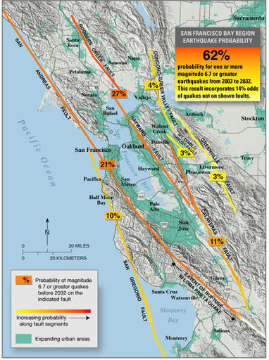
Figure 7.38
The probabilities of earthquakes striking along various faults in the San Francisco area between 2003 (when the work was done) and 2032.
Where an earthquake will occur is the easiest feature to predict. Scientists know that earthquakes take place at plate boundaries and tend to happen where they’ve occurred before ( Figure above ). Earthquake-prone communities should always be prepared for an earthquake. These communities can implement building codes to make structures earthquake safe.
When an earthquake will occur is much more difficult to predict. Since stress on a fault builds up at the same rate over time, earthquakes should occur at regular intervals ( Figure below ). But so far scientists cannot predict when quakes will occur even to within a few years.
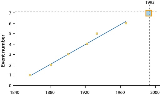
Figure 7.39
Around Parkfield, California, an earthquake of magnitude 6.0 or higher occurs about every 22 years. So seismologists predicted that one would strike in 1993, but that quake came in 2004 - 11 years late.
Signs sometimes come before a large earthquake. Small quakes, called foreshocks, sometimes occur a few seconds to a few weeks before a major quake. However, many earthquakes do not have foreshocks and small earthquakes are not necessarily followed by a large earthquake. Often, the rocks around a fault will dilate as microfractures form. Ground tilting, caused by the buildup of stress in the rocks, may precede a large earthquake, but not always. Water levels in wells fluctuate as water moves into or out of fractures before an earthquake. This is also an uncertain predictor of large earthquakes. The relative arrival times of P-waves and S-waves also decreases just before an earthquake occurs.
Folklore tells of animals behaving erratically just before an earthquake. Mostly these anecdotes are told after the earthquake. If indeed animals sense danger from earthquakes or tsunami, scientists do not know what it is they could be sensing, but they would like to find out.
The geology of California underlies the state’s wealth of natural resources as well as its natural hazards. This video explores the enormous diversity of California’s geology
(9a)
:
http://www.youtube.com/watch?v=QzdBx9zL0ZY
(57:50).
Earthquakes are natural disasters that cause enormous amounts of damage, second only to hurricanes. Earthquake-safe construction techniques, securing heavy objects, and preparing an emergency kit are among the precautions people can take to minimize damage.
Earthquakes kill people and cause property damage. However, the ground shaking almost never kills people, and the ground does not swallow someone up. The damage depends somewhat on the earthquake size but mostly on the quality of structures. Structures falling on people injure and kill them. More damage is done and more people are killed by the fires that follow an earthquake than the earthquake itself.
What makes an earthquake deadly?

Figure 7.40
A landslide in a neighborhood in Anchorage, Alaska, after the 1964 Great Alaska earthquake.
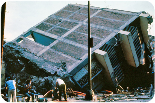
Figure 7.41
Liquefaction of sediments in Mexico City caused the collapse of many buildings in the 1985 earthquake.
Earthquake effects on buildings are seen in this animation: http://www.iris.edu/hq/files/programs/education_and_outreach/aotm/6/SeismicBuilding-Narrated480.mov .
In earthquake-prone areas, city planners try to reduce hazards. For example, in the San Francisco Bay Area, maps show how much shaking is expected for different ground types ( Figure below ). This allows planners to locate new hospitals and schools more safely.
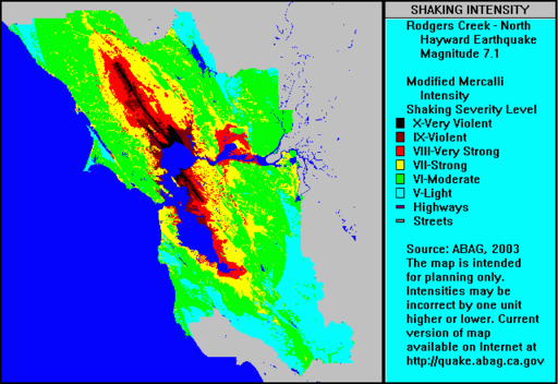
Figure 7.42
The expected Modified Mercalli Intensity Scale for an earthquake of magnitude 7.1 on the northern portion of the Hayward Fault.
Construction is a large factor in what happens during an earthquake. For example, many more people died in the 1988 Armenia earthquake where people live in mud houses than in the 1989 earthquake in Loma Prieta. Most buildings in California’s earthquake country are designed to be earthquake safe.
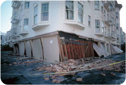
Figure 7.43
The first floor of this San Francisco building is collapsing after the 1989 Loma Prieta earthquake.
To make older buildings more earthquake safe, retrofitting with steel or wood can reinforce a building's structure and its connections ( Figure below ). Elevated freeways and bridges can also be retrofitted so that they do not collapse.
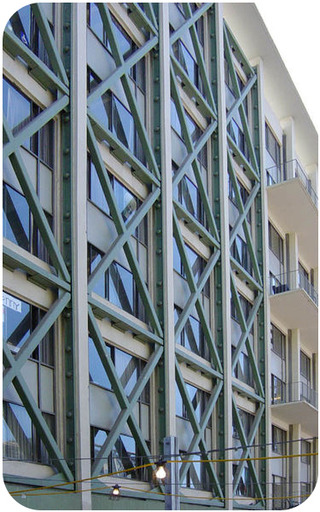
Figure 7.44
Steel trusses were built in an x-pattern to retrofit a dormitory at the University of California, Berkeley. The building is very near the Hayward Fault.
Fires often cause more damage than the earthquake. Fires start because seismic waves rupture gas and electrical lines, and breaks in water mains make it difficult to fight the fires ( Figure below ). Builders zigzag pipes so that they bend and flex when the ground shakes. In San Francisco, water and gas pipelines are separated by valves so that areas can be isolated if one segment breaks.
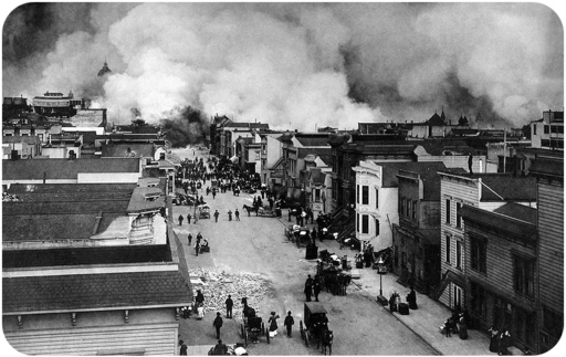
Figure 7.45
In the 1906 San Francisco earthquake, fire was much more destructive than the ground shaking.
Why aren’t all structures in earthquakes zones constructed for maximum safety? Cost, of course. More sturdy structures are much more expensive to build. So communities must weigh how great the hazard is, what different building strategies cost, and make an informed decision.
There are many things you can do to protect yourself before, during, and after an earthquake.
Opening image courtesy of NASA, http://www.nasa.gov/multimedia/imagegallery/image_feature_1395.html , and is under the public domain.