
10.0 mi/5.0 hr
in the Desolation Wilderness near Fallen Leaf Lake
It doesn’t take a long expedition to see the rugged alpine beauty of Desolation Wilderness. This trip, a day hike to Susie and Heather Lakes, is a perfect example. Start at the Glen Alpine trailhead. The trail to Susie and Heather Lakes begins as a rocky road. You will pass a waterfall on Glen Alpine Creek and a vintage resort, now something of a ghost town, on the right. At 1.2 miles, you’ll see a sign for Gilmore, Susie, and Grass Lakes. Here you start to climb, steady and rhythmic (you’ll pass a short cutoff on the left to little Grass Lake, which adds one mile to your trip each way). Continue straight, signed for Susie, Heather, and Aloha Lakes. At four miles, you’ll reach the eastern shore of Susie Lake. The route runs along Susie Lake, and continues to its southern edge, and then it is another mile to Heather Lake. The granite-lined lake is deep and wide, and is set in a landscape of classic high Sierra scenery. There you go. Everything you could ask for in just a day.
User Groups: Hikers, dogs, and horses. No mountain bikes. No wheelchair facilities.
Permits: Permits are required year-round for both day and overnight use. Day hikers may obtain a free permit from a ranger station or may self-issue the Glen Alpine trailhead. Backpackers camping in Desolation Wilderness are subject to trailhead quotas. There is a $5 reservation fee, plus $5 per person for one night, $10 per person for two or more nights up to 14 days (nonrefundable); reserve at www.recreation.gov. Children ages 12 and under are free. Golden Passes do not apply to personal-use permits. For groups, the cost of a single permit will not exceed $100.
Maps: For a map, ask the U.S. Forest Service for Desolation Wilderness. A Lake Tahoe or Desolation Wilderness map is also available for a fee from Tom Harrison Maps. For a topographic map, ask the USGS for Emerald Bay.
Directions: From South Lake Tahoe, take Highway 89 north and drive 2.9 miles to Fallen Leaf Lake Road. Turn left and drive 4.8 miles on a narrow road (go slow, watch for oncoming vehicles) past the Fallen Leaf Marina to a fork. Take the left fork on Road 1216, signed for Lily Lake and the Desolation Wilderness. Drive 0.7 mile to the trailhead, at the road’s end.
Contact: Lake Tahoe Basin Management Unit, South Lake Tahoe, 530/543-2600, www.fs.usda.gov/ltbmu; visitors center (open daily mid-June-Sept., Sat.-Sun. Memorial Day-mid-Oct.), 530/543-2674.
2.0 mi/1.0 hr

near South Lake Tahoe
Fallen Leaf Lake, at 6,400 feet in elevation, is the second-largest lake in the Tahoe Basin. Many call it one of the prettiest. Most of its shorefront lands are privately owned. But this path allows you access to the area that is public. This is a short, mostly flat trail that leads to the lake and then along its northern edge to the dam, which you can walk across. Much of the trail hugs the lake’s shoreline, so you can look out across the blue water and take in deep inside the feeling that comes with deep, sapphire waters. You also get excellent views of Glen Alpine Canyon and Mount Tallac. In the fall, the shoreline of Fallen Leaf Lake is one of the best spots near Tahoe to admire the quaking aspens as they turn from yellow to gold. Campers staying at Fallen Leaf Lake Campground can access this trail from their tents.
User Groups: Hikers, dogs, horses, and mountain bikes. No wheelchair facilities.
Permits: No permits are required. Parking and access are free.
Maps: For a map, ask the U.S. Forest Service for Lake Tahoe Basin Management Unit. A Lake Tahoe map is available for a fee from Tom Harrison Maps. For a topographic map, ask the USGS for Emerald Bay.
Directions: From South Lake Tahoe, take Highway 89 north and drive 2.9 miles to Fallen Leaf Lake Road. Turn left and drive 0.8 mile to the Fallen Leaf Lake dirt parking area on the right. It is not signed.
Contact: Lake Tahoe Basin Management Unit, South Lake Tahoe, 530/543-2600, www.fs.usda.gov/ltbmu; visitors center (open daily mid-June-Sept., Sat.-Sun. Memorial Day-mid-Oct.), 530/543-2674.
1.0 mi/0.5 hr

at Angora Lake near South Lake Tahoe in Tahoe National Forest
Upper Angora Lake is a pristine jewel backed by a high granite wall. From the parking lot, hike uphill on the signed dirt road, and in 15 minutes, you’ll be looking at Lower Angora Lake off to the left, which has a few cabins on its far side. Continue beyond its edge another 0.25 mile and, voilà, you reach the upper lake and Angora Lakes Resort, built in 1917. Although the resort cabins are always rented way in advance, day users can buy lemonade and sit at a picnic table to watch the action, or take part in it at the small, picturesque lake. Action? What action? Rowboats can be rented for a few bucks for a romantic cruise about the little lake. In mid-summer, toddlers wade around at the shallow beach area, and plenty of folks just plunk themselves down along the shoreline to stare at the bowl-shaped, glacial cirque lake. It has a high granite wall on its far side, where in early summer a waterfall of snowmelt flows down to the lake. The Angora Lakes are extremely popular with children’s day camps and groups, and on some days, the little ones outnumber the old folks.
User Groups: Hikers, dogs, horses, and mountain bikes. No wheelchair facilities.
Permits: No permits are required. A parking fee of $7 is charged per vehicle.
Maps: For a map, ask the U.S. Forest Service for Lake Tahoe Basin Management Unit. A Lake Tahoe map is available for a fee from Tom Harrison Maps. For a topographic map, ask the USGS for Echo Lake.
Directions: From South Lake Tahoe, take Highway 89 north and drive 2.9 miles to Fallen Leaf Lake Road. Turn left and drive two miles to a fork. Turn left and drive 0.5 mile to Forest Road 12N14. Bear right on Forest Service Road 12N14 and drive 2.3 miles (great views to the right) to the road’s end and the trailhead.
Contact: Lake Tahoe Basin Management Unit, South Lake Tahoe, 530/543-2600, www.fs.usda.gov/ltbmu; visitors center, (open only in summer), 530/543-2674; Angora Lakes Resort, 530/541-2092, www.angoralakesresort.com.
12.0 mi/6.0 hr-2 days
in the Desolation Wilderness
To make the epic trip to 8,650-foot Rockbound Pass, for the first 1.9 miles, follow the trail notes for the route to Gertrude and Tyler Lakes (see listing in this chapter). Then bear left to stay on the Rockbound Pass Trail. You then hike through mixed conifers to get your first glimpse of Rockbound Pass at 2.5 miles, a distant notch in the mountains to the north. To reach it, you then must descend a bit and cross the Jones Fork of Silver Creek, then parallel the stream on its course from Maud Lake. This becomes very rocky terrain. In some places, the trail is even blasted out of granite. At 4.5 miles, you’ll reach the western shore of Maud Lake, elevation 7,700 feet. Many backpackers make camp here, while day hikers continue the ascent to the pass. It’s not much farther; after a steady climb, you gain its wide summit at 5.9 miles. The views of Desolation Wilderness open wide, including views below on one side at Maud Lake and ahead to Lake Doris. Up on top at the pass, the winds can howl, especially in the spring. If that’s the case, descend 0.5 mile to Lake Doris, just to the left of the trail, where you can make camp, or if you’re day hiking, just hang out and rest. The total elevation gain on this trip is 1,700 feet, plus a short descent to Lake Doris.
User Groups: Hikers, dogs, and horses. No mountain bikes. No wheelchair facilities.
Permits: Permits are required year-round for both day and overnight use. Day hikers may obtain a free permit from a ranger station or may self-issue at most major trailheads. Backpackers camping in Desolation Wilderness are subject to trailhead quotas. There is a $5 reservation fee, plus $5 per person for one night, $10 per person for two or more nights up to 14 days (nonrefundable); reserve at www.recreation.gov. Children ages 12 and under are free. Golden Passes do not apply to personal-use permits. For groups, the cost of a single permit will not exceed $100.
Directions: From Placerville, take Highway 50 east for 30 miles to Kyburz and continue five miles to the signed turnoff for Wrights Lake on the north side of the highway (about 21 miles west of South Lake Tahoe). Turn left (north) on Wrights Lake Road and drive eight miles to Wrights Lake Visitors Center. Continue straight for 0.5 mile to the Rockbound trailhead (on the way to Dark Lake).
Contact: Eldorado National Forest, Pacific Ranger District, 530/644-2349, www.fs.usda.gov/eldorado.
9.0 mi/5.0 hr or 2 days

in the Desolation Wilderness
There’s a ton of stellar hiking to be accomplished in the Wrights Lake area. The trip to Gertrude and Tyler Lakes stands out as one of the best day hikes. It provides great scenery, a good workout, and a chance to practice your cross-country skills on the way to Tyler Lake. A clearly defined trail leads to pretty Gertrude Lake. But Tyler Lake, higher and lovelier, is found only by those who forge their own way. That makes for a fun little adventure if you desire.
Begin on Rockbound Pass Trail, where you pass Beauty Lake 0.5 mile out. You then continue on an easy path until 1.9 miles in, where you’ll see a sign for Tyler Lake. Bear right and prepare to work a lot harder for the rest of the hike. One memorable 0.5-mile stretch goes straight uphill and will cause you to question your sanity; definitely a kill-me, eat-me kind of moment. The worst part doesn’t last long, and the views of the spectacular peaks of the Crystal Range will reward you. At 3.5 miles, you’ll reach a spur trail on the left that can be difficult to spot (a 100-yard walk leads to the grave of William Tyler, a rancher who died here in a blizzard in the 1920s). A half mile beyond this cutoff is Gertrude Lake, at 8,000 feet.
Note that just past the faint cutoff trail to the grave, there is a near-invisible fork on the right. That is the start of an unmaintained trail to Tyler Lake. Tyler is set 400 feet higher than Gertrude Lake. If you miss the trail turnoff, watch for occasional rock cairns and keep an eye on your trail map; Tyler Lake lies 0.5 mile southeast of Gertrude Lake.
Of the two lakes, Tyler is more beautiful, set in a granite basin with a few sparse pines on its shores. Because it’s slightly difficult to locate, you have an excellent chance at solitude at Tyler Lake, even on summer weekends.
User Groups: Hikers, dogs, and horses. No mountain bikes. No wheelchair facilities.
Permits: Permits are required year-round for both day and overnight use. Day hikers may obtain a free permit from a ranger station or may self-issue at most major trailheads. Backpackers camping in Desolation Wilderness are subject to trailhead quotas. There is a $5 reservation fee, plus $5 per person for one night, $10 per person for two or more nights up to 14 days (nonrefundable); reserve at www.recreation.gov. Children ages 12 and under are free. Golden Passes do not apply to personal-use permits. For groups, the cost of a single permit will not exceed $100.
Maps: For a map, ask the U.S. Forest Service for Desolation Wilderness or Eldorado National Forest. A Lake Tahoe or Desolation Wilderness map is also available from Tom Harrison Maps. For topographic maps, ask the USGS for Pyramid Peak and Rockbound Valley.
Directions: From Placerville, take Highway 50 east for 30 miles to Kyburz and continue five miles to the signed turnoff for Wrights Lake (about 21 miles west of South Lake Tahoe). Turn left (north) on Wrights Lake Road and drive eight miles to Wrights Lake Visitors Center. Continue straight past the visitors center for 0.5 mile to the Rockbound trailhead (on the way to Dark Lake).
Contact: Eldorado National Forest, Pacific Ranger District, 530/644-2349, www.fs.usda.gov/eldorado.
6.4 mi/4.0 hr or 2 days

in the Desolation Wilderness
The hike to Twin and Island Lakes is hands-down the most scenic in the gorgeous Wrights Lake area. Of the entire Desolation Wilderness, you get the most striking views on the hike. You’ll have miles of solid granite under your feet. The trail is extremely well marked, and its moderate grade is suitable for all types of hikers. Start at the Twin Lakes trailhead. The first 1.2 miles features a gentle climb to the intersection with the trail to Grouse, Hemlock, and Smith Lakes. Bear left for Twin Lakes and climb up over the granite for 0.75 mile, when you crest a ridge and start to descend. The vistas of jagged Crystal Range peaks to the northeast make an awesome backdrop. At 2.5 miles, you’ll reach the dam at Lower Twin Lake. Cross it and continue hiking along the lake’s northwest shore to tiny Boomerang Lake, at three miles. The lake is shaped like its name and is shallow enough to provide warm water for swimming. Another 0.25 mile on the trail brings you to the south end of Island Lake, where the vistas of the Crystal Range are the best of the trip. If you ever wanted to sell somebody on the beauty of the Northern Sierra, this trail would be the place to do it.
The only downer on the trip to Twin and Island Lakes is the sheer number of people who make this journey every day during the summer months.
User Groups: Hikers, dogs, and horses. No mountain bikes. No wheelchair facilities.
Permits: Permits are required year-round for both day and overnight use. Day hikers may obtain a free permit from a ranger station or may self-issue at most major trailheads. Backpackers camping in Desolation Wilderness are subject to trailhead quotas. There is a $5 reservation fee, plus $5 per person for one night, $10 per person for two or more nights up to 14 days (nonrefundable); reserve at www.recreation.gov. Children ages 12 and under are free. Golden Passes do not apply to personal-use permits. For groups, the cost of a single permit will not exceed $100.
Maps: For a map, ask the U.S. Forest Service for Eldorado National Forest or Desolation Wilderness. A Lake Tahoe or Desolation Wilderness map is also available for a fee from Tom Harrison Maps. For a topographic map, ask the USGS for Pyramid Peak.
Directions: From Placerville, take Highway 50 east for 30 miles to Kyburz and continue five miles to the signed turnoff for Wrights Lake (about 21 miles west of South Lake Tahoe). Turn left (north) on Wrights Lake Road and drive eight miles to Wrights Lake Visitors Center. Turn right and continue one mile beyond the campground to the end of the road and the Twin Lakes trailhead.
Contact: Eldorado National Forest, Pacific Ranger District, 530/644-2349, www.fs.usda.gov/eldorado; Lake Tahoe Basin Management Unit, South Lake Tahoe, 530/543-2600, www.fs.usda.gov/ltbmu; visitors center (open daily mid-June-Sept., Sat.-Sun. Memorial Day-mid-Oct.), 530/543-2674.
6.0 mi/3.0 hr or 2 days

in the Desolation Wilderness
The Crystal Basin area is a magical place on the western edge of the Desolation Wilderness. The high peaks of the Crystal Range overlook the basin and its multitude of lakes. Several excellent day hikes and backpacking trips are possible in this area, most of which begin from popular Wrights Lake Campground. Of those, the trip to Grouse, Hemlock, and Smith Lakes is a favorite. That is despite a relentless climb required to reach all three lakes. From the parking area, start this trip on the Twin Lakes Trail. It arcs past a meadow and then enters a pine and fir forest that is interspersed with stretches of granite. At a trail junction 1.2 miles out, head right for Grouse, Hemlock, and Smith Lakes. Small and pretty Grouse Lake is a one-mile, heart-pumping climb away, with many fine glances back at Wrights Lake and Icehouse Reservoir as you ascend. Many backpackers camp at Grouse Lake (look for wood posts that indicate designated campsites, and note that camping within 500 feet of Grouse Lake and its tributaries is prohibited). More hardy types and day hikers should head for Hemlock and Smith Lakes, farther uphill. The lakes get progressively prettier as you go, but the ascent gets steeper, too. Tiny Hemlock Lake is only 0.5 mile from Grouse Lake, and it boasts a spectacular rockslide on one shoreline and many scrawny hemlock trees on the other. Smith Lake lies another 0.5 mile beyond, way up high near tree line, at 8,700 feet, and it’s a stunner.
User Groups: Hikers, dogs, and horses. No mountain bikes. No wheelchair facilities.
Permits: Permits are required year-round for both day and overnight use. Day hikers may obtain a free permit from a ranger station or may self-issue at most major trailheads. Backpackers camping in Desolation Wilderness are subject to trailhead quotas. There is a $5 reservation fee, plus $5 per person for one night, $10 per person for two or more nights up to 14 days (nonrefundable); reserve at www.recreation.gov. Children ages 12 and under are free. Golden Passes do not apply to personal-use permits. For groups, the cost of a single permit will not exceed $100.
Maps: For a map, ask the U.S. Forest Service for Eldorado National Forest or Desolation Wilderness. A Lake Tahoe or Desolation Wilderness map is also available for a fee from Tom Harrison Maps. For a topographic map, ask the USGS for Pyramid Peak.
Directions: From Placerville, take Highway 50 east for 30 miles to Kyburz and continue five miles to the signed turnoff for Wrights Lake (about 21 miles west of South Lake Tahoe). Turn left (north) on Wrights Lake Road and drive eight miles to Wrights Lake Visitors Center. Turn right and continue one mile beyond the campground to the end of the road and the Twin Lakes trailhead.
Contact: Eldorado National Forest, Pacific Ranger District, 530/644-2349, www.fs.usda.gov/eldorado; Lake Tahoe Basin Management Unit, South Lake Tahoe, 530/543-2600, www.fs.usda.gov/ltbmu; visitors center (open daily mid-June-Sept., Sat.-Sun. Memorial Day-mid-Oct.), 530/543-2674.
9.0 mi/4.5 hr or 2 days
in the Desolation Wilderness
There are no easy hikes in the Wrights Lake area. This trek to Lake Sylvia (and Lyons Lake for the ambitious), on the other hand, requires one of the lesser climbs: “only” a 1,700-foot elevation gain to visit two beautiful lakes. The trip’s total mileage is long, but the grade is steady, that is, except for the final 0.5 mile to Lyons Lake.
From the trailhead, you start by hiking on the south side of Lyons Creek for four miles. You’ll pass through woods and meadows, then cross the stream, and in 0.1 mile, reach a junction. Lake Sylvia is 0.5 mile to the right. Lyons Lake is to the left and steeply uphill. Take your pick, or better yet, go see both. Lake Sylvia is shadowed by Pyramid Peak and has good campsites along its shoreline. Lyons Lake requires a nasty 450-foot climb in 0.5 mile, but its superior scenery makes it well worth the effort.
If you’re fond of walking along pretty streams, where you are accompanied by the gurgle and babble of a creek as you hike, you’ll love this hike. In addition, wildflowers proliferate in early summer, and views of Pyramid Peak (just shy of 10,000 feet in elevation) inspire you as you gently ascend.
Because this trailhead is a few miles distant from popular Wrights Lake Campground, it gets far fewer visitors than the trails that start right out of camp.
User Groups: Hikers, dogs, and horses. No mountain bikes. No wheelchair facilities.
Permits: Permits are required year-round for both day and overnight use. Day hikers may obtain a free permit from a ranger station or may self-issue at most major trailheads. Backpackers camping in Desolation Wilderness are subject to trailhead quotas. There is a $5 reservation fee, plus $5 per person for one night, $10 per person for two or more nights up to 14 days (nonrefundable); reserve at www.recreation.gov. Children ages 12 and under are free. Golden Passes do not apply to personal-use permits. For groups, the cost of a single permit will not exceed $100.
Maps: For a map, ask the U.S. Forest Service for Eldorado National Forest or Desolation Wilderness. A Lake Tahoe or Desolation Wilderness map is also available for a fee from Tom Harrison Maps. For a topographic map, ask the USGS for Pyramid Peak.
Directions: From Placerville, take Highway 50 east for 30 miles to Kyburz and continue five miles to the signed turnoff for Wrights Lake (about 21 miles west of South Lake Tahoe). Turn left (north) on Wrights Lake Road and drive four miles to the signed spur for the Lyons Creek Trail. Turn right and drive a short distance to the trailhead.
Contact: Eldorado National Forest, Pacific Ranger District, 530/644-2349, www.fs.usda.gov/eldorado; Lake Tahoe Basin Management Unit, South Lake Tahoe, 530/543-2600, www.fs.usda.gov/ltbmu; visitors center (open daily mid-June-Sept., Sat.-Sun. Memorial Day-mid-Oct.), 530/543-2674.
2.0 mi/1.0 hr
in Eldorado National Forest near South Lake Tahoe
This is the famous side trip for people driving to and from Tahoe on U.S. 50. Although the trail doesn’t go all the way to the base of Horsetail Falls, it provides many excellent views of it, as well as of Pyramid Creek’s glacier-carved canyon. Lower Horsetail Falls is about 90 feet high. About 15,000 people each summer glimpse the falls from their cars, then pull over at the giant parking lot by the trailhead and hike this trail to get closer to it. You are routed past a gorgeous stretch of Pyramid Creek called the Cascades. The trail stays outside of the wilderness boundary, and provides a safe and easy alternative for casual visitors, points of conflict in the past.
The trail has been a source of controversy because the waterfall itself is located within the Desolation Wilderness boundary on a rough but serviceable route. Yet the first mile of trail is outside the wilderness boundary and is easily accessible from the highway. Over the years, that first easy mile has encouraged many inexperienced visitors to try to hike to the falls, resulting in numerous accidents and even deaths from falls on the slippery rocks where the trail disappears.
The Forest Service carried out the wilderness mandate by not making mechanical alterations to the trail, such as building bridges or blasting an obvious path into the granite. Instead, to decrease the frequent injuries, rangers provided oversight to build the 1.5-mile Pyramid Creek Loop Trail. It is made specifically for day users who just want to see Horsetail Falls and spectacular, granite-lined Pyramid Creek. The Pyramid Creek Loop takes off from the main trail about 0.5 mile in. Problem solved.
User Groups: Hikers and dogs. No horses or mountain bikes. No wheelchair facilities.
Permits: No permits are required if you stay out of the wilderness boundary. Parking is $5 per vehicle.
Maps: For a map, ask the U.S. Forest Service for Eldorado National Forest. A Lake Tahoe map is available for a fee from Tom Harrison Maps. For a topographic map, ask the USGS for Echo Lake.
Directions: From Placerville, take Highway 50 east to Strawberry (about 20 miles from South Lake Tahoe) and continue about three miles to Twin Bridges and a large pullout on the north side of the highway (0.5 mile west of the turnoff for Camp Sacramento). Park in the designated parking lot for the signed trailhead.
Contact: Eldorado National Forest, Pacific Ranger District, 530/644-2349, www.fs.usda.gov/eldorado.
8.0 mi/5.0 hr

in the Desolation Wilderness near South Lake Tahoe
From Ralston Peak’s 9,235-foot summit, you get an eye-popping view of Lake Tahoe, Fallen Leaf Lake, Carson Pass, Echo Lakes, and below you (to the north), Ralston Lake. This is simply a spectacular lookout. To get it, you may also find that your butt gets kicked. From trailhead to summit, you ascend from 6,400 to 9,240 feet over the course of four miles. The route has a little of everything: dense forest, open manzanita-covered slopes, meadows, and granite ridges. It also has lots of one thing: elevation gain.
To start, from the east side of the parking area, you walk north up the paved road for 200 yards and look for the trail that leads off on the left. This is your launch point. You then climb upward through nonstop trees and nonstop switchbacks for a mile, then enter a more open area as you pass the wilderness boundary sign at 1.5 miles. The views start to widen. Your lungs request a lunch break, but they don’t get one until 2.5 miles up, when you finally gain the ridge. A half mile later, the break is over, and you climb again, this time to another ridge at 3.5 miles, covered in meadow grasses and wildflowers. You’ll reach a trail on your right that leads to the summit. Part ways with the main trail, and in 0.5 mile, you scramble over jumbled rock to gain the 9,235-foot summit. Enjoy the panorama. You have earned it.
User Groups: Hikers and dogs. No horses or mountain bikes. No wheelchair facilities.
Permits: Permits are required year-round for both day and overnight use. Day hikers may obtain a free permit from a ranger station or may self-issue at most major trailheads. Backpackers camping in Desolation Wilderness are subject to trailhead quotas. There is a $5 reservation fee, plus $5 per person for one night, $10 per person for two or more nights up to 14 days (nonrefundable); reserve at www.recreation.gov. Children ages 12 and under are free. Golden Passes do not apply to personal-use permits. For groups, the cost of a single permit will not exceed $100.
Maps: For a map, ask the U.S. Forest Service for Eldorado National Forest or Desolation Wilderness. A Lake Tahoe or Desolation Wilderness map is also available for a fee from Tom Harrison Maps. For a topographic map, ask the USGS for Echo Lake.
Directions: From Placerville, take Highway 50 east to Twin Bridges and then continue 1.5 miles to Camp Sacramento and the turnoff. There is a parking area off the north side of U.S. 50 and a sign for Ralston Trail to Lake of the Woods.
From South Lake Tahoe, take Highway 89 south for five miles to Highway 50. Turn right (west) on U.S. 50 and drive about 14 miles to the turnoff for Camp Sacramento (if you reach Twin Bridges, you’ve gone 1.5 miles too far west).
Contact: Eldorado National Forest, Pacific Ranger District, 530/644-2349, www.fs.usda.gov/eldorado; Lake Tahoe Basin Management Unit, South Lake Tahoe, 530/543-2600, www.fs.usda.gov/ltbmu; visitors center (open daily mid-June-Sept., Sat.-Sun. Memorial Day-mid-Oct.), 530/543-2674.
6.0-12.0 mi/3.5-6.0 hr
in the Desolation Wilderness
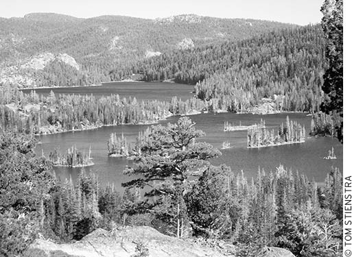
This is a sensational trip, one of the great boat-and-hike adventures in California. You start with a boat taxi across the two Echo Lakes and get dropped off at the trailhead for the Pacific Crest Trail. Then it’s an easy climb to great views with a series of spur trails to beautiful alpine lakes in Desolation Wilderness, crowned by Lake Aloha in Desolation Valley.
From the hiker’s parking lot, walk 0.25 mile downhill to the resort and the boat launch area, at the edge of Echo Lake. The boat taxi leaves at frequent intervals (or whenever more than two people show up) from 8am to 6pm daily all summer. The trip costs $12 each way. The boat carries hikers two miles to the far end of Upper Echo Lake, and the boat ride is unique, too, where you pass many lovely lakeside cottages. You arrive at the border of the Desolation Wilderness, fresh, rested, and ready. If you instead hike the PCT both coming and going, it will add five miles to the trip.
From the boat taxi drop-off point, gain the main trail (Pacific Crest Trail) and head to your left. It’s a 3.5-mile hike to the eastern edge of Lake Aloha. You start with a steady climb up to a ridge. Be sure to stop and turn around to enjoy the stunning lake view. After topping the ridge, the hike is an easy saunter. You’ll pass several signed junctions with numerous trails along the way, all of which lead to various lakes in very short distances. Your best bet is to stay on the main path for Lake Aloha, then take some of the cutoffs to neighboring lakes on your way back. When you reach Lake Aloha’s shore, hike along its beautiful north side for a distance, admiring the rocky coves and islands of the giant, shallow lake. At one time, Lake Aloha was several small lakes. They were dammed with a unique rock wall to create this huge body of water. The effect is a bit surreal, although beautiful. The lake’s elevation is 8,116 feet.
On the trip back, take one or more of the signed trail junctions and visit Lake of the Woods, Lake Lucille, Lake Margery, Tamarack Lake, or Ralston Lake. All are less than one mile off the Lake Aloha Trail. Tamarack Lake is the best for scenery; Lake of the Woods is the best for fishing.
On the return trip, some bypass the boat taxi and continue on the Pacific Crest Trail back to the parking area. That will add 2.5 miles to your trip. The trail rises well above the lake, and eventually you will pass a series of vacation homes.
User Groups: Hikers and dogs (not advised because sharp rocks can bruise their foot pads). No horses or mountain bikes. No wheelchair facilities.
Permits: Boat taxi (not required) is $12 per hiker one-way, $5 for dogs. Permits are required year-round for both day and overnight use. Day hikers may obtain a free permit from a ranger station or may self-issue at most major trailheads. Backpackers camping in Desolation Wilderness are subject to trailhead quotas. There is a $5 reservation fee, plus $5 per person for one night, $10 per person for two or more nights up to 14 days (nonrefundable); reserve at www.recreation.gov. Children ages 12 and under are free. Golden Passes do not apply to personal-use permits. For groups, the cost of a single permit will not exceed $100.
Maps: For a map, ask the U.S. Forest Service for Desolation Wilderness. A Lake Tahoe or Desolation Wilderness map is also available for a fee from Tom Harrison Maps. For a topographic map, ask the USGS for Echo Lake.
Directions: From Placerville, take Highway 50 east for 46 miles to Echo Summit (and Sierra at Tahoe Ski Resort) and then continue east on Highway 50 for 1.8 miles to Johnson Pass Road and a signed turnoff (brown sign) for Berkeley Camp/Echo Lake (one mile west of Echo Summit). Turn left and drive 0.5 mile to Echo Lakes Road. Turn left and drive one mile to a series of parking lots located 0.25 mile before the road ends at Echo Lakes Resort. Hikers not staying at the resort must park in one of the upper lots or alongside the road, not in the main lower lot by the resort, and walk down to the marina, boat taxi, or trailhead.
From South Lake Tahoe: Take Highway 89 south for five miles to U.S. 50. Turn right (west) on U.S. 50 and drive 5.5 miles to the signed turnoff for Echo Lakes on the right (one mile west of Echo Summit). Turn right and drive 0.5 mile to Echo Lakes Road. Turn left and drive one mile to a series of parking lots located 0.25 mile before the road ends at Echo Lakes Resort.
Contact: Echo Lakes Chalet, 530/659-7207, www.echochalet.com; Eldorado National Forest, Pacific Ranger District, 530/644-2349, www.fs.usda.gov/eldorado; Lake Tahoe Basin Management Unit, South Lake Tahoe, 530/543-2600, www.fs.usda.gov/ltbmu; visitors center (open daily mid-June-Sept., Sat.-Sun. Memorial Day-mid-Oct.), 530/543-2674.
32.3 mi one-way/3 days
from Echo Lake to Forest Road 3 near Barker Pass
The Desolation Wilderness (and the neighboring Granite Chief Wilderness) are filled with sculpted granite domes and hundreds of gemlike lakes. All is pristine, yet access is also quite easy, making this, along with the John Muir Trail, the most heavily used section of the PCT. The trip starts at Echo Lake (elevation 7,400 feet), climbs through pines past Upper Echo Lake, and then continues up and north toward Triangle Lake, one of dozens of lakes you pass on your northward route. They come and go in spectacular fashion: Lake Margery, Lake Aloha, and then Heather, Susie, and Gilmore Lakes, and finally Dicks Lake (at 9,380 feet). There are so many, in fact, that you can plan on a perfect campsite near a lake every night, providing you don’t mind the company of other hikers drawn by classic beauty. The views are dramatic as well, across miles and miles of the glacial-carved granite, all of it marvelous high Sierra landscape. As you continue, you’ll discover Upper and Middle Velma Lakes, both very pretty and with good fishing. The trail skirts the ridgeline, keeping the higher knobs to the east as it gradually descends toward Richardson Lake, just beyond the Desolation Wilderness boundary, ready now to enter the Granite Chief Wilderness to the north.
Echo Lakes
To continue north on the PCT, see the Barker Pass to Donner Pass (PCT) hike in this chapter. If you are walking this trail in reverse, see the Carson Pass to Echo Lakes Resort (PCT) hike in this chapter.
User Groups: Hikers, dogs, and horses. No mountain bikes. No wheelchair facilities.
Permits: A backcountry permit is required for traveling through various wilderness and special-use areas the trail traverses. In addition, a campfire permit is required for the use of portable camp stoves or the building of campfires where allowed. To make it simple, you can contact the national forest, Bureau of Land Management (BLM), or national park office at your point of entry for a combined permit that is good for traveling through multiple-permit areas during your dates of travel.
Maps: For topographic maps, ask the USGS for Echo Lake, Emerald Bay, and Rockbound Valley.
Directions: From Placerville, take Highway 50 east for 46 miles to Echo Summit (and Sierra at Tahoe Ski Resort) and then continue east on Highway 50 for 1.8 miles to Johnson Pass Road and a signed turnoff (brown sign) for Berkeley Camp/Echo Lake (one mile west of Echo Summit). Turn left and drive 0.5 mile to Echo Lakes Road. Turn left and drive one mile to a series of parking lots located 0.25 mile before the road ends at Echo Lakes Resort. Hikers not staying at the resort must park in one of the upper lots or alongside the road, not in the main lower lot by the resort, and walk down to the marina, boat taxi, or trailhead.
From South Lake Tahoe: Take Highway 89 south for five miles to U.S. 50. Turn right (west) on U.S. 50 and drive 5.5 miles to the signed turnoff for Echo Lakes on the right (one mile west of Echo Summit.) Turn right and drive 0.5 mile to Echo Lakes Road. Turn left and drive one mile to parking 0.25 mile above Echo Lakes Resort.
To reach the Barker Pass trailhead from Tahoe Pines on Highway 89, head north for 0.5 mile to the Kaspian Picnic Grounds and then bear left (west) for seven miles on Forest Service Road 15N03.
Contact: Echo Lakes Chalet, 530/659-7207, www.echochalet.com; Lake Tahoe Basin Management Unit, South Lake Tahoe, 530/543-2600, www.fs.usda.gov/ltbmu; visitors center (open daily mid-June-Sept., Sat.-Sun. Memorial Day-mid-Oct.), 530/543-2674.
7.6 mi/4.5 hr
in Meiss Country south of Lake Tahoe
Dardanelles Lake is nestled at an elevation of 7,740 feet, set in a pocket with a granite backdrop. It’s striking and gorgeous. This trek provides a tour into “Meiss Country,” that large and wonderful roadless area south of Lake Tahoe. The forces that shaped the land, ice (glaciers) and fire (volcanic action), have made their presence clearly visible.
The route to Dardanelles Lake and Round Lake, along the Tahoe Rim Trail, starts out steep but gets easier as it goes. From the parking lot, the trail heads south, and in about 100 yards crosses Highway 89, then makes an initial climb through fir and pine forest to Big Meadow. The meadow makes lovely, level walking for 0.25 mile; then it’s back into the trees. Follow the trail signs for Round Lake until you complete a steep, short descent at two miles out. At the bottom of the hill, at Meiss Meadow Trail toward Christmas Valley, turn sharply right. Walk less than 0.25 mile, then turn left and cross a creek for the final 1.2 miles to Dardanelles Lake. It’s good for swimming, fishing, and picnicking. If you time your trip for autumn, you’ll be treated to a marvelous color display from the aspens and alders that grow along this trail’s many streams.
On your return, retrace your steps to the junction at the bottom of the hill, then hike 0.75 mile in the opposite direction to visit Round Lake. Although not quite as scenic as Dardanelles Lake, Round Lake provides a stark, fascinating contrast to its neighbor: It is surrounded by volcanic rock formations, not granite cliffs.
Note that this trail is open to mountain bikers. On weekdays you might not see a single bike, but on weekends you’ll see plenty.
User Groups: Hikers, dogs, horses, and mountain bikes. No wheelchair facilities.
Permits: No permits are required. Parking and access are free.
Maps: For a map, ask the U.S. Forest Service for Lake Tahoe Basin Management Unit. A Lake Tahoe map is available for a fee from Tom Harrison Maps. For a topographic map, ask the USGS for Echo Lake.
Directions: From South Lake Tahoe, take Highway 89 south for five miles to Meyers and the junction with Highway 89, and then continue south on Highway 89 for five more miles to the Big Meadow trailhead parking area on the northwest side of the road. Turn left off the highway, then bear left and park near the restrooms. The trail begins from the south side of the parking lot loop and crosses Highway 89 in about 100 yards.
Contact: Lake Tahoe Basin Management Unit, South Lake Tahoe, 530/543-2600, www.fs.usda.gov/ltbmu; visitors center (open daily mid-June-Sept., Sat.-Sun. Memorial Day-mid-Oct.), 530/543-2674.
4.6 mi/3.0 hr
near Carson Pass and Kirkwood Lake
Can you imagine a hike to an alpine lake with only a 500-foot elevation gain? It might seem too good to be true, but here you are. If you need an easy-trail fix, Lake Margaret should do the trick.
The trail undulates gently, never gaining or losing more than a couple hundred feet. The first stretch is actually downhill. Then the path climbs gently over a small ridge and then descends again over granite slabs, where the route is marked with cairns. You’ll cross branches of Caples Creek twice in the first mile. At 1.5 miles, the trail passes by a couple of tiny ponds. At two miles out, after crossing another creek, you’ll find yourself in a lovely grove of aspens and knee-high wildflowers. At 2.3 miles, after about an hour of walking and only a minor expenditure of energy, you’ll reach the granite shoreline of Lake Margaret. Swimming is excellent. A few tiny islands and many shoreline boulders make fine sunbathing spots. Figure on staying awhile. The lake’s elevation is 7,500 feet.
Note that although most of the trails in the Carson Pass area are famous for wildflowers, the proximity of several small streams makes the bloom especially showy on this path. The peak wildflower season is from mid-June to mid-August.
User Groups: Hikers, leashed dogs, horses, and mountain bikes. No wheelchair facilities.
Permits: No permits are required. Parking and access are free.
Maps: For a map, ask the U.S. Forest Service for Eldorado National Forest or Mokelumne Wilderness. For a topographic map, ask the USGS for Caples Lake.
Directions: From South Lake Tahoe, take Highway 89 south for five miles to Meyers and the junction with Highway 89, and then continue south on Highway 89 for 11 miles to Highway 88. Turn west on Highway 88 and drive 14.5 miles to the Lake Margaret sign, on the north side of the road (5.5 miles west of Carson Pass Summit, and 5.5 miles east of Silver Lake.) Turn north and park at the trailhead parking area.
Contact: Eldorado National Forest, Amador Ranger District, 209/295-4251, www.fs.usda.gov/eldorado.
8.0 mi/4.0 hr or 2 days
in the Mokelumne Wilderness near Caples Lake
A climb of less than 1,000 feet leads to gorgeous Emigrant Lake at an elevation of 8,600 feet. The trail starts at the spillway at Caples Lake, along the lake’s south side, and follows a historic emigrant route. The first two miles are right along the lake’s edge, where you climb gently above the shoreline, always in the shade of big conifers. You continue along Emigrant Creek to a stream crossing at 3.5 miles, followed by another crossing. Most of the trail’s ascent is packed into the last 1.8 miles. A few switchbacks ultimately carry you up to Emigrant Lake, a beautiful cirque lake. Covered Wagon Peak and Thimble Peak, at 9,500 feet, rise above the scene. The trail’s total elevation gain is less than 1,000 feet, making this an easy day hike for most, even with its eight-mile distance.
The trailhead at Caples Lake is often jam-packed with backpackers, so do yourself a favor: visit here midweek or in the off-season, or make your trip a day hike instead of an overnighter. Why is this trail so popular? It’s gorgeous and easy compared to other Sierra treks.
User Groups: Hikers, leashed dogs, and horses. No mountain bikes. No wheelchair facilities.
Permits: No day-hiking permits are required. A free wilderness permit is required for overnight stays; it is available from the Amador Ranger Station, the Carson Pass Information Station, or the Eldorado Information Center. Maximum group size for day use is 12. Maximum group size for overnight use is eight. No self-registration is available at the trailhead.
Maps: For a map, ask the U.S. Forest Service for Eldorado National Forest or Desolation Wilderness. For a topographic map, ask the USGS for Caples Lake.
Directions: From South Lake Tahoe, take Highway 89 south for five miles to Meyers and the junction with Highway 89, and then continue south on Highway 89 for 11 miles to Highway 88. Turn west on Highway 88 and drive 14 miles (five miles west of Carson Pass) to the west side of Caples Lake and the trailhead parking area.
Contact: Eldorado National Forest, Amador Ranger District, 209/295-4251, www.fs.usda.gov/eldorado.
7.0 mi/3.5 hr

near Silver Lake
The Minkalo Trail is your best bet from Silver Lake. The trail leads to Granite Lake in one mile and to Plasse’s Resort, on the south side of the lake, in three miles. Why not hike to both, then buy a pizza or a Clif Bar at Plasse’s Resort Trading Post to fuel up for the hike back to the Minkalo trailhead?
Silver Lake is located at an elevation of 7,300 feet along Highway 88. The trailhead is located near the Kit Carson Lodge (see directions). The trail starts out rocky and stays that way for the first 0.25 mile. Cross a bridge over Squaw Creek to a right fork that leads to Plasse’s Resort. Take the left fork first, which heads to Granite Lake. It takes about a 20-minute walk with a moderate climb. It’s a pretty lake and good for swimming. After you’ve visited, return to the trail junction and hike south, soon coming close to the edge of Silver Lake. The trail then provides pretty lake views, including long looks at Treasure Island, Silver Lake’s island. It takes about an hour to reach the campground at Plasse’s, an excellent place for horse lovers (and pizza lovers).
User Groups: Hikers, leashed dogs, horses, and mountain bikes. No wheelchair facilities.
Permits: No permits are required. Parking and access are free.
Maps: For a map, ask the U.S. Forest Service for Eldorado National Forest, or Desolation Wilderness. For a topographic map, ask the USGS for Caples Lake.
Directions: From South Lake Tahoe, take Highway 89 south for five miles to Meyers and the junction with Highway 89, and then continue south on Highway 89 for 11 miles to Highway 88. Turn right (west) on Highway 88 and drive 15.5 miles (10.8 miles west of Carson Pass) to the turnoff for Kit Carson Lodge on the north side of the road. Turn north and drive past Kit Carson Lodge, go left at the first fork, and go right at the second fork, to the parking for Minkalo Trail. (It’s a total of 1.4 miles from Highway 88.) Walk back down the road for about 40 yards to find the trailhead.
Contact: Eldorado National Forest, Amador Ranger District, 209/295-4251, www.fs.usda.gov/eldorado.
2.6 mi/1.5 hr

on Highway 4 near Lake Alpine
We like the way Lake Alpine looks from close up on Lakeshore Trail, but then again, we like the way Lake Alpine looks from far up on Osborne Hill, also known as Osborne Point. A short, healthy climb brings you to the point, from which you can look down at the lake and beyond into the Carson-Iceberg Wilderness. The trail ends there but connects to Emigrant West Trail if you wish to hike farther. In spring, if you’re itching for winter to be over so you can go hiking, Highway 4 is kept open as far as Silvertip Campground, but not always farther east. Thus if the snow is dwindling, you’ll have access to this trailhead often long before you can access the others near Lake Alpine.
User Groups: Hikers, dogs, horses, and mountain bikes. No wheelchair facilities.
Permits: No permits are required. Parking and access are free.
Maps: For a map, ask the U.S. Forest Service for Stanislaus National Forest. For a topographic map, ask the USGS for Tamarack.
Directions: From Angels Camp, take Highway 4 east for 40 miles to Bear Valley. Set your odometer at Bear Valley and drive east on Highway 4 for three miles to the Osborne Ridge trailhead (just east of Silvertip Campground). Take the trail that leads from the south side of the road.
Contact: Stanislaus National Forest, Calaveras Ranger District, 209/795-1381, www.fs.usda.gov/stanislaus.
4.0 mi/2.0 hr
on Highway 4 near Lake Alpine
It’s hard to say which trail is better, Lakeshore Trail or Inspiration Point Trail. To solve the dilemma, hike both of them together. The trip starts with a short walk down a dirt road; then turn right onto a single track. After 10 minutes of hiking through a thick lodgepole pine forest peppered with tiny pinecones, you’re at the edge of Lake Alpine, elevation 7,350 feet. Follow the trail to your left, and in another 10 minutes, you reach a left fork for Inspiration Point (Lakeshore Trail continues straight). You’ll want to head out and back on both trails; it makes no difference which one you take first.
The Lakeshore Trail is flat and stays within 100 feet of the water’s edge, offering many pretty lake views. Eventually the trail meets up with Slick Rock, a four-wheel-drive road, but there’s no need to go that far. Just walk a mile or so to the dam, and then turn around and head back. The Inspiration Point Trail, on the other hand, is more of a workout: a steep one-mile climb to the summit at Inspiration Point, from which you can see for miles. Pick a clear day, and you’ll be pointing out Lake Alpine, Elephant Rock, the Dardanelles, and Spicer Meadow Reservoir.
User Groups: Hikers, dogs, and horses. No mountain bikes. No wheelchair facilities.
Permits: No permits are required. Parking and access are free.
Maps: For a national forest map, ask for Stanislaus National Forest. For a topographic map, ask the USGS for Spicer Meadow Reservoir.
Directions: From Angels Camp, take Highway 4 east for 40 miles to Bear Valley. Set your odometer at Bear Valley and drive east on Highway 4 for 4.3 miles to the Lake Alpine East Shore trailhead turnoff, on the right. Turn right, drive 0.25 mile, and turn right again and drive 0.1 mile past Pine Marten Campground to the signed parking area and the trailhead.
Contact: Stanislaus National Forest, Calaveras Ranger District, 209/795-1381, www.fs.usda.gov/stanislaus.
3.0 mi/1.5 hr
in the Carson-Iceberg Wilderness off Highway 4 near Lake Alpine
The trailhead at Silver Valley Campground is the start of the route to Duck Lake. It’s also one of the busiest trailheads into the Carson-Iceberg Wilderness. The trip to Duck Lake is a great easy hike for families or people just in the mood for a stroll (the more ambitious can continue past the lake on an eight-mile round-trip to Rock Lake). It’s only one mile to reach Duck Lake, but once you’re there, you’ll want to walk the loop trail around its perimeter, which adds another mile to your trip. The area is the site of a historic cow camp, where animals have grazed since the late 19th century. You can examine what’s left of a few early-20th-century cowboy cabins.
User Groups: Hikers, dogs, and horses. No mountain bikes. No wheelchair facilities.
Permits: No day-use permits are required. Parking and access are free.
Maps: For a map, ask the U.S. Forest Service for Stanislaus National Forest or Carson-Iceberg Wilderness. For a topographic map, ask the USGS for Spicer Meadow Reservoir.
Directions: From Angels Camp, take Highway 4 east for 40 miles to Bear Valley. Set your odometer at Bear Valley and drive east on Highway 4 for 4.3 miles to the Lake Alpine East Shore trailhead turnoff on the right. Turn right and continue straight to Silver Valley Campground and the Silver Valley trailhead.
Contact: Stanislaus National Forest, Calaveras Ranger District, 209/795-1381, www.fs.usda.gov/stanislaus.
6.4 mi/3.5 hr

in the Mokelumne Wilderness off Highway 4 near Lake Alpine
Your goal is little Wheeler Lake, a fine overlooked lake (and we’ll explain why). Start at the Woodchuck Basin Trailhead, elevation 7,800 feet. The trail leads into the Mokelumne Wilderness, and after you climb uphill for 1.7 forested miles, you reach a junction where you can go left for Underwood Valley or right for tiny Wheeler Lake. Bear right, pass a Mokelumne Wilderness sign, and in moments, you plummet 1,000 feet in a 1.5-mile descent to Wheeler Lake. Think it over before you go, because you’ll need to regain those 1,000 feet on the way home. That’s why many choose not to do this hike. But if you’re willing to take the plunge, you’re treated to a picturesque, tree- and granite-lined lake, where you can pass the afternoon with little fear that you’ll be bugged by a busload of other hikers.
User Groups: Hikers, leashed dogs, and horses. No mountain bikes. No wheelchair facilities.
Permits: No permits are required. Parking and access are free.
Maps: For a map, ask the U.S. Forest Service for Stanislaus National Forest or Mokelumne Wilderness. For a topographic map, ask the USGS for Spicer Meadow Reservoir.
Directions: From Angels Camp, take Highway 4 east for 40 miles to Bear Valley. Set your odometer at Bear Valley and drive east on Highway 4 for 5.5 miles to the Woodchuck Basin trailhead on the left. Turn left and drive 0.25 mile to the parking area.
Contact: Stanislaus National Forest, Calaveras Ranger District, 209/795-1381, www.fs.usda.gov/stanislaus.
1.0 mi/0.5 hr
in Calaveras Big Trees State Park
The giant sequoia that nobody forgets is what is called the “Discovery Stump. “ Others just call it “The Big Stump. “ It’s the most popular spot in the park. Start at the visitors center, then walk south a short distance past the campfire center, to the stump. It is 24 feet in diameter. Everybody gets their picture taken on it. Here’s the story: Back in the day, a gent wanted to prove how big the trees were to folks on the East Coast, so naturally, he cut the biggest one down, collected the bark and wasted the wood, then took it by railroad to the World’s Fair and reassembled it to prove how big it was. Except everybody thought it was a hoax. Then, shortly thereafter, the bark collection was burned in a fire. Surprised the guy didn’t shoot a Bigfoot while he was at it? The giant stump has been used for just about everything, including a dance floor. According to projections, if it had been allowed to grow, it would be bigger than the General Sherman Tree in Sequoia National Park, the largest living thing by volume on the planet.

North Grove Loop
Once you have seen The Big Stump, which is what we call it, return to the North Grove Loop. It is routed in a loop in a grove of giant sequoias that include several mammoth-sized trees and the Pioneer Cabin Tree. The trail goes right through a cut-off in the Pioneer Cabin Tree, but truth is, the tree is not a tree, but an elongated stump; you can frame pictures to make it look alive by not showing the top.
The easy trail is routed among the giant sequoias, near Big Tree Creek, and back, easy, short and pretty. These trees, of course, are known for their tremendous diameter: It can take a few dozen people, linking hands, to encircle one. This trip is actually best in winter after fresh snowfall, when your footsteps are the only signs of life, and it feels like you are in a time machine. This trail gets very heavy use.
User Groups: Hikers and wheelchairs. No dogs, horses, or mountain bikes.
Permits: No permits are required. A state park entrance fee of $10 is charged each vehicle.
Maps: A brochure and trail map is available for a fee at Calaveras Big Trees State Park. For a topographic map, ask the USGS for Dorrington.
Directions: From Angels Camp, take Highway 4 east for 23 miles to Arnold, and then continue for four miles to the park entrance. The trailhead is adjacent to the park entrance.
Contact: Calaveras Big Trees State Park, 209/795-2334, visitors center, 209/795-3840, www.parks.ca.gov.
5.0 mi/3.0 hr
northeast of Arnold on Highway 4
The two largest sequoias in Calaveras Big Trees State Park are found on a spur trail of this hike, and that makes it a must-do for visitors. But so many tourists are content to just walk the little trail at the North Grove, look at the giant stump and take the trail through the walk-thru tree, and then hit the road. Why rush? As long as you’re at the park, take the South Grove Loop. The loop itself is 3.5 miles long, but the highlight is a spur trail that branches off 0.75 mile to the Agassiz Tree and the Palace Hotel Tree, two monster-sized specimens. For a great photograph, have someone take a picture of you standing at the base of one of these trees; you will look like a Lilliputian from Gulliver’s Travels.
User Groups: Hikers only. No dogs, horses, or mountain bikes. No wheelchair facilities.
Permits: No permits are required. A state park entrance fee of $10 is charged each vehicle.
Maps: A brochure and trail map is available for a fee at Calaveras Big Trees State Park. For a topographic map, ask the USGS for Boards Crossing.
Directions: From Angels Camp, take Highway 4 east for 23 miles to Arnold, and then continue for four miles to the park entrance. Turn right into the park entrance, then drive down the parkway for nine miles to the trailhead, on the right. Note: The road is closed in winter.
Contact: Calaveras Big Trees State Park, 209/795-2334; Columbia State Park, 209/532-0150, www.parks.ca.gov.
15.8 mi one-way/1-2 days
from Carson Pass at Highway 88 north to Echo Lake near U.S. 50, just south of Lake Tahoe
When you’ve hiked on the Pacific Crest Trail for weeks, the first glimpse of Lake Tahoe in the distance can seem like a privileged view into heaven. I’ll never forget it. That view is just a few miles from Ebbetts Pass. You start by hiking over a short mountain rim (nice view to the west of Caples Lake) and then you drop into the headwaters of the Truckee River. As you look northward after making the rim, Lake Tahoe suddenly comes into view. It’s like having a divine vision. And finally there is water available from several small creeks as you walk into the Truckee headwaters. At the same time, you will be greeted by a high meadow surrounded by a light forest. All seems right with the world again. With Echo Lakes Resort within one day’s hiking time, you will be amazed at how inspired (and fast) you can get on this section of trail. It’s very pretty, weaving through lush canyons and along creeks, eventually reaching beautiful and tiny Showers Lake. Here the trail seems to drop off to never-never land; it descends quickly and steeply in the march toward Tahoe. Contentment reigns. When you reach Little Norway, however, reality sets in. Cars are everywhere. The trail suddenly grinds down amid cabins and vacation property. There’s one last hill to climb, a real half hour of frustration–you’re ready for your reward at the store—and then the PCT drops quickly to the parking lot for Echo Lakes.
To continue north on the PCT, see the Echo Lakes Resort to Barker Pass (PCT) hike in this chapter. If you are walking this trail in reverse, see the Blue Lakes Road to Carson Pass (PCT) hike in this chapter.
User Groups: Hikers, dogs, and horses. No mountain bikes. No wheelchair facilities.
Permits: A backcountry permit is required for traveling through various wilderness and special-use areas that the trail traverses. In addition, a campfire permit is required for the use of portable camp stoves or the building of campfires where permitted. To make it simple, you can contact the national forest, Bureau of Land Management (BLM), or national park office at your point of entry for a combined permit that is good for traveling through multiple-permit areas during your dates of travel.
Maps: For national forest maps, ask for Lake Tahoe Basin Management Unit, Tahoe National Forest, Eldorado National Forest, and Stanislaus National Forest. For topographic maps, ask the USGS for Carson Pass, Caples Lake, and Echo Lake.
Directions: To reach the Carson Pass trailhead: From South Lake Tahoe, take Highway 89 south for five miles to Meyers and the junction with Highway 89, and then continue south on Highway 89 for 11 miles to Highway 88. Turn right (west) on Highway 88 and drive 10 miles to Carson Pass.
For the Echo Lakes Resort trailhead: From South Lake Tahoe, take Highway 89 south for five miles to U.S. 50. Turn right (west) on U.S. 50 and drive 5.5 miles to the signed turnoff for Echo Lakes on the right (one mile west of Echo Summit). Turn right and drive 0.5 mile to Echo Lakes Road. Turn left and drive one mile to a series of parking lots located 0.25 mile before the road ends at Echo Lakes Resort. Hikers not staying at the resort must park in one of the upper lots or alongside the road, not in the main lower lot by the resort, and walk down to the marina, boat taxi, or trailhead.
Contact: Eldorado National Forest, Amador Ranger District, 209/295-4251, www.fs.usda.gov/eldorado; Lake Tahoe Basin Management Unit, South Lake Tahoe, 530/543-2600, www.fs.usda.gov/ltbmu; visitors center (open daily mid-June-Sept., Sat.-Sun. Memorial Day-mid-Oct.), 530/543-2674.
10.0 mi/6.0 hr

near Caples Lake in Meiss Country
Here’s a day hike on the Pacific Crest Trail into the land of Meiss Country, that is, the headwaters for the Upper Truckee River. Start this trip at the PCT trailhead on the north side of Carson Pass. You head uphill where you climb through Meiss Pass and then drop into a huge valley basin. Views along the way include Mount Round Top, Elephant Back, and Red Lake Peak, and expand to distant, far-off Lake Tahoe to the north. It’s 2.9 miles to a fork with the Tahoe Rim Trail (TRT), just beyond a crossing of Upper Truckee River (little more than a creek here). While stopping to pump a canteen’s worth of water here, we’ve had hummingbirds come up and eye us from a foot away.
At the fork, stay left on the PCT and TRT, and cross the river again on your way to Showers Lake, 2.1 miles farther. The last half mile of trail is a 350-foot descent to Showers Lake, with 9,590-foot Little Round Top poking up above it to the west. The trail leads along the east side of the lake, where campsites can be found. The lake is set at 8,790 feet and is the highest lake in the Upper Truckee River Basin. It’s very pretty.
By the way, at that fork, the right fork leads 2.2 miles to Round Lake, Meiss Country’s largest lake and a popular destination,
This trip is popular with the horsey set. A separate trail leads to Showers Lake from Schneider Camp, a large horse camp, so weekends bring a fair amount of horse traffic. Also note that the trip begins in Eldorado National Forest, but two-thirds of the trail is within jurisdiction of the Lake Tahoe Basin Management Unit.
Note that no bikes are permitted on the PCT, but we’ve seen plenty of tire tread here on the trail.
User Groups: Hikers, leashed dogs, and horses. No mountain bikes. No wheelchair facilities.
Permits: No permits are required. A $5 parking fee is charged per vehicle.
Maps: For a map, ask the U.S. Forest Service for Eldorado National Forest or Mokelumne Wilderness. For topographic maps, ask the USGS for Caples Lake and Carson Pass.
Directions: From South Lake Tahoe, take Highway 89 south for five miles to Meyers and the junction with Highway 89, and then continue south on Highway 89 for 11 miles to Highway 88. Turn west on Highway 88 and drive 10 miles to Carson Pass Summit. The parking area and Meiss trailhead are on the right (north), across the highway from (and slightly west of) the Carson Pass Information Station.
Contact: Eldorado National Forest, Amador Ranger District, Pioneer, 209/295-4251 www.fs.fed.us/r5.
3.0 mi/1.5 hr

in the Mokelumne Wilderness near Carson Pass
Woods Lake is a little magical spot where you can drive right up, walk a few feet to the water’s edge, and plunk in your fishing line. It’s also the trailhead for numerous great hikes into the Mokelumne Wilderness, including this easy trip to deep blue Winnemucca Lake, set at the base of Mount Round Top (elevation 10,381 feet). From Woods Lake, the trip starts where you walk amid big conifers until you come out to a glacial moraine. A view emerges of Mount Round Top, a huge old volcanic vent. It’s a stunning sight, and in an average winter, collects massive amounts of snow. In early summer, wildflowers bloom in profusion on the open slopes surrounding the path. From Woods Lake, it is only 1.5 miles of gentle to moderate climbing to reach the edge of Winnemucca Lake, nestled at the foot of Mount Round Top.
The land here has been formed by volcanic action, so as you walk, wide-traveled hikers may have to remember that you aren’t at Lassen Peak or Mount Shasta. The beauty attracts a ton of people, often 200 to 300 on summer weekends.
The peak season for wildflowers is mid-June to mid-August, at its very best in mid-to-late July. If you hiked this trail in years past, you may remember that it once started by crossing a footbridge. That is no longer true.
User Groups: Hikers, leashed dogs, and horses. No mountain bikes. No wheelchair facilities.
Permits: A free wilderness permit is required for overnight stays; it is available from the Amador Ranger Station, the Carson Pass Information Station, or the Eldorado Information Center. A parking fee of $5 is charged, good for overnight use.
Maps: For a map, ask the U.S. Forest Service for Mokelumne Wilderness or Eldorado National Forest. For topographic maps, ask the USGS for Caples Lake and Carson Pass.
Directions: From South Lake Tahoe, take Highway 89 south for five miles to Meyers and the junction with Highway 89, and then continue south on 89 for 11 miles to Highway 88. Turn right (west) on Highway 88 and drive 12 miles to the Woods Lake Campground turnoff, on the south side of the road (1.5 miles west of Carson Pass Summit). Turn left and drive one mile to the trailhead parking area (0.5 mile before reaching Woods Lake).
Contact: Eldorado National Forest, Amador Ranger District, 209/295-4251, www.fs.usda.gov/eldorado.
6.6 mi/4.0 hr
in the Mokelumne Wilderness near Carson Pass
The mission on this hike is to connect the trailhead from Woods Lake to Winnemucca Lake and beyond to the top of 10,380-foot Mount Round Top. Your reward is a 10. You pay a bit for your pleasure. Start at the Woods Lake Trailhead, and take the Winnemucca Lake Trail for the first 1.5 miles to Winnemucca’s edge, as described in the previous hike. Then bear right and cross the stream on the west side of the lake. It’s then one mile, uphill, to Round Top Lake, steep enough to get you puffing. The gorgeous volcanic scenery makes it all worthwhile. Round Top Lake is set below The Sisters, two peaks that are both over 10,000 feet high. You also have views of Mount Round Top and Fourth of July Peak. It’s incredibly dramatic.
From the eastern edge of Round Top Lake, you’ll see a path that is routed up the side of Mount Round Top. The grade is brutal, but when you reach the top after a final rocky scramble, you have a stunning view of The Dardanelles, Lake Tahoe, Caples Lake, Woods Lake, Round Top Lake, Winnemucca Lake, and Frog Lake. Summit City Canyon, 3,000 feet below the south side of Round Top, is stunning. At 10,380 feet, Mount Round Top is the highest peak in the Carson Pass area and is the finest place for a bird’s-eye view. The summit is more like a knife-thin, rocky ridge, so watch your footing. This is not a place for children or inexperienced hikers.
After your summit visit, return downhill to Round Top Lake to finish out your loop. Follow the lake’s outlet creek on Lost Cabin Mine Trail for two miles back to Woods Lake Campground; then wind your way through the camp back to the Woods Lake Picnic Area, where you left your car.
User Groups: Hikers, leashed dogs, and horses. No mountain bikes. No wheelchair facilities.
Permits: A free wilderness permit is required for overnight stays; it is available from the Amador Ranger Station, the Carson Pass Information Station, or the Eldorado Information Center. A parking fee of $5 is charged, good for overnight use.
Maps: For a map, ask the U.S. Forest Service for Mokelumne Wilderness or Eldorado National Forest. For topographic maps, ask the USGS for Caples Lake and Carson Pass.
Directions: From South Lake Tahoe, take Highway 89 south for five miles to Meyers and the junction with Highway 89, and then continue south on Highway 89 for 11 miles to Highway 88. Turn right (west) on Highway 88 and drive 12 miles to the Woods Lake Campground turnoff, on the south side of the road (1.5 miles west of Carson Pass Summit). Turn left and drive 1.5 miles to the trailhead parking area, by the picnic area at Woods Lake.
Contact: Eldorado National Forest, Amador Ranger District, 209/295-4251, www.fs.usda.gov/eldorado.
8.8 mi/4.5 hr or 2 days
in the Mokelumne Wilderness near Caples Lake
In some parts of California, the idea of 200 to 300 hikers on a wilderness trail in a single day on a summer weekend is mind-boggling. Yet that is what you get here. Carson Pass and Woods Lake are stellar trailheads, and with several lakes and Mount Round Top so close, the crowds thus arrive. So timing becomes key, along with deciding which way to go. There are so many ways from so many trailheads, including ones at Carson Pass and Upper Blue Lake.
The shortest and most direct route is from Woods Lake trailhead, located 0.5 mile before the Woods Lake Campground and picnic area. This includes a nice stopover at Round Top Lake, two miles in. You pass some old mining cabins before you enter the wilderness boundary. Pass the eastern flank of 9,000-foot Black Butte, an old volcanic vent that is similar in appearance to Mount Round Top a few miles to the east. In less than an hour, you arrive at Round Top Lake, a worthy destination in itself and a good spot for a snack break beneath the sturdy shoulders of the two peaks of The Sisters. It’s only two more miles to Fourth of July Lake, but they are steep and downhill (which means you must climb back out on the way home). This is actually good news: It means you will leave the majority of the crowds behind. Most people give up at Fourth of July Saddle, a rocky overlook that sits 1,000 feet above the lake. In addition to the tough grade, the route is often dusty. At the lake, fishing is good for brook trout, and many campsites can be found near its edge. Late in the summer, a sandy beach gets exposed, good for swimmers.
User Groups: Hikers, leashed dogs, and horses. No mountain bikes. No wheelchair facilities.
Permits: A free wilderness permit is required for overnight stays; it is available from the Amador Ranger Station, the Carson Pass Information Station, or the Eldorado Information Center. A parking fee of $5 is charged, good for overnight use.
Maps: For a map, ask the U.S. Forest Service for Eldorado National Forest or Mokelumne Wilderness. For a topographic map, ask the USGS for Caples Lake.
Directions: From South Lake Tahoe, take Highway 89 south for five miles to Meyers and the junction with Highway 89, and then continue south on Highway 89 for 11 miles to Highway 88. Turn right (west) on Highway 88 and drive 12 miles to the Woods Lake Campground turnoff, on the south side of the road (1.5 miles west of Carson Pass Summit). Turn left and drive one mile to the trailhead (0.5 mile before the campground and picnic area).
Contact: Eldorado National Forest, Amador Ranger District, 209/295-4251, www.fs.usda.gov/eldorado.
1.8 mi/1.0 hr
in the Mokelumne Wilderness near Carson Pass
Any hiking trip from the Carson Pass trailhead is going to be packed with people. So it is here, with 200-plus people out on weekends. That known, this trail is educational and beautiful. The short walk to Frog Lake is suitable even for small children (and if you’re more ambitious, you can continue another 1.5 miles to beautiful Winnemucca Lake). At Frog Lake, you are provided with a fascinating look at Elephant Back (elevation 9,585 feet), which looks exactly like its name. It’s a lava dome, a round mass of solid lava. The lake is a beautiful turquoise color, perfect for picnicking, although because the area is rather open and exposed, the wind sometimes blows with ferocity.
Plenty of people take this walk in early summer to see the wildflowers, especially lupine and Indian paintbrush, from mid-June to mid-August (best in late July). A huge patch of wild iris also blooms alongside Frog Lake. It’s a sight to behold. There are many other species of wildflowers here. An identification sheet is posted at the billboard near the trailhead and at the visitors center.
At the visitors center, you can learn about Kit Carson, the great explorer for whom this pass was named, and you can learn about the geologic forces that shaped this region, which is called the Round Top Geologic Area. Evidence of both glacial and volcanic action can be seen with every step you take.
User Groups: Hikers, leashed dogs, and horses. No mountain bikes. No wheelchair facilities.
Permits: A free wilderness permit is required for overnight stays between April 1 and November 30; it is available from the Amador Ranger Station, the Carson Pass Information Station, or the Eldorado Information Center. A $5 parking fee is charged per vehicle.
Maps: For a map, ask the U.S. Forest Service for Eldorado National Forest or Mokelumne Wilderness. For a topographic map, ask the USGS for Carson Pass.
Directions: From South Lake Tahoe, take Highway 89 south for five miles to Meyers and the junction with Highway 89, and then continue south on Highway 89 for 11 miles to Highway 88. Turn right (west) on Highway 88 and drive 10 miles to Carson Pass Summit. The parking area and trailhead are on the left, by the Carson Pass Information Station.
Contact: Eldorado National Forest, Amador Ranger District, 209/295-4251, www.fs.usda.gov/eldorado.
11.0 mi/1-2 days
in the Mokelumne Wilderness near Blue Lakes
Raymond Lake is a popular weekend trip despite the 3,000-foot climb. The pretty campsites at the little lake are used by PCT hikers and weekenders who make this a two-day in-and-outer. That is, about five miles in and about five miles out, and that’s why it works, especially for couples or young families new to backpacking. The lake is about 10 acres in size and is set at 9,000 feet, with several small campsites sprinkled near the lake. The trail starts near Wet Meadows Reservoir and heads east from the access road on the Pacific Crest Trail. It follows the PCT for 4.5 miles, a moderate ascent, to the junction with the Raymond Lake Trail. Turn right for the final mile. This final stretch is only a mile but is a butt-kicker, mostly because you’re already getting tired when you begin it. The lake is set below 10,000-foot Raymond Peak, an alpine peak.
User Groups: Hikers, dogs, and horses. No mountain bikes. No wheelchair facilities.
Permits: A free wilderness permit is required for overnight stays; it is available on the wilderness bulletin board at the trailhead, from the ranger station in Markleeville, the Carson Pass Information Station, or the Carson Ranger district in Carson City. Groups are limited to 12, and no campfires are permitted above 8,000 feet.
Maps: For a map, ask the U.S. Forest Service for Humboldt-Toiyabe National Forest, Carson District. For topographic maps, ask the USGS for Pacific Valley and Ebbetts Pass.
Directions: From South Lake Tahoe, take Highway 89 south for five miles to Meyers and the junction with Highway 89, and then continue south on Highway 89 for 11 miles to Highway 88. Turn right (west) on Highway 88 and drive 2.5 miles to the Blue Lakes turnoff, on the south side of the road. Turn south and drive 11 miles to the left turnoff for Tamarack Lake and Wet Meadows. Bear left and drive three miles to the left turnoff for Lower Sunset Lake. Turn left and drive a short distance to the trailhead.
Contact: Humboldt-Toiyabe National Forest, 775/331-6444, www.fs.usda.gov/htnf.
4.0 mi/2.0 hr
in the Mokelumne Wilderness near Blue Lakes
The trip starts at the dam at Upper Blue Lake. A well-signed and meandering route ventures one mile to enter the Mokelumne Wilderness. Another mile beyond the wilderness boundary is Granite Lake. To reach it requires a total 550-foot climb, but the trail is well graded and some will barely notice they are climbing. Note that a quarter mile past the boundary sign, you’ll see a large pond, but don’t mistake that for Granite Lake, which is another 20 minutes farther on the trail. When you arrive, you’ll find this small lake set in a granite pocket. Don’t be concerned if there are lots of cars in the dam parking lot. Most of them belong to anglers, not hikers.
User Groups: Hikers, leashed dogs, and horses. No mountain bikes. No wheelchair facilities.
Permits: A free wilderness permit is required for overnight; it is available from the Amador Ranger Station, the Carson Pass Information Station, or the Eldorado Information Center.
Maps: For a map, ask the U.S. Forest Service for Eldorado National Forest. For a topographic map, ask the USGS for Pacific Valley.
Directions: From South Lake Tahoe, take Highway 89 south for five miles to Meyers and the junction with Highway 89, and then continue south on Highway 89 for 11 miles to Highway 88. Turn right (west) on Highway 88 and drive 2.5 miles to the Blue Lakes turnoff, on the south side of the road. Turn south and drive 12 miles to the fork at Lower Blue Lake. Turn right and drive 1.5 miles to the dam by Upper Blue Lake, shortly past Middle Creek Campground; turn left into the parking area. The Grouse Lake Trail leads to Granite Lake from the west side of the parking area.
Contact: Eldorado National Forest, Amador Ranger District, 209/295-4251, www.fs.usda.gov/eldorado.
3.0 mi/1.5 hr
in Grover Hot Springs State Park near Markleeville
Your goal is a 50-foot waterfall, best in spring and early summer, of course. The route is a bit tricky, but even without a waterfall, this would be a great trail to walk. The route starts from just beyond the campgrounds in Grover Hot Springs State Park, an elevation of 5,900 feet. From here, you hike on the Burnside Lake and Charity Valley Trails for 0.5 mile, then reach a fork signed for the waterfall. Turn left at the fork, and in the process, some newcomers get confused where you reach a jumbled pile of boulders on the trail. Simply go up and over them. Hot Springs Canyon gradually narrows on its way to the falls, and when you near the creek’s edge, you might see small trout swimming in its pools. You then arrive at the waterfall, perched at an elevation of 6,200 feet. Technically it is outside of state parkland and in Humboldt-Toiyabe National Forest, so you’ll see backpackers’ campfire rings on the cliff above the falls.
Highlights of the trail include the giant Jeffrey pines of Hot Springs Valley, enclosed by rocky cliffs and 10,000-foot peaks.
User Groups: Hikers and leashed dogs (not recommended). No horses or mountain bikes. No wheelchair facilities.
Permits: No permits are required. A day-use fee of $8 is charged per vehicle; there is a fee of $7 per person for use of the hot springs pool.
Maps: A map of Grover Hot Springs State Park is available for a fee at the entrance station. For a topographic map, ask the USGS for Markleeville.
Directions: From South Lake Tahoe, take Highway 89 south for five miles to Meyers and the junction with Highway 89, and then continue south on Highway 89 for 11 miles to Highway 88. Turn left on Highway 88/89 and drive 13 miles to Markleeville at Hot Springs Road. Turn right (west) on Hot Springs Road and drive 3.5 miles to the state park entrance. The signed trailhead is 0.25 mile beyond the entrance station and campground turnoffs, at a gated dirt road.
Contact: Grover Hot Springs State Park, 530/694-2248, pool information 530/694-2249, www.parks.ca.gov.
8.4 mi/5.0 hr
in Humboldt-Toiyabe National Forest near Markleeville
From Grover Hot Springs State Park, at 5,900 feet, the Burnside Lake Trail leaves in elevation and climbs west to Burnside Lake, at 8,160 feet, a gain of 2,260 feet. The climb is spaced out over four miles, so it’s a steady workout to the lake. Along the way, you pass tall and majestic sugar pines and rocky outcrops, with 10,023-foot Hawkins Peak and 9,417-foot Markleeville Peak towering over the scene. The lake is about 10 surface acres and is popular for trout fishing. Although you can start hiking on the trail from Hot Springs Road shortly before the state park entrance, it’s best to start from the trailhead at the park. That shaves one mile off your trip, but also when you return from your hike, you can take a dip in the 102- to 104-degree hot springs. At first you may encounter mountain bikers on the trail; they will soon branch off on their way to Charity Valley, a great mountain bike trek.
User Groups: Hikers, dogs, horses, and mountain bikes. No wheelchair facilities.
Permits: No permits are required. A day-use fee of $8 is charged per vehicle at Grover Hot Springs State Park; there is a fee of $7 per person for use of the hot springs pool.
Maps: For a map, ask the U.S. Forest Service for Humboldt-Toiyabe National Forest, Carson District. A map of Grover Hot Springs State Park is available for a fee at the entrance station. For a topographic map, ask the USGS for Markleeville.
Directions: From South Lake Tahoe, take Highway 89 south for five miles to Meyers and the junction with Highway 89, and then continue south on Highway 89 for 11 miles to Highway 88. Turn left on Highway 88/89 and drive 13 miles to Markleeville at Hot Springs Road. Turn right (west) on Hot Springs Road and drive 3.5 miles to the state park entrance. The signed trailhead is 0.25 mile beyond the entrance station and campground turnoffs, at a gated dirt road. Another trailhead is located outside the state park on Hot Springs Road, 0.75 mile before the state park entrance, and is signed for Charity Valley and gets heavy mountain bike use.
Contact: Grover Hot Springs State Park, Markleeville, 530/694-2248 or 530/525-7232, www.parks.ca.gov; Humboldt-Toiyabe National Forest, 775/331-6444, www.fs.usda.gov/htnf.
12.0 mi one-way/1 day
from Blue Lakes Road north to Carson Pass and Highway 88
Many hikers underestimate the climb over Elephant Back to reach Carson Pass. After all, on a map, it doesn’t look like much, and from a distance, as you size it up, it looks easy enough. Wrong. It’s a long, grueling pull. The trip out of Blue Lakes starts easily, with a dirt road often in view and adding a bit of early angst to the affair. As you go, you keep wondering when the climb will start. Well, eventually it does, and, alas, it takes a couple of hours, a long, steady march. After topping the Elephant Back, the route drops down to Carson Pass at a rest stop, where you’ll likely meet humanity, but believe it or not, no water! When we hiked from Yosemite to Tahoe, this was the worst shock of the trip. Conserve yours if you plan to go onward, because it takes another hour of hiking before you’ll reach the next trickle.
To continue north on the PCT, see the Carson Pass to Echo Lakes Resort (PCT) hike in this chapter. If you are walking this trail in reverse, see the Ebbetts Pass to Blue Lakes Road (PCT) hike in this chapter.
User Groups: Hikers, dogs, and horses. No mountain bikes. No wheelchair access.
Permits: A backcountry permit is required for traveling through various wilderness and special-use areas that the trail traverses. In addition, a campfire permit is required for the use of portable camp stoves or the building of campfires where allowed. To make it simple, you can contact the national forest, Bureau of Land Management (BLM), or national park office at your point of entry for a combined permit that is good for traveling through multiple-permit areas during your dates of travel.
Maps: For a map, ask the U.S. Forest Service for Lake Tahoe Basin Management Unit, Tahoe National Forest, Eldorado National Forest, and Stanislaus National Forest. For topographic maps, ask the USGS for Pacific Valley and Carson Pass.
Directions: To reach the Blue Lakes Road trailhead from the Highway 88/89 junction at Hope Valley, go west on Highway 88 to Blue Lakes Road and turn left. Stay on Blue Lakes Road for 11 miles to the trailhead parking, just before reaching Blue Lakes.
For the Carson Pass trailhead from the Highway 88/89 junction at Hope Valley, go west on Highway 88 to Carson Pass.
Contact: Eldorado National Forest, Amador Ranger District, 209/295-4251, www.fs.usda.gov/eldorado.
5.0 mi/2.5 hr
in Humboldt-Toiyabe National Forest near Ebbetts Pass
From the Ebbetts Pass trailhead, Kinney Lakes is an easy tromp north on the Pacific Crest Trail. You pass little Sherrold Lake on the way to Upper Kinney Lake (which is actually a reservoir).
You start hiking at 8,700 feet at the pass, so even though this trail has an easy to moderate grade, your lungs are getting a workout. The trail leads through a landscape of big conifers with little undergrowth, typical of the high country. When the trees thin out, your views open wide. Raymond Peak and Reynolds Peak rule the skyline. At 1.6 miles, you reach a signed junction for Upper and Lower Kinney Lakes, and you can take your pick as to which one to visit first. The Pacific Crest Trail leads directly to the upper lake, while the lower lake must be visited by following an eastward fork from the PCT. The upper lake, though smaller, is the prettier of the two.
User Groups: Hikers, dogs, and horses. No mountain bikes. No wheelchair facilities.
Permits: Wilderness permits are required for overnight use. No campfires are allowed above 8,000 feet. Parking and access are free.
Maps: For a map, ask the U.S. Forest Service for Humboldt-Toiyabe National Forest, Carson District. For a topographic map, ask the USGS for Ebbetts Pass.
Directions: From Angels Camp, drive east on Highway 4 for about 40 miles to Bear Valley. Set your odometer at Bear Valley, and drive 15 miles farther east on Highway 4 to Ebbetts Pass and the trailhead parking area. The trail is on the north side of the road.
If you are coming from Markleeville, drive south on Highway 89/Highway 4 for 15 miles to Ebbetts Pass.
Contact: Humboldt-Toiyabe National Forest, 775/331-6444, www.fs.usda.gov/htnf.
17.7 mi one-way/1 day
from Highway 4 near Ebbetts Pass to Blue Lakes Road south of Carson Pass and Highway 88
As you leave Ebbetts Pass and head north, you’ll cross a series of fantastic volcanic formations in the Mokelumne Wilderness. The country here may look stark from a distance, but it is loaded with tiny wildflowers in every ravine. The trail is easy without a lot of climb and descent, then repeat; and a lot of hikers make great time in this area. The lack of available water can become a concern. Tank up whenever you get the chance, such as at Eagle Creek below Reynold Peak (9,690 feet). The Mokelumne Wilderness is a relative breeze, and you’ll find yourself approaching civilization at a series of small lakes in Tahoe National Forest. The trail rises up a stark, wind-blown, sandy ridge, with excellent views of the Blue Lakes, but again, there is no water for several miles until you drop down near Lost Lake. You’ll actually cross several roads on this stretch of trail, and maybe even see a car, a moment of irony for long-distance PCT hikers. But the going is easy; we think this is one of the fastest sections of the PCT in the central Sierra. To continue north on the PCT, see the Blue Lakes Road to Carson Pass (PCT) hike in this chapter.
User Groups: Hikers, dogs, and horses. No mountain bikes. No wheelchair facilities.
Permits: A backcountry permit is required for traveling through various wilderness and special-use areas that the trail traverses. In addition, a campfire permit is required for the use of portable camp stoves or the building of campfires (where permitted). To make it simple, you can contact the national forest, Bureau of Land Management (BLM), or national park office at your point of entry for a combined permit good for traveling through multiple-permit areas during your dates of travel.
Maps: For a map, ask the U.S. Forest Service for Lake Tahoe Basin Management Unit, Tahoe National Forest, Eldorado National Forest, and Stanislaus National Forest. For topographic maps, ask the USGS for Ebbetts Pass, Pacific Valley, and Carson Pass.
Directions: To reach the Ebbetts Pass trailhead from Angels Camp, head east on Highway 4 to Ebbetts Pass.
To reach the Blue Lakes Road trailhead from the Highway 88/89 interchange at Hope Valley, head west on Highway 88 to Blue Lakes Road and turn left. Stay on Blue Lakes Road to the trailhead parking area, just before reaching Blue Lakes.
Contact: Eldorado National Forest, Amador Ranger District, 209/295-4251, www.fs.usda.gov/eldorado.
9.0 mi/4.5 hr
in Humboldt-Toiyabe National Forest near Ebbetts Pass
Noble Lake lies just outside of the Carson-Iceberg Wilderness. You can best reach it with a gentle route from Ebbetts Pass.
From Ebbetts Pass (elevation 8,700 feet), there’s a 1,200-foot climb to the lake at 9,440 feet (which includes some ups and downs). The lake is a fine spot for camping or just spending an afternoon. It is not pristine gorgeous, but is an 8, classic high Sierra, with big conifers, snowcapped peaks, hard granite, and lush meadows.
From the trailhead parking area, the route follows a short 0.25-mile spur trail that climbs a short distance, then connects to the Pacific Crest Trail. You head south, of course, first climbing to a short ride, and then you make a long descent into Noble Canyon. At three miles, you will cross Noble Creek and then climb again to a high meadow. Soon you can see Noble Lake; the main lake is to the right of the trail, but a smaller, unnamed lake is to the left, about 650 feet off the trail. Both have decent campsites and many good rocks to sit on and relax.
A boulder field above the campsites is loaded with ground squirrels, and if you hike overnight here with a dog, the squirrels will drive your dog crazy. I don’t think Bart-Dog went to sleep the whole night. This lake is excellent for swimming but poor for fishing. For camping, group size is limited to 15 people, and a 100-foot setback from the lake is required.
User Groups: Hikers, dogs, and horses. No mountain bikes. No wheelchair facilities.
Permits: No day-hiking permits are required. A free wilderness permit is available at the trailhead (self-issue). Parking and access are free.
Maps: For a map, ask the U.S. Forest Service for Humboldt-Toiyabe National Forest, Carson District. For a topographic map, ask the USGS for Ebbetts Pass.
Directions: From Angels Camp at the intersection of Highways 4 and 49, go east on Highway 4 for 40 miles to Bear Valley. Set your odometer at Bear Valley, and drive 15 miles farther east on Highway 4 to Ebbetts Pass and the trailhead parking area (located just east of Ebbetts Pass; do not park on Highway 4). The trailhead is on the south side of the road.
Contact: Humboldt-Toiyabe National Forest, 775/331-6444, www.fs.usda.gov/htnf.
9.6 mi/5.0 hr
in the Carson-Iceberg Wilderness near Markleeville
When fed by snowmelt, Wolf Creek Falls thunders over a volcanic cliff. That’s your pay-off, and amid the crowds in the Tahoe region, there’s a good chance you’ll have it to yourself. The trailhead is at an elevation of 6,480 feet. The trail is an old jeep road that is routed along Wolf Creek, uphill through forest, and in turn, provides shade most of the way. Wolf Creek is very pretty, especially when the sun catches it just right. Hike 4.3 miles out to a fork for the steep Bull Canyon Trail to Bull Lake. Bear left and continue 0.5 mile to Wolf Creek Falls. The waterfall is located just off the trail to the left, about 50 yards beyond where the trail passes through a cattle fence. For waterfall lovers, this one is impressive early in the summer.
User Groups: Hikers, dogs, and horses. No mountain bikes. No wheelchair facilities.
Permits: A free wilderness permit is required for overnight stays; it is available at the trailhead. Parking and access are free.
Maps: For a map, ask the U.S. Forest Service for Humboldt-Toiyabe National Forest, Carson District, and Carson-Iceberg Wilderness. For a topographic map, ask the USGS for Wolf Creek.
Directions: From South Lake Tahoe, take Highway 89 south for five miles to Meyers and the junction with Highway 89, and then continue south on Highway 89 for 11 miles to Highway 88. Turn left on Highway 88/89 and drive 13 miles to Markleeville. From Markleeville, continue south on Highway 89 for four miles to Monitor Pass Junction and Highway 4. Bear right (south) on Highway 4 and drive 2.5 miles to the signed turnoff for Wolf Creek, on the left. Turn left (south) and drive 4.9 miles to the trailhead, about 100 yards before the end of the road.
Contact: Humboldt-Toiyabe National Forest, 775/331-6444, www.fs.usda.gov/htnf.
4.0 mi/2.0 hr

in the Carson-Iceberg Wilderness near Markleeville
The East Carson River Trail can be your salvation in spring when there’s still too much snow around Ebbetts Pass. Trailhead elevation is only 6,240 feet at the north side of Wolf Creek Meadows (private property), which means it’s snow-free before other nearby areas. At the start, you hike uphill a short distance to a trail junction and the boundary sign for the Carson-Iceberg Wilderness. Turn left (the right fork is the High Trail northern terminus). An interesting journey is 1.5 miles to Wolf Creek Lake (sometimes dry) and Railroad Canyon, the site of 19th-century logging operations.
User Groups: Hikers, dogs, and horses. No mountain bikes. No wheelchair facilities.
Permits: A free wilderness permit is required for overnight stays; it is available at the trailhead. Parking and access are free.
Maps: For a map, ask the U.S. Forest Service for Humboldt-Toiyabe National Forest, Carson District, and Carson-Iceberg Wilderness. For a topographic map, ask the USGS for Wolf Creek.
Directions: From South Lake Tahoe, take Highway 89 south for five miles to Meyers and the junction with Highway 89, and then continue south on Highway 89 for 11 miles to Highway 88. Turn left on Highway 88/89 and drive 13 miles to Markleeville. Continue south on Highway 89/Highway 4 for 7.5 miles to the signed turnoff for Wolf Creek on the left. Turn left (east) and drive 3.5 miles to the left turnoff signed for East Carson River Trail. Turn left and drive one mile to the road junction to Dixon Mine. Turn right and drive 0.25 mile to the trailhead.
Contact: Humboldt-Toiyabe National Forest, 775/331-6444, www.fs.usda.gov/htnf.
4.8 mi/2.5 hr
in the Carson-Iceberg Wilderness near Ebbetts Pass
The trailhead at Mosquito Lakes, perched at an elevation of 8,000 feet on Highway 4, is gorgeous. You know you’re in for a good trip when the trailhead is located at such a pretty spot. And so it is here. The trail climbs and descends, then climbs and descends some more, mostly heading in a straight-line course due south to Heiser Lake. It’s one of those rare trails where you’ve got to work equally hard whether on the way in or on the way out. Two miles in, at a junction with the trail from Bull Run Lake, bear left and finish out the last 0.5 mile to Heiser Lake, set at 8,300 feet. The lake is granite bound, with a couple of tiny islands sticking out of its shallow waters. Quiet, pristine, gorgeous.
User Groups: Hikers, dogs, and horses. No mountain bikes. No wheelchair facilities.
Permits: No day-hiking permits are required. Parking and access are free.
Maps: For a map, ask the U.S. Forest Service for Stanislaus National Forest and Carson-Iceberg Wilderness. For topographic maps, ask the USGS for Pacific Valley and Spicer Meadow Reservoir.
Directions: From Angels Camp, take Highway 4 east for 40 miles to Bear Valley. Set your odometer at Bear Valley and drive 10 miles farther east on Highway 4 to the Mosquito Lakes trailhead and Heiser Lake Trail. Park on the right (south) side of the road, across from the campground; there is only enough space for a few cars.
Contact: Stanislaus National Forest, Calaveras Ranger District, 209/795-1381, www.fs.usda.gov/stanislaus.
7.0 mi/4.0 hr
in the Carson-Iceberg Wilderness near Ebbetts Pass
The hike to Bull Run Lake can be a side trip or an option to nearby Heiser Lake (see previous listing). The lake is set at 8,300 feet and is a fine reward for your effort. It is gorgeous, set in a steep-walled granite bowl. Plus, this trail to Bull Run Lake is well graded, with one steep section in the last 0.5 mile. The trailhead is set at 7,800 feet. The first 1.3 miles are almost level, traveling slightly downhill through a grassy meadow that is filled with wildflowers in the early summer and turns golden by September. After that, you start to climb, mostly through pine forest and over stretches of granite with trail cairns. At 2.2 miles, watch for a trail junction. Turn right for Bull Run Lake (straight ahead, on the other hand, is Heiser Lake). After a brief flat stretch, prepare for a final mile of climbing, with the last part the steepest.
On summer weekends, you might have to share the trail to Bull Run Lake with some horses. After all, their owners like the big parking lot at the trailhead, large enough for horse trailers. Maybe you should pack along a few extra apples or carrots, eh?
User Groups: Hikers, dogs, and horses. No mountain bikes. No wheelchair facilities.
Permits: No day-hiking permits are required. Parking and access are free.
Maps: For a map, ask the U.S. Forest Service for Stanislaus National Forest or Carson-Iceberg Wilderness. For topographic maps, ask the USGS for Pacific Valley and Spicer Meadow Reservoir.
Directions: From Angels Camp, take Highway 4 east for 40 miles to Bear Valley. Set your odometer at Bear Valley and drive 8.5 miles farther east on Highway 4 to the Stanislaus Meadow turnoff, on the right (Road 8N13). Turn right and drive a short distance to the trailhead parking area.
Contact: Stanislaus National Forest, Calaveras Ranger District, 209/795-1381, www.fs.usda.gov/stanislaus.
8.0 mi/4.0 hr
in the Carson-Iceberg Wilderness on Clark Fork Stanislaus River
The pay-offs on this hike include a trail along the beautiful Clark Fork Stanislaus River and then a climb along a pretty creek to little Boulder Lake. The trailhead is at Iceberg Meadow. You immediately enter the Carson-Iceberg Wilderness at the base of imposing Iceberg Peak. The trail starts where you hike upstream on the northern edge of the Clark Fork. This is a good trout stream, and through early summer, wildflowers are abundant amid a mixed forest of white firs and Jeffrey pines. At the water’s edge, the trees are leafier, including cottonwoods and aspens. At 2.5 miles you reach a junction near Boulder Creek. To reach Boulder Lake, turn left (straight takes you along the Clark Fork). The trail then climbs, steep at times, for 1.5 miles uphill to tiny Boulder Lake. It’s a good workout to a pretty destination.
User Groups: Hikers, dogs, and horses. No mountain bikes. No wheelchair facilities.
Permits: A free wilderness permit is required for overnight stays and is available from the Summit Ranger Station. Parking and access are free.
Maps: For a map, ask the U.S. Forest Service for Stanislaus National Forest or Carson-Iceberg Wilderness. For a topographic map, ask the USGS for Donnell Lake.
Directions: From Sonora, take Highway 108 east for 46 miles to the left turnoff for Clark Fork Road (about 17 miles east of Strawberry). Turn left and follow Clark Fork Road for about seven miles to its end, at the Clark Fork trailhead at Iceberg Meadow.
Contact: Stanislaus National Forest, Summit Ranger District, 209/965-3434, www.fs.usda.gov/stanislaus.
3.0 mi/1.5 hr
near Strawberry and Pinecrest Lake in Stanislaus National Forest
If this trail was called “Edge of the World, “ it would give you just what you might expect. The trailhead is in the middle of a 1.5-mile trail, which means you’ll walk out and back in both directions. It starts out nondescript, but that quickly changes. The gargoyles—odd rock formations—soon line the trail, perched at the edge of a cliff at 7,400 feet in elevation. You walk just inches away from what appears to be the edge of the world, with only thin air between you and the densely forested basin several hundred feet below. It’s an easy and nearly flat trail, but if you have kids, or adults that act like kids, keep an eye on them.
User Groups: Hikers and leashed dogs. No horses or mountain bikes. No wheelchair facilities.
Permits: No permits are required. Parking and access are free.
Maps: For a map, ask the U.S. Forest Service for Stanislaus National Forest. For a topographic map, ask the USGS for Pinecrest.
Directions: From Sonora, take Highway 108 east for 32 miles to Strawberry, and then continue east 2.4 miles to Herring Creek Road (Forest Road 4N12). Turn right on Herring Creek Road and drive 6.7 miles to an often-unsigned turnoff on the left. Turn left and drive 0.2 mile to the trailhead.
Contact: Stanislaus National Forest, Summit Ranger District, 209/965-3434, www.fs.usda.gov/stanislaus.
0.5 mi/0.5 hr
near Dardanelle
This is the central Sierra’s answer to Devils Postpile National Monument. The Columns of the Giants features rock columns that are 30-40 feet in height and 3-4 feet in diameter. Although many are still standing tall or at least at an angle, others have shattered into thousands of pieces, creating a giant pile of rubble, at times just a jumbled heap of rocks. An interpretive trail sign explains that underneath this rock pile is evidence of the last small ice age in the Sierra, frozen remnants of ice fields that are replenished each year by winter snow and cold. The rock formations at the end of the Columns of the Giants geological trail were formed 150,000 years ago, when a series of volcanic eruptions occurred. The lava flow cooled rapidly, probably during cold weather, and cracked into narrow, hexagonal, basalt columns. Make sure you bring your camera.
User Groups: Hikers and leashed dogs. No horses or mountain bikes. No wheelchair facilities.
Permits: No permits are required. Parking and access are free.
Maps: For a map, ask the U.S. Forest Service for Stanislaus National Forest. For a topographic map, ask the USGS for Dardanelle.
Directions: From Sonora, take Highway 108 east for 50 miles to Pigeon Flat Campground (two miles east of Dardanelle) on the south side of the highway. If you’re traveling west on Highway 108, the campground is 12.6 miles west of Sonora Pass. Park in the day-use parking lot just outside the camp.
Contact: Stanislaus National Forest, Summit Ranger District, 209/965-3434, www.fs.usda.gov/stanislaus.
14.8 mi/2 days
in the Emigrant Wilderness near Dardanelle
Follow the trail notes to Relief Reservoir (see listing in this chapter), but at 2.6 miles, take the left fork for Kennedy Lake. The trail climbs for another 1.6 miles, then goes flat for the final 3.2 miles to the lake. It’s an easy two-day backpack trip, with low mileage and only a 1,200-foot elevation gain. Note that all the campsites are set downstream of the lake rather than along its shoreline.
If the number of cars in the Kennedy Meadows parking lot scares you, take heart. Many of them belong to people day hiking to fish at Relief Reservoir. If you have the time and inclination for a longer trip to Kennedy Lake, you will leave a lot of your fellow hikers behind. Even so, don’t expect solitude. You’ll likely share the lake with other backpackers, horse packers, and grazing cows.
User Groups: Hikers, leashed dogs, and horses. No mountain bikes. No wheelchair facilities.
Permits: A free wilderness permit is required for overnight stays and is available from the Summit Ranger Station. Parking and access are free.
Maps: For a map, ask the U.S. Forest Service for Stanislaus National Forest or Emigrant Wilderness. For a topographic map, ask the USGS for Sonora Pass.
Directions: From Sonora, take Highway 108 east for 55 miles to the turnoff for Kennedy Meadows (six miles east of Dardanelle) on the south side of the highway. Turn right and drive one mile to the large parking area. If you’re traveling west on Highway 108, the Kennedy Meadows turnoff is 9.1 miles west of Sonora Pass.
Contact: Stanislaus National Forest, Summit Ranger District, 209/965-3434, www.fs.usda.gov/stanislaus.
6.0 mi/3.0 hr
on the edge of the Emigrant Wilderness near Dardanelle
At Kennedy Meadows along Highway 108, the trips starts from a mammoth trailhead and parking lot. At peak use, the number of vehicles might have you shaking your head. Many visitors take the three-mile trip to Relief Reservoir (elevation 7,200 feet), a PG&E lake, to do a little fishing, then hike back out. The Emigrant Wilderness is best known for its miles of high granite and small lakes in deep pockets. Relief Reservoir is the most popular.
The route is called the Huckleberry Trail and leads along the Stanislaus River. It passes the boundary for the Emigrant Wilderness at one mile, then skirts its edge. You will quickly understand why this trip is so popular. The river canyon gets more and more beautiful as you head deeper into it. The trail had to be blasted into the steep granite slopes. At 2.6 miles, you will pass a turnoff (on the left for Kennedy Creek and Kennedy Lake), and then proceed straight for another 0.5 mile to an overlook of Relief Reservoir. It’s a steep drop down to the water’s edge in the last 0.25 mile, which, of course, must be regained on the return trip.
At times, horses can chop up the trail, and the route is overused; a trail quota would help. Some weekends it seems you must pull off the path repeatedly to let horses pass.
User Groups: Hikers, leashed dogs, and horses. No mountain bikes. No wheelchair facilities.
Permits: No day-use permits are required. Parking and access are free.
Maps: For a map, ask the U.S. Forest Service for Stanislaus National Forest or Emigrant Wilderness. For a topographic map, ask the USGS for Sonora Pass.
Directions: From Sonora, take Highway 108 east for 55 miles to the Kennedy Meadows turnoff (six miles east of Dardanelle) on the south side of the highway. Turn right and go one mile to the well-signed parking area. Day hikers can park 0.5 mile farther down the road, near Kennedy Meadows Resort. If you’re traveling west on Highway 108, the Kennedy Meadows turnoff is 9.1 miles west of Sonora Pass.
Contact: Stanislaus National Forest, Summit Ranger District, 209/965-3434, www.fs.usda.gov/stanislaus.
2.0 mi/1.0 hr
near Sonora Pass
The goal is Sardine Falls, a gorgeous waterfall that cascades over a brink and sails down into a ravine and through forest. There is no formal trail along Highway 108 or sign that says “Sardine Falls. “ I always called it Sonora Pass Falls until I was told differently. You can glimpse the falls from Highway 108, and east of Sonora Pass, you’ll see pullouts and what looks like old jeep roads. This is it. From parking, head across the northwest side of the meadow. Look for a route that is signed Route Closed to Motorized Vehicles; it’s the most direct path. Cross Sardine Creek, which parallels Highway 108, and walk up the right side of larger McKay Creek. After climbing uphill over a rise, you’ll hear and then see Sardine Falls, gracefully framed by a few sparse lodgepole pines. During peak snowmelt, a great find.
User Groups: Hikers, leashed dogs, and horses. No mountain bikes. No wheelchair facilities.
Permits: No permits are required. Parking and access are free.
Maps: For a map, ask the U.S. Forest Service for Humboldt-Toiyabe National Forest, Bridgeport District. For a topographic map, ask the USGS for Pickel Meadow.
Directions: From the junction of U.S. 395 and Highway 108, take Highway 108 west and drive 12.5 miles (2.5 miles east of Sonora Pass) and park along the road in the gravel pullouts near the overgrown jeep roads on the northwest side of the meadow.
Contact: Humboldt-Toiyabe National Forest, Bridgeport Ranger District, 760/932-7070, www.fs.usda.gov/htnf.
30.8 mi one-way/3 days
from Highway 108 at Sonora Pass north to Highway 4 near Ebbetts Pass
This section of the Pacific Crest Trail does not have the glamorous reputation of the stretch of trail in the southern Sierra. For those of us who have hiked it, it’s just as compelling. From Sonora Pass, you’re forced to climb out for a good hour or two. Then you’ll rise over Wolf Creek Gap (10,300 feet, the highest, most northern point on the PCT) and make the easy drop down along pretty Wolf Creek and to the Carson Canyon. This is the start of the Carson-Iceberg Wilderness, a giant swath of land that is a rare, unpeopled paradise. The Sierra riparian zones here are lined with flowers, seemingly all kinds and all colors, often in luxuriant beds of greenness. The PCT climbs out of Carson Canyon around Boulder Peak, then down and up two more canyons. All the while, you keep crossing creeks filled with natural gardens. You wind your way across and through these areas and eventually climb a ridge, then head down, steeply at times, to Ebbetts Pass. There’s no water here. No problem. A short half-hour climb and you can be pumping water, and maybe setting up camp too, at little Sherrold Lake, not far from the edge of the Mokelumne Wilderness.
To continue north on the PCT, see the Ebbetts Pass to Blue Lakes Road (PCT) hike in this chapter.
User Groups: Hikers, dogs, and horses. No mountain bikes. No wheelchair facilities.
Permits: A wilderness permit is required for traveling through various wilderness and special-use areas the trail traverses. Contact the Stanislaus National Forest to obtain a permit that is good for the length of your trip.
Maps: For topographic maps, ask the USGS for Pickel Meadow, Disaster Peak, Dardanelles Cone, and Ebbetts Pass.
Directions: From Sonora, take Highway 108 east to Sonora Pass to the parking area and trailhead (south side of parking area).
Contact: Stanislaus National Forest, Summit Ranger District, 209/965-3434, www.fs.usda.gov/stanislaus.
6.5 mi/3.5 hr
near Sonora Pass
This hike rates a solid 8, but we nudged it up after discovering one of the most spectacular waterfalls in the Sierra above Poore Lake. This 6.5-mile loop trip begins at a footbridge over West Walker River at Leavitt Meadows Campground. After 0.25 mile, take the left fork for Secret Lake (this is no secret and you won’t be alone here, most likely). Climb for nearly two miles through sage and Jeffrey pines, then descend 0.5 mile to Secret Lake. Much larger Poore Lake is visible over your left shoulder. Take a break at Secret Lake, then continue around the right side of the lake, hiking through sparse junipers and pines for 0.5 mile to the left turnoff for Poore Lake. Turn left for the final 0.75 mile to the large lake; this last section is the roughest. In spring, look for the waterfall above the lake.
When you are ready to return, retrace your steps to the junction. From the junction, you can loop back to the campground on a lower trail that follows closer to the West Walker River through Leavitt Meadow.
Notes: If Poore Lake turns out to be less than what you envisioned, you can always hike beyond the return loop junction to little Roosevelt Lake. No mountain bikes are permitted beyond Poore Lake, so that means Roosevelt Lake is free of them, at least in theory. In addition, there is no bridge available for off-road vehicles, so though this area was once an OHV spot, it is no longer. Finally, a nearby U.S. Marine training facility means it is possible you may see groups dressed in camo outfits running along the road. They do not fire their weapons here and they almost never enter the forest.
User Groups: Hikers, dogs, horses, and mountain bikes. No wheelchair facilities.
Permits: No day-use permits are required. Campfire permits required for overnight use. Parking and access are free.
Maps: For a map, ask the U.S. Forest Service for Humboldt-Toiyabe National Forest, Bridgeport District. For a topographic map, ask the USGS for Pickel Meadow.
Directions: From the junction of U.S. 395 and Highway 108, take Highway 108 west for seven miles to Leavitt Meadows Campground, on the south side of the road. If you are coming from the west, the camp is eight miles east of Sonora Pass. Day hikers may park inside the campground; backpackers must park 0.25 mile west of the camp on Highway 108.
Contact: Humboldt-Toiyabe National Forest, Bridgeport Ranger District, 760/932-7070, www.fs.usda.gov/htnf.