![]()
The far western end of the Dingle peninsula is a heart-stopping landscape. At Dunmore Head, just as the coast road reveals the stunning view of the Blasket Islands, you are at the most westerly point in Europe: the next parish to America. It is like standing at the outer arms of Sydney Harbour and looking across the Pacific in the knowledge that beyond that vast expanse of blue there is nothing between you and Santiago in Chile. For Santiago, read Boston, Massachusetts. Actually, if you follow lines of latitude, read the Strait of Belle Isle that separates the northern tip of Newfoundland from Labrador. But let’s not get too literal.
This is a harsh and unforgiving land, for all its beauty. It is stony, arid and utterly remote. In every sense, it is as far from the lush plains of Co. Meath as it is possible to be on the same small island. For most of human history, it has been accessible by land only with the greatest difficulty. To this day, access — the demand for which has been ramped up by tourism — is still confined to narrow, single-carriageway roads. A narrow-gauge railway, itself never commercial, went only as far as Dingle and closed in the 1950s. And here we are 20 km west of Dingle. Traditionally, the sea was the highway here.
Blasket Sound, the whip of water that separates the mainland from the Great Blasket, is a vicious funnel through which the entire North Atlantic flows. In calm summer weather, it looks like an idyllic millpond. In winter, it can be a cauldron. Here, in September 1588, three ships of the Spanish Armada, having made a heroic anti-clockwise circumnavigation of the British Isles on the return journey to Spain, met their end during an apocalyptic autumn storm. Eight years earlier, in 1580, a papal force of 1,000 infantry, sent in support of the Counter-Reformation rebellion of the Earls of Desmond — whose lands encompassed the peninsula — landed at Smerwick Harbour on the more sheltered northern shore under Mount Brandon. There they built a fort, known then and ever since as Dún an Óir, the fort of gold. They bore papal letters absolving the Irish lords from allegiance to Queen Elizabeth I and calling for a religious war to secure Catholicism in Ireland. This was the great ideological fault line of the age. It was all or nothing for both sides, which helps to explain the horrors of the war.
The papal force was trapped at Smerwick by Lord Grey de Wilton, the chief governor, and massacred. The English response to the Desmond rebellion was pitiless: famine, together with wholesale slaughter of people and livestock. War à l’outrance was the means employed and it reduced the entire earldom, which stretched from this remote western fastness to the rich plains of central and eastern Munster, to a barren, starving shambles.
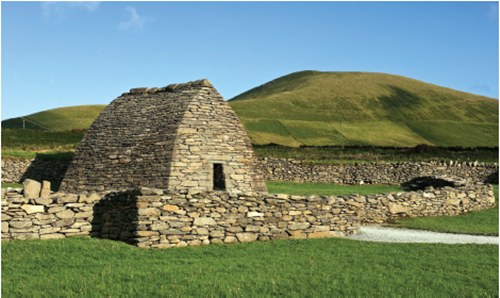
A few kilometres inland from Dunmore Head to the south and from Dún an Óir to the north, more or less in the centre of the narrow peninsula, stands the intriguing corbelled oratory of Gallarus. It is tiny. It looks for all the world like an upturned boat. It dates from around 1000 AD and is one of the best-preserved early Christian buildings in the country. Its remoteness and its diminutive size may account for the fact that what we see now is what its builder saw when he finished it.
The oratory of Gallarus is completely unmortared. The stones are laid each upon the other with such overlapping precision that it is bone dry inside and has remained so for more than a thousand years in one of the wettest locations in the northern hemisphere. This ancient corbelling technique had been used since Neolithic times, and had been employed in many of the great pre-historic burial sites. It is perhaps no surprise that such an enduring construction technique should have been deployed so successfully here three millennia after it had first been perfected on the island.
It is speculated that the principal function of Gallarus Oratory was as a way station — a place of prayer — on a pilgrimage route, possibly a seaborne route to the Camino de Santiago de Compostella. Smerwick nearby would have furnished a safe haven along this otherwise forbidding coast.
Gallarus is also redolent of the anchorite tradition in the early Irish Christian church. Because early Christian Ireland had no towns to serve as foci for dioceses, the structure of church government differed from the norm of Latin Christianity. The Irish church was monastic in structure: the great early monasteries served as proto-towns and proto-universities. But they never acquired the full sinews of urban life, nor did they develop into universities in the continental sense, as at Bologna and Paris.
Part of the monastic enterprise was a consistent search for purity of spirit, a rejection of the material and a retreat to remote places in pursuit of a spiritual life cleansed of luxury or wealth. The reform movement in the early Irish church known as the Céile Dé (the Companions of God) were especially remembered for their zealous ascetic excesses, but they were part of a tradition, not altogether at the margin of the early church, that reappeared on a regular basis. Extremes of fasting, the denial of music and an idealisation of the early desert fathers drove such rigorists towards remote and barren places like the western edge of the Dingle Peninsula. An even more celebrated and dramatic location was on the Great Skellig Rock, a vast triangular sea stack 16 km off shore, clearly visible to the south in clear weather.
These were the locations of the Irish ‘desert fathers’, echoing the anchorite ascetics of the early Eastern Church, whose huge influence in early Christianity was later eclipsed by the eminence of Rome in the west. Indeed, the Irish word ‘dysert’, which occurs in a number of place names around the island, is cognate with the Latin desertus. The excesses of the ascetics were often lampooned by more orthodox and worldly monastic writers. Not the least of these lampoons is the Navigatio Sancti Brendani Abbatis, otherwise the celebrated Voyage of St Brendan. A work of fiction, it has been read (and mis-read) as the story of an actual voyage, although some of the details are so plausible that it may be based on the lost account of a voyage that was actually accomplished.
Although it was written as a theological tract intended to satirise the ascetics, its popular fame came from its metaphor of the voyage and spawned the myth that St Brendan sailed from Brandon Creek, just below Gallarus, and discovered America in the sixth century. He may or may not have: we shall never know. In the 1970s, the adventurer Tim Severin established that it could have been done using sixth-century naval technology. It was a possibility — and it is as logical to believe that St Brendan sailed from here and reached North America centuries before the Vikings or the Basques or Columbus as it is to dismiss it all as whimsy.