![]()
Of the new bridges built in Restoration Dublin, the most important was the one on the site of the modern Capel Street bridge. For all of its history, the city’s centre of gravity gradually moved from its medieval core around Christ Church eastward towards the bay. Western overspill beyond the walls was suburban rather than urban. Capel Street bridge was originally known as Essex bridge, named for Arthur Capel, earl of Essex, who was lord lieutenant of Ireland from 1672 to 1677, Ormond having been withdrawn for a few years. In 1875 it was renamed for Henry Grattan, the eighteenth-century parliamentarian, but everyone calls it Capel Street bridge.
The new bridge was built between 1676 and 1678. The ubiquitous Sir William Robinson had a hand in its design. It created a new north–south axis from the Castle and made the development of the northern suburbs beyond a tempting prospect. This is exactly what happened in the great eighteenth-century building boom, with the earliest fashionable Georgian developments located north of the river. For the first time, the city was going to occupy both sides of the Liffey.
The bridge begged a street on the far side and it was duly developed by Sir Humphrey Jervis and tactfully named for the lord lieutenant, Jervis contenting himself with the name of a parallel side street. It led towards Drumcondra Lane, the traditional exit route from the city to the north. But it also led to lands that had originally been part of the Cistercian Abbey of St Mary, which had been suppressed at the time of the dissolution of the monasteries. These passed through various secular hands until they were bought by Luke Gardiner MP, the vice-treasurer of Ireland, in 1721.
In the forty years since Capel Street bridge was built, Ireland had finally settled the question of who constituted the ruling class. When Charles II died in 1685, he was succeeded by his brother James II, a Catholic, who unwisely attempted a Catholic restoration. He was ousted from the English throne when his wife gave birth to a healthy son in 1688 — the same year that the duke of Ormond died — in a coup d’état ever after dignified as the Glorious Revolution. He tried haplessly to restore his fortunes in Ireland, but defeats at the Boyne and Aughrim put the Protestant victory beyond any further dispute. The long age of the Ascendancy had begun.
Luke Gardiner was a banker whose personal background was obscure. He married into the aristocratic Mountjoy family. It was he who oversaw the early development of the Gardiner estate in the north-east of the city during the first half of the eighteenth century. His grandson, also Luke, Lord Mountjoy (1745–98: he was killed at the Battle of New Ross leading crown troops against the Wexford rebels), was the principal figure in the second half.
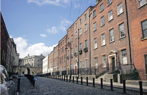
Luke Gardiner the Elder bought and developed all of what is now the area east of Capel Street as far as O’Connell Street and Parnell Square. He first developed the area at the northern end of Capel Street. Bolton Street dates from 1720 but the real triumph was Henrietta Street, dating from a few years later (see previous photograph). Here, on lands originally belonging to the Cistercians, Gardiner built enormous town houses, including one for himself at number 10, vastly more spacious than anything else put up in the Georgian era. The hallways alone are huge, bigger than the total floor area of many modern suburban houses. One of the first residents was Hugh Boulter, archbishop of Armagh, a key political and social figure of the day. Fashion — not least clerical fashion — followed him. Before long, Henrietta Street was known colloquially as Primate’s Hill. It helped to establish the north-east suburbs of the city as the centre of early fashionable life. The drift of the beau monde to the south side did not start in earnest until the second half of the century.
This Luke Gardiner was also responsible for the development of Gardiner’s Mall, later to mutate into Sackville Street and later again to O’Connell Street. When Gardiner acquired it in 1714, it was known as Drogheda Street (or Lane). This was named for Henry Moore, earl of Drogheda, who is commemorated in Henry Street, Moore Street, Earl Street and Of Lane, all of which have survived. Gardiner widened it by knocking down most of the existing properties — it was an unsentimental business, not encumbered by modern concepts of planning and conservation — and creating a central mall that ran from what is now Parnell Street to the modern Spire. This central area was named Gardiner’s Mall, the two parallel sides Sackville Street — named for Lionel Sackville, Duke of Dorset, lord lieutenant in the 1730s. The unwidened lower end retained the name Drogheda Street (thus giving the earl a full house, for the moment at least) until the extension of Sackville Street to the river in the 1780s. Meanwhile the lord lieutenant was further immortalised in Dorset Street, which was developed (but not by Gardiner) along the line of the old Drumcondra Lane.
Shortly before his death, Luke Gardiner the Elder began the development of Rutland Square (now Parnell Square) which in time became a major centre of fashion, never more so than when Lord Charlemont built his town house in Portland stone — to distinguish it from the mere brick of the mansions adjacent — in the 1760s. It is now the Hugh Lane Gallery.
At the corner of Rutland Square nearest the top of Sackville Street, Bartholomew Mosse acquired four acres of land in 1748. Mosse was the proprietor of the Lying-In Hospital, the first dedicated maternity hospital in the world, which he had founded in George’s Lane (now South Great George’s Street) three years earlier. On this site he planned to build a larger maternity hospital and he engaged Richard Cassels, a Huguenot from Hesse in Germany who had inherited the practice of Edward Lovett Pearce and established himself as the leading Dublin architect of the 1730s and 1740s. Cassels did not live to see his design realised but it was completed by his pupil John Ensor. The Roto — a Dublin landmark ever since — opened on 8 December 1757.
The legacy of three generations of the Gardiner family was absolutely transformative. It was not just that they developed Dublin to the east of the medieval core: they started the process whereby the mental centre of the city moved east with them. The broad axis of Sackville Street, leading to the bridge and later to connect with the new D’Olier and Westmoreland Streets, combined with the earl of Leinster’s decision in 1745 to build his town house south of the river — here fashion followed him, never to return north — created the basic geography of the modern city.
In a sense, the Gardiners were too successful. In developing the north side, they must have thought that its rising ground would have been ideal for their wealthy clientele, for wealth has always coveted an eminence. Instead, in yet another demonstration of the law of unintended consequences, they opened up an avenue to the south. The area around Leinster House, now the most fashionable part of the city, was gradually being developed in the early eighteenth century but not at all as intensively as the Gardiner estate on the north side. The earl of Leinster’s move was decisive, although there were problems in the area that did not afflict the north side. Not the least of these was marshy ground and the danger of flooding from the river. The low-lying south side suffered severe flooding in 1735, 1746, 1761 and 1764. In 1792, a breach in the retaining wall of Sir John Rogerson’s Quay allowed a party of sportsmen to sail a boat on the flood waters that delivered them to the back garden of a house in Merrion Square! No matter: fashion had moved south and, floods or no floods, there it stayed.