Plan your walk |
|
 |
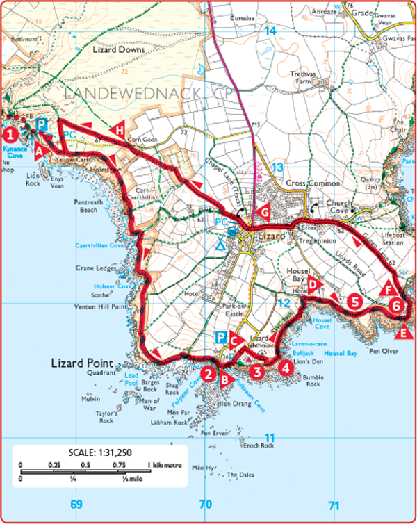
DISTANCE: 5 miles (8km) TIME: 3 hours START/END: SW689132 Park at Kynance Cove. If visiting Kynance Cove first, follow the signpost to walk down to the cove. TERRAIN: Moderate MAPS: |
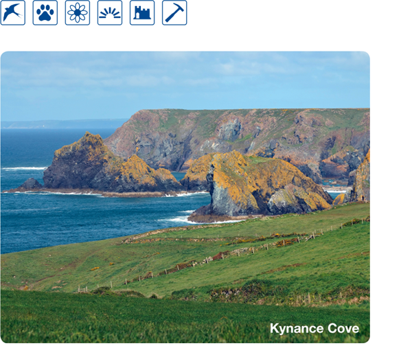
 An understandably very popular cove, the beauty of Kynance has been attracting visitors for generations. There are evocative names for features such as Lady’s Bathing Pool and the Devil’s Letter Box. Geologically the cliffs and stacks of colourful serpentine rock are of considerable interest, but the area is ecologically important too, with several plants found here that are not found anywhere else in Britain.
 Leave the car park to join the cliff path signposted to Lizard Point. Follow the path above Pentreath Beach and continue along the well-defined path towards Polpeor Cove.
 Polpeor Cove is the site of a disused Victorian lifeboat station. In 1907 this was the scene of the biggest rescue in the RNLI’s history when the lifeboat saved 167 lives after the White Star liner SS Suevic hit a reef in dense fog. In 1961 the lifeboat station moved to Kilkobban Cove, 1½ miles (2.4km) away.
 Cross the road and continue on the coast path. Turn left at the signpost for the Lizard Lighthouse.

 The Lizard Lighthouse has guided ships on the English Channel, one of the busiest shipping lanes in the world, along a particularly hazardous coast for over 250 years. The beam can be seen for 26 miles (42km). The renovated engine room now houses the Lighthouse Heritage Centre with exhibitions, interactive displays and tours of the lighthouse tower.
 Take the permissive path that goes around the lighthouse boundary wall, keeping the wall on your right before rejoining the coast path.
 Lion’s Den is an impressive, unfenced 40ft (12m) hole in the cliff, created when a sea cave collapsed one night in 1847.
 Pass above Housel Bay, below the Housel Bay Hotel and continue round the path of Pen Olver headland. Look back for stunning views of the lighthouse behind you. Pass the Lizard Wireless Station on your left.
 Two unremarkable looking black wooden huts on the headland of Pen Olver comprise the oldest surviving purpose-built wireless communications station in the world. Guglielmo Marconi used them for pioneering experiments and in 1901 set a new wireless distance record with a message that had travelled 186 miles from the Isle of Wight. The buildings have been restored by the National Trust and can be visited, although opening times are limited.
 Go round Bass Point Old Signal Station.
 The unmistakable castellated building of the former Lloyds Signal Station was built in 1872. Over 1000 ships a month used the station in 1878, sailing in close to the point to register their names and collect messages. Although owned by the National Trust it is now a private home.
 Leave the coast path by continuing on the track ahead, through the gate for Churchtown Farm. Pass the farm buildings and turn left onto the road. Turn left again at the next junction and pass the school on your right.
 In Lizard village go straight across the road, signposted ‘coastal footpath’, then straight across the next road, signposted ‘Kynance Cove’. Bear right onto the signposted track to follow the footpath along the top of a double hedge bank. Bear right again at the footpath junction in the thicket to follow the path slightly uphill. Continue along the well-defined path across fields to reach a stile at the bend of a road.
 Walk straight ahead along the road, signposted to the car park, turning right onto the footpath that runs parallel to the road. As the path joins the track at the edge of the car park either turn left to the car park entrance or right to enter the other end of the car park and the path down to Kynance Cove.