
Plan your walk |
|
 |
DISTANCE: 4½ miles (7.25km) TIME: 2½ hours START/END: SW850672 Mawgan Porth car park TERRAIN: Moderate MAPS: |
 Park at the beach car park in the small resort of Mawgan Porth. Turn right out of the car park onto the road, then turn right at the next road. The bus stop has no sign but is opposite the putting green, between the village hall and the road junction on the opposite side of the road from the bus stop for Newquay.
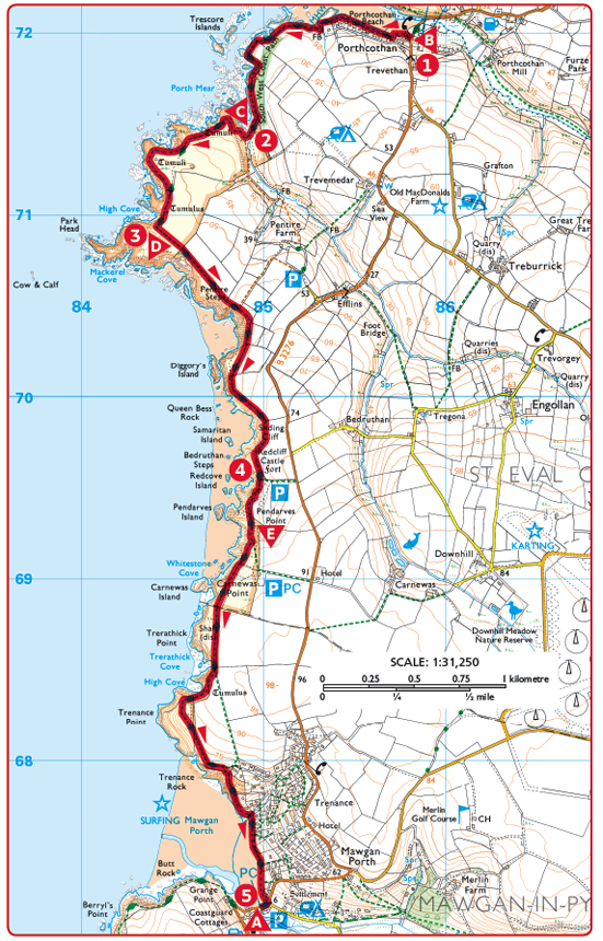
 Get off the bus at Porthcothan. From the bus stop, next to the telephone box, take the sandy path to the beach. Branch left in the dunes to pick up the coast path. The path continues along and above the south shore of the beach, climbing gradually before descending to Porth Mear.
 The long, narrow bay of Porthcothan is sheltered by a small dune system. There is a large expanse of sand at low tide, making it a popular family beach.
 At Porth Mear there is a good example of a ‘sanding lane’, evidence of the times when farmers collected lime-rich sand from the beach to transport back to spread on acidic fields.
 At Porth Mear cross the stream over a footbridge and continue to Park Head.
 The small mounds on this grassy headland are remnants of an Iron Age cliff-top castle, one of many along the headlands of north Cornwall.

 After descending Park Head you pass Pentire Steps where a zig-zag path used to lead down to the beach until it was destroyed by landslides. Approaching Bedruthan are the remnants of Redcliffe Castle, another Iron Age promontory fort. A short distance further along the coastal path and you will come to Bedruthan Steps.
 Bedruthan Steps are rock islands of volcanic origin left isolated through erosion. The legend is that the stacks are the stepping stones of the giant Bedruthan, although this may well be a 19th century invention. The site became popular in Victorian times when visitors came in their carriages, and it is still one of the most visited sites in the area. The access steps down to the beach have suffered from erosion over the years but are now secure using netting to hold back rockfall. However, they are closed through the winter and at other times of risk. At the National Trust Carnewas site on the cliff top there is a car park, shop, toilets and refreshments in season.
This part of the coast was particularly hazardous for shipping before the Trevose Lighthouse was buiIt in 1847. The brig Samaritan, with a cargo of cotton and silks was wrecked off the Steps in 1846 with only two survivors. For months afterwards, the locals were decked out in finery looted from the wreck. They heartlessly named it The Good Samaritan and one of the Steps is known as Samaritan Island.
 Continuing from Bedruthan, the path runs through gorse and heather on the cliff-top to return down to the beach at Mawgan Porth.
 The sheltered resort of Mawgan Porth has a good sandy beach and has become a popular centre for surfing. As with Porthcothan the extent of sand at low tide and the level access to the beach mean that this is also a favourite place for families in summer. Cafés and other facilities are available.