
- EPIC BIKE RIDES OF THE WORLD -

CUBA’S SOUTHERN ROLLERCOASTER
Pounded by surf, overshadowed by mountains and deeply imbued with revolutionary history, this lonely ride along Cuba’s Caribbean coast pulsates with natural and historical drama.
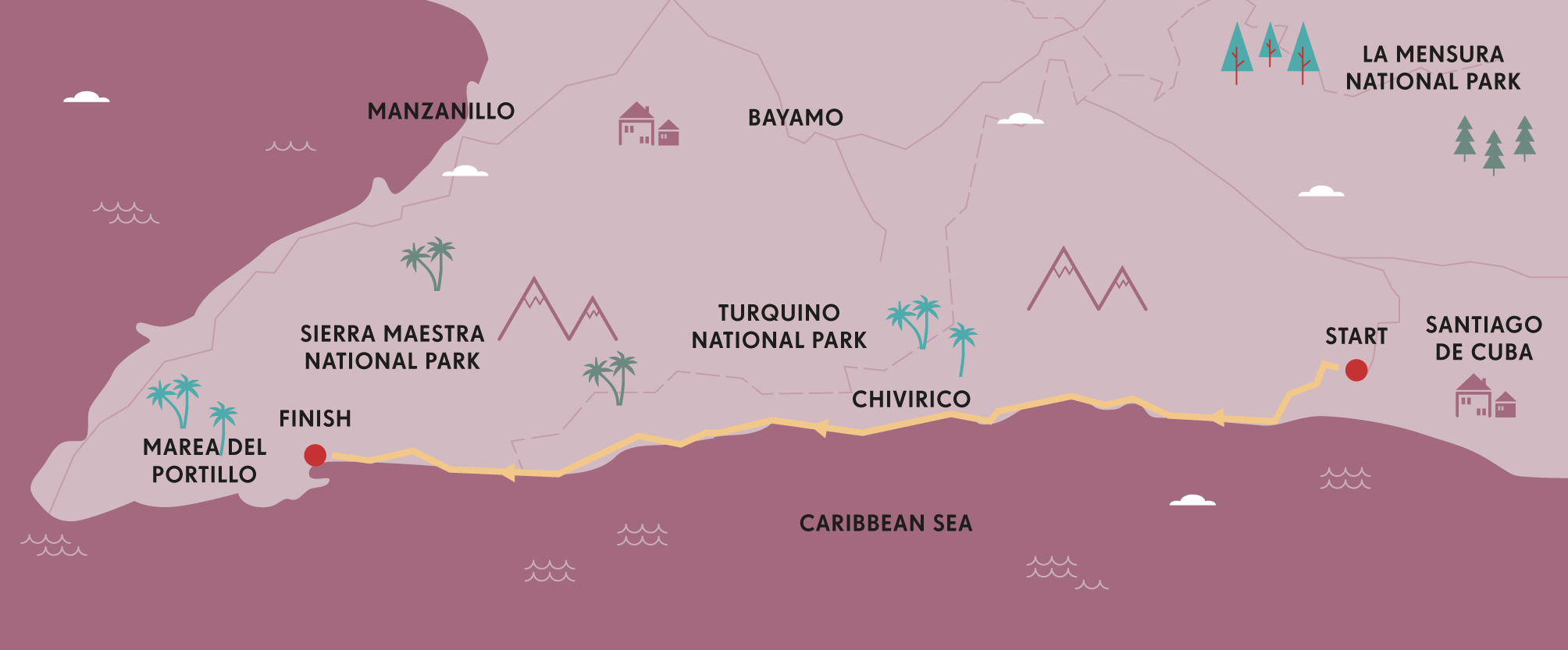
Cuba is full of dichotomies and its roads are no exception. Take Carretera N20 for instance, the 106 miles (170km) of potholed asphalt that runs along the south coast between Santiago de Cuba and the rustic village of Marea del Portillo, a spectacularly battered thoroughfare that could quite conceivably be described as the nation’s best and worst highway. Shielded by purple-hued mountains that tumble down to meet the iridescent Caribbean, it scores ten-out-of-ten for craggy magnificence. But, lashed by hurricanes and beset by a severe lack of maintenance, it can be purgatory for aspiring drivers. Not surprisingly, few cars attempt it, leaving the road the preserve of goats, vaqueros (cowboys) and the odd two-wheeled adventurer on a bicycle.
During nearly 20 years of travel in Cuba, I have traversed this epic highway in numerous ways, most notoriously on a protracted hitchhiking trip involving at least a dozen changes of vehicle, from a terminally ill Fiat Uno to a truck where the only other passenger was a dead pig. But my preference, if time and weather allows, is to tackle it on a bicycle. As visceral experiences go, this is Cuba as its most candid. The salty air, hidden coves, and erstwhile revolutionary history conspire to form a proverbial Columbian voyage of discovery that becomes more magical the further you pedal.
Fidel Castro and his band of bearded guerrillas lived as fugitives in these mountains for over two years in the late 1950s and the sense of eerie isolation prevails. Indeed, so deserted is the road that, in the handful of bucolic hamlets en route, farmers use it to air-dry their coffee beans, kids hijack it for baseball games, and cows parade boldly down the middle of the sun-bleached thoroughfare as if the motor car had never been invented.
Base camp for anyone attempting the ride is Santiago de Cuba, the nation’s second largest city and, in many respects, its cultural capital. Heading west from here, the journey is best split into three stages. While route-finding is easy, the ups and downs of the highway as it curls around numerous headlands present a significant physical challenge. Be prepared. Roadside facilities range from scant to non-existent.

© Jeremy Woodhouse | Getty Images
a rural church in Santiago de Cuba
The first time I ventured out on a borrowed bike, I carried inadequate provisions and ended up knocking on the doors of isolated rural homesteads to ‘beg’ for water. Sure, I met some very obliging campesinos (country dwellers) offering liquid refreshment (including rum!), but the head-lightening effects of the dehydration probably weren’t worth it. To avoid a similar fate, arm yourself with a robust bike and carry plenty of food and water.
The first recently repaired section from Santiago to the small town of Chivirico sees a modest trickle of traffic. Look out for growling camiones particulares, the noisy trucks that act as public transport in these parts. Around Chivirico you might spy another unique Cuban-ism, the amarillos, government-sponsored transit officials named for their mustard yellow uniforms; their job is to stand by the side of the road and flag down passing vehicles for hitchhikers.
“This remote region has remained utterly unspoiled, a glorious ribbon of driftwood-littered beaches”
Chivirico also has one of the route’s strangest epiphanies, the Brisas Sierra Mar, an unpretentious all-inclusive hotel that springs seemingly out of nowhere 40 miles (65km) west of Santiago. Treat yourself: there is precious little accommodation for the next 62 miles (100km).

CLIMBING PICO TURQUINO
Cuba’s highest mountain, Pico Turquino (1974m), is regularly climbed from Hwy 20, starting from a trailhead at Las Cuevas just west of El Uvero. It’s a steep and gruelling 10-hour grunt to the top and back, but no specific mountaineering skills are required. The ascent must be made with a guide, but can be split over two days with a night spent in a basic mountain shelter.
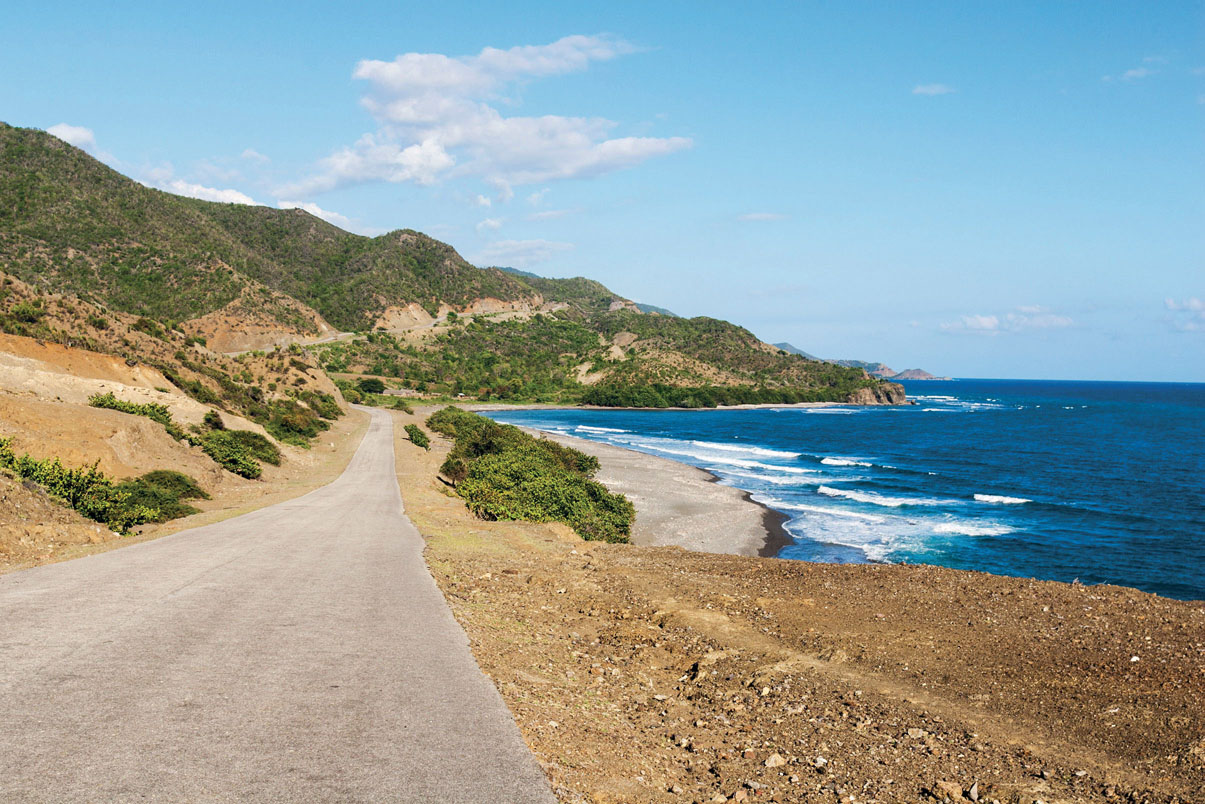
West of Chivirico, traffic dwindles to virtually nothing, while the eroded state of the road can make the going ponderous, even for cyclists. Fortunately, the magnificence of the scenery makes slow travel highly desirable.
This remote southeastern region has remained utterly unspoiled, a glorious ribbon of driftwood-littered beaches and crashing surf backed by Cuba’s two highest peaks, Turquino (1974m) and Bayamesa (1602m). Such settlements that exist are tiny and etched in revolutionary folklore. El Uvero at the 60 mile (97km) point has a monument guarded by two rows of royal palms commemorating a battle audaciously won by Castro’s rebels in 1957. Further west, La Plata, the site of another successful guerrilla attack, maintains a tiny museum. Just off the coast, vestiges of an earlier war lie underwater in the wreck of Cristóbal Colón, a Spanish destroyer sunk in the 1898 Spanish-American war. Today it’s a chillingly atmospheric dive site.
By now the steep headlands and tropical temperatures will have turned your legs the consistency of overcooked spaghetti. La Mula, around 6 miles (10km) west of El Uvero, is a rustic campismo with basic bungalows where you can recuperate just metres from the ocean.
On day three as the road crosses from Santiago de Cuba province into Granma, I like to pull over at one of the wild, Robinson Crusoe-like beaches and admire the increasingly dry terrain. Dwarf foliage including cacti is common, a result of the rain shadow effect of the Sierra Maestra. Aside from sporadic ramshackle villages, civilisation is confined to occasional bohios (thatched huts) dotting the mountain foothills. Sometimes, you’ll inexplicably spy a lone sombrero-wearing local pacing alongside the roadside, miles from anywhere, clutching a machete.
The tiny fishing village of Marea del Portillo is equipped with two low-key resorts that guard a glowering dark-sand beach framed by broccoli-green peaks. Don’t be deceived by the home-comforts. You’ve just arrived in one of the most cut-off corners of Cuba. To the north, crenelated mountain ridges shrug off clusters of bruised clouds. To the west sits Desembarco del Granma National Park, famed for its ecologically rich marine terraces. For me, this is paradise personified, a chance to resuscitate my bike-legs, carb-load at the hotel buffet and go off into the wilderness to explore some more. BS

TOOLKIT
Start // Santiago de Cuba
End // Marea del Portillo
Distance // 106 miles (170km) along a rutted but easy-to-follow road.
Getting there // The nearest airport is Aeropuerto Antonio Maceo, 4 miles (6km) south of Santiago de Cuba. From here there are daily flights to Havana, and direct flights to Canada.
Bike hire // This is rare and unreliable in Cuba. Most serious cyclists bring their own bikes with them.
Where to stay // Club Amigo Marea del Portillo (+53 23-59-70-08; www.hotelescubanacan.com); Campismo La Mula (+53 22-32-62-62; www.campismopopular.cu); Brisas Sierra Mar (+53 22-32-91-10; www.hotelescubanacan.com)
When to ride // The best time is mid-November to late-March. However, the road is prone to flooding and closures. Check ahead in Santiago.
© Pierre Logwin | Alamy
a coast road in the Sierra Maestra
- EPIC BIKE RIDES OF THE WORLD -
MORE LIKE THIS
CUBAN RIDES
LA FAROLA
Hailed as one of the seven modern engineering marvels of Cuba, La Farola (the lighthouse road) links the beach hamlet of Cajobabo on the arid Caribbean coast with the nation’s beguiling oldest city, Baracoa. Measuring 34 miles (55km) in length, the road traverses the steep-sided Sierra del Puril, snaking its way precipitously through a landscape of granite cliffs and pine-scented cloud forest before falling, with eerie suddenness, upon the lush tropical paradise of the Atlantic coastline. For cyclists, it offers a classic Tour de France-style challenge with tough climbs, invigorating descents and relatively smooth roads. La Farola starts 124 miles (200km) east of Santiago de Cuba and is thus best incorporated into a wider Cuban cycling excursion. You could also charter a taxi to drop you off at the start point.
Start // Cajobabo
End // Baracoa
Distance // 34 miles (55km)
GUADALAVACA TO BANES
Talk to savvy repeat visitors in Guadalavaca’s popular resort strip and you’ll discover that one of the region’s most epiphanic activities is to procure a bicycle and pedal it through undulating rural terrain to the fiercely traditional town of Banes 21 miles (33km) to the east. This beautifully bucolic ride transports you from the resort-heavy north coast to a gritty slice of the real Cuba in a matter of hours along a road where you’re more likely to encounter a horse and cart than a traffic jam. Some of the resorts lend out bikes but pedalling these basic machines can be hard work; in-the-know visitors often fly in with their own bikes (Holguín’s Frank País international airport receives direct flights from the UK, Canada and Italy).
Start // Guadalavaca
End // Banes
Distance // 21 miles (33km)
VALLE DE VIÑALES
Viñales is a small farming community that does a lucrative side-business in tourism. It sits nestled among craggy mogotes (steep, haystack-shaped hills) in Cuba’s primary tobacco-growing region. With about as much traffic on its roads as 1940s Britain, the region – which is protected as both a Unesco World Heritage site and National Park – is ideal for cycling. Various loops can be plotted around the valley’s multifarious sights, which include caves, tobacco plantations, climbing routes and snippets of rural Cuban life. Riders can hire from the Bike Rental Point in Viñales’ main plaza. Or your casa particular (private homestay, of which there are dozens in the village) may have bicycles available to rent.
Getting there // Viñales is easily reached from Havana by bus
Distance // Whatever you feel like
© Mark Read
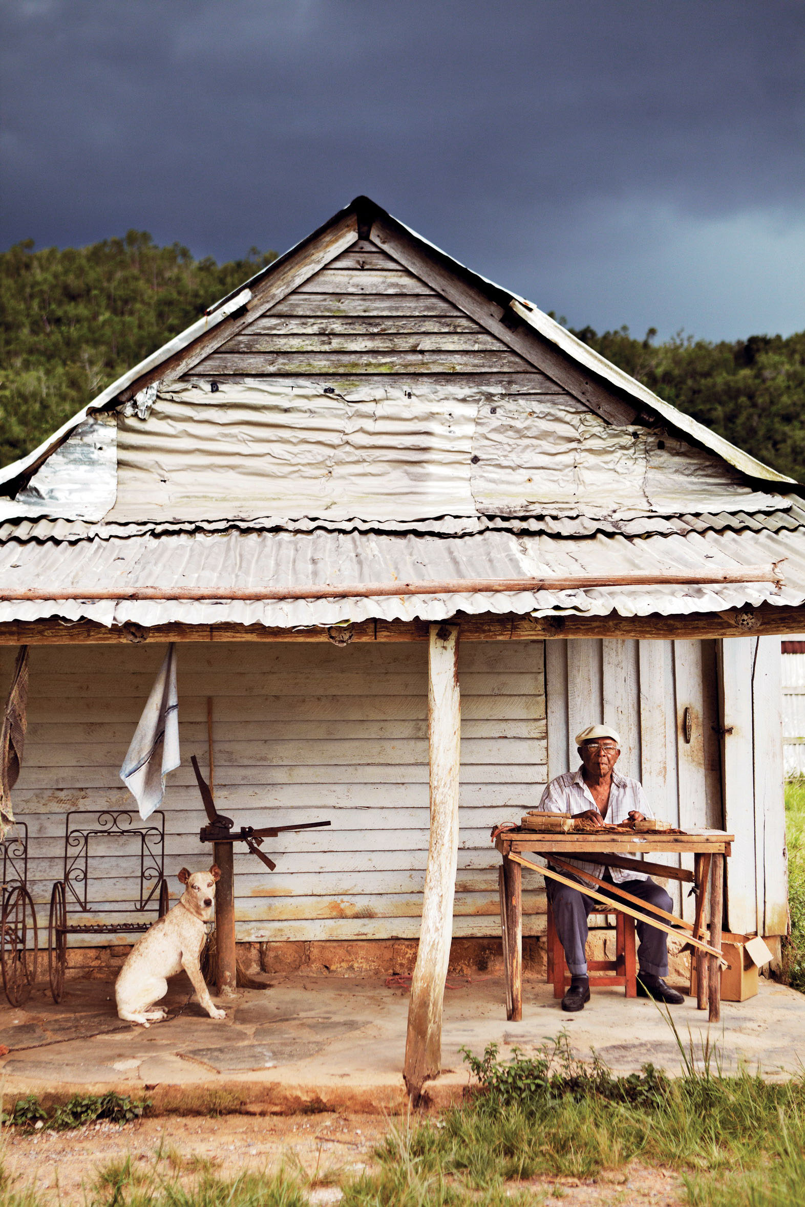
a Cuban cigar roller in the Valle de Viñales
- EPIC BIKE RIDES OF THE WORLD -
TO THE TIP OF PATAGONIA
Cyclists rub shoulders with gauchos and guanacos in southern Argentina, braving howling wind to reach the tip of the South American continent.
Out on the bolt-straight roads of the Argentinian pampa (vast plains) my handlebars stay true, but my mind wanders. The open expanse of Southern Patagonia is a pensive place, a vast and empty land that stirs memories and emotion, like a calling to fill its void.
As my legs spin, I hum along to the buzz of knobbly tyres on smooth asphalt. I listen to the snap of my open shirt, which flaps behind me like a cape. I try and clear my head. But like any meditation, I become stuck on certain thoughts, clanking around like coins in a washing machine. Before long, an ostrich-like rhea waddles out of the camouflage of the plains. I smile, my spirits lifted. Then, a guanaco, the camelid native to these parts, breaks rank and jumps daintily over the endless fence line I’ve been following. It makes a chuckling sound as I pass, as if remarking on the ridiculousness of my toils.
It’s a sentiment that seems to be echoed by others. Once, I see the blur of a passenger photographing me from a minivan that hurtles past. What must they be thinking? I guess I must look a little crazy, bearded and unkempt, out here in the emptiness. Later, a couple flag me down to quiz me about my bike. We talk a while by the roadside. I’ve noticed a distinct soulfulness in Argentinians, perhaps intensified by the thought-stirring sparseness of their land. ‘Que lindo este viaje,’ the man says, gesturing to his heart, and shaking my hand warmly. ‘What a beautiful journey.’
A beautiful journey indeed, and one that captures Patagonia’s contemplative character, its windswept isolation and its spectacular vistas. Indeed, the ride down from El Chaltén showcases one its finest moments; the granite silhouette of Monte Fitz Roy is the stuff of picture postcards and mountaineering legends.
© Cass Gilbert
heading into the Patagonian hills
I pedal on. As asphalt peters out, I plough my way through deep, corrugated ripio (gravel), gliding from one side to the other in search of the truest line. In this light, it’s hard to even tell what time of day it is. It could be just before sunset, but in fact it’s early afternoon. Scale plays games on the pampa, and distance takes on a different quality; perhaps a more mysterious form of measurement is appropriate, like leagues. Only roadside shrines mark the passing of time, and drainage culverts, into which cyclists sometimes burrow to escape the howling winds.
And those winds! They’re incessant. Thankfully, my southerly trajectory means they’re in my favour much of the time. But when they’re not, it’s like slamming against a steel wall. A particular tactic is thus required: strategic hops from one wind-free or rain-sheltered enclave to another. Most are abandoned buildings, skeletal husks that resonate former lives. Like hallowed secrets, the exact locations of these sanctuaries are swapped around a carton of wine at a campsite, or scrawled onto a crumpled map out on the road.
Among the most popular is the so-called Pink Hotel on Ruta 40, the legendary road that spans the entire length of this country. An abandoned complex set on a solitary stretch of pampa, the Pink Hotel has long shielded a migration of riders from the howling, tent-crushing wind that gathers with gusto each afternoon. On the night I pass through, it’s a surprisingly social premises. I’m one of five riders heading south, joined by a French-Canadian couple braving the elements north. We roll out our mats on the hotel’s parquet floor and sign the guestbook: the canvas of a graffitied wall, onto which cyclists scrawl their names and a precis of their journeys.
PENGUIN COLONIES
No visit to Patagonia is complete without an encounter with its most characterful residents. Of the two penguin colonies en route, one involves a ferry ride to Isla Magdalena, home to 60,000 pairs of Magellanic penguins. Like drunkards dressed up for a ball, they stagger around in the high winds. The other is at Parque Pingüino Rey in Bahia Inútil, where cyclists can camp near a group of majestic King Penguins that stand up to 1m tall.
Other such places of calm come and go. At a lonely outpost near Tapi Aike, Fabien the police officer ushers me in, as he has done to so many cyclists before me. He feeds me a hearty dinner, and together we watch dubbed movies late into the night. And there’s Panadería La Union, about which I hear stories months before I actually arrive. Its location is triple-ringed excitedly on my dog-eared map, and a note scrawled to the side: ‘Bakery. Delicious empanadas and cakes. Hosts cyclists for free.’
Breaking the monosyllabic mood of Southern Patagonia, there are also moments of startling eloquence. Sometimes, it’s as simple as a lenticular cloud, or a team of muscular horses watching me ride by. At other times, it’s raw geology. In El Calafate, I head out to Perito Moreno Glacier. Spanning 2.5 miles (4km) in width, the sight itself is as impressive as the sound it emits: an incessant soundtrack of gurgles and murmurs, of deep, resonant rumbles and thunderous crunches.
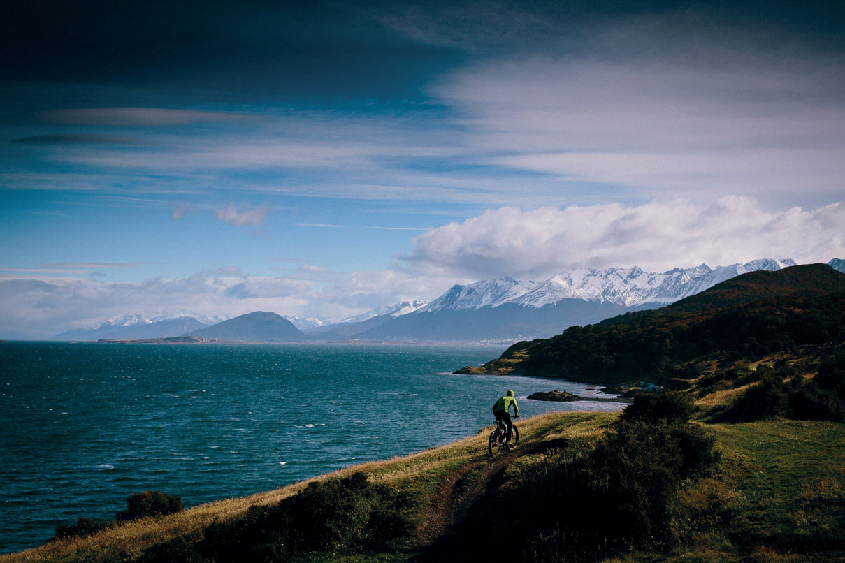
I ride on, away from Ruta 40, forging my way closer to the coastline, until finally I cross the Strait of Magellan to Tierra del Fuego, the Chilean and Argentinian archipelago that lies off the southernmost tip of the South American continent. It’s named after the myriad of fires once kept by the indigenous Yámana – a hardy folk who walked barefoot through snow. By now, I’m a member of my own impromptu cycling collective, pilgrims drawn from around the globe, pedalling by day and sharing stories by night.
For many, riding to the very tip of the South American continent is the end of long, arduous and undoubtedly beautiful journey; adventures that have unfolded since Colombia, Mexico or even Alaska. And now here we are. Together, we cycle through the gates of Ushuaia. Connected by a rush of similar emotions, we high-five. We hug. We look round in slight disbelief. Yes, we’ve arrived. Ahead, the road has finally run out. CG
“Together we cycle through the gates of Ushuaia. Connected by a rush of similar emotions, we high-five”
TOOLKIT
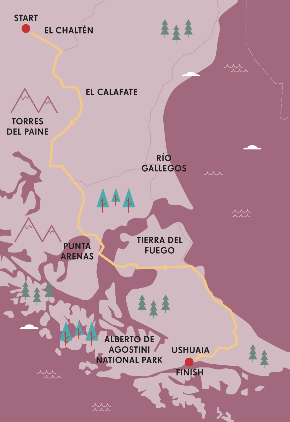
Start // El Chaltén
End // Ushuaia
Distance // 714.5 miles (1150km)
Getting there // Fly or bus into El Calafate, and out of Ushuaia.
When to ride // The best time to visit the area is during Patagonian summer – from November to March.
How to ride // Head north to south, or face a soul destroying headwind much of the way.
Where to stay // Bring a stout tent, and keep your eyes peeled for abandoned houses!
What to take // Weather can be notoriously mixed; pack plenty of layers and reliable waterproofs.
Detours // Allow time to day hike in Argentina’s world class Los Glaciares National Park, explore Torres del Paine in Chile, or connect this route with the 621-mile (1000km) Carretera Austral.

© Cass Gilbert
riding with horses on the Patagonian pampa
- EPIC BIKE RIDES OF THE WORLD -
MORE LIKE THIS
REMOTE RIDES
SALAR DE UYUNI, BOLIVIA
Cycling atop the salt crust of Bolivia’s Salar de Uyuni – and the more petite but perfectly formed Salar de Coipasa – is an undisputed highlight of many a South America journey. It’s a high-altitude ride that takes five or six days, segmented by an opportunity to resupply with water and food at the midway settlement of Llica. As the largest salt flat in the world, cycling here provides an other-worldly experience. There’s nothing quite like pitching your tent on a bleached white canvas, seasoning your dinner with the salty ground on which you’re sitting, and awakening in the morning to a glow of ethereal, lavender light. This journey can only be undertaken in Bolivia’s winter, as during summer the salt lakes are inundated by seasonal rain.
Start // Uyuni
End // Sabaya
Distance // 186 miles (300km)
CANNING STOCK ROUTE, AUSTRALIA
Riding Western Australia’s Canning Stock Route is a monumental challenge. In fact, it’s only been successfully completed by a handful of riders. Given the extended sections of soft sand, dunes and corrugation that typify such a vast, remote and unforgiving desert, this is a route that can only be undertaken on a fat bike, sporting a colossal tyre size of at least 4in in width. You’ll also need to carry enough food for more than 30 days, and water for four- to five- day stretches at a time. Despite the 51 old wells that punctuate the route, only a handful can be relied upon. But for anyone prepared to tackle this physical and logistical feat, the reward is complete, unmatched desert solitude.
Start // Hall Creek
End // Wiluna
Distance // 1243 miles (2000km)
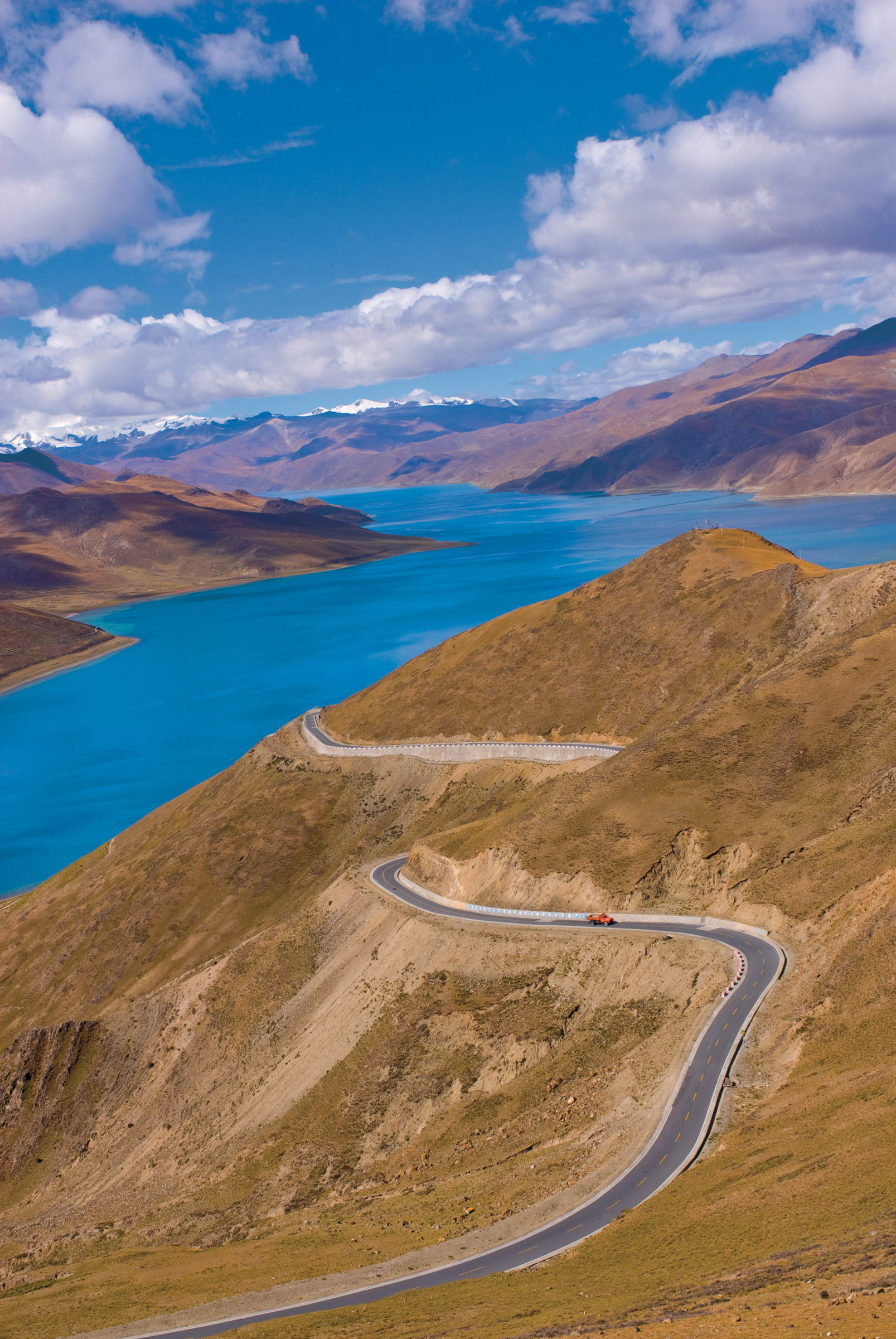
FRIENDSHIP HWY, TIBET–NEPAL
Bookended by the cities of Lhasa and Kathmandu, the Friendship Hwy crosses the Tibetan plateaux via a series of high elevation passes, the highest of which reaches 5251m. Given that much of the pedalling takes place at over 4000m – across the Roof of the World, as it’s often called – pre-ride acclimatisation is vital, particularly if flying into Lhasa. The journey itself takes 3 weeks, including a detour to Everest Base camp, promising stunning views of the planet’s highest peak. Elsewhere, the Himalayan showcase continues, with the likes of Cho Oyu (8241m) and Shishapangma (8042m) prodding into the atmosphere. Leaving the Land of Snows is like entering another world; Nepal’s green backdrop provides a sudden and stark change from Tibet’s vast and windswept plateau. Given the political sensitivity of the area, independent travel can be limited. Currently, the Friendship Hwy can only be ridden as part of an organised group.
Start // Lhasa, Tibet
End // Kathmandu, Nepal
Distance // 594 miles (956km)
© Nancy Brown | Getty Images
Lake Namtso on the Friendship Hwy, north of Lhasa
- EPIC BIKE RIDES OF THE WORLD -

THE NATCHEZ TRACE PARKWAY
The Natchez Trace coasts through three Southern states of America, with thousands of years of history beneath your wheels and the sounds of Elvis in your ears.

At the northern terminus of the Natchez Trace Parkway, a milepost sticks up like a thumb on the side of the road. For many bikers, the brown sign represents the final lap, an exclamation point punctuating a two-wheeled odyssey that started two states away in Mississippi. For southbound cyclers like me, however, the marker is just the beginning. ‘Mile one,’ I exclaim ceremoniously, translating the sign’s three digits.
Over 10 days, I will pedal 444 miles (714.5km) from Nashville to Natchez, with a small wedge of Alabama in between. During my journey on the National Park Service road, I will roll through thousands of years of history, and not necessarily in order. I will follow in the footsteps of giant sloths and Chickasaw tribes, Kaintucks (Ohio River farmers and boaters) and Elvis, and Civil War soldiers and Oprah.
During hours-long rides, I will share the two-lane paved road with a handful of cars and motorcycles (the maximum speed limit of 50 miles/80km per hour deters rushed drivers), kindred spirits in padded shorts and helmets (peak season is autumn) and countless critters, including armadillos both dead and alive. And in and out of my saddle, I will experience Southern traditions that touch all aspects of life, from grits to music to football.
The New Trace, a straight arrow that dates from 1936 and roughly parallels the original foot trail, is not as arduous as the Old Trace, a meandering dirt path studded with rocks and roots. Nor is it as perilous: the poisonous snakes, tribal attacks and bandits appear only in yellowed accounts.

© Jeff Crass | 500px
Nashville, capital city of country music
But the communities are still dispersed like distant beacons. I have to watch the clock and my pace if I want to arrive at my lodging before nightfall – or, in the case of Leiper’s Fork, to catch open mic night at Puckett’s Grocery & Restaurant.
The 19th-century village, about 15 miles (24km) from the Trace entrance in Tennessee, is a darling among Nashville stars (the Judds, Carrie Underwood) and troubadour musicians seeking an impromptu jam (Aerosmith bandmates). When I enter Puckett’s, two young guitarists are electrifying the crowd with a Jimi Hendrix cover. I’m introduced to the unofficial mayor of Leiper’s Fork, a towering grey-haired man in a baseball cap named Goose.
‘This is one of the prettiest parts of the country, especially on the Trace,’ Goose yells into my ear, mentioning the maple and oak trees lining the parkway. He then directs my gaze to the stage, pointing to the keyboardist, who plays with Neil Sedaka, and the guitarist, who tours with Ted Nugent. He widens his sweep to point out Naomi Judd’s husband and a CIA agent who I am supposed to forget as soon as I see her.
THE HOME OF ELVIS
The birthplace of Elvis is the B-side of Graceland. In Tupelo you can visit the 15-acre park complex that houses both his humble childhood home and a museum of memorabilia. There’s also the legendary Tupelo Hardware Company, which still sells tools and instruments. Inside the store, stand on a black X that marks the spot where the future rock n’ roll star picked out his first guitar.
I don’t have much time to ease into the Trace. The longest distance – 72 miles (119km) – falls on the second day. The Tennessee portion is the hilliest, slowing my speed and stretching my energy reserves. Informational placards and historic sites further impede my progress. At the Meriwether Lewis National Monument, I meet a New Orleans-bound skateboarder tending to his injuries after a crash and the Nashville couple who have been cheering me on with fist-pumps through their sunroof. We discuss the rumour that the famed explorer died of syphilis. But the National Park refuses to gossip. An interpretive sign by a stone memorial elusively explains that his life ‘came tragically and mysteriously to a close.’
“At FAME Recording Studios, an employee invites me inside Studio A, where Aretha Franklin cut two hits”
In Florence, at Milepost 338, a group of motorcyclists huddle around Tom Hendrix to hear the emotional tale of his great-great-grandmother. As a Yuchi girl, he explains, she was forced to leave her tribal land in Alabama for Indian Territory in present-day Oklahoma. She was restless, however, and reversed course. She spent five years searching for her way back home.
In the 1980s, Tom started to collect millions of pounds of rocks and build the 1½-mile/2.5km-long Te-lah-nay’s Wall to honour her life and spirit. The eastern portion runs in a direct line and represents the Trail of Tears; the western section sprawls in many directions, symbolising her meandering return route.
At Muscle Shoals, about 20 miles (32km) off the Trace in Alabama, is where some of the biggest names up and down the radio dial have recorded, such as Otis Redding, Etta James, Paul Simon, Bob Dylan, the Rolling Stones and Band of Horses. At Muscle Shoals Sound Studio, a museum guide encourages me to shake a pair of maracas in the booth where Mick Jagger and Keith Richards belted out three songs on ‘Sticky Fingers’. A German tourist ducks into a sacred but still-operating space: the bathroom where Richards wrote ‘Wild Horses’.
At FAME Recording Studios, an employee invites me inside Studio A, where Aretha Franklin cut two hits and Alicia Keys played the piano for the 2013 documentary film, Muscle Shoals. In Studio B, he tells me that Duane Allman once slept and performed here. For the next 60-odd miles (97km) to Tupelo, I have Southern rock stuck in my head.
For 361 miles (581km), I have biked solo. But one morning, I unexpectedly become a duo. A French-Canadian in striped long underwear sidles up next to me and strikes up a conversation that endures for more than 80 miles (129km). We become a trio when a former turkey farmer from North Carolina joins us.
We count down the final distance together, with the French-Canadian throwing up his arm at significant intervals. At the three-mile (5km) mark, I start to feel a mix of elation and deflation. At the last mile (1.6km) of Natchez, I pedal slower, savouring it as much as I did the first in Nashville. AS
TOOLKIT
Start // Nashville, Tennessee
End // Natchez, Mississippi
Distance // 444 miles (714.5km)
Getting there // From Natchez, the airports aren’t that close. Alexandria (Louisiana), is 70 miles (113km) away; Baton Rouge (Louisiana) is 90 miles (145km). Catch a Greyhound bus to the start of your ride or hire an airport shuttle. Nearby bike shops can box and ship your wheels.
Where to stay // For overnight options, cyclists can pitch a tent at more than a dozen campgrounds, including several bicycle-only sites, or pedal into Collinwood, Tennessee; Florence, Alabama; and Houston and Kosciusko in Mississippi.
Where to eat // The Trace does not provide any food concessions beyond the rare vending machine at a rest stop. Pack meals in panniers.
More info // www.natcheztracetravel.com

© Carol M. Highsmith | Getty Images
FAME recording studios in Muscle Shoals, Alabama
- EPIC BIKE RIDES OF THE WORLD -
MORE LIKE THIS
ALL-AMERICAN RIDES
RAGBRAI, IOWA
Short for the Register’s Annual Great Bicycle Ride Across Iowa, RAGBRAI connects the dots of small towns stretching from the western shores of the Missouri River to the eastern banks of the Mississippi River. The ride, held during the last full week of July, started in 1973 as a six-day excursion, and every year the organisers plot a new route, shuffling the eight host communities procured for overnight stops. Despite the changes, several constants persist: the course distance and the direction from west to east, to avoid strong headwinds and biking into the sun. The landscape highlights country life, with red barns, silos, and fields carpeted in corn, wheat and sunflowers. And, contrary to pancake jokes, your legs will learn that Iowa is not flat.
Start/End // Changes annually, with the itinerary released in late January (www.ragbai.com)
Distance // On average 468 miles (753km)
More info // www.ragbrai.com
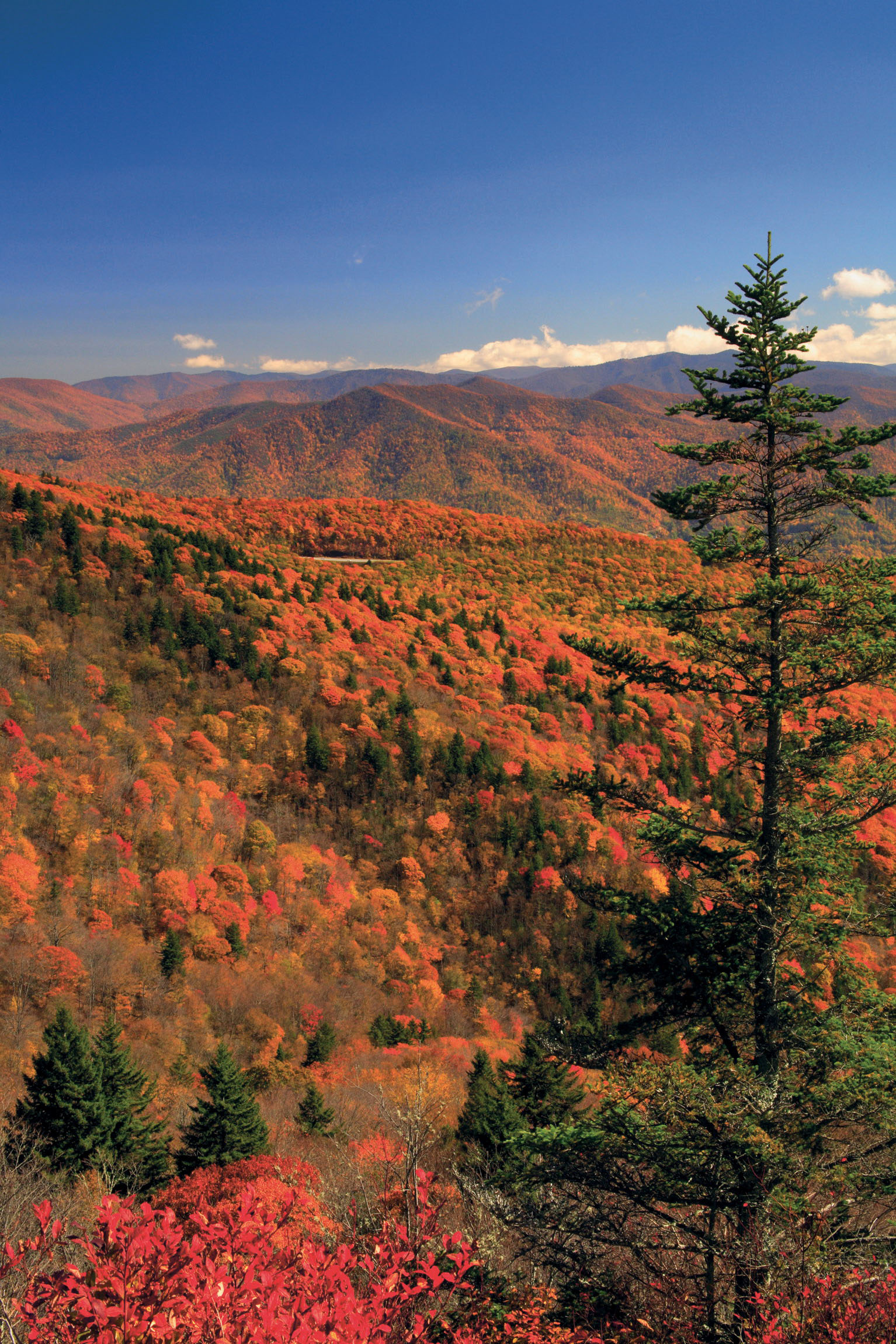
BLUE RIDGE PARKWAY, VIRGINIA TO NORTH CAROLINA
The iconic Blue Ridge Parkway rises and falls like a roller-coaster track running from Virginia’s Shenandoah National Park to North Carolina’s Great Smoky Mountains National Park. Most bikers budget about 10 days to complete the 469-mile (755km) route, which crosses four national forests and features 176 bridges, more than two dozen tunnels and hundreds of historic sites. Riders will experience the America that inspires patriotic songs: uninterrupted forests, burbling rivers, splashy waterfalls, vibrant wildflowers or foliage (depending on the season), and mountains haloed in clouds. Roadside diversions abound, such as the Blue Ridge Music Center, Julian Price Memorial Park and Craggy Gardens. Time your visit to Waterrock Knob with the sun’s sky spectacle.
Start // Shenandoah National Park near Waynesboro, Virginia
End // Great Smoky Mountains National Park near Cherokee, North Carolina
Distance // 469 miles (755km)
GREAT ALLEGHENY PASSAGE (GAP), MARYLAND TO PENNSYLVANIA
The chirps of bike bells have replaced the toots of train whistles that once rang through the corridors of the Great Allegheny Passage (GAP). The 150-mile (241km) biking and hiking trail (no cars allowed) sprang from mostly abandoned railbeds laid between Cumberland, Maryland. and Pittsburgh, Pennsylvania. The trail is flat and leisurely, and coasts by some remarkable landmarks. On the 13-mile (21km) Frostburg-to-Meyersdale leg, for example, the wow list includes the Mason–Dixon Line into Pennsylvania; the 3,300ft-long Big Savage Tunnel, which was named after the stranded 18th-century surveyor who had offered himself up as food to save his men; the Eastern Continental Divide, the trail’s highest point at 2390ft; and the curved Keystone Viaduct. Charming towns such as Confluence, on the Youghiogheny River, and Ohiopyle, a hyperactive hub of outdoor activities, entice bikers to hop off and stay awhile.
Start // Cumberland, Maryland
End // Pittsburgh, Pennsylvania
Distance // 150 miles (241km)
© Pat & Chuck Blackley | Alamy
autumn foliage on the Blue Ridge Parkway, viewed from Waterrock Knob
- EPIC BIKE RIDES OF THE WORLD -

A CIRCUIT OF SAN JUAN ISLAND
A breezy half-day spin around San Juan Island passes fragrant lavender farms, groves of misty pines, gorgeous coastline, and pods of orcas.

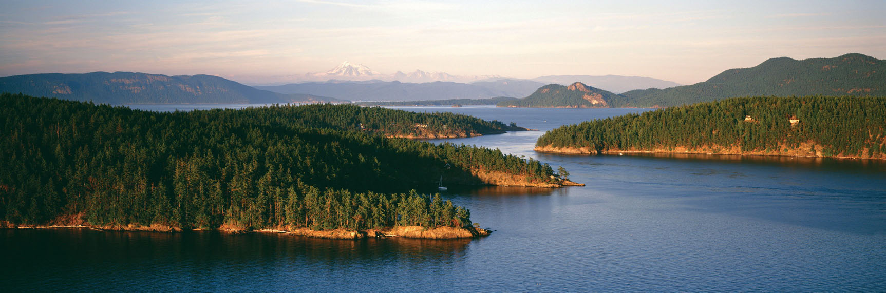
Nestled between Seattle and the Canadian border in the postcard-perfect Puget Sound, San Juan Island is one of several that comprise the archipelago of San Juan Islands. Each of the islands are filled with stunning sights and quaint diversions that make a lovely escape for casual cyclists. Each island also has a particular appeal for people who love to travel with their bicycle – the laidback cruising on Lopez Island versus the slightly more heart-racing terrain of Orcas Island – but the picturesque San Juan Island is just right, offering maximum views and a taste of adventure that is approachable for a wide range of riders.
I discovered the bicycle-friendly roads that circle San Juan Island offer something new around every bend – rocky outcroppings that plunge into sparkling waves, lofty groves of Douglas fir, migratory birdlife, bucolic farms and miles of coast. But this 35-mile (56km) ride has just as many excuses to get off the bike, including a pair of picturesque harbour towns, roadside farm stands, and historic sites that speak to the region’s colourful past. The biodiversity of such a small island is fascinating – from dense conifer forest and open farmlands to picturesque beaches. Modestly rolling terrain, 247 annual days of sunshine, and breathtaking scenery makes it an ideal destination to ride.
My partner and I began at the island’s main port, Friday Harbor, connected by frequent ferry service to Washington. After fuelling up on breakfast at one of the harbourside cafes we were on our way.
Heading south out of town on Argyle Rd, we followed the signs to the American Camp visitor center, one of the two former 19th-century military camps that make up the San Juan Island National Historical Park. A ranger was on hand answering questions about the so-called Pig War, an 1859 boundary skirmish between the British and the US. The conflict owes its colorful name to the incident that sparked it: a dispute between an American farmer and an employee of the Hudson’s Bay Company who owned an unruly pig. Fortunately, the pig was the only casualty.
© Danita Delimont | Alamy
looking out over the San Juan archipelago with Mt Baker in the distance
A few more miles south and we reached South Beach, which has incredible views across the Strait of Juan de Fuca to the snow-capped drama of the Olympic Mountain range. We continued south to the Cattle Point Lighthouse along a steep bluff and paused at pull-offs for mesmerising views of Vancouver Island, Olympic National Park and Port Angeles.
Continuing west and north we made our way to Lime Kiln Point State Park – known to the locals as Whale Watch Park – which is one of the island’s most popular spots for a picnic. If you’re here in the summer, you have a good chance of spotting a pod of orca whales. There are volunteer whale watchers at the most popular overlooks, scanning the waves for orcas and other species of whales that include gray, humpback, and minke. This is a good excuse to park the bike, as the area is great to explore on foot. We wandered around an historic lighthouse, an interpretive centre with hands-on exhibits and displays about the orcas, and an ancient lime kiln. This is where you should top-up your water as well, as the slightly more vigorous riding is about to begin.
“Volunteer whale watchers scan the waves for orcas and other species of whales that include gray, humpback and minke”
Leaving Lime Kiln Point, the road gains a couple of hundred feet of elevation, passing some of the most spectacular coastal sights on the entire ride. Over the hill, we cruised down to San Juan County Park. If you missed the whales at the first stop, try again; the unfortunately named Smallpox Bay is another good spot to look for the pods. This part of the island is home to all kinds of other wildlife as well, including deer and bald eagles. Turning left on West Valley Rd, we rolled past the curious gang at the Krystal Acres Alpaca Farm – which has a great gift shop of locally made goods – before seeing signs for English Camp. Situated on an open, grassy patch, this is another good place for a rest.
THE ORCAS OF SAN JUAN ISLANDS
The San Juan Islands host three resident pods of black and white orcas – a population of just over 80 whales, many of whom are known on a first-name basis by the locals. The orcas call these waters home between May to October. If you want to see them up close, consider a kayaking excursion – but your chances are just as good to spot them as they swim near the shore.
As we continued down the road toward Roche Harbor, we started thinking about lunch. Locals recommended the Westcott Bay Shellfish Company, a small family farm that produces deliciously briny oysters and has no-frills picnic tables where you can enjoy the sun, and shuck your lunch. But we were in the mood for something a bit heartier, so headed into town.
Centred around a tidy port and the stately Hotel de Haro, the marina at Roche Harbor is a charming lunch stop. Lime production was a major industry here during the late 19th century, but these days the small harbor is a magnet for yachting retirees from the Pacific Northwest. Explore the lanes of the historic village before making your way to the San Juan Islands Sculpture Park, a 19-acre park with more than 150 works by local and international artists, including some amazing kinetic sculptures.
Back in the saddle, it was a straight shot back to Friday Harbor – just under 10 flat miles (16km) on Roche Harbor Rd. Halfway back, we passed the lovely Lakedale Resort – a lakeside hotel with some options for glamping – before arriving at the final diversion, San Juan Vineyards. We did a bit of tasting (we earned it!) before bringing a glass out to the patio and taking in the warm evening light. A quick three miles (5km) more brought us back to the start in Friday Harbor, for hot showers and an elegant dinner. NC
TOOLKIT
Start/End // Friday Harbor
Distance // 35 miles (56km).
Getting there // Get to the island via the Washington State Ferry from Anacortes (www.takeaferry.com) or from Seattle’s seasonal Victoria Clipper. Seasonal ferries also depart from Bellingham or Port Townsend.
Bike hire // There are plenty of bike rental options in Friday Harbor, including high-end road bikes.
Where to eat/stay // Friday Harbor is San Juan Island’s largest town, and has a host of dining and sleeping options. Romantic B&Bs are scattered all over the island.
When to ride // The best time of year for a visit is between late April and early September.
More info // For complete information on visiting the island, including cycling resources, see www.visitsanjuans.com.

© mlharing | Getty Images
the San Juan Islands have three pods of resident orcas
- EPIC BIKE RIDES OF THE WORLD -
MORE LIKE THIS
ISLAND RIDES
VIEQUES ISLAND, PUERTO RICO
Six miles (9½km) off the southeastern coast of Puerto Rico, Vieques is a little strip of paradise – just 21 miles (38km) long and four miles (6½km) wide. Much of this enchanted place was owned by the United States Navy until 2003, when two-thirds of the island transitioned from a bombing range to lush nature reserve. Pedal down its long, dusty roads to find secluded beaches otherwise inaccessible by car. Many of the best of these have no names, but Red Beach is worth seeking out; the blonde crescent strip of sand lies beyond the cracked asphalt airstrip of the former Camp Garcia. Even during the high season (between late November and May) you’ll have the place mostly to yourself.
Tour // Black Beard Sports (www.blackbeardsports.com) has rentals and leads tours
NANTUCKET ISLAND RIDE, USA
Filled with New England ambience, history, and fresh-air vistas, Nantucket is a relaxing destination that’s perfect to explore by bike. The island is only 14 miles (22½km) long and three and a half miles (5½km) wide, so a dedicated cyclist can spin around its entirety in one day, but you’ll be better off to take some short rides around town and to the outlying beaches. Start with the boutiques and restaurants on the cobbled streets of historic Nantucket Harbor before navigating the network of smooth bike-paths past ocean views, migratory birds, and windswept beaches. Refuel on bowls of chowder among the rows of neat gray-shingled cottages in the old fishing village of Saiconset.
Bike hire // The Island Bike Company (www.islandbike.com) has a range of bikes, including cruisers and roadies
DINGLE PENINSULA, IRELAND
Between the craggy range of mountains and rocky cliffs that plunge into the Atlantic, the Dingle Peninsula is a joy for cyclists, who can ride a demanding day-long loop that passes historic ruins, roaring coastline, and amazing beaches. The peninsula is something of an open-air museum, dotted with more than 2000 Neolithic-Age monuments built between 4000BC. and early Christian times. The village of Dunquin has many crumbling rock homes that were abandoned during the famine. You’ll also pass the Gallarus Oratory, one of Ireland’s most well preserved ancient Christian churches. As you near the end of the loop, pull off for a quick stop at the 12th-century Irish Romanesque church with an ancient cemetery before returning to Dingle Town, where you’ll find plenty of pubs (many of which are hardware stores by day) to toast the adventure.
Start/End // Dingle Town
Distance // 25 miles (40km)

© Jan Miko | Shutterstock
there are few straight roads on the Dingle Peninsula, Ireland
- EPIC BIKE RIDES OF THE WORLD -

FAMILY BIKEPACKING IN ECUADOR
Picturesque Quilotoa Loop feels suitably off-the-beaten-track, but with a range of comfortable digs along the way, cyclists can recharge before tackling Ecuador’s tremendous inclines.
For those unfamiliar with the topography of South America, let me assure you of this: the Ecuadorian Andes are a deeply crumpled land. A slim band squeezed between the expanse of the Pacific Coast and the vast sprawl of the Amazon, it abounds with microclimates, determined more by geography and altitude than by any season. Within these folds, one steep-sided valley dovetails into the next. Cradled between two volcanic ranges, they form the Avenue of the Volcanoes, as coined by Alexander von Humboldt, the Prussian naturalist who journeyed through the continent in the 19th century.
Big mountains, big views... and, above all, big climbs: adventurous cycling, without doubt. But family friendly? Yes and, somewhat surprisingly, very much so.
We shared our Ecuadorian adventures with three brothers I’d first met while cycling through the country three years prior. Mountain guides by trade, they lived offgrid on an organic family farm outside Quito. In the interim, we’d kept in touch – and we’d all had children. When the chance came to visit Ecuador once again, this time I travelled with my partner and our two-year-old son Sage, so we might experience this beautiful and unfeasibly rugged country together.
In any shape or form, this ride would have been epic enough. Apart from the quiet dirt tracks, small mountain settlements, and fluffy roadside llamas, its backdrop was nothing short of spectacular: high altitude Ecuadorian paramo, the alpine tundra for which the country is known, and the emerald-tinted, 2mile (3.2km) wide Quilotoa crater lake, a definitive highlight along the Avenue of the Volcanoes.

© Cass Gilbert
pedalling into the wilds of Ecuador
But factor in no less than eight bicycles and five accompanying trailers, charged with a payload of children ranging in age from six months to three years, and such a journey takes on an even more memorable character. Despite the afternoon downpours and the occasional synchronised meltdowns, our pint-sized expedition proved to be an incredible life experience for everyone.
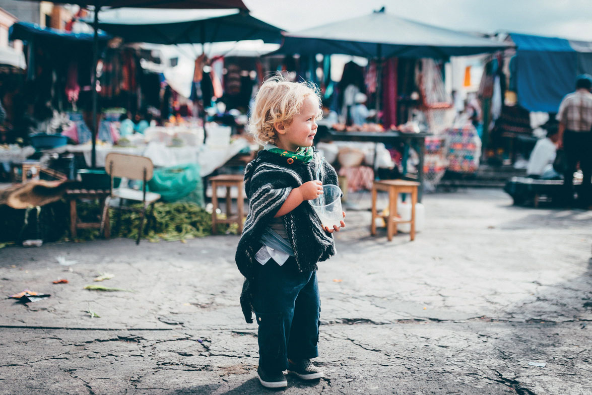
Together, we blazed a trail of family mayhem through the countryside. We rubbed shoulders with poncho-clad horse riders, picnicked amongst fields of quinoa, visited an indigenous market, and lingered in village playgrounds.
We kept distances short, and tried to harmonise riding times with napping schedules. When our three toddlers needed a break, we stopped and played football, helped them climb trees, or just explored the land. And what a land it was. A fertile patchwork of vertiginous fields clung to steep-sided slopes, surrounded by both soaring peaks and crumbling canyon cliffs. Pigs scuffled around by the road, men sauntered by with machetes on their hips, and women crammed their colourful shawls with fresh corn, their felt hats peeking out through the foliage.
MARKETS
Ecuador’s markets are not to be missed: vibrant colours, towering displays of food and a real sense of community. Fresh fruit juices and delicious snacks abound – grilled plantain is safe to eat, and a sure-fire toddler favourite. Usurping the main square each Saturday, there’s Zumbahua’s market – at the beginning of the Quilotoa Loop. Or, as a separate trip, don’t miss Otavalo, the best place to stock up on beautifully knitted jumpers and ponchos for children.
“Reaching the summit was rewarded with a feast of local produce, cheese and ripe avocados that had filled our panniers”
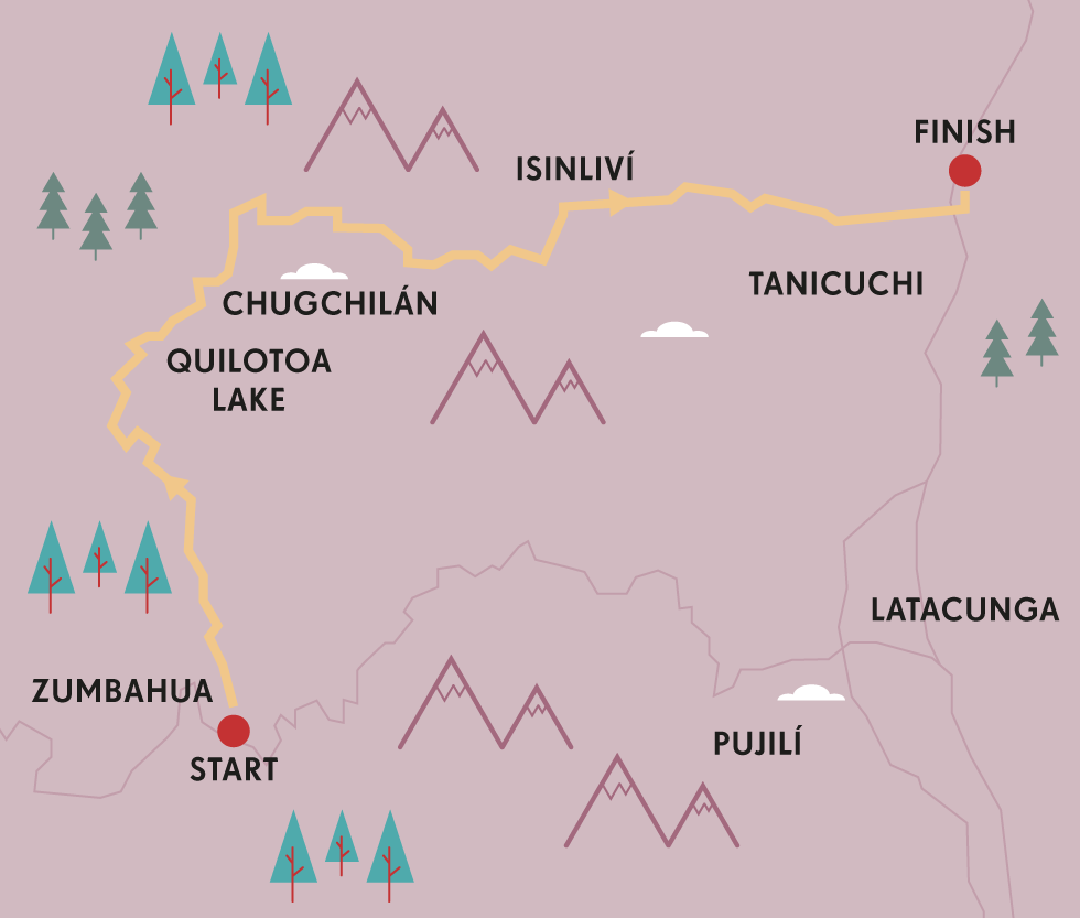
The route itself looped south-east through Ecuador’s Central Sierras. After stopping to applaud the natural watery wonder of Quilotoa, and scout briefly along the knife edge of its crater, it took us through the small settlement of Chugchilán, where we detoured into the dewy delights of the Illiniza Cloud Forest. There, fingers of mist curled through the trees, enveloping the land, filling every nook and cranny with silence. When the sun occasionally permeated through, it was subtle and shadowless, painting the mountains in gigantic, camouflaged swatches.
Up and down we rode, rarely a flat moment for respite. Climbs had our derailleurs clattering frantically through the gears, spinning our legs in the lowest cadences we could find, the ballast of our toddler cargo weighing us down. In immediate riposte, descents demanded we pull on brake levers like reins on a horse, lest our trailers shunt us forwards. Added to this, the terrain was often bumpy, sometimes even cobbled. Yet when I looked back to check on Sage, more often than not he was sound asleep, oblivious to our efforts.
Travelling over the winter holidays, we celebrated Christmas in Isinliví, a picturesque settlement perched in one of the region’s verdant valleys. As we came to appreciate, South Americans know how to party, whatever time of the year. The main square awash with revellers, countryside cowboys and a roving brass band that relentlessly circled its stony streets. To Sage’s delight, it even boasted an antiquated funfair, featuring a merry-go-round that spun with dizzying speed.
Isinliví was also our last staging post before we tackled the longest climb of the trip, a Herculean undertaking that involved 1000m in altitude gain, on an unpaved road at that. Inevitably, this final undertaking had us all off the bikes and pushing, our Lilliputian team of toddlers enthusiastically lending a helping hand too. When the summit finally came, it was rewarded with a feast of local produce, cheese and deliciously ripe avocados that had filled our panniers. Then, with a last gaze out towards the highland paramo, we dived into the whirligig descent that lay ahead, the flags of our trailers snapping in the wind.
Despite the diminutive daily distances, I won’t lay claim that family bikepacking is easy; without doubt, it poses its own set of mental and logistical challenges, quite apart from any physical toils. But I couldn’t more highly recommend trying one out, wherever it may be in the world, for however many days you may have. Gather the troops and brew up a plan. Choose a route that everyone will enjoy. Take the time to luxuriate in being off the bike as much as you are on it. I can guarantee that such undiluted family time will warm the heart and feed the soul. For everyone involved. CG
TOOLKIT
Start // Zumbahua
End // Lasso, on the Pan-American Hwy.
Distance // 68 miles (110km)
Getting there // Both Zumbahua and Lasso can be easily accessed by bus from Quito.
Where to stay // Hostal Llullu Llama in Isinliví. For ecominded luxury, the Black Sheep Inn, near Chugchilán.
What to take // Pack light and make use of traveller-friendly accommodation en route.
Climate // Put aside several days in Quito to acclimatise before heading into Ecuador’s high country.
Hot tip // Ecuador’s inclines can be long and unreasonably steep (but ultimately rewarding!).Trucks regularly ply Ecuador’s mountain roads. For a few dollars, flag down a driver, and enjoy a lift to the top of the next mountain pass.
© Cass Gilbert
keep spirits and sugar levels up with regular stops at street markets
- EPIC BIKE RIDES OF THE WORLD -
MORE LIKE THIS
FAMILY BIKEPACKING RIDES
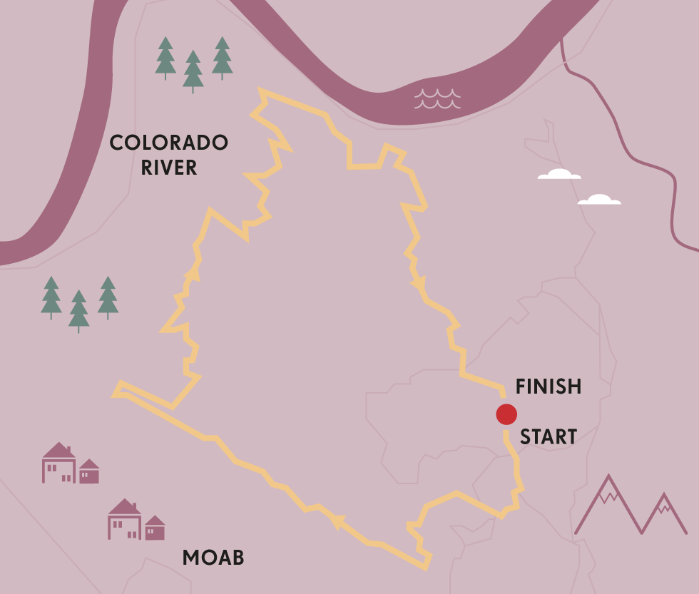
SALIDA, COLORADO, USA
The Great Divide Mountain Bike Route (GDMBR) is famed for its Herculean race, in which self-supported riders tear across the Rockies. But broken up in bite-size portions, it also has all the ingredients for a series of wonderful family bikepacking adventures. Indeed, it doesn’t get much better than the high grasslands and aspen groves above Salida, Colorado, especially during the technicoloured splendour of autumn. There, a dirt road loop can be formed using Aspen Ridge and the backbone of the GDMBR. Salida’s polished, historic redbrick downtown – distantly echoing an insalubrious past as a Wild West railroad settlement – also features a park in which to picnic, a playground, a climbing wall and a river to soak in. Kid trailers are almost as common as the dual suspension mountain bikes that roam the streets.
Start/End // Salida, Colorado
Distance // 52 miles (84km)
More info // www.bikepacking.com/routes/family-bikepacking-salida
WHITE RIM, UTAH, USA
Even within the vast expanse of the American South West, Utah holds its own particular appeal. There’s an inordinate number of national parks and natural wonders vying for attention: a medley of canyons, cliffs, buttes, arches and tabletops, hewn over millennia from its quintessential red rock. The White Rim Trail, in the south-eastern portion of the state, is a rare bicycle touring gem, simply because it’s difficult to imagine how a ride could be more perfectly formed. Located in the heart of Utah’s Canyonlands National Park – eroded into shape by the mighty Colorado and Green Rivers, this 97-mile (156km) loop boasts a succession of one superlative panorama after the next. Combine this with a wellpacked dirt road, sublime camping potential and complete, utter desert silence, and it’s everything you seek in a weekendsized adventure.
Start/End // near Moab, Utah
Distance // 97 miles (156 km)
More info // www.nps.gov/cany/planyourvisit/whiterimroad.htm
CONGUILLÍO NATIONAL PARK, CHILE
The Conguillío National Park lies at the northern tip of the Chilean Lake District, and envelopes the 3125m Llaima Volcano. It’s a lunar landscape where islands of fertile earth lie stranded between lava flows frozen in time – or at least until the next eruption. Quiet mountain roads make for great, if challenging, family bikepacking, combining an exploration of the park with a ride to Lonquimay, through the neighbouring Reserva China Muerta. Dotted through the area, standing nobly in tranquil groves, are the enchanting Araucaria araucana or ‘Monkey Puzzle’ trees, so named as it was thought that climbing them would flummox even a monkey. These bizarre, bandy, Seussianlike creations reach up to 40 m high, their tentaclelike branches surely protecting them from any primate intrusion while also fascinating children.
Start // Melipueco
End // Lonquimay
Distance // 50 miles (80km)

© James Schwabel | Alamy
riding through downtown Salida, Colorado
- EPIC BIKE RIDES OF THE WORLD -

COLORADO BEER BIKE TOUR
Year-round sunshine, world-class cycling, and hundreds of breweries – quench your thirst after a long day on the bike with some of America’s best craft beer.
Iget off the bike, legs full of lead and heart thundering, face tingling from the wind and mouth full of cotton. If this was a typical ride, I’d grab my water bottle and find the nearest cheeseburger. But taking in the scenic regions of Colorado’s north by bike is anything but typical. On this ride, I’ll savor the marriage of the region’s two perfectly complementary pastimes at every stop: mind-blowing cycling and mouthwatering beer. A blissful 20-mile (32km) descent from the mountains and an icy pint of citrusy, grassy, dry-hopped double IPA? This is my kind of recovery regimen.
Colorado has long been a hotspot for road cycling and mountain biking, and boasts more microbreweries per capita than anywhere else in the US. For a beer-loving cyclist, it’s a no-brainer.
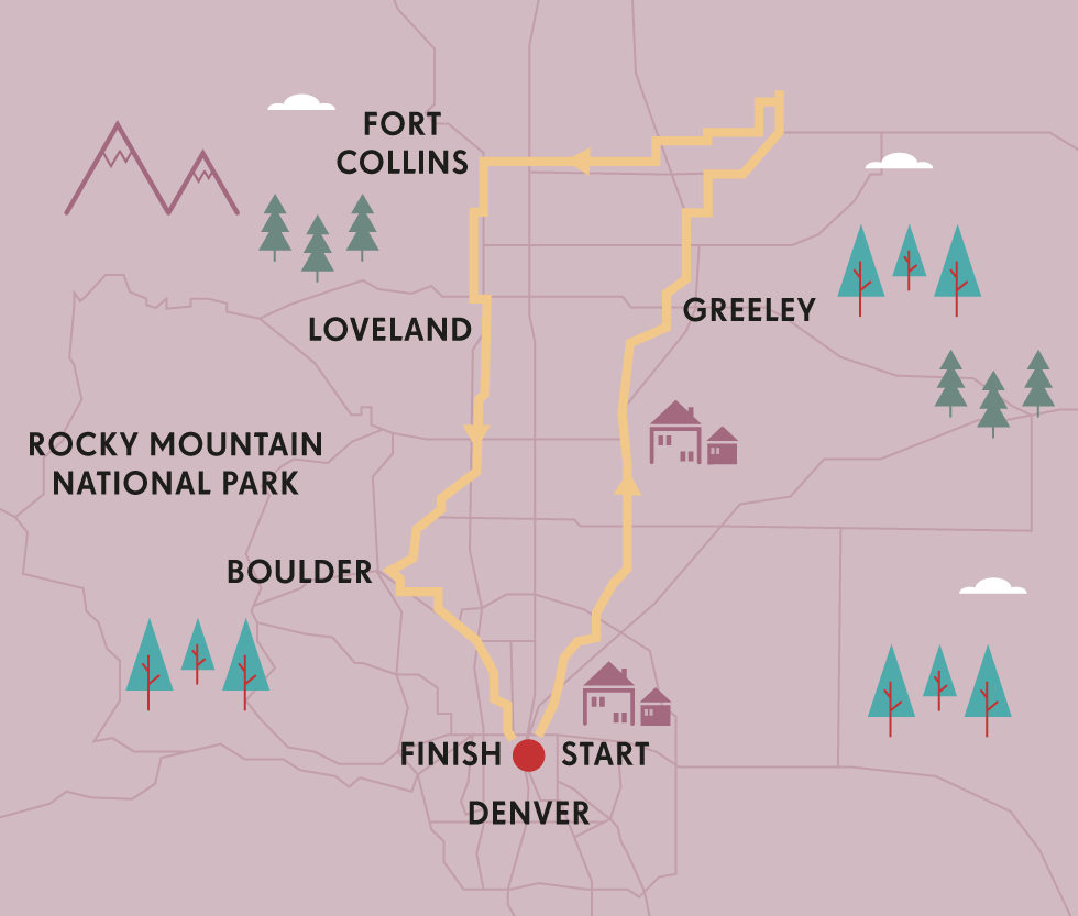
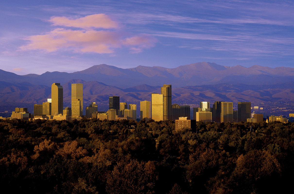
I start in the state’s capital, Denver, which has transformed from a frontier cow town into an urban capital of the American west. The city itself might be destination enough for casual cyclists – an excellent bike network includes long, leisurely routes along the Platte River Parkway, the Cherry Creek Bike Path, and trails to neighbouring suburbs. You can even use the excellent B Cycle program, which has bikes stationed throughout the city. But one look at the peaks of the ‘14ers’ (local speak for a 14,000ft mountain [4267m]) looming on the horizon, and I knew that a serious two-wheel adventure was ahead.
Denver is the perfect embarkation point for my beer-themed trip. I was a month early for the endless tasting at September’s Great American Beer Festival – but consoled myself with a fun, boozy overview of the city’s breweries from the Denver Microbrew Tour. A few of my favourites include the Great Divide Brewing Company, where the spectrum of seasonal beers are all beautifully balanced (be careful, many of them are over 7%), an outpost of the excellent Breckenridge Brewery, and the weekly rotation of taps at the Denver Beer Co.
© Bill Ross | CORBIS
Denver at dawn
Fully hydrated and rested up, I hit the road. My next major stop would be Fort Collins, a college town that perfectly merges Colorado’s beer and bike cultures. Although a serious cyclist could do the trip in a long day, I took the 100-mile (161km) route into two days with an overnight in Greeley. With the pancake-flat roads and a tailwind, I blasted out of Greeley for a cruise through the unending green expanse of the Pawnee National Grassland, a magical sea of swaying hip-high grasses that were once prime buffalo hunting land. There’s something hypnotic about the rhythmic sway of the prairie.
“Riding west brought me to Fort Collins, the essence of the trip, its bike-packed streets dotted with great breweries”
Navigating a few extra miles brought me to the Pawnee Buttes, two 300ft formations that leap dramatically out of the flatlands. Aside from free-roaming cattle, these back roads are mostly free from traffic, and toward the end of the day I caught the flash of a white-tailed antelope bounding through the fields.
Riding west brought me to Fort Collins, which straddles Colorado’s topographical divide, at the point where the Rockies begin their rise. This town is the essence of the trip: the bicycle-packed streets of Fort Collins are dotted with great breweries. And the city is mad about cycling: the Fort Collins Bike Library offers free bikes to anyone who passes through.
THE COLORADO TRAIL
With some 535 miles (861km) of twisting singletrack, jaw-dropping views, and rollercoaster elevation, the Colorado Trail is one of the world’s great long-distance mountain bike journeys. Riding the entire trail – from Denver to Durango – takes about 20 days, and requires re-supply in mountain towns along the way. For the more casual rider, there are numerous day-rides that will give you a taste of this epic adventure. For complete information: www.coloradotrail.org.
This first stop in Fort Collins is the New Belgium Brewery. This employee-owned operation has brought its passion for bicycles, beer and sustainability to an international audience in recent years. The guides give me a playful walk through the facility that ends in a carnival-like tasting room before I head back to town for a stop at the Odell Brewing Company, a remarkable small brewery with the best IPA of the trip. If the sun was up, I would have hit the beer garden at Equinox Brewing, but the jagged horizon suggests that a good night’s rest is in order.
Anyone could close this loop by riding straight south on the relatively flat roads that skirt the edge of the Rockies. I’ve got a pint of stout or two to work off, so I’m up for the challenge of climbing Rist Canyon to Stove Prairie Rd. This route (loved by locals and a recent stage for the USA Pro Challenge) is tough, but the scenery is incredible. Ahead, mountains roll into view in shades of purple and blue. Behind, plains reach out in a checkerboard of green. All day, I’m surrounded by pines, massive boulders and rushing creeks. Heading south on Stove Prairie Rd, I lose all that elevation through the sweeping curves that lead to Loveland. Of course, there are plenty of places to fuel up in this small town as well, starting with the family-owned Loveland Aleworks, where the creative selection of taps is frequently rotating. This stop includes a pucker-inducing explosion of summer flavour with the Strawberry Sour.
The next day, I take the 35 miles (56km) between Loveland and Boulder in a few hours, allowing plenty of time for exploring the Boulder Creek Bike Path to end the penultimate day. Snuggled up against the Flatirons, this bohemian college town is in love with the outdoors. After chatting with the local characters on the Pearl St promenade, I grab a beer at Avery Brewing, and take a self-guided tour from the catwalk. The evening ends with some noodling guitar warriors at the Draft House, which brings in local bands every weekend. Another half-day in the saddle brought me back to Denver for a well-earned rest for my legs and my liver. NC
TOOLKIT
Start/End // Denver
Distance // about 350 miles (563km) in five or six days.
Getting there // Denver International Airport is an easy connection to many cities in the US and has several daily routes to Europe, Japan, Canada and Latin America.
Bike hire // A number of Denver shops will rent bicycles suitable for multi-day trips, including The Bicycle Doctor (www.bicycledr.com), and Bicycle Village (www.bicyclevillage.com). The big REI (www.rei.com) in Denver also rents bikes and camping equipment, and can arrange bike shipping.
Where to drink // The Beer Drinker’s Guide to Colorado has reviews and maps to Colorado breweries. Denver Microbrew Tour offers a great brewery overview.
More info // See www.bikedenver.org and www.denvergov.org, which has downloadable bike maps.

© Shutter18 | Getty Images
autumn colours at Boulder Creek
- EPIC BIKE RIDES OF THE WORLD -
MORE LIKE THIS
REFRESHED RIDES
CALISTOGA WINE TOUR, USA
A weekend amble through California’s wine country is an extremely popular way to get a taste of the region north of San Francisco. Although Napa’s roads can get clogged with tourists, a good alternative is to ride the relatively quieter roads surrounding Calistoga. Pedal north out of town on Hwy 29 and take Old Toll Rd up a side valley. A steep, shaded climb will pass a couple of family wineries before rejoining Hwy 29 and reaching the summit at the Robert Louis Stevenson State Park – an excellent place to rest, picnic, and take in the views. Coast downhill to Middletown and east through the lovely valley that’s home to the Guenoc and Langtry Vineyards. Then climb Butts Canyon and descend into the flowering meadows of Pope Valley. From here, connect to the celebrated (car-free) Silverado Trail, through the adorable downtown of St Helena, and head back to the start.
Start/End // Calistoga
Distance // 62 miles (100km)
VALLEY BEER TOUR, USA
The region of Western Massachusetts and southern Vermont gets called the Napa Valley of Beer for good reason – the clutch of creative craft breweries and excellent brew pubs makes it a beer-lover’s dream. Start this trip in Springfield, a half-day train ride from New York City. Here, you can enjoy old world beer-making traditions at The Student Prince, one of the best German restaurants in Western Mass. After a stein and a schnitzel, make your way along back roads to North Hampton, a college town with a number of great brew pubs, including the 40 taps of local and far-flung beers at Dirty Truth and the rowdy outdoor beer garden at the Northampton Brewery. This ride ends just across the Vermont state line at the The Whetstone Station Restaurant and Brewery, where riders can enjoy a view of the Connecticut River and refined small plates.
Start // Springfield, Massachusetts
End // Whetstone Station Restaurant & Brewery, Vermont
Distance // 66 miles (106km)
KENTUCKY BOURBON TOUR, USA
A ride filled with rich history, heady spirits, and Southern American charm, this trip takes in six of the best distilleries along the scenic, rolling rural roads of Central Kentucky. The terrain is moderately challenging (particularly with a couple of samples under your belt), so this is recommended for more experienced cyclists. Start in Lexington at the Jim Beam distillery, where you can get a detailed map of the region and turn-by-turn instructions. Along the route, you’ll sample America’s oldest spirit at the Heaven Hill Distillery, Maker’s Mark, Four Roses, Wild Turkey, and Woodford Reserve. In addition to the delicious bourbons, you’ll find rolling hills of bluegrass and picture-perfect horse farms.
Start/End // Lexington
Distance // 30 miles (48km)
More info // www.kybourbontrail.com

© Lottie Davies
showing you the way to the next whisky stop in Kentucky
- EPIC BIKE RIDES OF THE WORLD -

NORTH AMERICA’S PACIFIC COAST
With the shimmering Pacific horizon to your right and an endless ribbon of blacktop ahead, this ride traces the dramatic western edge of North America.

For cyclists who live to ride, this is a once-in-a-lifetime trip, the kind of experience that’s a culmination of years of daydreaming and months of planning. I’d wanted to ride an extended stretch of the Pacific Coast Hwy for years, but the challenge is no joke: the jagged western edge of the continent has plenty of long, tough climbs and lonely stretches of blacktop that demand tenacity and self-sufficiency. But the rewards make it one of my favourite rides. Sunsets enflame the horizon, dizzying cliffs drop into the crashing surf, and redwood giants tower above. Over the years, I’ve ridden plenty of beautiful miles on Hwy 1, but none more exciting than the stretch between Seattle and San Francisco – an epic 980 miles (1577km) with incredible sights, great camping and plenty of diversions.
Scores of cyclists make the southbound trip on the Pacific Coast Hwy every year – mostly in the summer. I took the trip solo, but the camaraderie of the riders who gather around nightly fires at the hiker-biker campsites balanced a month of solitary days in the saddle. I met John and Margaret, a pair of sweetly sardonic teachers sporting classic ’80s touring rigs, gadget-obsessed twin sisters from Victoria BC on their way to Los Angeles, and a handful of grizzled vagabonds attempting solo trips to Mexico and beyond. And everyone had a story – about troubleshooting a mechanical nightmare in the rain, or a truck-driving redneck with an axe to grind, or climbs that seemed never-ending.
Although I was determined to camp – there are established campgrounds every 50 to 60 miles (80 to 96km) along the route with sites designated for cyclists – there are also plenty of opportunities for so-called ‘credit-card’ touring, for riders who travel light and prefer a soft bed.
The complete trip between Seattle and San Francisco can be done in 15 days (for a powerhouse cyclist with very little gear), but I took twice as long with a fully-loaded touring bike. Although I met plenty of riders ticking away miles on a tight schedule, I knew quickly that this wasn’t my style. The flexibility of my itinerary enabled some of the trip’s rewarding memories: pints of world-class beer at the Six Rivers Brewery, naps under swaying redwood trees, and clifftop whale-watching. In other words, little pieces of heaven.

© Richard Price | Getty Images
Cape Sebastian State Park in Oregon
Before leaving Seattle, I spent an extra day or two fuelling up on the city’s excellent food scene. Exploring the narrow alleys and bustling stalls of Pike Place Market, I got some fancy campfire supplies for the days ahead, and dug into the city’s best: steaming bowls of ramen and fresh-that-day crab.
I began my detours as soon as the trip began, tacking on several days to ride around the Olympic Peninsula. With misty rides on near-empty roads, the trip began with a surreal tranquility. It didn’t take long to get what I came for: brackish ocean breeze and mind-blowing vistas, as I cruised along spine-tingling cliffs, shovelling down snacks at quirky little roadside bodegas.
It took a long three days to get around the whole thing, but it was worth every minute: views of the Strait of Juan de Fuca, quiet farms, remote beaches and ancient forests. The camping was a superlative highlight.
CONTINUING ON...
Although the ride from Seattle to San Francisco is a favourite section of the Pacific Coast because of the quality of the scenery, the relatively quiet roads and the superlative options for camping, a cyclist with enough time and energy can keep pedalling for weeks along the Pacific. The stretch from San Francisco to Los Angeles is also a scenic stunner, though narrow shoulders and heavier traffic make it more of a challenge.
More of the best Pacific Coast lies in the coastal campgrounds of Oregon, which make up the bulk of the trip. I loved Fort Stevens State Park, a 4200-acre park that has incredible biodiversity – everything from gusty dunes to freshwater wetlands – and a number of historic military sites from the WWII fortification of the coast. Many of the coastal Oregon parks further south made me consider lingering a bit longer than planned, like Cape Lookout State Park, where the beachside hiker-biker sites are blissfully remote from the RV sites.
Although the camping in Oregon is the best on the trip, I discovered the most jaw-dropping vistas south of the California border. The ride here is a constant parade of awe-inspiring natural beauty, particularly when you get to the smoothly paved Avenue of the Giants, a byway surrounded on all sides by towering old-growth redwood trees. (If you’re into mid-century kitsch, there are even several that you can ride through, near Leggett.)
Riding along the edge of the so-called Lost Coast, I paused for a breather and saw the white flumes of whales, in their migration to Mexico. As I pedalled further south, I slowed for the seaside holiday towns lining the coast of Northern California. In one of them, historic Mendocino, there’s a tidy grid of cute shops and four-star restaurants next to gorgeous headlands. I also paused for fresh seafood in Point Arena – which has an amazing bakery and an historic theatre.
By the time San Francisco got near, I was in great shape for the most challenging section of the ride, Sonoma County. Thankfully, this also has the best views, with rock formations in the waters that rival the dramatic power of the famed Big Sur coastline south of San Francisco. Here, Hwy 1 offers paved rollers along the cliffs – three days in the rhythm of 20 minutes of lung-burning climbing followed by 5 minutes of glorious descending.
Reaching the coastal farms that supply San Francisco’s famed foodie culture, I knew the end was near, and stopped into Point Reyes Station for fresh oysters and locally made triple cream cheese at the Cowgirl Creamery. By the time I crossed the Golden Gate – 28 days and 980 miles (1577km) after my departure – this epic trip proved that the most magical part about going somewhere was the process of getting there. NC
“The ride is a constant parade of awe-inspiring natural beauty, particularly when you get to the Avenue of the Giants”
TOOLKIT
Start // Seattle
End // San Francisco
Distance // 980 miles (1577km)
Duration // Just over two weeks, though it’s much more enjoyable with three weeks or more.
Getting there // If you fly in and out of Seattle, you can return with your bike via Amtrak at a modest additional fee, or ship your bike for a flat fee through REI (www.rei.com).
Where to stay // Hiker-biker campsites at the Oregon State Park System are only US$5 and they never turn away cyclists – even if the park is sold out.
What to read // Bicycling the Pacific Coast by Vicky Spring & Tom Kirkendall
When to ride // You can do this trip any time of year, but summer and autumn are best.

© earleliason | Getty Images
fog rolls in off the Pacific along the North California coast
- EPIC BIKE RIDES OF THE WORLD -
MORE LIKE THIS
WATERSIDE RIDES
CRATER LAKE RIM RIDE, USA
Riders in the Pacific Northwest get a certain far-off look in their eye when they talk about the otherworldly ride along the edge of Crater Lake, one of the most rewarding day-long rides in the Western United States. The gorgeous, deep blue waters of this volcanic lake in southern Oregon have a visual power that leaves a big impression – it reflects the surrounding peaks and sky like a mirror, inspiring panoramas that will take any cyclist’s breath away. (Or maybe that’s the 3000ft of elevation change at high altitude.) A strong cyclist could do the 35-mile (56km) loop around the lake in three or four hours. But, regardless of your skills, the spectacular road is almost never flat – you’ll be climbing or descending most of the day.
Start/End // Crater Lake Visitor Center
Distance // 35 miles (56km)
GERMANY’S BALTIC COAST
With the sea as your constant companion, a multi-day tour of Germany’s Baltic Coast offers gorgeous beaches, rugged cliffs, regional seafood and the bustle of historic coastal villages. Begin this summer tour of the coast in Flensburg and head east, towards Fehmarn Island, an excellent place to observe migratory birds. Along the way, you’ll see many of the seaside resorts lining the Bay of Lübeck that have been resplendently restored. A stop several days later in Lübeck will allow you to refuel with the city’s famed marzipan treats before you pedal on to the quaint Unesco-listed towns of Wismar and Stralsund – two Hanseatic League trading centres of the 14th and 15th centuries. The second island on this trip, Rugia, presents more excellent cycling, with dramatic cliffs, white beaches, and the wild beauty of Jasmund National Park.
Start // Flensburg
End // Jasmund National Park, Sassnitz,
Distance // 279.5 miles (450km)
THE FRENCH ATLANTIC
A trip along France’s longest cycling trail, appropriately named La Vélodyssée, can be enjoyed as a day-long cruise or a multi-day epic; the full trail is about 745½ miles (1200km) stretching from Brittany in the north to the Spanish border. With the Atlantic in view for most of the ride, this journey is best be done at an easy pace that allows you to savour the region’s pleasures – including cute seaside B&Bs, historic sea ports, and beautiful beaches. Although each of the route’s 14 sections has distinctive charms, seafood lovers should make it a point to include the path from La Barre-de-Monts to Les Sables-d’Olonne, which will allow you to tuck into fresh oysters. The section between Arcachon and Léon is also stunning, as the path passes deep forests and inland lakes.
Start // Brittany
End // Bayonne
Distance // 745½ miles (1200km)

© Hemis | Alamy
riding the Côtes-d’Armor in Brittany, France
- EPIC BIKE RIDES OF THE WORLD -

MOUNTAIN BIKING IN MOAB
Few places get mountain bikers as excited as Utah’s Moab – a desert dreamscape of slickrock and singletrack revered for its riding culture and infamous 24-hour race.
When my riding partner dismounts and picks up his bike, I figure there’s no shame in doing the same. I had a feeling that any attempt to ride this particular section of trail would end with me biting some dust, sprawled on my back with all the grace of an upended blister beetle – again – but I might have given it a stab.
That’s if I weren’t exploring Behind the Rocks with Mountain Bike Hall of Fame grandee John Stamstad, and if he considers something to be unrideable, then the argument is effectively over. Stamstad is the emperor of endurance cycling – a reputation he earned, in part, right here – on the route of the legendary 24 Hours of Moab cycle race that annually ran through the Utah desertscape from 1994 to 2012.
Having effectively invented solo 24-hour mountain-bike racing and pioneered the pursuit of Great Divide racing across America, Stamstad once set a world record by cycling a mountain bike across off-road terrain for 354.5 miles (570km) in 24 hours.
Suffice to say, when he gets off his bike, it’s for good reason. This spot is named Nose Dive, and bits of broken bicycles lie scattered in the dust all around – the bleached bones of the foolish few who have attempted to ride the dive. ‘I used to be able to pick a line through here,’ Stamstad laments. ‘But the jeeps have destroyed it now. You can’t ride out of it anymore, so there’s no point killing yourself on the descent.’

© Jordan Siemens | Getty Images
looking out over the mesas around Moab
Stamstad never actually won the 24 Hours of Moab – not least because the last time he did it, he insisted on riding a single-speed bike (and still came second) – but he’s done so many laps of the legendary circuit that he could ride it with his eyes shut (and very possibly has). The race route is a shortened version of the Behind the Rocks Lunatic Loop, a 28-mile (45km) trail that is probably Moab’s least popular. A ‘sandy sufferfest’ is how the guy in Poison Spider Bicycles described it when he heard where we were heading.
But I’m desperate to experience the epic course, and now the event is in hiatus, this is the only way. My legs are eternally grateful that we only have to ride the route once, and the rest of me soon discovers that July is not a month when even Stamstad would want to be riding multiple loops for 24 hours on the trot. We’re out early in the morning – long before the day comes to the boil, when temperatures in the rare shade simmer at around 100°F (38°C) – but perspiration quickly drenches my face and fills my eyes.
Stamstad shows me around every nook and cranny of the course, recounting tales from the trails as we roll. At one point I go sailing over the bars during a technical descent, and he thoughtfully attempts to spare my blushes by describing how he once passed the erstwhile race leader at this very place, as the guy lay on the ground with concussion. I’m obviously travelling somewhat slower, and it’s only my pride that gets concussed.
24-HOUR RACING
Another Mountain Bike Hall of Famer, Laird Knight, created 24-hour MTB racing – where riders attempt as many loops of a technical off-road course in 24 hours as possible – as a team pursuit. In 1996 Stamstad entered a 24-hour race in Canaan as a team, but all four names on the sheet were a variation of his own. He did the event solo, beat most of the field and invented a new form of endurance racing.
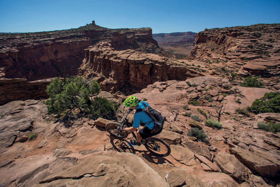
I get back into the saddle and we continue, rounding a stunning golden edifice of almost Uluru proportions, which my companion grinningly informs me is known as Prostitute’s Butte, because of how it looks from the air. The trail then runs across a seductive section of Moab’s iconic slickrock – smooth Navajo sandstone that appears sketchy, but actually grants knobbly tyres an uncanny amount of traction, allowing riders to roll over the most unlikely gradients while remaining rubber side down.
The 15-mile (24km) race circuit finishes shortly afterwards and we seek shelter from the inferno of the midday sun. At a diner in town, the menu includes an ‘All-day Mountain Bikers’ Breakfast’, which delivers a carb-laden load that would keep most riders fuelled for the duration of a 24-hour race.
Once the worst of the heat has passed, we explore the more popular routes that slither across the slickrock and skim the rim of the canyon, making Moab a hallowed haunt for mountain bikers, irrespective of the race. Incredibly, these classic tracks were laid down during the Jurassic period, and no human intervention has been required to make or maintain them as perfect MTB trails.
That said, the mega-popular, world-renowned 10-mile (16km) Slickrock Trail itself follows a series of white dots painted onto the rocks, which do jolt you out of the amber-tinted ambience of the natural surrounds somewhat, so Stamstad takes me on the wilder Amasa Back Trailhead route instead.
This adventure, another 10-miler, sees us ascend over 1000ft, climbing across sandstone all the way to a magical mesa top, with an astonishing vista across the Colorado River and Kane Creek. Beyond the rust-coloured desert, the La Sal Mountains on the horizon still have a dusting of snow, which seems almost impossible from the furnace of the canyon.
Numerous drop-offs, technical climbs and steep descents keep us on our game throughout this return route, and rolling around close to the canyon rim – which plunges away with hair-raising severity – demands serious concentration, but it’s not just the elevation that gives me goosebumps here.
Riding back to the trailhead, as thunder rumbles in the distance and forked-tongued lightning licks the distant range, it feels like I’ve ascended some sort of higher plane of mountain biking. And then I’m bounced out of my whimsical reverie by a red rock that has waited 200 million years just to throw me over the bars of my bike and bring me back to earth. PK
TOOLKIT
Start/End // Behind the Rocks/24-Hours of Moab route: US-191, just beyond Kane Springs Picnic Area; Amasa Back Trailhead: Amasa Back car park; Slickrock Trail: Sand Flats Road.
Distance // Behind the Rocks: 15 miles (24km); Amasa Back Trailhead: 10 miles (16km); Slickrock Trail: 10 miles (16km).
What to ride // A dual-suspension mountain bike.
Tour // Ride independently, or consult the experts at Poison Spider Bicycles (www.poisonspiderbicycles.com) for guidance, or to arrange a spot on the Porcupine Shuttle, which leaves daily, taking bikers to do the epic 32-mile (51km) ‘Whole Enchilada’.
When to ride // Spring and autumn deliver ideal conditions.
More info // www.utahmountainbiking.com
© ZUMA Press, Inc. / Alamy
navigating the sandstone Amasa Back trail
- EPIC BIKE RIDES OF THE WORLD -
MORE LIKE THIS
24HR MOUNTAIN BIKE RACES
THE 24H OF FINALE LIGURE, ITALY
Moab may have been the spiritual home of 24-hour MTB racing up until 2012, but the format conceived by Laird Knight and taken to the extreme by John Stamstad has spawned many classic events all over the world. One of continental Europe’s biggest all-day bike bashes is the 24-hour of Finale Ligure in Northern Italy. Since its launch in 1999, this iconic race has seen teams and soloists compete on separate singletrack circuits, both with stunning sea views over the Mediterranean. Around the race, the Mountain Bike Festival of Finale takes place, with various bike-related activities, plus entertainment, food and drink.
Start/End // Camping Terre Rosse
Distance // It’s a 4-mile(6.7km) circuit for solo riders, and a 6-mile (9.75km) circuit for team riders.
More info // www.24hfinale.com
THE STRATHPUFFER 24, SCOTLAND
Just in case the concept of doing a 24-hour mountain-bike race around a technical course doesn’t sound tricky enough, this event in the Scottish Highlands takes place in the icy grip of midwinter, when the trail is cloaked in inky darkness for roughly 17 out of those 24 hours. Tough teams of two, four and 10 take part in the race, with some superhard soloists also braving the chilly challenge. Tracks in the Torrachilty Forest are often under a layer of snow, which covers rock gardens, tree roots and other assorted obstacles. The event is held in mid January and begins with a Le Mans-style run to the bike.
Start/End // Torrachilty Forest, which is 3 miles (5km) from Strathpeffer
Distance // 7-mile (11km) circuit
More info // www.strathpuffer.co.uk
TRANS BAVIAANS, SOUTH AFRICA
Billed as the toughest single-stage mountain bike race in the world, the Trans Baviaans is a 24-hour MTB challenge of a completely different ilk. Instead of sending riders around loops while the hour hand travels around the clock face, this super-demanding race takes place across an unmarked linear course through the heart of the beautiful Baviaanskloof Wilderness Area. The route is punctuated by checkpoints that teams must visit, and the 143-mile (230km) distance from Willowmore to Jeffrey’s Bay needs to be completed within 24 hours. It’s only open to teams, and demands sharp navigation skills as well as high levels of endurance.
Start // Willowmore
End // Jeffrey’s Bay
Distance // 143 miles (230km)
More info // www.transbaviaans.co.za
© Westend61 | Getty Images
Finale is the base for an Italian 24hr mountain bike race
- EPIC BIKE RIDES OF THE WORLD -
RIDE THE WHITEHORSE TRAILS
Just under the curve of the Arctic Circle, in Canada’s ultra-remote Yukon Territory, Whitehorse offers magical mountain-bike trails beneath the midnight sun.
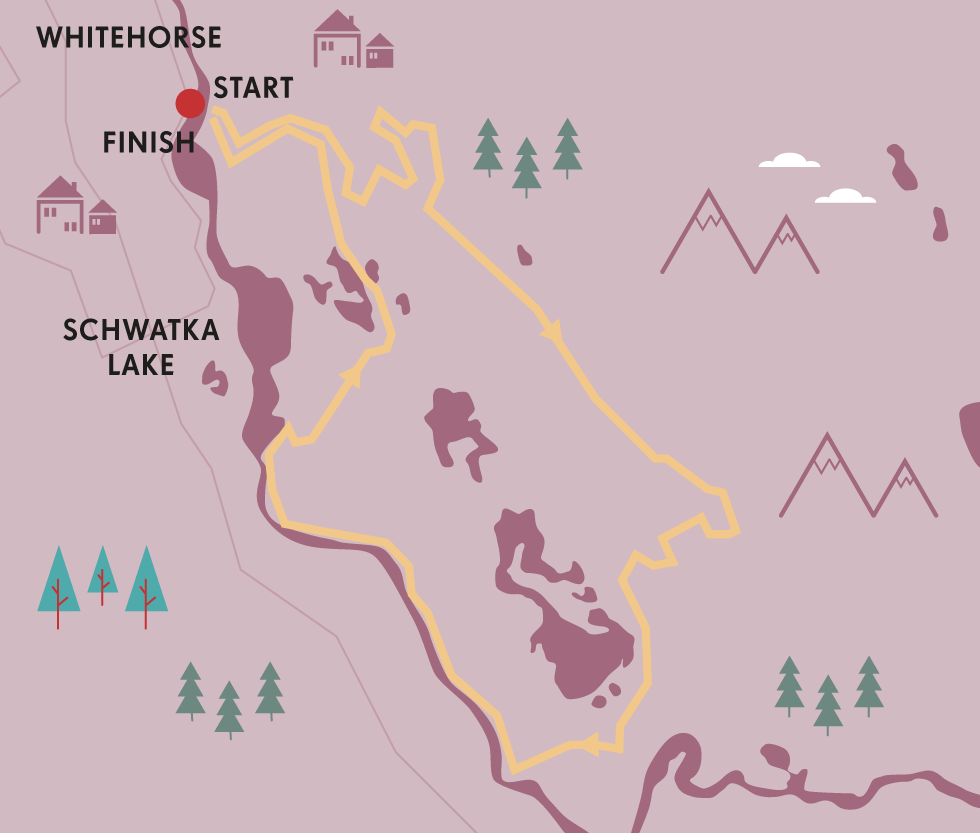
Studying a guide to Whitehorse’s mountain-bike tracks is a like eyeballing a plate of spaghetti dished up by an excessively flamboyant and generous chef. Some 435 miles (700km) of rideable trails have been mapped within the city limits of the Yukon Territory’s capital – 186 miles (300km) clicks of sensational singletrack, and 248.5 miles (400km) of delicious doubletrack and dirt roads.
I can’t think of another metropolis in the world that offers an off-road feast comparable to the bikers’ banquet served up here. But this tasty tangle of tracks also makes it difficult to decide where to start. Or finish. Or go in the middle. You could potentially pedal for days – weeks even – and not cycle over the same bit of dirt within this mind-blowing maze of interconnecting spruce-fringed paths.
It’s possible to splice several trails together into one epic continuous ride, instead of doing little circuits, but it definitely helps if you know the lay of the land – or roll with someone who does. Which is why I’m grateful to be following the flowing lines being etched in the earth in front of me by local guru, Sylvain Turcotte, owner of Whitehorse MTB base Boréale Explorers, and a pro trail hound.
We’re riding around a super scenic combination route on the outskirts of Whitehorse, on the Grey Mountain side of the mighty Yukon River – an emerald waterway that elbows right through this enigmatic territory, before crossing the border into Alaska.
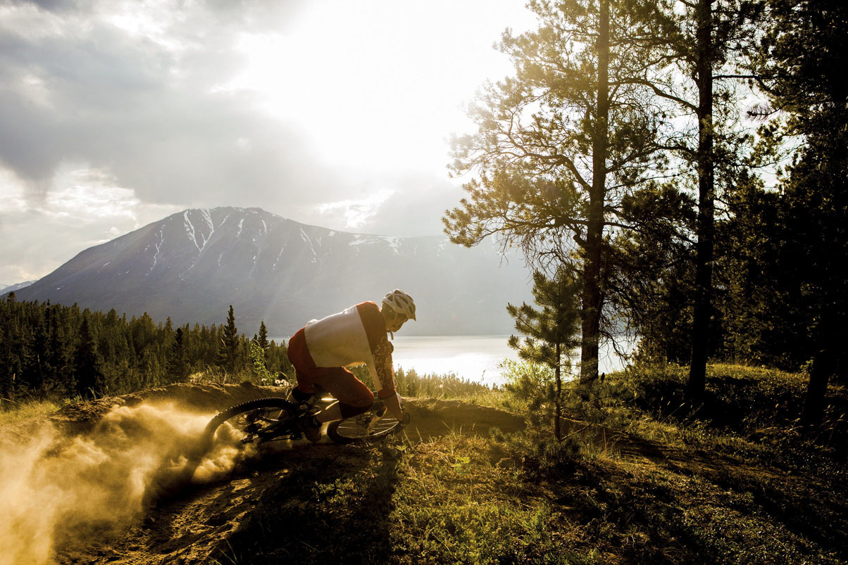
© Dan Barham
cornering in Carcross, south of Whitehorse
You can reach the trailheads directly from the CBD, with the wilderness beginning as soon as you leave the city streets, pass through Rotary Peace Park, cross the bridge and set off up Grey Mountain Rd. Our route – one of myriad options – begins with a gentle ascent to the Upper Riverdale Trail, which quickly delivers a cracking vista back across Whitehorse city and the great green Yukon.
Crossing Grey Mountain Rd, we follow the Yellow Brick Rd, a trail that leads (via several short connecting tracks) not to a wizard, but to the next best thing: the brilliant blue Boogaloo Trail system, which is every bit the ‘buffed out, fast-flowing and glorious piece of singletrack’ that David, another local guide, had promised it would be.
Although this isn’t like Vancouver’s notoriously gnarly North Shore scene, the trails do boast plenty of technical features. There are chicken runs alongside some of the scarier obstacles, in case you veer onto a track that’s beyond your skill level, but routes are clearly signed and graded according to International Mountain Bike Association (IMBA) standards: green circle routes are easy, blue square trails more challenging, black diamond tracks demand technical skill (or blind bravery) and double black diamond runs are only for highly experienced and/or pain-impervious riders.
CARCROSS
Canada’s newest mountain-bike mecca is in Carcross, home to the Tagish First Nation. Around Montana Mountain, a trail network of 46.5 miles (75km) – including 22 miles (35km) of singletrack – has been developed from old mining paths in a groundbreaking project involving local indigenous youth groups and cyclists. ‘Mountain Hero’, the star route, is an IMBA epic-rated trail featuring 12.5 miles (20km) of climbing and a 5-mile (8km) descent to Nares Lake.
“The Southern Tutchone – First Nation people of the Whitehorse region – used the banks of the Yukon as a trading route”
Other clues to how tricky a trail might be can be found in the extra colourful vernacular employed in the name – SFD (Straight Fucking Down) being a prime example of a track that delivers exactly what it swears it will.
Leaving Boogaloo behind we venture further up the flanks of Grey Mountain and tie together a bunch of blue and black tracks – including Payback, SFD, Girlfriend and Juicy – for a long, flowing (and occasionally eye-wateringly rapid) descent around Chadburn Lake to the start of the iconic Yukon River Trail.
This open and undulating trail traces the east bank of the Yukon River for 4 miles (6.6km), rolling spectacularly along the steep ridge and occasionally ducking and diving into the forest. The loose-dirt path isn’t overly technical, but it is narrow and demands full focus, because one lapse of concentration or ill-timed gaze at the lovely views might result in a high-speed tumble all the way into the freezing embrace of the river.
This path is steeped in history. For centuries before the arrival of Europeans, the Southern Tutchone – First Nation people of the Whitehorse region – used the banks of the Yukon as a hunting and trading route. And in the late 1890s, prospectors (including the author Jack London) with heads and hearts running hot with gold fever, rushed this way, in a desperate scramble to reach Dawson City and the Klondike to stake their claim. What they would have given for a sturdy dual-suspension steed I can only imagine.
The route rages on, clinging to cliffs and sidestepping bluffs, right through the historic ruins of an old boom town, Canyon City, an important stop-off during the 1898 Klondike Gold Rush – stampeders would stop here before nervously negotiating potentially lethal rapids just downstream.
It’s not a bad spot for riders to calm their own nerves before pedalling the precipitous Rim Trail, which tiptoes along the edge of Miles Canyon and ultimately leads down to the shores of Schwatka Lake, where glacial waters await those brave enough to make the plunge.
And then there’s a decision to be made. Head back to Whitehorse or explore more trails around the Hidden Lakes? The day is getting old, but that scarcely matters. It’s midsummer, a time when the Yukon lives up to its nickname as the land of the midnight sun.
Whitehorse occupies a position on the globe so far north that the sun barely sets for several weeks around the summer solstice, and the sky never gets properly dark. There’s even a 24-hour mountain-bike race here where using lights is against the rules. As Robert W Service, the bard of the Yukon, once observed: ‘There are strange things done in the midnight sun’.
We ride on towards the Hidden Lakes. To pass up the opportunity of finding more cycling gold in these hills really would be strange. PK
TOOLKIT
Start / End // Whitehorse
Distance // 31 miles (50km)
Tour // You can ride independently (free) or with a local operator such as Boréale Explorers (www.be-yukon.com), which provides good-quality bikes, expert guidance and yurt-based accommodation in the midst of the trails.
What to take // A decent dual-suspension mountain bike, along with a helmet, some armour and all the usual spares and tools. Carry bear spray (seriously) and insect repellent.
When to ride // Unless you have a fat bike (a mountain bike with supersized tyres) tracks are only rideable May to October. Check out June’s 24 Hours of Light MTB festival.
More info // See www.yukonbiking.ca. Printed waterproof maps can be purchased in Whitehorse’s two local bike shops, Cadence Cycle and Icycle Sport.
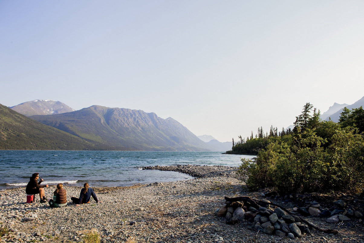
© Dan Barham
taking a break by the lake near Carcross, Yukon
- EPIC BIKE RIDES OF THE WORLD -
MORE LIKE THIS
MOUNTAIN BIKE TOWNS
FORT WILLIAM, SCOTLAND
At the epicentre of Lochaber, the self-proclaimed Outdoor Capital of the UK, Fort William is a mountain bikers’ trail town that hosts a highly popular stage of the annual Mountain Biking World Cup, but also offers pedalling punters a broad range of cross-country riding tracks. The Nevis Range has everything from gentle green-graded forest trails through to black-diamond rocky runs, and there are more at Lochaber MTB centre. Test yourself on the Witch’s World Champs, a red route entirely comprised of singletrack with over 270m of climbing, which was designed for the 2007 World Championships in Leanachan Forest, and also explore Laggan Wolftrax in nearby Strathmashie Forest.
Start/End // The Witch’s Car Park
Distance // 5 miles (8.5km)
More info // www.ridefortwilliam.co.uk
WHAKAREWAREWA TRAIL, ROTORUA, NEW ZEALAND
The Whakarewarewa trail network on the southern outskirts of Rotorua on New Zealand’s North Island offers 81 miles (130km) of super sweet singletrack, with trails for all abilities snaking through a fantastic forest of Californian redwoods and New Zealand natives, including a killer loop formed by linking Tokorangi, Katore, Gunna Gotta, Paddy’s Run, Tickler, Be Rude Not 2, Pig and Exit tracks. This trail town extraordinaire has hosted every international MTB event going, from the UCI Mountain Bike & Trials Championships (held on Mt Ngongotaha in 2006) to the Crankworx Mountain Bike Festival and the opening round of the Enduro World Series (both in 2015). Since 2013 it has staged the annual 10-day Rotorua Bike Festival each February.
Start/End // Nursery Rd (or Long Mile Rd car park)
Distance // 9 miles (15km)
More info // www.riderotorua.com or www.skyline.co.nz
ALICE SPRINGS, AUSTRALIA
There are world-class mountain-biking parks scattered all across Australia, but arguably the best ‘trail town’ in the big burnt country is found slap bang in the Red Centre – in a town called Alice. From the middle of rusty, dusty downtown Alice Springs, you can ride straight into the magical MacDonnell Ranges, where hundreds of kilometres of truly terrific singletrack threads through the ochre peaks, around the red bluffs and out into the desert. The terrain screams iconic Australian outback, and this is fast becoming the Southern Hemisphere’s answer to Moab. From the trail centre recently opened at Telegraph Station, you can explore an excellent figure-of-8 route by combining Apwelantye, Arrwe and Ilentye trails. The centre rents bikes and provides guidance, proper signage appears at trailheads and junctions, and professional trail builders are still adding to the network of tracks already established by highly active local riders.
Start/End // Telegraph Station trailhead
Distance // 14 miles (23km)
More info // www.outbackcycling.com/alice-springs/mountain-biking; www.centralaustralianroughriders.asn.au

© Mead Norton / Stringer | Getty Images
Riding high over Rotorua, New Zealand
- EPIC BIKE RIDES OF THE WORLD -

THE MINUTEMAN BIKEWAY
Play Paul Revere on a ride from Boston’s northern outskirts to Lexington – scene of the first battle of America’s Revolutionary War – along the Minuteman Bikeway.

It’s not every day you come face to face with a national hero. But in suburban Massachusetts I eyeballed two of them, just a hop and a skip apart. Or, more accurately a push and a pedal – because cycling’s the way to do it.
There’s a clue to the heritage of my route in the name. The Minuteman Bikeway snakes 11 miles (18km) between the outskirts of Boston and a disused railroad depot at Bedford, tracing – roughly speaking – the route taken by Paul Revere on his famous night ride of 18 April 1775. But though patriotically named for the best-trained colonial militia – ready at a moment’s notice to take arms against oppressive British redcoats – this isn’t a Disney-fied tourist route, but a popular commuter cycle path. It’s also the perfect way to access some of the most important historic sites in the area during a Boston city break, so I hired a bike and grabbed a map for the relaxing half-day ride.
Having braved the city’s morning rush-hour, at Boston Common I joined the blissfully traffic-free cycle path west along the Charles River, the shouts of coxes berating college rowing crews drifting across the water. Through Harvard Sq and on to Belmont I zigzagged through quiet back roads and among the beautifully restored wetlands of the Alewife Brook Reservation to northern Cambridge.
A granite column marking the bikeway’s terminus is etched with alewifes, reflecting this spot’s traditional name. I felt a pang of disappointment: I’d pictured an exuberant tavern-keeper’s partner, sloshing foaming flagons. But no: an alewife – pronounced more like ‘all-wuff’ – is a tiny fish found in the nearby Mystic River. No matter. The road to independence beckoned.
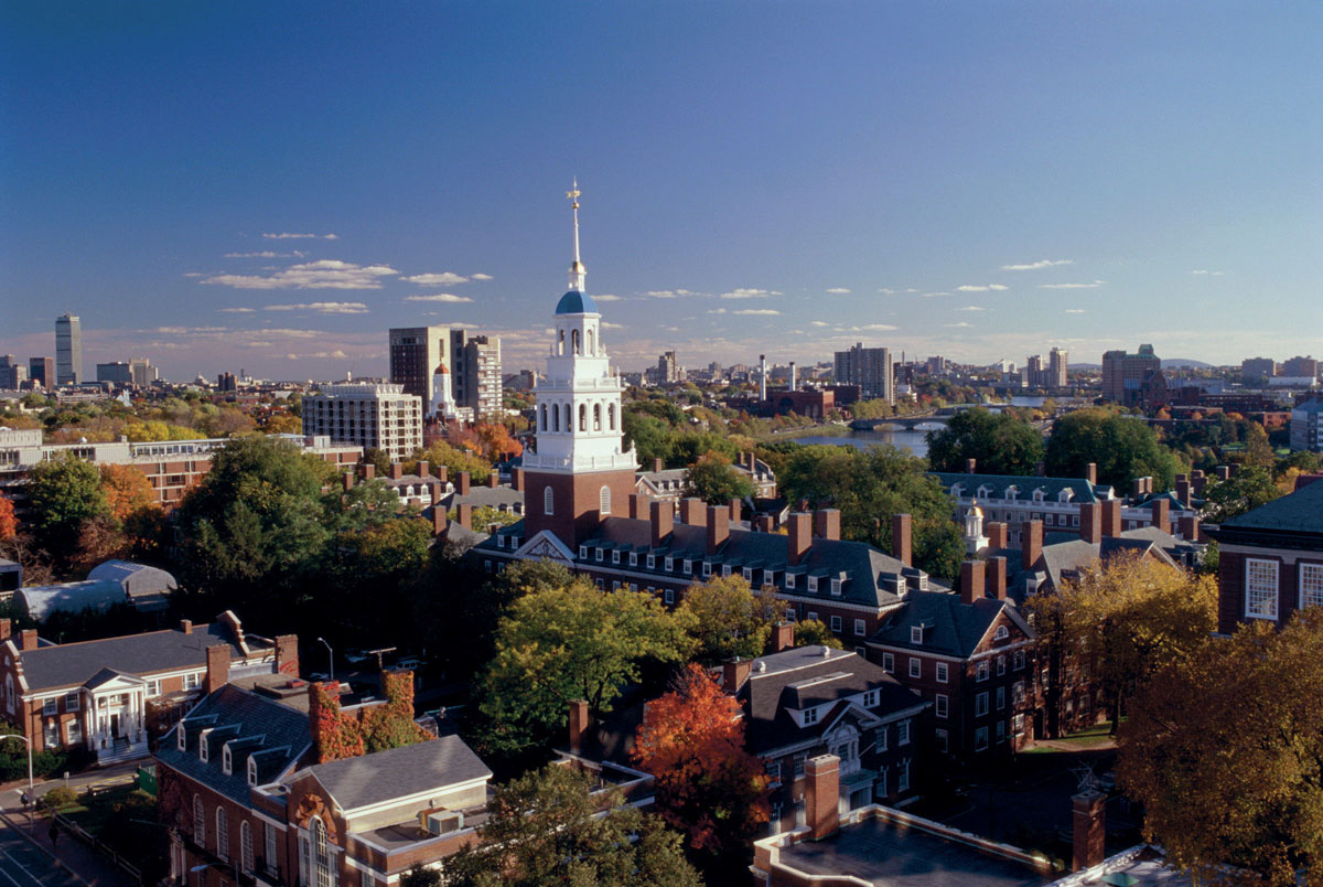
© Steve Dunwell | Getty Images
Harvard University in Cambridge, Massachusetts
In fact, the bikeway’s genesis was revolutionary in more ways than one. This tarmac ribbon replaced the former Boston–Lexington railroad; after it was mothballed in the late 1970s, local activists battled to transform the route into today’s cycle trail, opened in 1992. The Minuteman project was at the vanguard of the Rails-to-Trails Conservancy, a movement formally created in 1986 that backs communities across the US working to convert disused lines.
As I trundled past the monolithic milepost I thought of Revere and his nocturnal mission to warn Lexington and Concord’s rebel militia of the arrival of the British. And almost immediately a reminder of another, less well-known episode of that crucial night appeared at Spy Pond. In the 19th century, before modern refrigeration, ice was harvested commercially here, and today it’s a popular ice-skating venue. But on 19 April 1775 it was just a country lake, where Mother Batherwick was out gathering dandelions – or so a signboard here proclaims – when she spotted British soldiers retreating from Lexington. Far from fleeing, the bumptious old woman took them prisoner – quite how, the board doesn’t say. But among the clapboard houses and swaying trees shedding their autumn foliage, it added fascinating detail to my burgeoning picture of that momentous day.
Just a couple more minutes’ pedalling brought me to Arlington and the steely – or, rather, bronze-y – gaze of Hero Number One: Uncle Sam. Yes, the Uncle Sam, or so his hometown claims: Samuel Wilson, a merchant born here in Arlington, won renown supplying the US army during another war against the British in 1812. His statue doesn’t look much like the goateed fellow on the recruitment posters – but then it’s debatable whether he truly was the inspiration for the national figurehead.
WHERE DID WAR REALLY START?
Ralph Waldo Emerson claimed the shot signalling the start of America’s Revolutionary War was fired at the North Bridge in Concord. Residents of Lexington, six miles (9.5km) east, counter it was earlier, on their Battle Green, when militia briefly fought British regulars. Consider both sides: cycle to Concord along the unsealed Battle Road Trail from Lexington (or the Reformatory Branch Trail from Bedford), or catch the Liberty Ride trolleybus.
I doffed my bike helmet respectfully, just in case, and scooted onwards, past the brown timber walls of the Old Schwamb Mill – the country’s oldest continuously operating mill site, where wood has been shaped since around 1650 – and on to Arlington’s Great Meadows, roughly halfway along the trail. Pausing in the shade of a tree bedecked with flaming fall hues, I listened to a cricket chirping its final song of summer. Boston – and thoughts of war – seemed a long way distant.
The bikeways skirts around the centre of Lexington, and I decided to save that treat for later, pushing on for another half hour to Bedford. At the official end of the Minuteman sits gleaming railcar No 6211, a restored 1950s relic of the Boston and Maine Railroad and a reminder of the web of railway lines that once radiated out from Boston. Today most are silent – except, on some at least, for the whirr of pedals and bike chains.
Content to have completed the trail, I returned to Lexington to delve a little more into the events of 1775. For a spot with such a momentous historic legacy, Lexington is a pleasantly understated town. I scooted past vintage houses studding its wide streets, spotting the Buckman Tavern, mustering point of the militia on that fateful April morning, and the 1698 Hancock-Clarke Parsonage, where Revere warned Samuel Adams of the approaching British regulars.
At Battle Green, site of the fateful skirmish, I stood in the shadow of Hero Number Two: Captain John Parker, tall on his rocky plinth, clasping his rifle ready to defend his hometown. It was Parker who led the local militia in their stand, losing his cousin and seven other rebels to redcoat arms in the first battle of the American Revolutionary War.
There’s something apt about arriving at Lexington, like Revere, on a saddle rather than in a car or bus seat. It might not be the most dramatic ride, nor the most challenging, but the Minuteman provides a journey into the past – an exhilarating way to explore the history of Massachusetts’ insurrectionary forebears. PB
TOOLKIT
Start // Alewife Station, North Cambridge, Massachusetts
End // Bedford Depot Park/South St, Massachusetts
Distance // 10.5 miles (17km)
Getting there // Alewife ‘T’ Station is on the red subway line. www.mbta.com
Bike hire // Urban Adventours (www.urbanadventours.com) hires hybrid bikes from US$40 for 24 hours. Lexington’s Ride Studio Cafe (www.ridestudiocafe.com) provides bikes, parts, advice and great coffee.
Where to stay // The Inn at Hastings Park (www.innathastingspark.com) is a boutique hotel with terrific food close to Lexington’s Battle Green.
When to ride // The trail is open year round; it’s snow-ploughed in winters.
More information // www.minutemanbikeway.org.
© Danita Delimont | Getty Images
a reenactment with Redcoats in Lexington
- EPIC BIKE RIDES OF THE WORLD -
MORE LIKE THIS
RAIL TRAILS
CICLABILE DELLE DOLOMITI, ITALY
Scenery doesn’t get much more spectacular than the limestone ranges of the Dolomites in northeast Italy. This largely traffic-free bike path, formerly known as the ‘Long Way of the Dolomites’, follows a railway line through the provinces of Belluno and Bolzano that was built during WW1 and many of the original stations, tunnels and bridges remain. The bike path also runs beside the Boite River and through such pretty alpine towns such as Vodo, Venas and Valle at the foot of the peaks of Pelmo and Antelao. Trains to Venice and Padua depart from the finish town of Calalzo di Cadore.
Start // Dobbiaco
End // Calalzo di Cadore
Distance // 37 miles (60km)
ROUTE OF THE HIAWATHA, USA
Mind the bears! In winter this 15 mile (24km) rail trail closes because hibernating bears hole up in the tunnels. With 10 long tunnels, including the 1.6 mile (2.5km) Taft Tunnel, this family-friendly rail trail through the Bitterroot Mountains between Idaho and Montana is the perfect habitat for the cantankerous mammals. The Route of the Hiawatha is one of America’s most scenic and historic rail trails, and features not only tunnels, but seven trestle bridges along its downhill route from the East Portal trailhead. Pair this excursion with the 73-mile (117km) rail trail the Coeur d’Alenes, which follows the route of the Union Pacific railroad across northern Idaho from Mullan, a mining town on the mountainous Montana border to Plummer near the Washington border.
Start // Shuttles operate from the Lookout Pass Ski Area
End // The Coeur d’Alenes concludes at Plummer
Distance // 88 miles (142km)
More info // www.ridethehiawatha.com; www.friendsofcdatrails.org
RATTLER & RIESLING TRAIL, AUSTRALIA
The Clare Valley in South Australia is the backdrop for these rail trails and its Riesling wines – arguably the best in the world – your reward at the end of a day in the saddle. The Rattler Rail Trail (named after the trains that plied the Spalding line that it follows) connects Riverton and Auburn, where it meets the Riesling Trail. Once you’ve made it to Auburn (and neither of these trails are in the slightest bit challenging), the quaffing can begin. Clare Valley is home to around 30 cellar doors, with crisp, acidic Riesling the speciality but the local cool-climate Shiraz is also very good. Some of the wineries are on the route of the rail trail but many are only a short detour down shady roads. The Riesling Trail starts in Auburn and continues to the town of Clare.
Start/End // Riverton and Clare, via Auburn
Distance // The Rattler is 12 miles (19km), the Riesling Trail is 22 miles (35km)
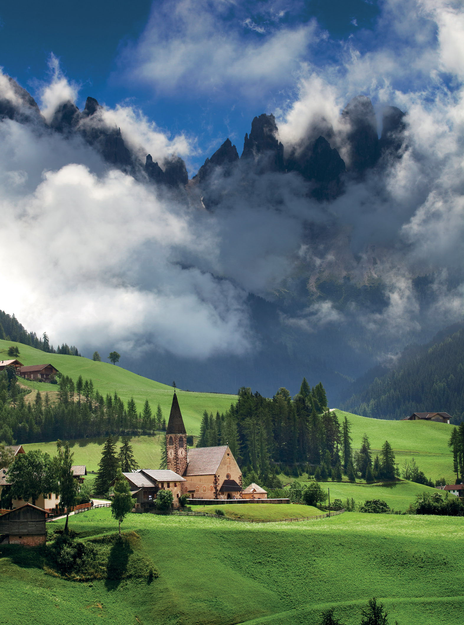
© Matt Munro
Dolomites scenery in the Val di Funes in Bolzano province
- EPIC BIKE RIDES OF THE WORLD -
BUENOS AIRES’ BIKE PATHS
The chaos, colour and character of the Argentinian capital’s barrios is best viewed from two wheels, as you ride through its past to its present.
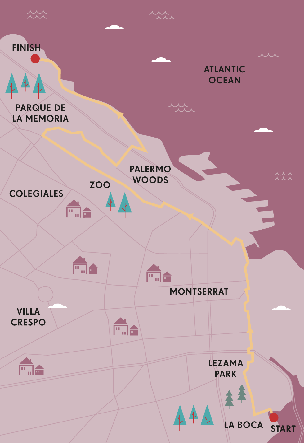
From Jorge Luis Borges’ short stories of knife fighters and tango dancers who owned the street corners of the old city, to the elegant tree-lined avenues that hark back to the city’s golden age, street life is central to the Buenos Aires’ lore and legend.
It’s no different today – sidewalk cafes where the city’s handsome citizens while away hours, vendors selling everything from feather dusters to hammocks, and the city’s famous dog walkers wrangling hounds of every shapes and size: it all happens on the street. You don’t even need to go inside a museum to see some of the city’s best art – a thriving street art scene means you can enjoy contemporary masterpieces without ever dismounting your bike.
I’d lived in Buenos Aires before the bike paths were laid, and was used to traveling by taxi, bus or on foot. But when I returned on a recent visit I was delighted to find a new way to enjoy the city, cycling swiftly and safely through the cobbled streets of Palermo, sneezing at the plane trees that drop their fine fluff during the springtime, and admiring the purple blooms of jacaranda along Avenida del Libertador.
My favourite ride takes you from La Boca to Parque de la Memoria, an easy 5½ miles (9km) if you go direct, but you’ll want to meander through the city’s cycleway network, taking in the sights and sounds of several barrios (neighbourhoods), each one very distinct.

© Philip Lee Harvey
an avenue of jacaranda trees in Buenos Aires
La Boca is the logical place to start, because while it may not be the spot where the city was first founded by the Spanish (that honour belongs to Parque Lezama, which you’ll ride past soon enough), it represents Argentina’s birthplace as a polyglot, immigrant nation. It’s here that the hundreds and thousands of migrants poured off their ships and into the boarding houses and poor neighbourhoods of the city’s south. ‘The history of Buenos Aires is written in its telephone directory,’ penned English writer Bruce Chatwin, and more than half those names are Italian, mixed up with German, Welsh, Irish, French and Spanish.
The backbone of your ride is El Bajo – the wide multi-laned thoroughfares of Paseo Colón and Avenidas Libertador and Figueroa Alcorta. The porteños (locals or people of the port) refer to it as El Bajo (meaning ‘low’) because it’s the low-lying land sloping down towards what was once the banks of the wide brown waters of the Río de la Plata. The city has turned its back on the river, blocking the view with high-rises, and you’ll not catch a glimpse of the water at this end of town unless you choose a detour through the swanky remodeled docklands of Puerto Madero or take a ride through the leafy Parque Ecológico.
From La Boca, the next neighbourhood heading northwards is San Telmo. Once the home of the well-heeled, a yellow-fever epidemic saw them abandon their now-crumbling mansions for the northern end of town. On Sundays, San Telmo’s Calle Defensa is taken over by street stalls selling handicrafts and bohemian fashion. There’s usually a grungy young tango band or two, while Plaza Dorrego hosts an afternoon open air milonga (tango party). For a bit of literary history, take a ride up Calle México to the old Biblioteca Nacional, the National Library where Borges was director for years, and wrote many of his most celebrated stories.
SHOPPING IN THE MARKETS
You can even shop on two wheels in Buenos Aires, especially if you hit the city’s famous markets. There’s San Telmo on Sundays and Plaza Francia, Recoleta from Friday to Sunday. But the loveliest is the Mercado de las Pulgas – the Flea Market – on Avenida Dorrego and Avenida Álvarez Thomas, where you’ll find everything from priceless antiques to kitsch urban trash. It’s open from Tuesday to Sunday.
“A thriving street art scene means you can enjoy contemporary masterpieces without dismounting your bike”
Just a little further along Defensa, and you’ll hit the Casa Rosada, or Pink House – Argentina’s seat of government. Famous as the place from which Eva Perón made her stirring, strident speeches, it looks over Plaza de Mayo, the political heart of the country, which is usually filled with protestors of various stripes. Up Avenida de Mayo you can get a feel for the city’s more opulent past, with the ornate facades of once-elegant buildings now dark with soot.
Back on the Bajo, you’ll head further north to Recoleta, and then on to Palermo. It’s worth ducking up into the heart of each barrio and along its smaller streets. You’ll find plenty of bars and restaurants with outdoor tables where you can eat while keeping an eye on your bike – a good idea in this city.
The end of your ride takes you along the beautiful Avenida del Libertador, through the Palermo Woods with their artificial lakes and beautiful rose garden. The place to rest after cycling this wonderful city is at one of its newest parks, Parque de la Memoria. Here you’ll finally come face to face with the river; its dulce de leche waters lap against this quiet green space, dotted with sculptures. A wall bears the names of the thousands of Argentines who disappeared during its Dirty War, when the military government attempted to cleanse society of any political dissidents by murdering them or driving them into exile. It’s a solemn but beautiful spot, and its sadness doesn’t inhibit the young lovers who go there to smooch between classes at the nearby university. Irrepressible Argentines.
Any time of day is a good time to cycle, as this is a city that truly never sleeps. On a recent evening ride, I stopped for a refreshment on Libertador to find an elderly woman and her pooch rendezvousing with her middle-aged daughters and their own canine companions for coffee and cake. It was midnight, and we shared a joke as joggers padded past and the cars racing by helped light the summer evening. Portenos love their city, and know how to enjoy its beauty and its chaos. SG
TOOLKIT
Start // La Boca
End // Parque de la Memoria Distance // 5½ miles (9km), but detours recommended
Getting there // International travellers arrive at Ministro Pistarini Airport at Ezeiza. Flights from nearby countries land at Palermo’s convenient Jorge Newbery Airport.
Bike hire // Some hotels have free bikes for guests: try Casasur Bellini in Palermo. Biking Buenos Aires (www.bikingbuenosaires.com) rents bikes by the hour and day.
Bike share // See www.turismo.buenosaires.gob.ar/en/article/cycling-ba for a downloadable map.
Tours // Biking Buenos Aires (www.bikingbuenosaires.com) has a good selection, including one dedicated to street art.
When to ride // Spring, from mid-October to December.
Bike purchases/repairs // Try Canaglia Bicicletas.

© Krzysztof Dydynski | Getty Images
street scene from San Telmo
- EPIC BIKE RIDES OF THE WORLD -
MORE LIKE THIS
CITY RIDES
BARCELONA, SPAIN
By fringing its medieval streets with a modern maze of bike lanes (107 miles/172km of them), Barcelona has evolved into a cycling city in the last decade. Its ‘Bicing’ scheme is aimed at inhabitants, but bike-hire facilities and cycle-tour experiences are ubiquitous. Take a spin to Montjuïc Castle, a 17th-century hilltop fortress and former prison with spectacular city and sea views, or do an urban loop from Plaça Catalunya, through the Barri Gòtic, past Santa Maria del Mar to Ciutadella Park. Ride up passeigs de Lluís Companys and de Sant Joan, under the Arc de Triomf and swing a right to the Sagrada Família at Gran Via, before returning via La Casa Batlló and La Rambla.
Start/End // Plaça Catalunya
Distance // 5 miles (9km)
MONTREAL, CANADA
With its savagely hilly topographical profile and harsh seasonal weather conditions, Montreal has been described as an unlikely cycling city, yet that’s exactly what it has become, with well over 373 miles (600km) of bike trails slithering around town – almost 155 miles (250km) of them entirely separate to road traffic – and more than 5000 public-use bikes available for hire. Each summer, some 30,000 people rock up in Jeanne-Mance Park to take part in the annual Tour de l’Île de Montréal, a road riding challenge that has several distance options (the 15-mile/25km or 31-mile/50km classic, and the 40-mile/65km or 62-mile/100km Découverte). The routes – which roll around the Island of Montreal and span the mighty St Lawrence River across Jacques Cartier and Champlain bridges, over Île Sainte Hélène and through Parc Jean-Drapeau, to explore Longueuil and Parc Michel-Chartrand before returning to the start – can be ridden at any time, but roads are closed to motorised traffic during the event.
Start // Parc Ave
End // Jeanne-Mance Park
Distance // Ranges from 15 miles to 62 miles (25km–100km)
AMSTERDAM, THE NETHERLANDS
Bikes form part of the fabric of Amsterdam, possibly the planet’s most cycle-friendly capital. Each day, 400,000 riders trundle along 249 miles (400km) of dedicated cycle paths, which wend around every corner and canal in this 17th-century city. Unsurprisingly, the city and its surrounds are as flat as a Dutch pancake, so cycling is easy. Bikes in the Dam are typically low-slung cruising machines, ridden with a jaunty upright gait. Pedal around the city centre, taking in the main sights, or loop out along the banks of the River Amstel to Ouderkerk aan de Amstel, before riding to Abcoude and the fortress town of Weesp, via the Bullewijk, Waver, Winkel and Gein rivers. Then trace the River Vecht to Castle Muiderslot, passing through Diemerpark, back to the centre.
Start/End // Amsterdam Centraal train station
Distance // 28 miles (46km)

© Sarah Coghill
ride the bridges and canalpaths of Amsterdam
- EPIC BIKE RIDES OF THE WORLD -

THE COVERED BRIDGES OF VERMONT
Drink in the flaming fall foliage – and gallons of gloopy maple syrup – on a cycling circuit between a handful of the US Northeast’s most winsome towns.
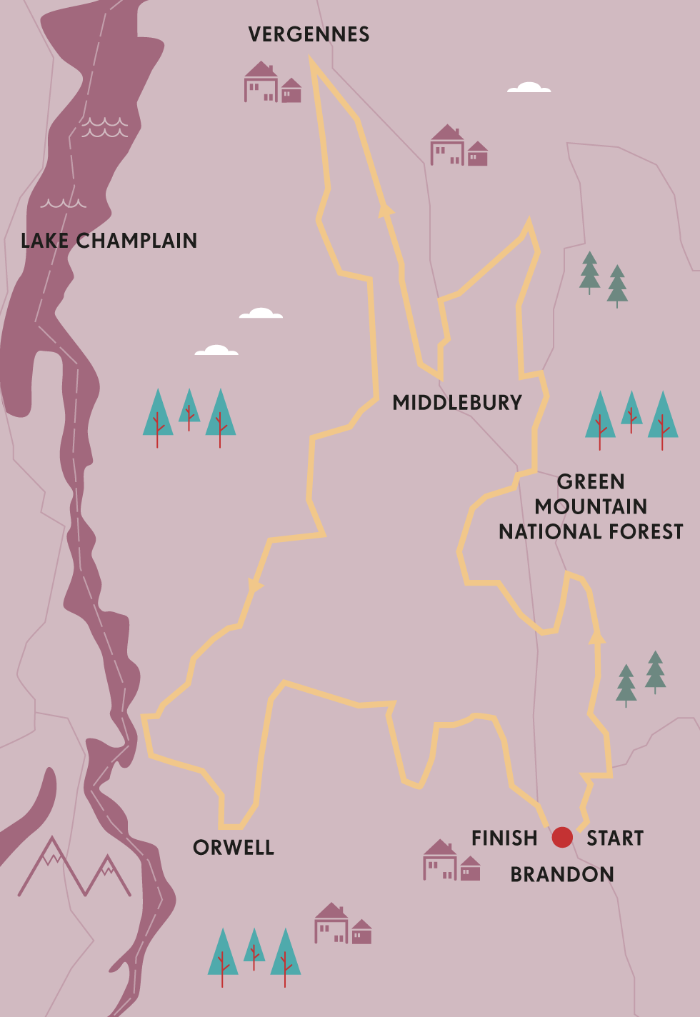
The flaming fall foliage in Vermont is a knock-out. Quite literally – it left me sparked out, flat on my back and gasping for breath.
Cycling along the leafy back lanes of Addison County, I was savouring the gentle burn in my calves on the short ascents, then the whispered kiss of the September breeze on my face as I freewheeled down. Alternately puffing and purring, I was happily drinking in the ubiquitous woodscapes of crimson and incandescent amber when suddenly it seemed I’d been drinking a little too deeply. Concentration broken by the vistas while pelting joyfully downhill, I turned a corner to be faced with an unexpected T-junction. On jammed the brakes. The bike stopped dead. I didn’t – and flew over the handlebars, with just time to think: so this is what they mean by fall in New England…
Fortunately, both the bike and I survived pretty much unscathed – only my reverie had been punctured. Dusting off my bike, I vowed to focus more on the road and less on the scenery.
That’s easier said than done in these parts. Riding through central Vermont in autumn is like cycling through a succession of mesmerising screensavers. Forested hillsides glow with traffic-light hues, red and amber and vibrant green. Red Dutch-gabled barns rise from cornfields, wooden covered bridges span serene waterways and pumpkins are piled at roadsides. It’s idealised New England turned up to 11 – and biking heaven.

© Larry Gerbrandt | Getty Images
Lake Champlain
That comical tumble came just a couple of hours into a 100-mile (161km) triangular ride between three of the most charming burgs in the Champlain Valley, midway from Massachusetts to Montreal. This broad, undulating dale, bounded by the Green Mountains to the east and New York State’s Adirondacks to the west, is becoming renowned for inn-to-inn cycling tours, as is Vermont in general – with good reason.
For starters, it’s predominantly rural – only Wyoming has a smaller population than Vermont, and the state’s tallest building is only 11 storeys – and most of its roads are wide, quiet and eminently bike-friendly. The food’s terrific, all artisan this and that, craft beers and, well, oceans of maple syrup. And it’s breathtakingly beautiful.
My three-day jaunt began in Brandon, an artsy little settlement of clapboard houses where wicker chairs rock on shady verandahs. I’d timed my trip well. A handful of chilly nights had kickstarted the leaf-peeping season, so when I saddled up on a crisp September morning, the hilltops were already smouldering with fall colours.
FROM SAP TO SYRUP
Vermont produces more maple syrup than any other US state. Native American peoples taught settlers how to tap maple trunks in late winter (late February/early March) to collect the sap that oozes out as it rises in the morning and falls at night. To make syrup, they’d throw hot rocks into hollowed-out logs filled with sap; today, wood-fired evaporators are used. Forty gallons of sap produce just one gallon of syrup.
I tootled languidly along Park St and out past traditional farmsteads, glancing at the map to confirm my deliberately tortuous path. The plan was to pedal about four hours each day, covering 30 or 40 miles (48 to 64km) – but the blue line marking my route staggered across the page like a drunken spider, partly to avoid busy roads, partly to take in the most scenic patches.
A speedy pace was impossible anyway, because photo calls came thick and fast. I’d no sooner pack away the camera after one viewpoint than another materialised. First came the Falls of Lana, cascading 20m or so down the forested hillside. Then I skirted Lake Dunmore, wooden jetties jutting into placid waters. I might manage half a mile (800m), then be waylaid for ten minutes snapping grazing cows, hayfields and grain silos, or a barn-cum-antiques-store from which spilled toy cars, rusty signs, vintage hoes and whirligigs.
“I made a circuitous loop north, waylaid by whimsical road names demanding to be checked out”
It was mid-afternoon when I meandered into that night’s halt, Middlebury. The archetypal Vermont college town (Robert Frost lectured here), it’s blessed with white-spired churches, galleries, cafes and views over the burbling Otter River. I strolled along its brick-built main street and explored the Henry Sheldon Museum – ‘Bringing Vermont History to Life since 1882’ – and Vermont Folklife Center, showcasing local arts and crafts.
Next morning I fuelled up at the farmers market, its stalls laden with breads, cheeses, goat’s milk soap, and mountains of pumpkins the glowing ochre of late afternoon sun. Not to mention maple syrup. Bottles and jugs and flasks and flagons of maple syrup.
Loaded with portable calories, I pedalled back into the countryside en route to Shoreham, ten miles (16km) or so from Middlebury. But why go direct when you can enjoy the even-more-scenic route? Instead of heading directly west, I made a circuitous loop north via Vergennes, waylaid periodically by whimsical road names demanding to be checked out: Lemon Fair Rd, Bittersweet Falls Rd, Snake Mountain Rd. The latter traced a ridge providing panoramic views across the broad sweep of the Champlain Valley, Middlebury’s college and steeples rising from a sea of autumn colours to my left.
Bolstered by a breakfast mountain of blueberry pancakes in Shoreham, on my final morning I pedalled through a murky pea-souper and whizzed past the turn-off for Larrabee Pt, where a ferry crosses Lake Champlain to New York State and historic Fort Ticonderoga, then halted to investigate a roadside army of painted wooden creatures. In the adjacent barn I found the gallery of sculptor Norton Latourelle, who has carved a Noah’s ark of dogs, birds and rabbits – plus a curious long-necked beast labelled ‘Champ’.
‘He was first seen long before your Loch Ness Monster,’ Norton grinned. ‘The early French explorer Samuel de Champlain described him as a “20-ft serpent, thick as a barrel and with the head of a horse”.’
A tall tale, to be sure. But a search for a mysterious water creature might provide just the excuse to return and pedal some more of Vermont’s snaking, sensational byways. PB
TOOLKIT
Start/End // Brandon, Vermont
Distance // about 99 miles (160km) Brandon–Middlebury–(Vergennes)–Shoreham–Brandon
Getting there // Rutland Airport is 22 miles (35km) south of Brandon. Cape Air (www.capeair.com) flies from Boston Logan.
Tour // Inn to Inn (www.inntoinn.com) offers a four-night package, including half-board accommodation, maps, route notes, bike hire and baggage transfers.
Bike hire // Green Mountain Bikes (www.greenmountainbikes.com) rents bikes from U$30 per day; bikes can be delivered to inns.
When to ride // April to October. Foliage season is mid-September to mid-October, when rates rise and accommodation gets booked out.

© Naphat Photography | Getty Images
quiet roads and colourful leaves in Vermont
- EPIC BIKE RIDES OF THE WORLD -
MORE LIKE THIS
FALLING LEAVES RIDES
SONOMA COUNTY, USA
Sonoma County is where California’s velo and vino cultures collide in a happy claret splatter every autumn. For a classic Wine Country ride, leave the hub-town of Healdsburg, ride along Westside and turn right onto West Dry Creek Rd, an undulating 9-mile (14km) avenue that’s one of California’s most popular cycling roads. At Yoakim Bridge Rd, cross the valley to Dry Creek Rd, hang a left and climb Canyon Rd before enjoying the descent into Alexander Valley. Turn right, roll through Geyserville, cross Russian River and take Hwy 128, Red Winery and Pine Flat roads back towards Healdsburg, via Jimtown, with valley-hugging vineyards to the right and hills ablaze with autumnal colours on your left.
Start/End // Healdsburg
Distance // 32 miles (51km)
KYOTO, JAPAN
Less commercialised than spring’s pink-and-white eruption of cherry blossoms, the kaleidoscopic quality of Kyoto’s koyo (leaves) in autumn is equally sensational, especially when seen from the saddle. From mid-September, a crimson tide – the ‘koyo front’ – surges south across Japan from Hokkaido. A great place to see the fiery foliage at its reddest intensity is Tōfukuji Temple, which can be explored during an easy cycling loop from Kyoto station. Allow two hours (with stops) for this route, which wends west from the spaceship-like station along shared bike-pedestrian paths, then heads south along Higashinotoin-dori, before going west again to Toji Temple. From this impressive pagoda-topped World Heritage site, built in 796, pedal east, across the Kamo River, to explore the great Zen Tōfukuji temple. The amazing maple trees are best enjoyed from Tsutenkyo Bridge. From here, head north until you reach Meiji-jingū shrine, then go east and trace the river back to the centre.
Start/End // Kyoto City Hall
Distance // 7 miles (11km)
More info // www.cyclekyoto.com
TRANSYLVANIA, ROMANIA
Beyond the clichés of vampire counts and creepy castles, Romania offers intrepid travellers multiple mind-bending experiences, one of the best being an autumn-time cycling tour through Transylvania’s colour-infused Carpathian Mountains. This quiet corner of Europe boasts wonderful wildlife (including bears, lynx and wolves) and stunning landscapes punctuated by peaks and Saxon-era villages. In the heady embrace of the Făgă̆raş Mountains, try a two-wheeled traverse of the Transfăă̆̆gărăşan, a spin-out trip along a forest-flanked road, which flows around hairpin turns on its spectacular route from Bascov (near Piteşti) to Bâlea Lake. The Tour of Romania and the Sibiu Cycling Tour both pass this way, and horror fans can visit the village of Arefu and see Poenari Citadel, a 13th-century castle and one-time residence of Vlad the Impaler, inspiration for Bram Stoker’s Dracula.
Start // Bascov (near Piteşti)
End // Bâlea Lake
Distance // 73 miles (117km)

© Krzysztof Baranowski | Getty Images
Tofukuji temple in autumn hues
- EPIC BIKE RIDES OF THE WORLD -

VANCOUVER AND WHISTLER
Short, slippery and very steep: take on the world’s most adrenaline-charged mountain bike trails in the forests southwest of Canada’s British Columbia.
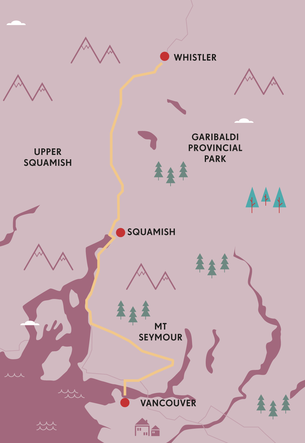
‘Stay low, and keep your arms bent,’ my tutor, Kevan, instructs me, as I edge towards a 2ft step-down. I hesitate, then, as my mountain-bike tyre rolls over the slippery root and into air, he tells me to extend my arms, pushing the bike down into the drop. ‘You have to absorb the terrain,’ he tells me. There’s no respite: the trail keeps snaking downward, around trees, over huge roots and rocks, at a relentlessly steep gradient. ‘Fear,’ Kevan says, ‘is a lack of confidence in your ability.’ Thanks, Kevan. And this is one of the easiest trails at Whistler Bike Park in British Columbia.
Fear is one reason I’ve come here: I want to acclimatise to the level of mountain bike riding in this southwest corner of Canada in the relatively controlled surroundings of Whistler Bike Park, 70 miles (113km) north of Vancouver. Every summer the ski resort’s lifts and gondolas are taken over by mountain bikers in body armour and full-face helmets, bearing burly full-suspension mountain bikes. Despite the protective kit, the injury rates among the summer mountain bikers are 10 times those of winter’s skiers and boarders.
Whistler was a bike park pioneer, and ski resorts across the world – from Canada to New Zealand and Europe – now resound to the thrum of knobbly tyres on downhill trails. Most offer specialist bikes and kit for hire, and also tuition or skills classes, so they’re good places to build your off-road repertoire, namely jumps, drops and near-vertical slopes.
Later in my day with Kevan, I pedal along wide logs, 4ft or 5ft off the ground. The next step is to ride ‘skinnies’, planks just 4in or 5in across. There’s little that is technically difficult about this, provided you have a sense of balance and can pedal in a straight line. They’re more a psychological leap than a physical one. Richie Schley, a veteran Canadian pro mountain biker agrees: ‘It’s a mind game,’ he explains to me. ‘None of us just got on a bike and did crazy stuff immediately. Put some logs on the ground and practise jumps. Learn the basics. Take baby steps.’
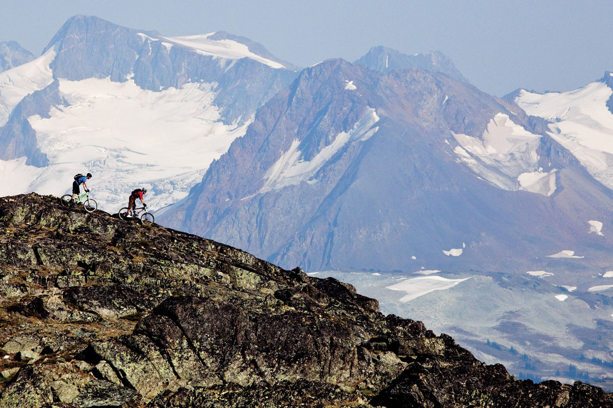
© Dan Barham
riding Whistler’s ridge
Ready or not, my time’s up. I head back down the Sea to Sky Hwy to Vancouver for my rendezvous with epic mountain biking, Vancouver-style.
‘Follow me,’ says my new guide, Johnny Smoke. We pedal past a chain-link fence to the top of a trail called CBC. It’s named after the Canadian Broadcasting Corporation’s TV mast at the top of Mt Seymour.
On first inspection, the North Shore of Vancouver is an affluent suburb on the north side of the Lions Gate Bridge, backed by three densely forested, 4000ft mountains: Cypress, Grouse (also known as Mt Fromme) and Seymour. But to mountain bikers, the North Shore is a legendary destination, one that begat a new style of mountain biking: freeriding – big air, big stunts, big risks.
THE TEST OF METAL
Between Vancouver and Whistler lies the logging town of Squamish, home to a cross-country mountain bike race called the Test of Metal. The event celebrated its 21st year in 2016, making it Canada’s most successful bike race. The challenge? It’s 42 miles (67km) long, but more than half of the route is technically demanding singletrack. It takes the winners around 2.5hrs to complete and the average human being up to 6 hours.
In the late 1980s, before full-suspension mountain bikes, local cyclists started riding down these mountains. In these steep, coastal forests of lofty hemlocks and cypresses they built their way over and around natural obstacles. Bogs were bridged, massive tree stumps breached by log ladders. Trail builders, most famously ‘Dangerous’ Dan Cowan and Todd ‘Digger’ Fiander, constructed ever more outrageous stunts. Video producers came to film local bikers riding higher and narrower ladders and plummeting off ever-larger drops. The trails’ names gave some clue of what to expect: Flying Circus was a terrifying network of five-inch wide ladders suspended 5m up in the trees.
Today there are about 125 mapped trails on the North Shore. Most tend not to be longer than half a mile (1km). But they are steep and contorted. It’s dark inside the old-growth forests and the Jurassic-sized roots and rocks are slippery; one misjudgement and you will slam into a clavicle-cracking tree.
These trails are the reason that the baseline standard of riding among North Shore locals is more than a step above the rest of the world and why this corner of Canada has produced so many of the world’s most skilful (or at least fearless) mountain bikers. Thanks to that group of pioneering riders, a quarter of a century ago, the next generation, and the one after that, grew up with an expanded sense of what was possible (or sensible). Skills – and a devil-may-care attitude – were passed down the line.
Come 5pm, and convoys of pick-ups and cars bearing mountain bikes often worth more than the vehicles, converge on the logging roads heading up Mt Seymour and Mt Fromme. Bikes are checked, armour strapped on and then, after a hard day at the office, it’s play time for Vancouver’s lawyers, dentists, shop workers and plumbers. Young or old, male or female, the North Shore doesn’t discriminate.
Neither does the CBC trail, where Johnny Smoke has brought me. It’s a 0.8 mile (1.25km) double-black diamond entree that links to a couple of classic North Shore trails, Pingu and Pangor. I begin gingerly. Most of the features are ground level, thankfully, and a lot of work has been done on the surface in recent years, so steep chutes are paved with stones. It twists and turns through a primeval Pacific rainforest. Every synapse in my brain is firing; the North Shore demands total concentration as we segue from trail to trail.
Then, with my arms aching from braking, I burst, wide-eyed, out of the forest and onto a suburban street. It will take a few more runs before I can follow Richie Schley’s best advice for riding the Shore: ‘Never hesitate.’ RB
TOOLKIT
Start // Whistler’s longest cross-country trail is Comfortably Numb, which starts from the Wedgemount parking lot.
End // Whistler Village
Distance // 12 miles (19km)
Getting there // Vancouver’s international airport receives flights from all over the world.
Where to stay // There are bike-friendly B&Bs on the North Shore. At Whistler, accommodation options include within the resort’s hotels and lodges, and private house rentals. It’s also possible to rent an RV in Vancouver and book a place at a campground (or during the summer, overnight for free in Parking Lots 4 and 5).
Terrain // Trails are graded like ski runs, from green (easy) to black and double black diamonds (hard). An intermediate trail here is more challenging than a hard (black) trail elsewhere.
More info // North Shore Mountain Bike Association (www.nsmba.ca); Whistler Bike Park (www.whistlerblackcomb.com); Test of Metal (www.testofmetal.com)
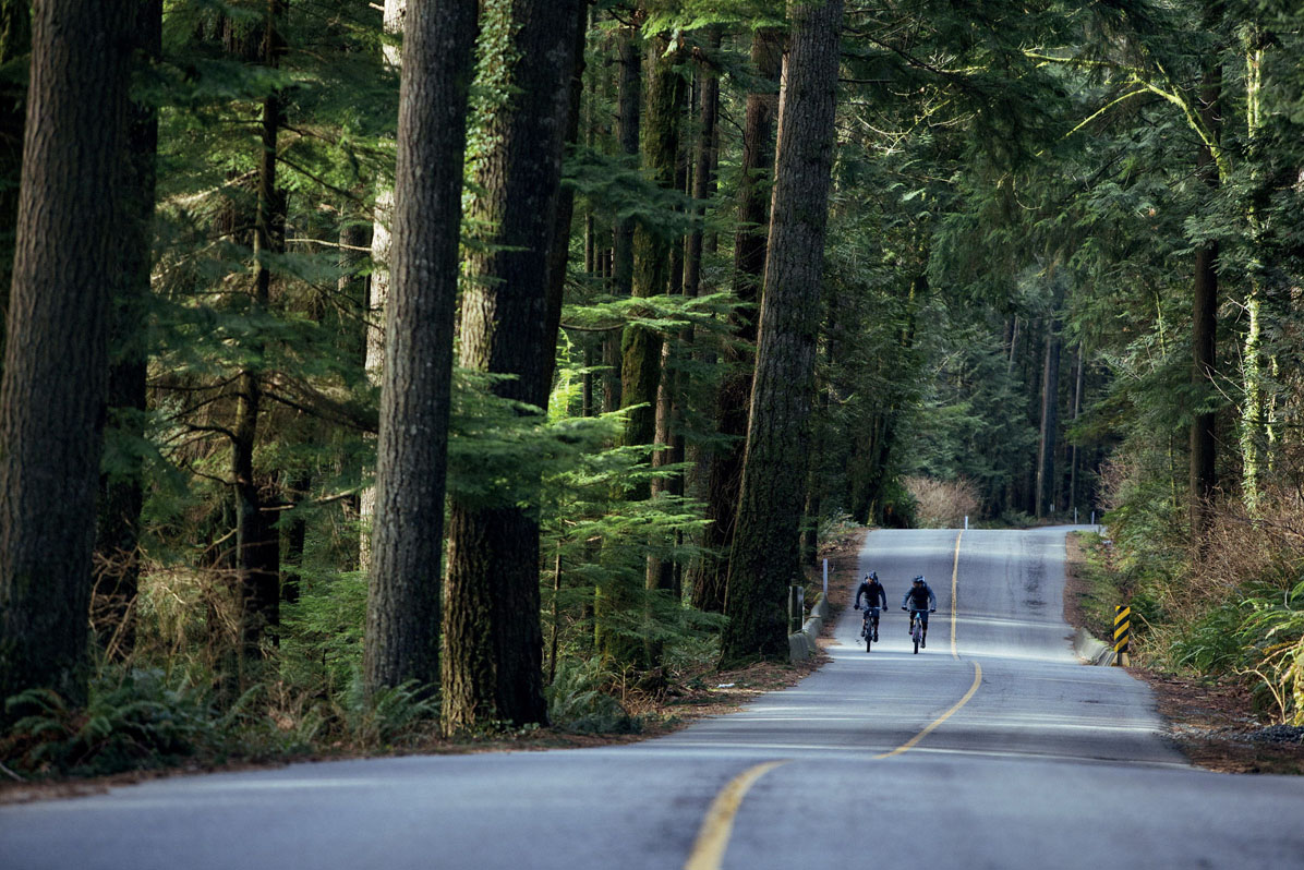
© Dan Barham
what goes down must go up – taking the road to the top of the North Shore mountains
- EPIC BIKE RIDES OF THE WORLD -
MORE LIKE THIS
MOUNTAIN BIKE PARKS
MAMMOTH BIKE PARK, CALIFORNIA
There’s an ever-growing number of bike parks knocking on Whistler’s door. In the Sierra Nevada, just beyond Yosemite National Park if you’re coming from San Francisco, Mammoth Mountain has 80 miles (129km) of purpose-built singletrack, accessed by the resort’s gondola. Trails range from long cross-country routes to steep and rough downhill tracks with berms and North Shore-style wooden features. The Pioneer Practice Loop around the Adventure Center is an easy trail for beginners and young riders, with instructions for each new feature. A huge range of intermediate terrain then opens up. The most advanced tracks have been used for National Championships. Just remember that you are at an altitude of 9000ft (giving 3000ft of vertical descent) and take it easy the first few days!
Start/End // Adventure Center, Main Lodge (where the gondola departs)
Distance // Longest trails are Off the Top, Beach Cruiser, and Downtown at 13.3 miles (21km); shortest trail is Richter at 0.3 mile (0.5km).
SAMOËNS, FRANCE
The French Alps have the highest concentration of bike trails accessed by ski lifts, with the supersized Portes du Soleil valley networking 13 resorts that all open for summer bikers; Les Gets and Morzine are among the most popular choices for foreign visitors. But if you want to get away from the crowds you don’t have to go far (though bike parks in Austria and Italy are also tempting), only to the neighbouring Vallée du Haut Giffre. More than 30 trails await, ranging from easy green routes around the mountain villages, intermediate blues through alpine pastures to steeper red and black-graded freeride tracks with jumps and berms. The trails tend to be more natural in style than those of the Portes du Soleil bike parks, crossing streams, and descending through forests. In 2015, Samoëns hosted a stage of the Enduro World Series.
Start // Tête de Saix (for many downhill trails), easier blue and red trails start lower down
End // Samoëns
Distance // The longest trail is 8 miles (13km), the shortest 0.6 miles (1km).
MT BULLER, AUSTRALIA
Bouncing wallabies, the scent of eucalyptus, and raucous birds: you know when you’re mountain biking in Australia. Arguably the country’s best bike park, though still dwarfed by resorts in the northern hemisphere, Mt Buller in central Victoria has enough purpose-built trails for a long weekend of dusty action. Four downhill tracks run from the resort hub, the longest at around 1.5 miles (2.5km). There’s a wider range of cross-country trails including the 25 mile (40 km) Australian Alpine Epic Trail that swoops across the Victorian High Country and requires more endurance than technical skill, with 2187m of descent (and 1245m of climbing). Stonefly, at 6 miles (9.5km), requires a bit more technical skill. Interestingly, the nearby town of Warburton is beginning to develop its own mountain bike trails, in a rainforest landscape of giant trees that has more in common with the Canadian North Shore.
Start/End // Mt Buller Village
Distance // 25 miles (40km) for the intermediate-graded Australian Alpine Epic

Courtesy of Mt Buller
miles of smiles at Mt Buller mountain bike park in Australia
- EPIC BIKE RIDES OF THE WORLD -

MANHATTAN CIRCUMNAVIGATION
An epic ride of America’s most famed city that leaves behind the crowds to reveal waterside glimpses of hidden New York.

The bicycle renaissance is thriving in New York, which is a surprisingly rewarding cycling city. Locals reading that sentence may be tempted – in a very New York kind of way – to roll their eyes and mutter something about the rest of the world being behind the times. New York is very bike friendly, from Central Park’s wide-open boulevards, which are closed to cars for much of daylight hours, to an ever-increasing network of bike lanes criss-crossing iconic landmarks, and exhilarating bridge crossings. Visitors to the city only take partial advantage of this. Few make their way any further than the far end of the Brooklyn Bridge, which is a shame. There is more fun to be had on two wheels by going further.
The jewel in the crown of New York cycling is the Manhattan Waterfront Greenway. This path snakes its way around almost the entirety of Manhattan Island, rolling for 31 glorious miles (50km). Looking at this ribbon of green on the map, I reasoned that this would be a suitable way to venture beyond the known city into places that tourists don’t stray. To do so, I needed to take to two wheels. I wanted to roll through unknown neighbourhoods, and explore the extremities of Manhattan. The interior, I figured, couldn’t be comprehensively mapped without becoming a resident, but the perimeter could be fairly efficiently circumnavigated. So I joined those hiring a bike, but set out with what I felt were grander ambitions.
As with any circular ride, there’s no ‘right’ way to go, but the prevailing view seems to be to head up the west side to the far north of the island, then back down the east side and complete the loop via the southern tip of the city.
My bike hire location was near Union Sq, meaning I crossed Chelsea and the Meatpacking District as the morning rush petered out, and I hit the Hudson bike path just south of the High Line. It was at this point that my perception of the city changed. Endless blocks of busy streets, stuffed with pedestrians and cars and honking taxis that made up the New York of my imagination was replaced by the broad Hudson River. A human scale emerged. It was more than a little strange to suddenly be away from the noise of the city, and instead be able to hear the grind of my wheels on the tarmac path, and the gentle yet firm calls to attention from runners overtaking pedestrians. These warnings became more shrill and direct as we approached the cruise terminal and scores of bemused new arrivals found they were blocking the recreational route of speeding locals. Here was an instant reminder that I was still where I thought I was, in boisterous New York.

© Sivan Askayo
crossing iconic Brooklyn Bridge
The Hudson Greenway, as this section is known, stretched on, and I found as I rode it that my sense of the topography of the city was shifting. Landmarks of northward progression – in particular Central Park – rolled past without notice. From the water I could tell I was leaving Midtown by the visible drop in the height of buildings I was riding parallel to. Fellow travellers on the route were thinning out too. Few tourists head out to lap the island, and on weekdays there aren’t many commuters outside of peak times. I even experienced feelings of solitude while moving around the world’s most famous city.
Fort Washington Park, marked by the Washington Bridge and the Little Red Lighthouse, felt like a signpost that I was leaving known areas behind and heading into unknown Manhattan. The far north of the island is stranger, and more remote from the familiar parts of Brooklyn and Queens.
Fort Tryon Park is home to one of the city’s most marvellous oddities: The Cloisters. This annex of the Metropolitan Museum of Art proved an ideal stop on my way, as much for the remarkable merging of five medieval abbeys into one whole, as for the works of art inside. Beyond here, shortly before Manhattan stops, cyclists dip inland through Inwood Hill, emerging on the east side of Manhattan for the first time on a path running along the Harlem Greenway. This was originally a horse-racing strip for weekending Manhattanites from which cyclists, ironically, were banned. Today a bike path follows it south until another detour takes you on a signed path through Harlem. This showed another side of the city. It was school graduation day and a happy, carefree atmosphere prevailed on the streets. Like so often on a bike, I pedalled through as an unnoticed observer.
BRIDGE RIDES
The bridges connecting Manhattan with the outer boroughs and New York are iconic landmarks on a circuit of the island. If you only ride one, the iconic wooden boardwalk on Brooklyn Bridge is it, but most can be cycled. The newest is also the oldest – the High Bridge connecting Harlem with the Bronx dates from 1848, when it was built as an aqueduct. Today it carries pedestrians and cyclists high above the Harlem River.
Beyond a small diversion around the United Nations complex between 54th and 37th Streets the Greenway then trundles happily down to Battery Park. South of the Williamsburg Bridge I started to pick up more cyclists, and couldn’t resist a few additional miles across the Manhattan Bridge, racing subway trains crossing the water, and returning via the busy but exhilarating Brooklyn Bridge bike and pedestrian path.
Once I’d cleared the crowds at Battery Park it was a short pull back up the Hudson to complete the loop. Bike safely returned, I had one final problem: New York is too exciting a city to relax and put your feet up. I briefly puzzled as to how to fill the rest of the day. The answer came in the form of the Staten Island Ferry, leading to another of the city’s boroughs. Which looked like a good place for a bike ride itself, another day. TH
“I found as I rode the Hudson Greenway that my sense of the topography of the city was shifting”
TOOLKIT
Start/End // The beauty of Manhattan Waterfront Greenway is you can start the loop wherever you want.
Distance // 31 miles (50km)
When to ride // Spring and autumn are best to avoid the city’s frigid winters and sticky summers, but if paths are clear and you’ve got suitable clothing it could be done anytime.
Bike hire // For quality hybrid- and road-bike rentals try Danny’s Cycles (www.dannyscycles.com; hybrid $10 per hour, road bike $15 per hour), with six locations around New York.
More info // The New York City Bike Map (www.nyc.gov/html/dot/html/bicyclists/bikemaps.shtml) has details on cycle routes across Manhattan and beyond. A print copy is most useful and can be picked up in bike shops and tourist offices.
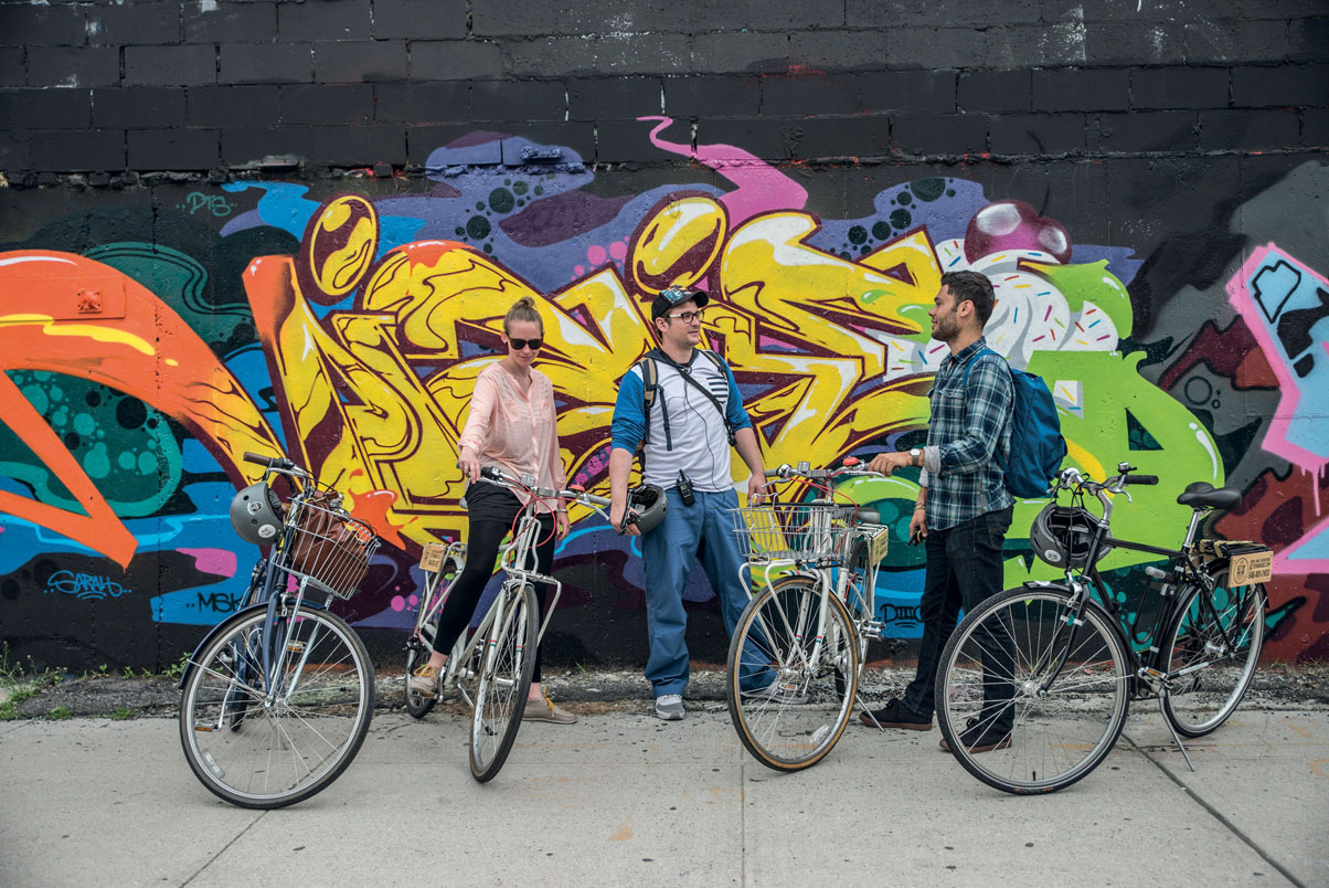
© Sivan Askayo
street scene in NYC
- EPIC BIKE RIDES OF THE WORLD -
MORE LIKE THIS
CITY RIDES
TOKYO
Japan’s magnificent sprawl may seem, on first glance, to be the antithesis of a cycling destination. With a little help it can be an equally surprising place to ride. Tokyo Great Cycling Tours’ six-hour Edo-Tokyo Culture Ride visits Ryōgoku sumo stadium, Ueno Park and concludes at the Imperial Palace. Book in advance. Another side of Japan’s cycling culture can be found at one of 47 velodromes around the country that are used for highly popular Keirin races. Keirin cycling is one of the few sporting events in Japan on which gambling is permitted, and entry to race meets is cheap. In Tokyo, visit the Keiokaku and Tachikawa velodromes for race meets.
Tour // Tokyo Great Cycling Tours (www.tokyocycling.jp) offer a variety of guided rides that are part cycling trip, part exploration of Tokyo’s well-known/less-heralded sights
MEXICO CITY
Mega-cities don’t seem to offer much promise for anyone considering cycling. They have vast populations, strained transport networks and a sense of controlled chaos. Mexico City, however, is emerging as an exception to the rule at the same time as its reputation as a city destination is growing. Here is a capital with millennia of history, reflected in dozens of museums and galleries, and the varied food and nightlife scene you’d expect when 21.2 million people come together. The major thoroughfares remain hard going, due to traffic and tarmac conditions, but, as with elsewhere in the world, bike tours exploring the city are popular with visitors and cover far more ground than you might on foot. With wheels you can explore some of the designated bike paths that criss-cross the city, including one that runs from Bosque de Chapultepec to the Centro Historico.
Bike hire // Rent bikes for free for up to three hours at locations in the centre, including from a booth by the Catedral Metropolitana. Ecobici (www.ecobici.df.gob.mx) is a commuter bike service that gives 45 minutes of free riding
When to ride // Sunday mornings, when several downtown streets are closed to traffic, opening up a 16-mile (26km) unbroken, car-free route
BROOKLYN-QUEENS GREENWAY
The 40-mile Brooklyn-Queens Greenway offers another grand day out, running from Little Bay Park in Queens to Coney Island, linking such attractions as New York Aquarium, Brooklyn Museum and Brooklyn Botanic Garden. By tackling the route over a day or two you can further discover the outer boroughs and also explore the many parks and dedicated bike routes that demonstrate the continued growth of cycling in New York. Best time to try it? Avoid the sticky heat of midsummer in New York and the snow of deep winter.
Start // Little Bay Park, Queens
End // Coney Island
Distance // 40 miles (64km)

© Aflo Co. Ltd. | Alamy
don’t miss watching a keirin race in a Tokyo veldrome