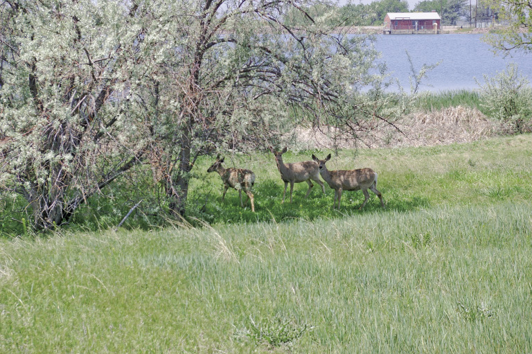
Mule deer browsing on the shore of Ladora Lake
1
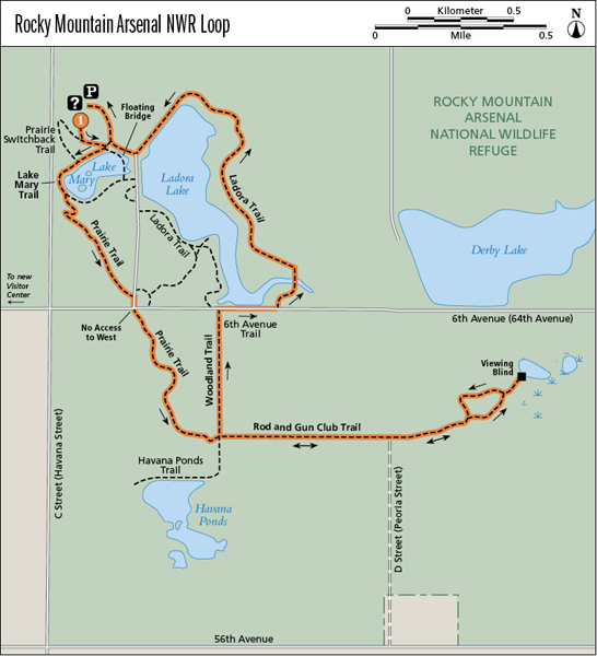
Rocky Mountain Arsenal National Wildlife Refuge Loop
Established by Congress in 1992, Rocky Mountain Arsenal National Wildlife Refuge (RMANWR) is a work in progress. Over the years the 1- to 2-mile-wide buffer around the old chemical weapons plant provided a refuge for prairie animals and birds as the Denver metro area expanded. White-tailed deer, mule deer, eagles, prairie dogs, hawks, waterfowl, burrowing owls, and bison thrive on the refuge. This gem is close to Denver, yet so serene. Enjoy watching wildlife on your hike through shortgrass prairie, woodlands, and wetlands rich in farming and military history. RMANWR offers many different wildlife-viewing tours and nature programs.
Start: Trailhead by interpretive signs southwest of visitor center
Distance: 5.9-mile loop
Approximate hiking time: 1.75 to 2.75 hours
Difficulty: Moderate due to distance
Elevation gain: 40 feet
Trail surface: Natural surface trail, crusher fines, dirt road, and some paved roads
Seasons: Best Mar through Nov. Avoid hot summer days—visit in early morning.
Other trail users: Hikers only; anglers around Lake Mary
Canine compatibility: Only assistance dogs allowed
Land status: National wildlife refuge
Fees and permits: None required
Schedule: Open year-round 6:00 a.m. to 6:00 p.m. (closed federal holidays). Check website or call visitor center (9:00 a.m. to 4:00 p.m. Tues through Sun, closed Mon and federal holidays) before heading out to hike. RMANWR may close quickly and unexpectedly for wildlife needs or inclement weather.
Maps: USGS Montbello
Trail contact: U.S. Fish and Wildlife Service, Rocky Mountain Arsenal National Wildlife Refuge, 5650 Havana Street, Building 121, Commerce City; (303) 289-0930; www.fws.gov/rockymountainarsenal
Other: Please remain on the trails and obey all posted signs. RMANWR does not have an auto tour route. Alcohol and firearms are prohibited.
Special considerations: Bring water with you, as no drinking water is available on trails.
Finding the trailhead:From I–70 in Commerce City, take exit 278, Northfield/Quebec Street; head north on Quebec 2.5 miles to Prairie Parkway. Turn right onto Prairie Parkway; drive 0.6 mile to Gateway Road. Turn left onto Gateway Road; continue 1.0 mile to visitor center. Check in at visitor center, where water, restrooms, exhibits, and a bookstore are available. Drive 1.7 miles to the contact station and park by the trailhead. Or walk 1 mile on the Legacy Trail from the visitor center to the Lake Mary Trail by the contact station. Ask for directions at the visitor center.
The Hike
Originally shortgrass prairie, RMANWR was home to antelope, deer, and bison. The Arapaho and Cheyenne made their living here before homesteaders arrived in the late 1800s. The bombing of Pearl Harbor in 1941 changed the fate of these 27 square miles (17,000 acres) of land. The U.S. Army bought land from farmers and built a chemical weapons manufacturing complex, the Rocky Mountain Arsenal.
After World War II the army leased some facilities to private companies to offset operational costs and maintain the complex for national security. One company manufactured agricultural pesticides. Although waste generated during production years was disposed of according to accepted practices in those days, part of the Arsenal became contaminated. It was declared a Superfund site in 1987. The entire cleanup program was completed in 2010.
As a result of the buffer zone, over the years a large animal population began to thrive in the Arsenal. With the discovery of a communal roost of bald eagles, the U.S. Fish and Wildlife Service (the Service) became involved in the area. In 1992 Congress designated the Rocky Mountain Arsenal National Wildlife Refuge, which at 15,000 acres is one of the largest urban wildlife refuges in the country. Exhibits in the visitor center and interpretive signs at several trailheads relate more historic and natural history details.
The Service offers numerous environmental education classes to schoolchildren. During one class, teachers and students gathered near a prairie dog town to observe these little critters. While they watched, a young badger grabbed a prairie dog for lunch. The badger was a little disturbed by its audience, but went its merry way. Nothing like seeing nature in action!
During your first visit, take a tram tour for a great overview of RMANWR. Then take a hike!
The featured loop takes you on a tour of the various facets of RMANWR. Swallow boxes line the shore of Lake Mary, while ducks and geese enjoy the water. Prairie Trail takes you past several prairie dog colonies, whose members yip and yap warnings when you walk by. Woodland Trail proceeds through an old homestead area. Cottonwoods line abandoned lanes, and elms, fruit trees, white poplars, New Mexico locusts, and even a ponderosa pine reveal a human touch. White-tailed deer, a woodland species, roam freely here. They bound away as you approach, white tails held high. RMANWR personnel are busy at work revegetating the old lanes and fields to restore the native shortgrass prairie. Native grass seed is purchased, but the native wildflower seeds must be collected from similar sites in eastern Colorado or other states.
A viewing blind down a spur trail off Rod and Gun Club Trail overlooks a wetland area, where the vegetation is very different than along Prairie Trail. Red-winged blackbirds sing a symphony, with other birds joining the chorus. Ladora Trail presents opportunities to watch ducks, great blue herons, various shorebirds, and other waterfowl enjoying the lake—watch for cormorants with their outspread wings. Deer wander around, browsing the grasses, casting a glance toward hikers.
RMANWR is an oasis in a bustling urban area. Check the Web site frequently for new trails and programs as well as any sudden closures. Visit often when you have a little time. Watch the seasons change and take advantage of the many nature programs, kids’ programs, and tours that are offered throughout the year.
Mule deer browsing on the shore of Ladora Lake
Miles and Directions
0.0 Start at the trailhead by the interpretive signs southwest of the contact station. Elevation: 5,210 feet. After 500 feet reach a T intersection with the Prairie Switchback Trail. Turn left and head to Lake Mary.
0.15 Y intersection by interpretive signs. Turn right (west) onto Lake Mary Trail.
0.2 Junction with Prairie Switchback Trail. Continue straight ahead.
0.4 Junction with Prairie Trail. Turn right. At the top of the switchbacks, enjoy the antics of the prairie dogs.
0.9 Reach a junction with a road from the contact station. Turn right and walk down the road.
1.0 Junction with 6th Avenue Trail. Go across the road to the continuation of Prairie Trail. GPS: N39 48.78' / W104 51.64'.
1.6 Four-way junction with Woodland Trail and Havana Ponds Trail. Go a tad left to continue the hike, heading east on Rod and Gun Club Trail.
2.4 Arrive at start/end of Rod and Gun Club Trail loop. Turn right. There’s a bench here.
2.5 Spur trail to the Rod and Gun Club viewing blind. Turn right on the spur.
2.6 Viewing blind with interpretive signs and views of the wetland. GPS: N39 48.60' / W104 50.35'. Return on the spur.
2.7 Arrive back at Rod and Gun Club Trail. Turn right to complete the loop.
2.9 Arrive back at the start/end of Rod and Gun Club Trail loop. Turn right.
3.1 Continue west on Rod and Gun Club Trail.
3.9 Return to the junction of Havana Ponds Trail and Woodland Trail. Turn right onto Woodland Trail and continue north.
4.3 Turn right onto 6th Avenue Trail.
4.5 Arrive at the Ladora Loop Trail and turn left. Cross the arm of the lake on the boardwalk. Continue to the west and north roughly following the shore of Lake Ladora.
5.4 The trail curves over the Lake Ladora dam.
5.7 Turn right to return to the contact station.
5.8 Head to the left and walk through the picnic area to the contact station.
5.9 Arrive back at the contact station.
Options
1. For a very short and easy hike, walk the 0.9-mile lollipop from the contact station around Lake Mary and back.
2. For a 1.9-mile loop, start as in the featured hike, but at mile 0.9 turn left and look for a trail to the right that heads east. Turn and walk 0.25 mile to Ladora Trail; turn left. At the paved road turn right, then in about 200 feet turn left on the trail that switchbacks down to Lake Mary. Turn left at the next junction, then right to walk on the floating bridge on the east side of Lake Mary. Follow the instructions from mile 0.15 above in reverse back to the contact station.
3. A number of different loops of varying lengths can be created to explore RMANWR by looking at the trail map.
Hike Information
Local Information: Metro North Chamber of Commerce, Westminster; (303) 288-1000; www.metronorthchamber.com
Denver Metro Convention & Visitors Bureau; (800) 233-6837, (303) 892-1505; www.denver.org
Aurora Chamber of Commerce; (303) 344-1500; www.aurorachamber.org
Local Events/Attractions: Various nature programs; Refuge Roundup celebrating National Wildlife Refuge Week; RMANWR Visitor Center, Commerce City; (303) 289-0930; www.fws.gov/rockymountainarsenal
Denver Museum of Nature and Science; (800) 925-2250, (303) 322-7009; www.dmns.org
Denver Zoo; (303) 376-4800; www.denverzoo.org
Hike Tours: RMANWR Visitor Center, Commerce City; (303) 289-0930; www.fws.gov/rockymountainarsenal
Organizations: Fish and Wildlife Volunteers at RMANWR; (303) 289-0471; www.fws.gov/rockymountainarsenal
Friends of the Front Range Wildlife Refuges, RMANWR, Commerce City; (303) 287-0210; www.friendsofthefrontrangewildliferefuges.org.
Green Tip:
Carry a reusable water container that you fill at the tap. Bottled water is expensive; lots of petroleum is used to make the plastic bottles; and they’re a disposal nightmare. It’s best to pre-cycle by not buying plastic items to begin with, even if you can recycle them.
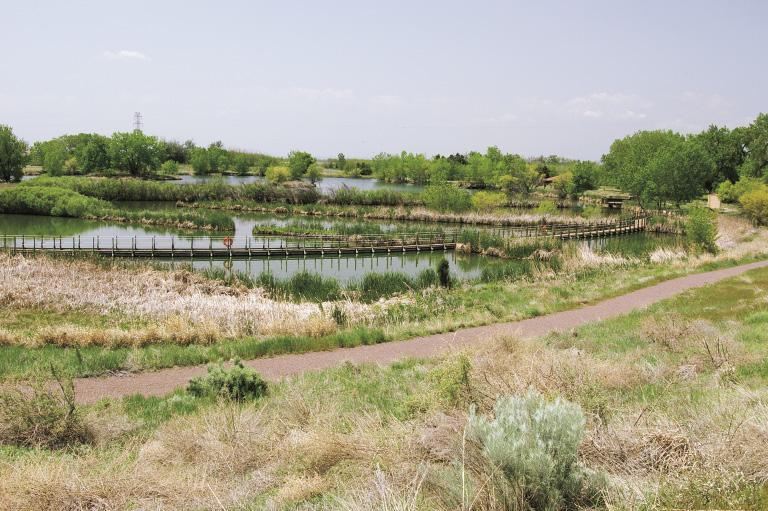
Lake Mary and floating boardwalk