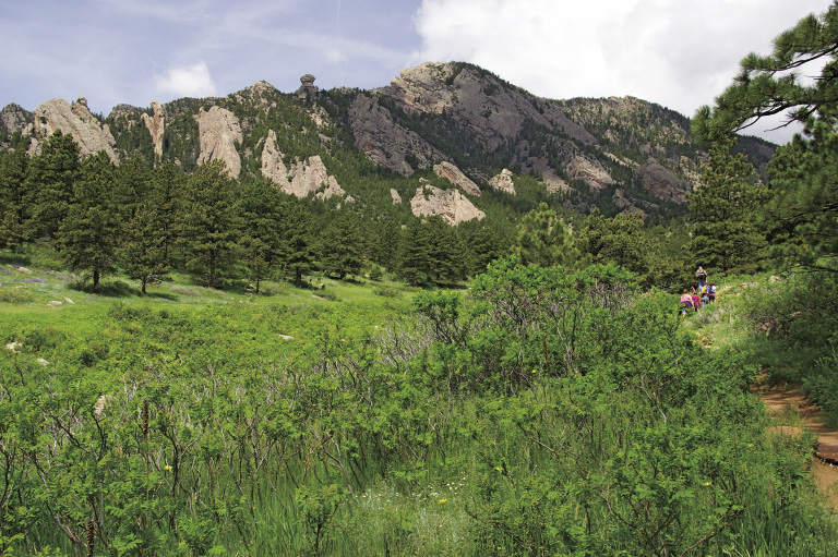
Big Bluestem Trail near its junction with Mesa Trail; Devils Thumb on ridge
5
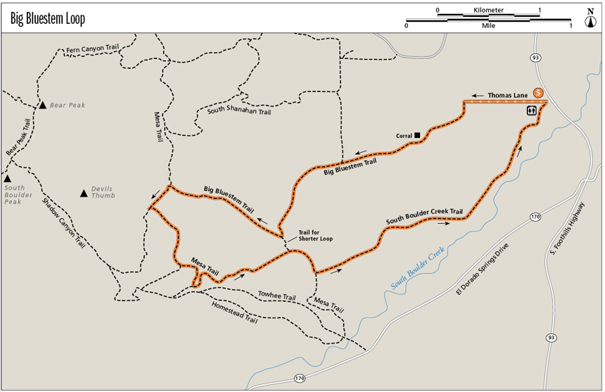
Big Bluestem Loop
Wander through tallgrass and mixed-grass prairie where cattle still graze, then hike up narrow drainages thick with vegetation in view of spectacular rock formations. In spring the wildflowers and flowering bushes send sweet-scented fragrances wafting across the air. Fall brings colorful leaves and berries, which bears eagerly eat to fatten up before winter arrives. Devils Thumb and The Maiden poke their heads into the sky as the land rises abruptly from the Mesa Trail. Sample the various ecosystems of Boulder’s Open Space & Mountain Parks while hiking this moderate loop.
Start: South Boulder Creek Trailhead
Distance: 6.8-mile loop
Approximate hiking time: 2.7 to 3.5 hours
Difficulty: Moderate due to distance
Elevation gain: 940 feet
Trail surface: Natural surface trail and old road (closed to the motorized public), with some rocky sections
Seasons: Best Apr through Nov. Avoid hot summer days—hike in the evening or early morning.
Other trail users: Equestrians
Canine compatibility: Dogs must be leashed before exiting a vehicle at and around trailheads. Dog regulations vary from trail to trail and even seasonally; check www.osmp.org for dog regulations or call (303) 441-3440. For example, dogs must stay on trail and not wander in the fields in the lower section of Big Bluestem. Seasonal leash requirements also exist on different sections of Big Bluestem Trail to protect nesting birds and black bears.
Land status: City of Boulder Open Space & Mountain Parks
Fees and permits: None required
Schedule: Open year-round
Maps: USGS Eldorado Springs and Louisville; National Geographic Trails Illustrated 100 Boulder/Golden; Latitude 40˚: Boulder County Trails
Trail contact: City of Boulder Open Space & Mountain Parks, P.O. Box 791, Boulder, CO 80306; (303) 441-3440; www.osmp.org
Special considerations: Bring water with you, as it is often scarce along this loop. Cattle graze at the beginning and end of this hike. Keep your distance and do not harass them or allow your dog to harass them. Please close all gates behind you.
Finding the trailhead: In Boulder, from the intersection of Table Mesa Drive and Broadway (SH 93), drive south on SH 93 for 2.0 miles to South Boulder Creek Trailhead. Make a right turn, then a quick left turn into the trailhead parking lot. An outhouse and picnic tables are available, but no water.
The Hike
Big bluestem grass, also known as turkey’s foot for its trident-shaped seed head, is native to the tallgrass prairie. Its bluish leaves, which turn red-purple with age, give the grass its name. Although most of eastern Colorado consisted of dry shortgrass prairie before settlers arrived, this ecosystem where the plains meet the mountains contains enough moisture for big bluestem to grow between 3 and 8 feet tall. Accompanying big bluestem are little bluestem and blue grama grasses. They start their growth in spring, then bloom later in summer. Little bluestem can reach a height of 3 feet. Both big and little bluestem provide shelter for small animals and birds. Blue grama, the Colorado state grass, is easy to recognize with its sickle-shape seed head. It’s more typical of shortgrass prairie, but often mixes with little bluestem near the foothills. Birds such as the grasshopper sparrow and spotted towhee build their nests in the grasses.
Big Bluestem Trail near its junction with Mesa Trail; Devils Thumb on ridge
A rare flower, the Ute ladies’ tresses orchid, is found in only a few places in the West, including the wet meadows in Boulder’s Open Space & Mountain Parks (OSMP). Cattle grazing and prescribed burns actually help the orchid’s habitat. As you hike on Big Bluestem and South Boulder Creek Trails, you may encounter grazing cattle. As explained in interpretive signs, livestock grazing is part of the management plan for the plains portion of OSMP.
Yucca, a member of the lily family, and prickly pear cactus, with its bright yellow flowers, grow among spring wildflowers such as blue to purple penstemon, pink geranium, yellow cinquefoil, and white chickweed. Where the earth retains more moisture, ponderosa pine, skunkbrush, and Rocky Mountain juniper grow. Bushes flourish in drainages and gullies: chokecherry, wild plum, hawthorn, and many berry bushes—a gourmet restaurant for bears in the fall. Birds also love bushy places, and their songs produce a beautiful concert for your hike. Watch out for poison ivy in moister areas. In wet shady spots, ferns flourish. This hike is great for watching how small changes in the lay of the land and a tad more moisture create different plant habitats.
Hiking across the open prairie affords great views of the flatiron-type formations and rock outcroppings such as Devils Thumb and the Maiden, a skinnier version of another formation called the Matron. Boulder is famous for the tilted red rocks that jut from the east side of Green Mountain, like irons sitting on their sides. The slanted rocks near Bear Peak and South Boulder Peak have the same geologic history. About 300 million years ago, when Colorado straddled the equator, the Ancestral Rockies rose a little farther west of the current Front Range. Over time, erosion leveled the mountains, washing the red sand and gravel into alluvial fans. Buried later under the Cretaceous Interior Seaway, the eroded material was compressed into sandstone, now called the Fountain Formation. About 65 million years ago, the present Rocky Mountains started to rise and pushed the Fountain Formation up at an angle. As erosion wore down the overlying softer rock strata, the harder sandstone remained, creating interesting tilted formations.
As the trail becomes a single-track and heads up a drainage, you’ll understand why Boulder is so named. The trail definitely becomes rockier. Water-bar steps help prevent erosion and make for a good leg workout. You can hike this loop year-round, though you may find some snowy and even icy spots depending on recent weather.
Miles and Directions
0.0 Start from the South Boulder Creek Trailhead bulletin board. Elevation: 5,460 feet. GPS: N39 57.62' / W105 14.18'. Turn right at the bulletin board and walk to the dirt road, Thomas Lane. Turn left and walk west on Thomas Lane.
0.3 Arrive at a gate, which is the start of Big Bluestem Trail, a double-track here. Note: Boulder OSMP personnel use this road for access.
0.5 Arrive at a gate. Continue straight ahead on the double-track Big Bluestem Trail.
0.9 Arrive at a gate near a corral.
1.5 A trail comes in from the right. Continue straight ahead on the Big Bluestem Trail.
2.0 Arrive at a gate. The trail is now a single-track and gets rockier.
2.2 Junction with the connector trail to the Mesa Trail. Continue to the right (northwest) on Big Bluestem Trail as it travels up a gully. GPS: N39 56.92' / W105 16.00'.
3.0 T intersection with the Mesa Trail. Turn left (southwest) on the Mesa Trail. Elevation: 6,330 feet. GPS: N39 57.20' / W105 16.78'.
3.2 Junction with Shadow Canyon Trail. Continue to the left (southeast) on the Mesa Trail.
3.5 High point. Elevation: 6,400 feet.
3.6 Junction with another Shadow Canyon Trail. Continue to the left (southeast) on the Mesa Trail.
3.8 Remains of an old building.
3.9 Junction with another Shadow Canyon Trail. Continue to the left (north) on the Mesa Trail, which is now as wide as a road.
4.3 Junction with a connector trail to Towhee Trail. Continue straight ahead (northeast) on the Mesa Trail.
4.6 Junction with the connector trail to Big Bluestem Trail. Continue to the right (southeast) on the Mesa Trail.
4.8 Junction with South Boulder Creek Trail. Turn left (northeast) onto this single-track. GPS: N39 56.72' / W105 15.77'.
5.0 Arrive at a gate. Continue straight ahead on South Boulder Creek Trail.
5.5 Arrive at a gate. Continue straight ahead on South Boulder Creek Trail.
6.1 Arrive at a gate. Continue straight ahead (northeast) on South Boulder Creek Trail.
6.5 Arrive at a gate. Continue straight ahead (north) on South Boulder Creek Trail.
6.7 The trail turns left off the double-track onto a single-track through a little grove of cottonwood trees.
6.7 The trail joins a double-track. Turn left onto the double-track.
6.8 One last gate and arrive back at the trailhead.
Option
For a shorter, easy 4.3-mile loop, start as above but make a left turn at mile 2.2 and hike 0.1 mile to the Mesa Trail. Turn left onto the Mesa Trail and continue following the directions above from mile 4.6.
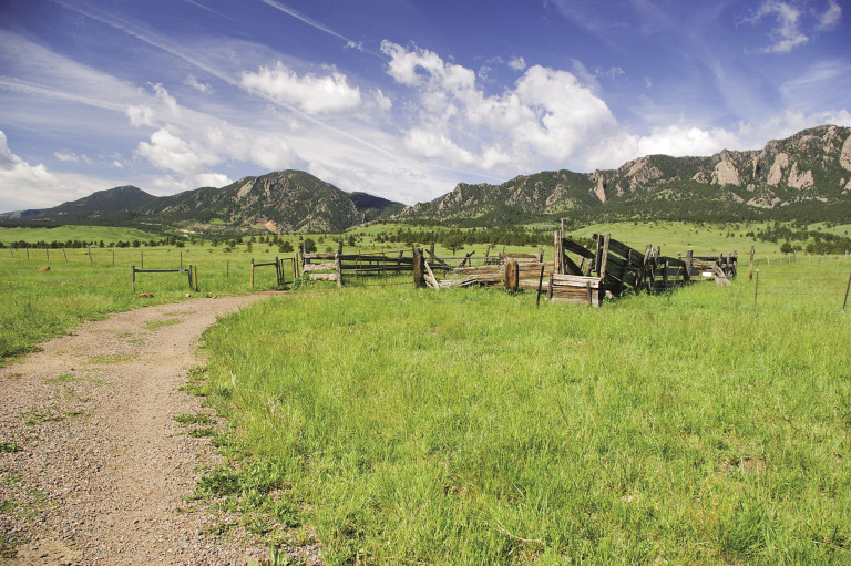
Old corral on Big Bluestem Trail at mile 0.9
Hike Information
Local Information: Boulder Colorado Convention and Visitors Bureau; (303) 442-2911, (800) 444-0447; www.bouldercoloradousa.com
Boulder Chamber of Commerce; (303) 442-1044; www.boulderchamber.com
Local Events/Attractions: Colorado Shakespeare Festival, University of Colorado, Boulder; (303) 492-0554
Colorado Music Festival, Chautauqua Auditorium, Boulder; (303) 449-1397; www.coloradomusicfest.org
Hike Tours: City of Boulder Open Space & Mountain Parks; (303) 441-3440; www.osmp.org
Organizations: Colorado Mountain Club Boulder Group, Boulder; (303) 554-7688; www.cmcboulder.org
OSMP Volunteers, City of Boulder Open Space & Mountain Parks; (303) 441-3440; www.osmp.org