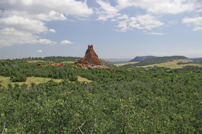
Red Rock from Sharptail Trail at about mile 1.9
9
Swallowtail Trail
Starting in Roxborough State Park, this hike takes you southeast past the old Sundance Ranch. Nelson Ranch Open Space, situated between the hogback and the foothills, provides habitat protection for foxes, elk, bears, coyotes, spotted towhees, migratory birds, and, of course, swallowtail butterflies. The butterfly shape of the Swallowtail Trail winds around a towering red rock of the Fountain Formation, up and over rimrock, passing by ponderosa pine, Douglas fir, oakbrush, smooth sumac, hawthorn, chokecherry, and wild plum, with a touch of prairie full of rabbitbrush for good measure. What shapes do you see while hiking around the red rock?
Start: willow creek and fountain valley trailhead interpretive signs just southwest of the Roxborough State Park Visitor Center
Distance: 6.7-mile figure 8 lollipop
Approximate hiking time: 2.75 to 3.5 hours
Difficulty: Moderate due to length
Elevation gain: 520 feet
Trail surface: Natural surface and rocky trail, and dirt road (closed to the motorized public)
Seasons: Best Apr through Nov. Avoid hot summer days—visit in the evening or early morning.
Other trail users: Access through Roxborough State Park is hiker only. Swallowtail Trail allows hikers, equestrians, and mountain bikers.
Canine compatibility: Dogs not allowed in Roxborough State Park, where this hike starts
Land status: Douglas County Open Space, Colorado state park
Fees and permits: Daily entrance fee or annual pass required for Roxborough State Park
Schedule: Open year-round. Roxborough State Park is day use only. Park hours change with the seasons; check the Web site or call. Douglas County Open Space is open 1 hour before sunrise to 1 hour after sunset. You can cross-country ski or snowshoe Swallowtail Trail in winter if there is enough snow, but the trail is neither marked nor maintained for winter use. Call the Roxborough State Park Visitor Center for snow conditions.
Maps: USGS Kassler; National Geographic Trails Illustrated 135, Deckers/Rampart Range
Trail contacts: Douglas County Open Space, 100 Third Street, Castle Rock; (303) 660-7495; www.douglas.co.us/openspace. Roxborough State Park, 4751 North Roxborough Drive, Littleton; (303) 973-3959; www.parks.state.co.us/parks/roxborough.
Special considerations: Bring water with you, as no potable water is available on the trails. No pets (dogs included) are allowed in Roxborough State Park or on Sharptail Trail. Beware of rattlesnakes and poison ivy.
Finding the trailhead: From C470 and Wadsworth Boulevard (SH 121), drive south on Wadsworth 4.5 miles to Waterton Road (Douglas County Road 217). Turn left onto Waterton Road, drive 1.7 miles to North Rampart Range Road, and turn right. Drive another 2.1 miles on North Rampart Range Road, then turn left onto Roxborough Park Road. Turn right immediately by the fire station and follow the road into the park. Stop at the entrance station to pay the fee, or if it is unattended, stop at the self-serve station. The visitor center parking lot is 2.2 miles from the fire station. Water and restrooms are available at the visitor center, a 0.1-mile walk from the parking lot.
The Hike
Douglas County, with help from Friends of Roxborough and Great Outdoors Colorado, purchased the Nelson Ranch in 2001, creating 695 acres of open space. This undulating valley behind a low tilted ridge (hogback) is anchored by a prominent red rock, a remnant of the Fountain Formation like the uplifted red rock towers in nearby Roxborough State Park. The Nelson family called it Bottle Rock. The open space provides a buffer for Roxborough State Park and protects wildlife habitat. Red foxes, mule deer, rock squirrels, and coyotes live here, while elk pass through. Bears enjoy the plentiful berries and acorns before turning in for their winter deep sleep. In spring and summer, spotted towhees feed under the many different bushes lining the valley.
Fly back in time 300 million years ago when the land we call Colorado straddled the equator. The Ancestral Rockies were eroding, leaving reddish sediment along their east and west flanks. Shallow seas bordered the shrinking range. As sea level dropped, the land dried out and sand dunes developed. Millions of years later, shallow seas would ebb and flow across a flat “Colorado.” Over time the reddish coarse-grained sediment hardened into the Fountain Formation. The buff- to salmon-colored sand dunes became the Lyons Formation. Shales and sandstones from the shallow sea were compressed into the Lykins Formation. These formations are visible across Nelson Ranch in the towering red rock and in the rocky ledges.
Swallowtail Trail loops like a gentle roller coaster around the remote hogback valley—”remote” because access to the area is long, 4 miles from Sharptail Trailhead and 7.9 miles from Indian Creek Trailhead in the Pike National Forest. Entrance through Roxborough State Park is about 2.0 miles one way, but the hike through this picturesque area is worth the effort. The trail winds in and out of Gambel oak (oakbrush) thickets, with mountain mahogany and berry bushes in the mix. An occasional ponderosa pine or Rocky Mountain juniper rises above the smaller shrubs.
After crossing a grassy area full of wildflowers, the trail climbs a ledge of red and buff sandstones with a good view of the valley and Red Rock. A little ponderosa pine grows against the rocks. As the trail drops off the ledge, trees shelter a picnic table. You will traverse more rocky trail, walking over sandy spots that eroded from the sandstone.
After crossing Rainbow Creek, which is often dry, you’ll arrive at the junction with the lower (southern) loop. The first section is open grassland, full of yellow-flowered rabbitbrush, which rabbits eat and use for shelter. You’ll cross another set of sandstone ledges as the trail heads back north. Hawks and prairie falcons soar overhead in the blue Colorado sky, looking for lunch.
As you start back on the upper loop, you’ll reach the junction with Ringtail Trail, where the smooth sumacs turn bright red in fall—a beautiful time to hike. The trail changes to pink feldspar and shiny mica for a short distance. Look for the western tiger swallowtail butterfly. This large yellow and black butterfly with blue and red spots near its tail lays its eggs in the chokecherry bushes.
After you leave Nelson Ranch, look to the left for a rock wall with a window. It is near the southeastern end of Sharptail Trail and is all that remains of an old homestead, slowly being covered with bushes and branches.
Swallowtail Trail provides a quiet and peaceful escape from the hustle and bustle of the nearby Denver metro area.
Red Rock from Sharptail Trail at about mile 1.9
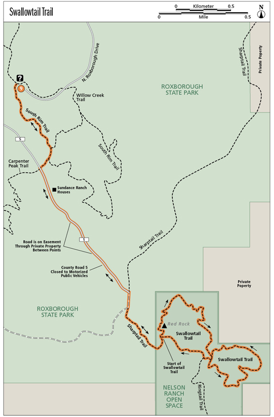
Miles and Directions
0.0 Start from the willow creek and fountain valley trailhead interpretive signs just southwest of the Roxborough State Park Visitor Center. Start to the left of the bulletin board on Willow Creek Trail. Elevation: 6,200 feet. GPS: N39 25.77' / W105 04.13'.
0.45 Junction with Willow Creek Trail. Turn right on South Rim Trail/Carpenter Peak Trail.
0.5 Junction with South Rim Trail. Turn right on Carpenter Peak Trail/Colorado Trail.
0.6 T intersection with Douglas County Road 5. GPS: N39 25.38' / W105 03.98'. Turn left (southeast) and walk on DCR 5. This road is closed to the motorized public, except private inholders and Roxborough State Park personnel.
0.7 The old Sundance Ranch houses.
1.0 Although the sign says no trespassing, DCR 5 is public right-of-way. Please stay on the road.
1.2 Exit private property.
1.5 Junction with Sharptail Trail, which comes in from the left. Continue hiking to the right on Sharptail Trail, which merges with DCR 5.
1.6 Junction with DCR 5. Turn left (south) on the single-track Sharptail Trail, which is closed to mountain bikers, dogs, and motorized equipment. GPS: N39 24.70' / W105 03.43'.
1.9 Trail enters Nelson Ranch Open Space and becomes Swallowtail Trail. This trail is open to hikers, horses, mountain bikers, and pets on leash. There’s a picnic table down a little trail to the right.
2.0 Start/end of Swallowtail Trail loops. Turn left here to hike around the red rock.
2.1 Trail splits. You can go either direction around the red rock.
2.2 Trail splits again. Turn left if you went left around the red rock; turn right if you went right around the red rock. Head north on Swallowtail Trail.
2.5 The trail takes you up on a sandstone ledge (rimrock). There’s a picnic table off to the right as the trail curves off the rimrock.
3.1 Arrive at the middle of the figure 8, where there’s a hitch rail and bench. GPS: N39 24.45' / W105 02.92'. Go straight ahead about 100 feet to the next junction, then turn left onto the lower loop, heading south.
3.7 The trail climbs up along sandstone ledges in switchbacks. At one place you might think the trail goes straight ahead, but it switchbacks to the right.
4.3 Arrive back at the middle of the figure 8. Go straight ahead about 100 feet to the next junction, then turn right onto the upper loop, heading west.
4.4 T intersection with Ringtail Trail. Turn right (northwest) and continue on the upper loop of Swallowtail Trail.
4.7 Arrive back at the start/end of Swallowtail Trail loops. Turn left and return the way you came to the Roxborough State Park trailhead near the visitor center.
6.7 Arrive back at the trailhead.
Option
For a shorter, 5.5-mile hike, just hike the upper loop of Swallowtail Trail. At the 3.1-mile direction above, skip to mile 4.3 and follow the directions from there.
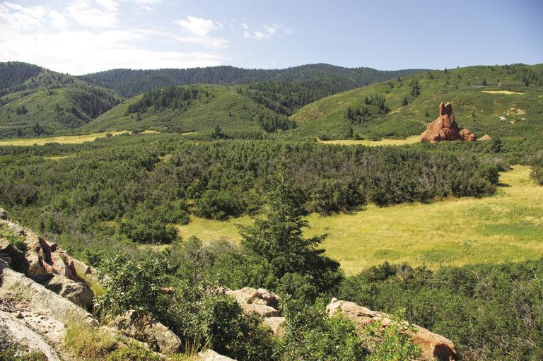
Red Rock, rimrock, and foothills from Swallowtail Trail at mile 2.6
Hike Information
Local Information: South Metro Denver Chamber of Commerce, 6840 South University Boulevard, Centennial; (303) 795-0142; www.bestchamber.com
Local Events/Attractions: Chatfield State Park, Littleton; (303) 791-7275; www.parks.state.co.us/parks/chatfield. Campground
Hike Tours: Douglas County Open Space, 100 Third Street, Castle Rock; (303) 660-7495; www.douglas.co.us/openspace
Organizations: Volunteer Program, Douglas County Open Space, 100 Third Street, Castle Rock; (303) 660-7495; www.douglas.co.us/openspace