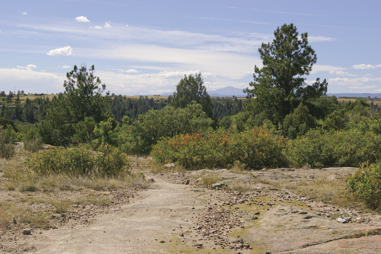
View of Pikes Peak from Mesa Rim Loop at mile 3.5
10
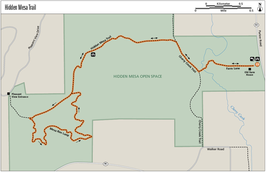
Hidden Mesa Trail
Starting at an old homestead, this trail takes you over Cherry Creek and then through a great example of shortgrass prairie before heading up the mesa. You wander through a juniper ecosystem with some ponderosa pine and prickly pear cactus on this mesa rimmed by Castle Rock Conglomerate, with its cemented cobbles. Views from the top start at Pikes Peak to the south and follow the Front Range to Longs Peak in the north. The Black Forest around Franktown pleases the eye to the east. This open space protects prairie dogs, pronghorns, mule deer, elk, and many raptors.
Start: Hidden Mesa Trailhead
Distance: 6.8-mile lollipop
Approximate hiking time: 2.75 to 3.5 hours
Difficulty: Moderate due to length
Elevation gain: 470 feet
Trail surface: Natural surface trail and paved recreation path
Seasons: Best Apr through Nov. Avoid high-wind and hot summer days—visit in the evening or early morning.
Other trail users: Equestrians and mountain bikers
Canine compatibility: Dogs must be on leash
Land status: Douglas County Open Space
Fees and permits: None required
Schedule: Open year-round from 1 hour before sunrise to 1 hour after sunset
Maps: USGS Castle Rock North
Trail contact: Douglas County Open Space, 100 Third Street, Castle Rock; (303) 660-7495; www.douglas.co.us/openspace
Other: A picnic shelter is available at the trailhead.
Special considerations: There is no water along the trail except for Cherry Creek (not potable) near the trailhead. Beware of rattlesnakes—stay on existing trails.
Finding the trailhead: From I-25, take exit 184, Founder’s Parkway, to SH 86/Franktown. Turn left (northeast) and follow Founder’s Parkway for 4.4 miles as it twists around to its junction with SH 86. Turn left on SH 86 and head east 5.1 miles to Franktown. At the junction of SH 86 and SH 83, turn left (north) onto SH 83 and drive 1.3 miles to the Hidden Mesa Open Space on the left (west) side of the road, just beyond mile marker 52. Turn left into the parking lot. A portable toilet is available. Bring your own water, as no potable water is available.
The Hike
As more people find Colorado attractive and the Denver metro area a good place to live and work, open lands, farms, and ranches are quickly disappearing. People once predicted that homes and towns would sprawl continuously from Fort Collins to Colorado Springs, forming a huge megalopolis. However, Front Range counties and cities and the state of Colorado, in conjunction with private groups, have continuously worked to preserve lands as buffers between communities and as wildlife habitats. Hidden Mesa is one such preserve, a joint effort between the Town of Castle Rock and Douglas County.
The old barn and the log part of the house at the trailhead were built in 1872 by William Brian. This Irishman and his family cultivated about 20 acres of their 160-acre homestead and raised stock on the rest. Their land included the low area and just west of Cherry Creek.
After much revegetation, the riparian area along Cherry Creek is recovering from over a century’s worth of cattle munching on the bushes. The willows had disappeared, but now native chokecherries, wild plums, and willows thrive again, providing nesting and hiding places and “restaurants” for birds and small animals. Hidden Mesa sustains habitat for prairie dogs, pronghorns, elk, coyotes, mule deer, and a variety of raptors. A few burrowing owls make their homes in abandoned prairie dog tunnels. In addition, Douglas County has built natural surface trails for hikers, equestrians, and mountain bikers. This land purchase also provided public land for a missing link in the 24-mile-long Cherry Creek Regional Trail that is proposed to connect Castlewood Canyon State Park to the south and Cherry Creek State Park farther north.
View of Pikes Peak from Mesa Rim Loop at mile 3.5
While you’re hiking across the grassland and along the mesa top, try to imagine over a thousand homes here. Instead you can enjoy a remnant of prairie and mesa, with its marvelous views of the Front Range mountains.
Eagle Scouts have been active at Hidden Mesa. One built the bluebird houses you see along the trail; volunteers from the Audubon Society maintain them. Other Eagle Scouts provided the directional signs and benches at strategic locations.
The rock that rims the mesa and has prevented its erosion to the level of Cherry Creek’s floodplain is Castle Rock Conglomerate, the same rock you can see at the top of Castle Rock itself and in Castlewood Canyon. Small rocks eroded from this formation are strewn along some parts of the trail, especially close to the rim. The deep red stones contain iron oxide. Roundish rocks once rolled around in a streambed, possibly the ancestor of the South Platte River.
You’ll find some interesting features during your hike. A small pond full of cattails seems out of place in the seemingly dry grassland punctuated with yucca and prickly pear cactus. A table formation of rocks creates a great frame for a photo of Pikes Peak. In a fold on the mesa top are the remains of a small ranch dump. Douglas County workers removed twenty-four loads of 30-yard trash containers from this property. They unfortunately found nothing of value.
Hidden Mesa is a great place to daydream while hiking. Rounded rocks become dinosaur gizzard stones, and the breeze evokes visions of prairie schooners sailing across miles of open plains. At the base of the mesa is a grove of large Gambel oaks (oakbrush) that are taller than a typical bush. In the cool shade under their branches sit a picnic table, two benches, and a horse hitch rail. What a great place to have a bite to eat and enjoy the breeze before heading back to the mechanized world!
Green Tip:
When you just have to go, dig a hole 6–8 inches deep and at least 200 feet from water, camps, and trails. Carry a zip-lock bag to carry out toilet paper, or use a natural substitute such as leaves instead (but not poison ivy!!!). Fill in the hole with soil and other natural materials when you’re done.
Miles and Directions
0.0 Start from the Hidden Mesa Trailhead on the west side of the picnic table shelter. Elevation: 6,040 feet. GPS: N39 24.55' / W104 45.74'.
0.5 T intersection with concrete Cherry Creek Trail. GPS: N39 24.50' / W104 46.22'. Turn right (north) and walk along Cherry Creek Trail. A natural surface single-track runs along the right of the concrete trail.
0.9 Junction with Hidden Mesa Trail. GPS: N39 24.78' / W104 46.48'. Turn left (west) onto the natural surface double-track trail.
1.4 Arrive at a gate. The trail becomes a single-track here.
1.7 In a grove of oakbrush are a picnic table, two benches, and hitching post. The trail starts climbing more.
2.3 Start of Mesa Rim Loop. GPS: N39 24.34' / W104 47.51'. There’s a bench here. Turn right and head uphill toward the Pleasant View Entrance.
2.7 Junction of Mesa Rim Loop and the Pleasant View Entrance trail. There’s a bench here. Turn left to continue on Mesa Rim Loop. When the trail crosses the rimrock, keep an eye out for cairns (little rock piles) that mark the way.
3.0 Nice view of Pikes Peak to the south.
4.5 Arrive back at the start of Mesa Rim Loop. Turn right and head downhill. Return the way you came.
6.8 Arrive back at the trailhead.
Option
For a shorter, easy 3.4-mile out-and-back route, hike only to the picnic table and return the way you came.
Burrowing owls received their name because they live underground in burrows, usually adopting a tunnel abandoned by ground squirrels or prairie dogs. They weigh less than six ounces. Active day and night, burrowing owls enjoy eating tiny animals like mice and insects, especially beetles and grasshoppers.
Hike Information
Local Information: Franktown; www.franktowncolorado.com
Castle Rock Chamber of Commerce; (303) 688-4597; www.castlerock.org
Parker Chamber of Commerce; (303) 841-4268; www.parkerchamber.com
Local Events/Attractions: Castle Rock Players (theater), Castle Rock; (303) 814-7740; www.crplayers.org
Colorado Renaissance Festival and Artisan Marketplace, Larkspur; (877) 259-3328; www.coloradorenaissance.com
Castle Rock Wine Fest; (303) 688-4597; www.castlerockwinefest.com
Castle Rock Museum; (303) 814-3164
Franktown Museum; 303-688-3811
Hike Tours: Douglas County Open Space, Castle Rock; (303) 660-7495; www.douglas.co.us/openspace
Organizations: Volunteer Program, Douglas County Open Space, Castle Rock; (303) 660-7495; www.douglas.co.us/openspace