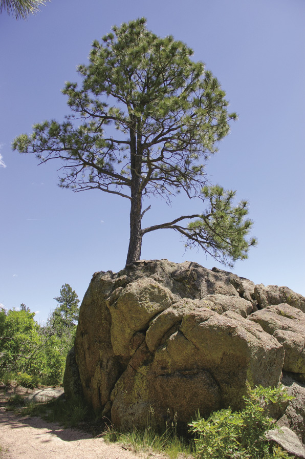
Ponderosa pine growing out of a boulder
12
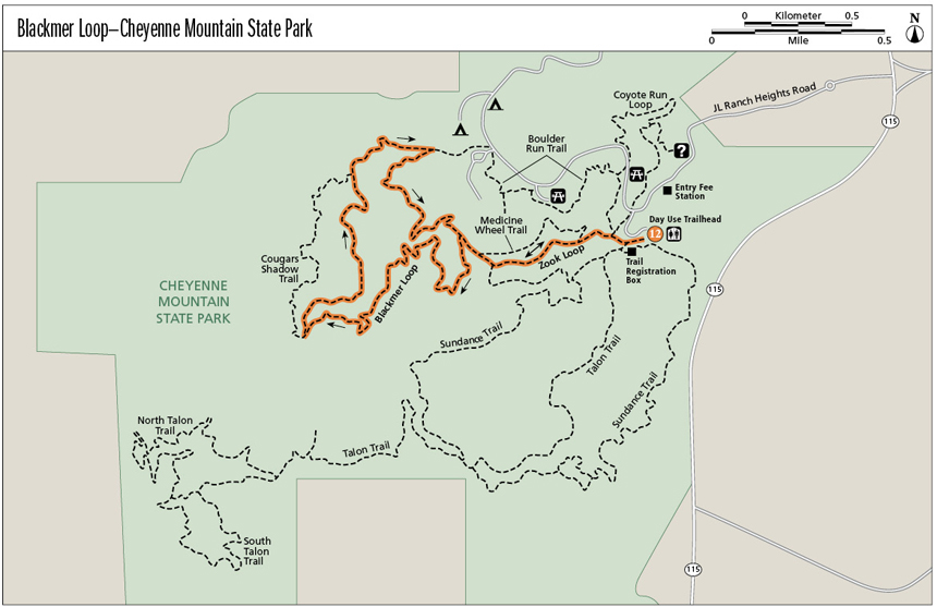
Blackmer Loop—Cheyenne Mountain State Park
Twist and turn up and down along the pleasant Blackmer Loop on the toe of Cheyenne Mountain. After passing a group of car-size boulders, you’ll come upon one with a ponderosa pine growing out of it. The trail generally travels in ponderosa pine and Douglas fir forest, but occasional openings present expansive views of Fort Carson and the eastern plains and of rugged Cheyenne Mountain to the west. Rustic remnants of ranching lie unused in fields along the north section of trail. Interpretive signs along Blackmer Loop and Zook Loop explain different park features.
Start: Day Use Trailhead
Distance: 4.7-mile lollipop
Approximate hiking time: 2 to 2.5 hours
Difficulty: Moderate due to distance and elevation gain
Elevation gain: 525 feet
Trail surface: Natural surface and rocky trail
Seasons: Best Apr through Nov
Other trail users: Mountain bikers
Canine compatibility: Dogs not allowed
Land status: Colorado state park
Fees and permits: Daily fee or annual pass required
Schedule: Open year-round. Check Web site or call for current conditions.
Maps: USGS Cheyenne Mountain
Trail contact: Cheyenne Mountain State Park, 410 JL Ranch Heights Road, Colorado Springs, 80926; (719) 576-2016; www.parks.state.co.us/parks/cheyennemountain
Other: Visitor center hours are 8:00 a.m. to 5:00 p.m. daily. Fort Carson Army Base is east of Cheyenne Mountain State Park. If severe weather is in the area, you may hear a siren that alerts soldiers in the field. At noon reveille, a bugle call, resounds across the park.
Special considerations: Bring water because none is available on this hike. Beware of rattlesnakes. Smoking is not allowed on the trails or in the backcountry.
Finding the trailhead: From I-25 exit 140, head southbound on SH 115 (Nevada Avenue). In 5.5 miles, just past mile marker 42, turn right at the traffic light onto JL Ranch Heights Road. At the roundabout, drive halfway around so you continue heading west. The visitor center is 0.7 mile and the entry station is 0.8 mile from SH 115. After paying the fee, drive 0.1 mile and turn left into the Day Use Trailhead parking lot (A new sign says limekiln grove trailhead.). There are restrooms and water at both the visitor center and the trailhead.
The Hike
To access Blackmer Loop, hike on Zook Loop from the Day Use Trailhead along the Limekiln Valley. Gambel oaks (scrub oaks) grow tall here, more like trees than their usual bush form. A few ponderosa pines and Rocky Mountain junipers grow between the scrub oaks. Interpretive signs tell about the mountain lions and black bears that live in Cheyenne Mountain State Park (CMSP). A short trail climbs a little drainage connecting Zook Loop with Blackmer Loop. Along the loop you can occasionally see 9,564-foot Cheyenne Mountain and some interesting rock formations. See if you can find a camel shape in one of them.
Within Cheyenne Mountain lies a fortified command center of the North American Air Defense Command (NORAD). Excavation through solid granite to build the underground post started in 1961 and took three years to complete. The operations center began its mission in 1966. It originally provided command and control for potential incoming Soviet bombers, which later changed to incoming nuclear warheads on intercontinental ballistic missiles (ICBMs). Various American and Canadian military agencies used the facility. When the Cold War ended, NORAD started tracking all aircraft, especially those without flight plans, including drug-smuggling planes. They also monitored over 8,200 objects orbiting the earth, alerting various world militaries if one entered the atmosphere to avoid misunderstandings or panic.
In 2006 most operations were moved to nearby Peterson Air Force Base. The command center remains on “warm” standby, watching once again for missiles. NORAD may be best known for tracking Santa’s flight on Christmas Eve. The northern section of Blackmer Loop is only about 0.15 mile from the NORAD access road.
The showpiece of this hike is the ponderosa pine growing out of a large granitic boulder. An interpretive sign describes ponderosa pines, Abert’s squirrels, and porcupines. Farther along, the trail crosses green fields of tall grass growing around an old ranch fence and a huge tire with a pipe sticking out of it. The ranchers used the tire to try to catch water for their cattle.
Lloyd and Dorothy Jones once owned 1,500 acres here and operated a cattle ranch called the JL Ranch until the mid-1900s. They lived in a house near the present-day entrance to NORAD. The Broadmoor Hotel took guests on trail rides through the area during part of that time. Since the 1950s the area has been closed to the public, with little ranching activity.
Green Tip:
Pack out what you pack in, even food scraps because they can attract wild animals. Orange peels and other food do not readily decompose in Colorado’s high and dry climate.
In 1997 Colorado Springs voters approved a 0.1 percent increase in sales tax to fund open space. When 2,500 home sites were planned on the JL Ranch, the city of Colorado Springs’ Trails and Open Space Commission (TOPS) campaigned to purchase the land. Collected sales tax funds helped the city of Colorado Springs partner with Colorado State Parks, Great Outdoors Colorado (GOCO), and other private organizations to purchase the JL Ranch in June 2000. Now called Cheyenne Mountain State Park, it is the only state park in El Paso County. The 1,680-acre park opened in 2006 with 20 miles of trails that were designed to protect wildlife and rare species. Only 80 acres will contain development such as the visitor center, campground, picnic grounds, and camping cabins. An event facility may also be built. GOCO has invested close to $24 million in the park.
Between 2007 and 2009 about 1,000 acres along the east side and top of Cheyenne Mountain were purchased by the city of Colorado Springs and Colorado State Parks as additions to CMSP. Keep an eye on the CMSP Web site for plans for this addition.
Ponderosa pine growing out of a boulder
Miles and Directions
0.0 Start from the Day Use Trailhead to the right (west) of the restrooms at the edge of the pavement. Elevation: 6,055 feet. GPS: N38 43.88' / W104 49.25'. Walk about 200 feet to the trail registration box and sign in. Turn right here onto Zook Loop (blue).
0.1 Junction with Coyote Run. Head left to continue on Zook Loop.
0.2 Junction with Medicine Wheel. Continue straight ahead on Zook Loop.
0.5 Junction with Blackmer Loop (dark purple). GPS: N38 43.81' / W104 49.74'. There’s a bench here and an interpretive poster about black bears. Turn right onto Blackmer. You can see the round trail marker above some small boulders.
0.6 Junction with Medicine Wheel. Continue straight ahead on Blackmer Loop.
0.7 Start/end of Blackmer Loop. Turn left.
1.3 Viewpoint to the east with a metal bench, and as you curve right, there is a good view of Cheyenne Mountain and some interesting rock formations. GPS: N38 43.84' / W104 49.98'. The trail twists and turns while climbing.
2.1 Junction with Cougar's Shadow Trail. Turn right to continue on Blackmer Loop. The trail winds past some huge boulders.
2.4 Ponderosa pine growing out of a huge boulder. There’s a bench and interpretive sign. GPS: N38 43.74' / W104 50.17'.
2.9 Junction with Cougar's Shadow Trail. Continue straight ahead here.
3.0 Fence or old corral. GPS: N38 44.09' / W104 50.15'. For the next 0.1 mile look for ranching and farming remnants.
3.3 Junction with Boulder Run Trail, which goes to the campground. Turn right and head downhill to finish Blackmer Loop.
4.0 Start/end of Blackmer Loop. Turn left and return the way you came.
4.7 Arrive back at the trailhead.
Options
1. If you are staying at the campground, a combination of Boulder Run Trail and Blackmer forms a 3.7-mile lollipop. From the campground, hike down the road to the Boulder Run crosswalk. Turn right onto Boulder Run (gold). GPS: N38 44.11' / W104 49.74'. Hike 0.2 mile to the junction with Blackmer Loop (dark purple). Turn left and hike down Blackmer 0.7 mile to the junction with the Blackmer spur to Zook Loop. Walk straight ahead to continue on Blackmer back to Boulder Run. Follow the directions above, starting at mile 0.7.
2. The many trails in CMSP offer a variety of hiking options.
Hike Information
Local Information: Colorado Springs Convention and Visitors Bureau; (877) 745-3773; www.experiencecoloradosprings.com
Local Events/Attractions: Cheyenne Mountain Zoo, Colorado Springs; (719) 633-9925; www.cmzoo.org
Florissant Fossil Beds National Monument; (719) 748-3253; www.nps.gov/flfo
Garden of the Gods Visitor & Nature Center, Colorado Springs; (719) 634-6666, (719) 219-0101; www.gardenofgods.com
United States Air Force Academy, USAFA; (719) 333-2025; www.usafa.af.mil
Hike Tours: Cheyenne Mountain State Park, Colorado Springs; (719) 576-2016; www.parks.state.co.us/parks/cheyennemountain
Organizations: Friends of Cheyenne Mountain State Park, Colorado Springs; (719) 576-2016; www.friendscmsp.org
When Cheyenne Mountain State Park was established in 2000, the property’s shape looked like a bear with one paw and nose pointing east, an ear to the north, the other paws to the south, and tail to the west.