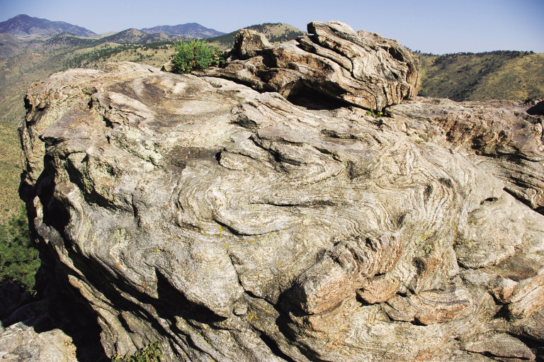
Folded rock with small Rocky Mountain juniper at overlook at mile 7.1
22
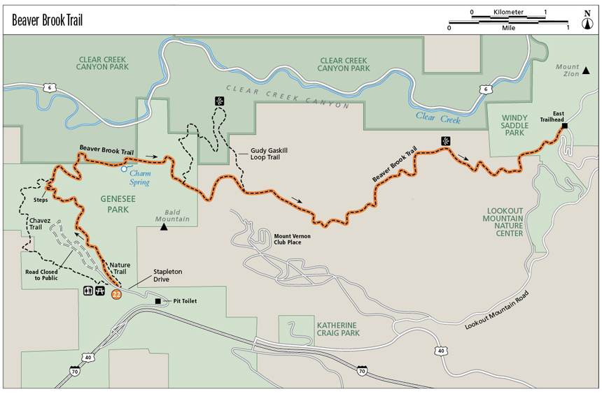
Beaver Brook Trail
The Beaver Brook Trail travels like a roller coaster through a variety of ecosystems and interesting rocky sections. Starting in Genesee Park on the west, the trail drops 840 feet to Beaver Brook in a wild, primitive area so close to Denver. It then climbs 1,200 feet until leveling out before descending 880 feet to Windy Saddle above Golden. Viewpoints look down into Clear Creek Canyon, where semitrucks look like ants. Although sections are open and dry, little oases and a small waterfall provide surprises along this trail through the first Denver Mountain Park and two Jefferson County Open Space parks.
Start: West Beaver Brook Trailhead, Braille Nature Trail
Distance: 8.7 miles point to point
Approximate hiking time: 3.5 to 5 hours
Difficulty: Most Difficult due to length, many elevation gains and losses, and rocky areas
Elevation gain: 1,400-foot gain and 1,920-foot loss
Trail surface: Natural surface and rocky trail
Seasons: Best May through Nov
Other trail users: Hikers only; mountain bikers allowed on the easternmost 0.2 mile, which is Lookout Mountain Trail in Windy Saddle Park
Canine compatibility: Dogs must be on leash
Land status: Denver Mountain Parks, private land on easements, Jefferson County Open Space
Fees and permits: None required
Schedule: Open year-round from 5:00 a.m. to 11:00 p.m.
Maps: USGS Evergreen, Morrison; National Geographic Trails Illustrated 100 Boulder/Golden; Latitude 40˚: Colorado Front Range
Trail contacts: Denver Mountain Parks, Denver; (303) 697-4545; www.denvergov.org. Jefferson County Open Space (Gudi Gaskill Loop), 700 Jefferson County Parkway, Suite 100, Golden; (303) 271-5925; www.co.jefferson.co.us/openspace
Other: Stay on the trail when passing through private property. Camping, fires, and hunting are prohibited. Observe Leave No Trace ethics of land use. Half-mile markers are posted beginning at the east entrance at Windy Saddle. Take note of the mile marker information as you hike so rescue personnel can decide the closest access point if emergency assistance is needed. On some parts of this trail, neither GPS nor cell phones may work.
Special considerations: Potable water is not available along this trail, so be sure to bring plenty. North-facing slopes may be icy at times in winter.
Finding the trailhead: For the point-to-point hike, park one car at the east trailhead at Windy Saddle, then drive a second car to the west trailhead on Stapleton Drive to start the hike. Some people prefer to hike east to west, so at the end of the hike they lose elevation then regain it. If you’d prefer to hike east to west, leave a car at the west trailhead and start hiking from Windy Saddle.
East trailhead at Windy Saddle: From I-70 exit 256, Lookout Mountain, turn right then turn immediately left onto Mount Vernon Canyon Road. In 1.5 miles turn right onto Lookout Mountain Road. Follow the twisty road up past Buffalo Bill’s Museum and Grave, then downhill on a twistier Lariat Loop Road for 5.9 miles total from Mount Vernon Canyon Road to the Windy Saddle parking lot on the left. No facilities are available at the trailhead.
West trailhead: From I-70 exit 253, Chief Hosa, turn right then immediately right onto Stapleton Drive, a broad dirt road. Drive down Stapleton for 1.2 miles to the trailhead parking areas. The trail starts from the lower parking lot. Pit toilets are located at 0.7 mile near a small parking area on the left along Stapleton Drive. This parking area also serves as winter parking for trail access in that area of Genesee Park.
The Hike
Imagine back in time when I-70 didn’t exist, and trains transported people and goods in a roadless Clear Creek Canyon. In 1871 the Colorado Central Railroad began its journey from Golden to the mines in Central City and Black Hawk. Gilpin County residents approved a bond issue with the stipulation that the rails had to reach Central City by June 1, 1872. Stations were built at frequent intervals along the way to load coal, lumber, and hay and to provide water for the steam engines. The railroad company built a dancing and picnic pavilion where Beaver Brook flowed into Clear Creek (near today’s tunnel 2). A sixty-step staircase led up to the structure, where Denver residents made merry on many a summer night. The Beaver Brook Depot was removed in 1893.
Fast-forward a few years to 1910, when John Brisben Walker approached Denver’s chamber of commerce and the Denver Real Estate Exchange with his idea for a system of roads and parks in the mountains west of Denver that would be accessible to tourists. Frederick Law Olmstead Jr., a landscape architect, was hired to study and report on possible lands and routes. Plans were discussed for a road up Lookout Mountain near Golden—the Lariat Trail. Denver citizens approved a mill levy and purchased Genesee Park in 1912. The Lariat Trail Road was completed in 1914. Denver purchased Lookout Mountain Park in 1916 and buried Buffalo Bill Cody there the following year. Chief Hosa Lodge and campground were built near Genesee Park to provide meals and lodging. The complete 68.2-mile loop went from Denver to Golden to Genesee to Bergen Park, then through Evergreen, down Bear Creek Canyon to Morrison, and back to Denver.
Hiking and mountaineering enthusiasts established the Colorado Mountain Club (CMC) in 1912. A CMC committee encouraged the Denver Mountain Parks Commission to build trails as well as roads. In 1917 the commission accepted their trails plan and appropriated money. CMC members designed the Beaver Brook Trail and worked with Denver to build it. The intrepid hikers also convinced the Colorado & Southern (C&S) Railroad to build a station platform at the old Beaver Brook stop. The trail started at the train stop and climbed out of Clear Creek Canyon. In about 0.5 mile it forked, with the right branch leading to Chief Hosa Lodge/campground and the left branch (perhaps originally named Colorow Trail) heading toward Golden. By fall 1919 the trail had been completed to Windy Saddle.
Folded rock with small Rocky Mountain juniper at overlook at mile 7.1
A typical Beaver Brook Trail outing for CMC members in 1921 included taking the interurban to Golden for 52 cents round-trip. The hikers then caught the C&S train to Beaver Brook for 42 cents one-way. With lunch and a cup in hand to gather water from springs and creeks, the hikers walked the 11 miles of the Beaver Brook Trail to Windy Saddle, then down Chimney Gulch Trail to Golden, where they caught the interurban back to Denver.
The last train up Clear Creek Canyon ran in May 1941. Three years later a flash flood down Bear Gulch washed out the lower portion of the Beaver Brook Trail to Clear Creek Canyon.
Hiking the trail is an adventure. After it reaches Beaver Brook, an interesting but easy rock scramble presents itself. As you head up an unnamed gulch, the trail gets a little confusing over rock slabs—look for yellow diamonds or fleur-de-lis-shaped markers. The trail follows ridges and meadows, with several overlooks along the way providing good views into Clear Creek Canyon. Near Windy Saddle, several rocky ledges require some rock scrambling with good handholds and footholds, completing the adventure.
Miles and Directions
0.0 Start from the west trailhead at Stapleton Drive by the bulletin board. Elevation: 7,400 feet. GPS: N39 43.02' / W105 18.90'. Start hiking to the left on Braille Nature Trail, which has several interpretive signs along the way.
0.25 B/B 8.5 (miles) sign. Little red and white B/B (Beaver Brook) signs are posted every 0.5 mile. This sign is the first one from the west.
0.3 Junction with Beaver Brook Trail. Turn left and head downhill along Bear Gulch.
0.8 Trail comes in from the left (undergoing restoration). Continue downhill on Beaver Brook Trail.
1.4 Trail junction by a big rock slab on the left. Straight ahead may be blocked by tree branches. Turn right and walk down the stone steps of Beaver Brook Trail. Some narrow rocky ledges are just beyond this point.
1.7 Junction with Chavez Trail. GPS: N39 43.88' / W105 19.56'. Continue straight ahead and downhill on Beaver Brook Trail. The trail crosses some interesting rock slabs, which require a bit of hand and foot work (rock scrambling). The trail makes a right U-turn up a drainage just past B/B 7.0. This point is the lowest on the hike. After crossing the little creek, you may lose the trail in the rock slabs. Look for red and white B/B signs or yellow diamonds to find the trail. The trail then climbs quite steeply.
2.0 A blocked trail comes in from the right. Continue uphill. The trail turns left over a creek, then crosses an open grassy area as it continues to climb.
2.3 A rock outcropping to the left offers a view of Clear Creek below and Travois Trail in Centennial Cone Park above and to the north. GPS: N39 44.01' / W105 19.28'. This part of Beaver Brook Trail is in Jefferson County’s Clear Creek Canyon Park. The trail keeps climbing steadily.
2.6 The trail is in thick forest and curves left by Charm Spring. The spring may be dry.
2.8 The trail climbs up through some rock outcroppings and goes back into Genesee Park.
3.2 Junction with the trail around Bald Mountain. Continue to the left on Beaver Brook Trail. In about 250 feet is a viewpoint to the left near the B/B 5.5 sign. GPS: N39 43.96' / W105 18.50'.
3.6 Junction with west end of Gudy Gaskill Loop. GPS: N39 43.82' / W105 18.32'. See Option 2 for information on this side trail.
3.8 Junction with a double-track trail (Mount Vernon Access) and Bald Mountain Loop. Make a right turn onto the double-track and hike down it a few feet. Beaver Brook Trail then turns left and becomes a single-track again.
4.4 Junction with the east end of Gudy Gaskill Loop. GPS: N39 43.69' / W105 17.70'. Continue straight ahead on Beaver Brook Trail.
5.7 The trail crosses a sunny ridge between drainages.
6.2 A private property on either side of trail sign. For the next 1.4 miles, the trail is on an easement. Please stay on the trail.
6.6 The trail curves left over a creek, which when it has water in it, tumbles in a pretty little waterfall on the right.
7.1 A rocky outcrop with a good view down into Clear Creek Canyon is on the left. GPS: N39 44.07' / W105 15.85'. Take a few minutes to walk out there for both the view and the interesting rocks forming the overlook.
7.6 The trail climbs up a rock (good hand- and footholds), passes another private property on either side of trail sign, then enters Jefferson County’s Windy Saddle Park. The trail goes over a series of various rocks and ledges for the next 0.4 mile.
8.1 The trail appears to split around a house-size boulder. Take the branch through a split in the boulder. (The other branch goes through some juniper trees.)
8.3 The trail crosses two boulder fields.
8.4 Junction with Lookout Mountain Trail. Continue to the left to Windy Saddle.
8.7 Arrive at the east trailhead at Windy Saddle parking lot. Elevation: 6,880 feet. GPS: N39 44.21' / W105 14.70'.
Options
1. If you’d prefer to hike the recommended route east to west, starting at Windy Saddle, read the directions above backwards or download the Miles and Directions from www.aboutwilderness.com.
2. For a 10.3-mile hike, at mile 3.6 above, turn left onto Gudy Gaskill Loop. This 2.4-mile trail loses about 200 feet elevation as it winds its way at the edge of the forest to an overlook into Clear Creek Canyon. It then climbs about 200 feet to join Beaver Brook Trail at mile 4.4 above. Turn left and continue following the above directions to the east trailhead.
3. If you can’t do a car shuttle, you can hike from either trailhead for whatever distance that time allows. Some suggestions:
3a. From the east end, hike to the overlook at mile 7.1 above for a 3.2-mile out-and-back hike.
3b. For a 10.4-mile round-trip, from the west end, hike down the Braille Nature Trail then Beaver Brook Trail to Gudy Gaskill Loop at mile 3.6 above. Turn left, hike the loop, then turn right onto Beaver Brook Trail at mile 4.4 above. Hike 0.8 mile to the west end of Gudy Gaskill Loop and return the way you came.
3c. From the west end, hike down Braille Nature Trail then Beaver Brook Trail to the junction with Chavez Trail. Turn left and follow the trail along pretty little Beaver Brook until the trail heads back uphill along two different gulches to return back to the trailhead. This loop is about 3.5 miles and has an 840-foot gain.
Hike Information
Local Information: Greater Golden Chamber of Commerce, Golden; (303) 279-3113; www.goldenchamber.org
Evergreen Chamber of Commerce and Visitor Information Center; (303) 674-3412; www.evergreenchamber.org
Local Events/Attractions: Lariat Loop Scenic and Historic Byway, Golden; (720) 971-9649; www.lariatloop.org
Buffalo Bill Museum, Golden; (303) 526-0747; www.buffalobill.org
American Mountaineering Center, Golden; (303) 279-3080; www.mountaincenter.org
Colorado Railroad Museum, Golden; (303) 279-4591, (800) 365-6263; www.crrm.org
Coors Brewery, Golden; (303) 277-BEER, (866) 812-2337; www.coors.com
Hike Tours: Colorado Mountain Club, Golden; (303) 279-3080; www.cmc.org
Organizations: Denver Mountain Parks Foundation; www.denvermountainparks.org
In the May 1926 issue of the Colorado Mountain Club’s Trail & Timberline, Alice Hale described designing the Beaver Brook Trail: “[I]t took time and thought . . . to make it the best way, . . . with the finest views, with the spring just where it is needed, and the charming dips into the steep cool ravines coming as a sharp contrast to the long stretches on the very edge of the hills.”