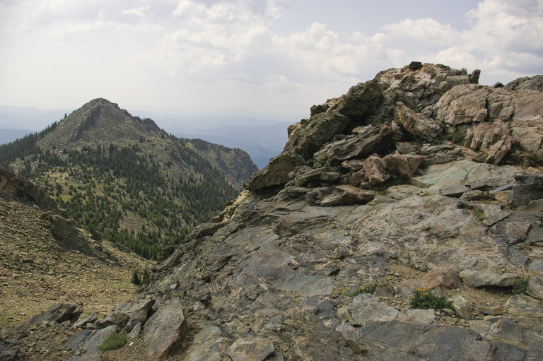
The top of the north Sister looking to the south Sister
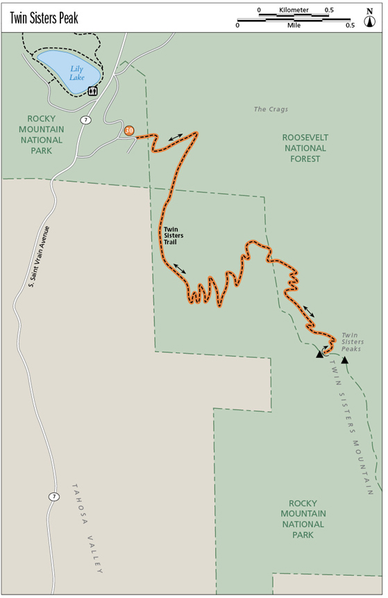
30
Twin Sisters Peak
Until the 1970s fire guards scanned a large region for the telltale smoke of a forest fire from the Twin Sisters Fire Lookout perched on the rocky peak. Some remains of the lookout can still be seen at this hike’s destination. Starting off in a lodgepole pine, spruce, and fir forest, the constantly climbing trail later winds through a beautiful limber pine forest. Higher still, it crosses alpine tundra. Scramble up the rock ridge at the top for a great view of Longs Peak and Mount Meeker. Bighorn sheep may be grazing nearby.
Start: Fence at the access road turnaround where Twin Sisters Trail starts
Distance: 7.4 miles out and back
Approximate hiking time: 3 to 5 hours
Difficulty: Difficult due to elevation gain and elevation
Elevation gain: 2,253 feet
Trail surface: Natural surface and rocky trail
Seasons: Best mid-June through early Oct
Other trail users: Equestrians
Canine compatibility: Dogs not permitted
Land status: National park, national forest, national park wilderness
Fees and permits: None required for day use. Backcountry camping permit (fee charged) required for overnight camping in Rocky Mountain National Park. Food canisters are required for backcountry camping below treeline from May 1 through Oct 31. For information about backcountry camping permits, call (970) 586-1242 or go to www.nps.gov/romo/planyourvisit/backcountry.htm.
Schedule: Open year-round
Maps: USGS Longs Peak; National Geographic Trails Illustrated 301 Longs Peak/Bear Lake/Wild Basin or 200 Rocky Mountain National Park; Latitude 40˚: Colorado Front Range Trails
Trail contact: Rocky Mountain National Park, 1000 Highway 36, Estes Park; (970) 586-1206, (970) 586-1333 (24-hour recorded message); www.nps.gov/romo
Other: The elevation gain and distance in the description below may vary from what you find in Rocky Mountain National Park literature because of different starting locations.
Special considerations: Make sure to get an early start and be back below treeline before thunderstorms develop. There is no water along this trail, so bring plenty. Bring extra warm clothes, including gloves. The ever-present wind gets mighty chilly above treeline, even in summer. The trail is neither marked nor maintained for winter use. In season, hunters use national forest lands that are crossed by Twin Sisters Trail (hunting is not allowed in Rocky Mountain National Park).
Finding the trailhead: In Boulder, from 28th Street (US 36) and Canyon Boulevard (SH 119), head north on US 36 to its junction with SH 66. Turn left on SH 66 and drive through Lyons to the yield sign at the T intersection (US 36 and SH 7). Turn right onto US 36 and drive 21 miles to Estes Park. At the intersection of US 36 and SH 7 in Estes Park, turn left onto SH 7 south and drive 6.3 miles to the Lily Lake and Twin Sisters turnoffs. Turn left and immediately right onto the dirt road to the Twin Sisters trailhead and drive about 0.4 mile. Park on the right side of the road going up, or park in the parking lot at SH 7 and walk 0.4 mile up the road. Vault toilets are available across SH 7 at the Lily Lake parking area. No water is available along the trail or in the parking lots.
The Hike
When President Woodrow Wilson signed the bill creating Rocky Mountain National Park (RMNP) in January 1915, Twin Sisters Peaks were part of the Colorado National Forest. Two years later Twin Sisters and the valley to the west were added to RMNP. The valley consisted of many private properties, which made park management difficult. In 1926 the valley was removed from RMNP, but Twin Sisters remained part of the park.
The USDA Forest Service had built a trail and fire lookout on the peak in 1914. This small, 5-by-7-foot structure sat on a rocky point, with a great 360-degree view through all its windows. The person(s) manning the lookout in summer led an interesting life. They lived below in a small rock cabin—now the electronics building—furnished with bunk beds, a table, chairs, and a small wood stove. Refrigeration came by way of a screened box set in a window. A barrel collected water from the roof when it rained; otherwise, the closest source of water was a spring a mile down the trail. Wood sometimes arrived by horse, or the fire guard had to hike into the national forest to pick up wood and carry it back uphill. A lightbulb in the cabin would start to glow when lightning was near. The lookout had lightning rods, and one fire guard couple reportedly would make a dash to the lookout from the less-protected cabin during thunderstorms. Besides being grounded, the guard would stand on a little footstool with telephone-insulator legs for extra protection. If a fire were spotted, the fire guard would call headquarters with readings to pinpoint the fire’s location.
In 1925 RMNP took over management of Twin Sisters Fire Lookout. Eleven years later the Civilian Conservation Corps reconstructed the trail, which was popular with both hikers and equestrians. An article in the June 9, 1922, Estes Park Trail reported that more than 700 people hiked to the tower the previous summer. By the 1930s over 1,100 people visited the fire lookout annually.
The stock market crash of 1929 created a world-wide depression. In 1933 Congress passed the Emergency Conservation Work Act, creating the Civilian Conservation Corps (CCC). Young, unemployed, unmarried men between eighteen and twenty-five years old could join. Natural resources conservation, including forest fire fighting and trail building and maintenance, became the CCC’s mission.
The top of the north Sister looking to the south Sister
RMNP reconstructed the lookout tower in 1949 or 1950. The new lookout sat on a platform with railings, towering above the rocks on metal legs. A staircase led to the platform. An Osborne fire-finder sat inside surrounded by windows. This device was invented in 1911 by William Bushnell Osborne Jr. to pinpoint forest fires so ground crews would know how to reach the blaze. Osborne continued to improve his fire-finder until the final version in 1934, which is still in use today in some national forests. The instrument had sights similar to a rifle to obtain readings and a metal tape to determine the distance.
By the 1970s fire-finding technology had improved, and the Twin Sisters Fire Lookout was no longer used for observation. The structure started to deteriorate, and RMNP management became concerned about the safety of curious hikers. The Youth Conservation Corps removed the tower in 1977. You can still see some of the concrete footings and metal anchors in the rocks at the summit. One has what looks like “1915” scratched into it.
A beautiful limber pine forest starts at about mile 2.5. With its five needles to a packet, the tree is very distinctive. The name “limber” comes from its flexible branches. This tree grows in rocky areas and exposed ridges with thin soils, where the winds can blow fiercely. Long taproots penetrate fractures in the rocks to help anchor the trees. While you hike up the trail, keep an eye out for 3- to 10-inch-long pinecones—you’ll know you’re in limber pine territory.
Miles and Directions
0.0 Start from the fence at the access road turnaround where Twin Sisters Trail starts. Note: Twin Sisters Trail is listed in some Rocky Mountain National Park literature as starting at the Lily Lake Trailhead.
375 feet Twin Sisters bulletin board. Turn left here onto single-track trail. Elevation: 9,200 feet. GPS: N40 18.19' / W105 32.08'. The trail travels through the Roosevelt National Forest for a while, then when it re-enters the national park, you are in the Rocky Mountain National Park Wilderness Area.
1.1 Viewpoint with great view of Longs Peak to the west. GPS: N40 17.72' / W105 31.94'.
2.8 Enjoy the beautiful limber pine forest.
3.6 Twin Sisters electronic site stone building. The trail climbs through rocks to reach the summit.
3.7 Top of the northwest Twin Sisters peak. Elevation: 11,413 feet. GPS: N40 17.34' / W105 31.13'. Be sure to look over the ridge to the west side to see if any bighorn sheep are grazing below and for a spectacular view of Longs Peak and Mount Meeker. Return the way you came. (The southeast Twin Sisters peak is 11,428 feet.)
7.4 Arrive back at the trailhead.
Hike Information
Local Information: Estes Park Convention & Visitors Bureau; (800) 443-7837, (970) 577-9900; www.estesparkcvb.com
Local Events/Attractions: MacGregor Ranch, Estes Park; (970) 586-3749;www.macgregorranch.org
Longs Peak Scottish Irish Festival, Estes Park Convention & Visitors Bureau; (800) 443-7837, (970) 577-9900; www.estesparkcvb.com
Scandinavian Midsummer Festival, Estes Park Convention & Visitors Bureau; (800) 443-7837, (970) 577-9900; www.estesparkcvb.com
Elk Fest, Estes Park Convention & Visitors Bureau; (800) 443-7837, (970) 577-9900; www.estesparkcvb.com
Hike Tours: Rocky Mountain National Park Ranger-Led Programs, Estes Park; (970) 586-1206; www.nps.gov/romo
Organizations: Rocky Mountain Nature Association, Estes Park; (970) 586-0108; www.rmna.org