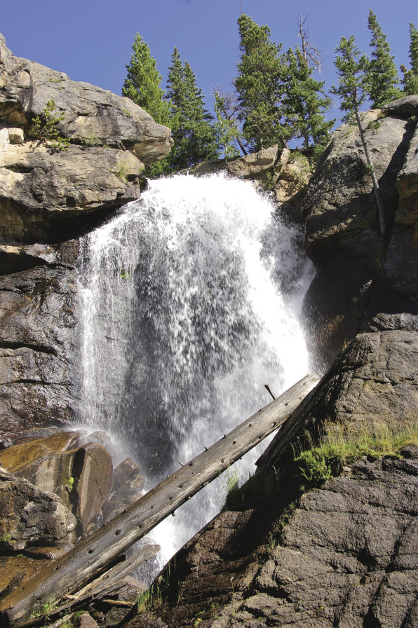
Ouzel Falls
32
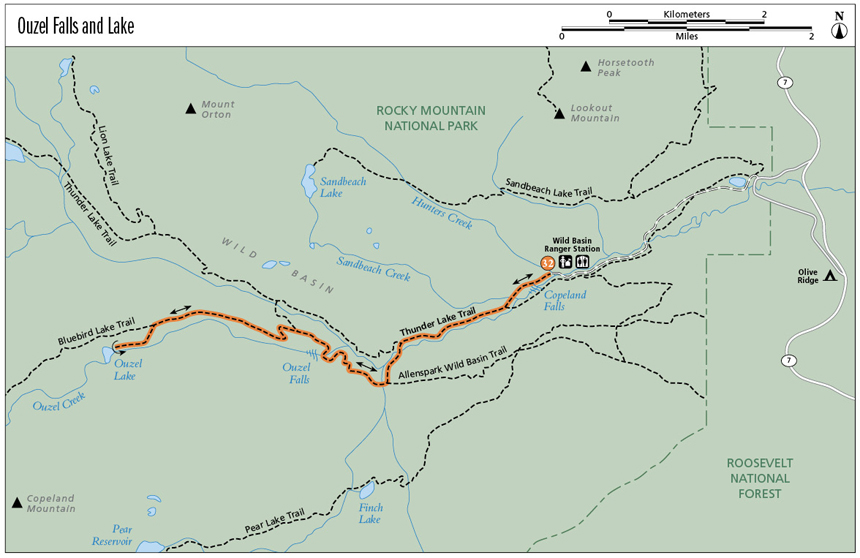
Ouzel Falls and Lake
Wild Basin is a wonderful and somewhat hidden part of Rocky Mountain National Park. You’ll hike along the sparkling, fast-flowing North Saint Vrain Creek and then pass beautiful Calypso Cascades and thundering Ouzel Falls. Beyond Calypso Cascades, nature is regenerating the forest burned in the 1978 fire, which started near Ouzel Lake. The trail offers beautiful views of Longs Peak, Mount Meeker, and the rugged Continental Divide, especially along a ridge lined with ghost trees. Pretty Ouzel Lake lies on a bench not far below treeline. Backcountry campsites are located along or near the trail, with one at Ouzel Lake.
Start: Trailhead near the Wild Basin Ranger Station
Distance: 10.0 miles out and back
Approximate hiking time: 5 hours
Difficulty: Moderate to Ouzel Falls, then Difficult to Ouzel Lake due to distance and elevation gain
Elevation gain: 880 feet to Ouzel Falls; 1,510 feet to Ouzel Lake
Trail surface: Natural surface and rocky trail
Seasons: Best mid-June through mid-Oct
Other trail users: Equestrians
Canine compatibility: Dogs not permitted
Land status: National park wilderness
Fees and permits: Entry fee required. The entrance station is at the start of the road into Wild Basin. Backcountry camping permit (fee charged) required for overnight camping. Food canisters are required for backcountry camping below treeline from May 1 through Oct 31. For information about backcountry camping permits, call (970) 586-1242 or go to www.nps.gov/romo/planyourvisit/backcountry.htm.
Schedule: Open year-round
Maps: USGS Isolation Peak, Allens Park; National Geographic Trails Illustrated 301 Longs Peak/Bear Lake/Wild Basin or 200 Rocky Mountain National Park; Latitude 40˚: Colorado Front Range Trails or Boulder County Trails
Trail contact: Rocky Mountain National Park, 1000 Highway 36, Estes Park; (970) 586-1206, (970) 586-1333 (24-hour recorded message); www.nps.gov/romo
Other: Park only in designated places along Wild Basin Road and in the parking lot.
Special considerations: Some areas of this trail have easy access to water; others do not. The road is closed 1.2 miles from the trailhead in winter. Park in the winter parking lot and cross-country ski or snowshoe to the trailhead. A warming hut is available near the trailhead. The trail is neither marked nor maintained for winter use.
Finding the trailhead: In Boulder, from 28th Street (US 36) and Canyon Boulevard (SH 119), head north on US 36 to its junction with SH 66. Turn left on SH 66 and drive through Lyons to the stop sign at the T intersection (US 36 and SH 7). Turn left onto SH 7 and drive 23.4 miles to the junction with the road to Wild Basin, Boulder County Road 84W. Turn left onto BCR 84W and drive 0.4 mile to the road to Wild Basin/Copeland Lake. Turn right and pay the fee at the entrance station. Drive down the dirt road past Copeland Lake. The road is little more than a car-width wide, so drive carefully. At 1.2 miles past the entrance station, the road forks. Follow the road to the left and cross the bridge. In another 1.0 mile enter the parking lot by the Wild Basin Ranger Station. The trailhead is across the parking lot to the southwest.
The Hike
As you walk along North Saint Vrain Creek and around Calypso Cascades and Ouzel Falls, keep an eye open for a robin-size bird bobbing up and down on a rock in the water. Hopefully you’ll see it dive into the quickly flowing stream to feed. This dark gray bird is the American dipper, or water ouzel. It feeds on aquatic larvae and insects while walking along stream bottoms or dipping its head into the water to catch an unsuspecting yummy tidbit. The bird prefers rushing water, including cascades and waterfalls. Scales cover its nostrils so it doesn’t drown. Ouzel Falls, Ouzel Lake, and Ouzel Peak are named after this interesting bird.
The hike to Ouzel Falls climbs through a typical subalpine forest of Engelmann spruce, subalpine fir, lodgepole pine, low-growing common juniper, the occasional aspen, and many wildflowers. In damper areas ferns grow along the trail. Limber pines join the mix a little higher up, when lodgepole pines reach their elevation limit.
A few hints on tree identification: Spruces have sharp and square needles—you can roll one between your fingers. Fir needles are flat and friendly, and don’t roll. Pine needles are prickly and come in packets. Two lodgepole needles are in each packet. Limber needles come in packets of four or five. Limber pinecones are much larger (3 to 10 inches long) than lodgepole pinecones (less than 2 inches long).
After Calypso Cascades you’ll find an open hillside with ghost trees pointing skywards, while smaller lodgepoles, spruces, aspens, and wildflowers are thriving where the Ouzel Fire swept through over thirty years ago. After the junction with Thunder Lake Trail, Bluebird Lake Trail switchbacks up to the ridge that the fire blazed down. Beautiful views of Ouzel Peak, Mahana Peak, Tanima Peak, and Pilot Mountain can be seen through ghost trees, still reaching to the sky. The forest recovers slowly at this elevation. Some aspens look more like bushes, while limber pines reach about 6 feet tall. Grasses and wildflowers grow profusely between the small trees. Little spruce trees will one day be over 100 feet tall, blocking the view of the mountains like they did before the fire.
Ouzel Falls
On August 13, 1978, a ranger smelled smoke and discovered a small fire burning in duff near a tree obviously struck by lightning. Park personnel considered the location a low-risk zone and let it burn. Fire is part of the natural process, and park policy was to let nature-caused fires burn unless they threatened property. Ten days later the fire was creeping along between Ouzel Lake and Chickadee Pond. Park personnel constantly monitored it. By September 1 high winds caused the fire to take off, and firefighters arrived to contain it. The winds died down, but then unpredicted winds gusted through the area on September 15, sending the fire toward Ouzel Falls and Allenspark to the east. The fire was finally contained within Rocky Mountain National Park at the beginning of October.
One year after the blaze, ferns, grasses, fireweed, and other flowers had reappeared. The second year lodgepole seedlings popped up. Serotinous lodgepole cones are covered with a resin that melts in the heat of a forest fire, releasing seeds. Fires, therefore, renew lodgepole forests. At higher elevations, limber pines often are the first pioneers. Aspen shoots grow quickly from roots underground. Within ten years after the fire, flowers had returned nitrogen to the soil. Aspen sprouts had grown over 12 feet. Dead trees fell, their slowly decaying trunks returning nutrients to the soil. The area now supports a greater variety of vegetation than it did before the fire. Nature recovers.
Miles and Directions
0.0 Start from the Wild Basin Trailhead. Elevation: 8,500 feet. GPS: N40 12.46' / W105 33.96'. In about 200 feet, you enter the Rocky Mountain National Park Wilderness Area.
0.4 Spur trail to the left to Copeland Falls.
1.1 Sunny rock slab along North Saint Vrain Creek. A nice place to sit.
1.3 Junction with trail to Pine Ridge campsite and others. Continue on the main trail to left.
1.8 T intersection with trail to Allenspark. GPS: N40 11.73' / W105 35.39'. Turn right here and continue a few feet to Calypso Cascades.
2.0 Start to walk through the area burned in the Ouzel Fire in 1978.
2.7 Ouzel Falls. Elevation: 9,380 feet. (Elevation gain from trailhead: 880 feet.) GPS: N40 11.92' / W105 35.95'. A privy is available to the right of the trail just before the falls. (Option: For a 5.4-mile out-and-back hike, turn around here and return the way you came.) To reach Ouzel Lake in another 2.3 miles, continue up the trail.
3.0 Trail reaches a Y with Bluebird Lake Trail. Take the left branch to continue to Ouzel Lake. GPS: N40 12.10' / W105 36.17'.
3.4 Trail travels above Ouzel Creek along a ridge that was badly burned in the Ouzel Fire.
4.5 Junction of Ouzel Lake and Bluebird Lake Trails. Turn left here as the trail descends a tad toward Ouzel Creek. GPS: N40 12.14' / W105 37.48'.
5.0 Ouzel Lake. Walk past the outhouse east of the lake and below the designated Ouzel Lake campsite to a set of rocks that are a good lunch spot. Elevation: 10,010 feet. GPS: N40 11.97' / W105 37.87'. Return the way you came.
10.0 Arrive back at the trailhead.
Option
You can hike to Bluebird Lake, which is 1.8 miles beyond the junction of the trail to Ouzel Lake (mile 4.5 above). Elevation: 10,978 feet. GPS: N40 11.32' / W105 39.06'. Strenuous due to 12.0-mile out-and-back length and 2,478-foot elevation gain.
In early June keep an eye open for the delicate Calypso orchids, or fairy slippers (Calypso bulbosa), near Calypso Cascades. These delicate pink to purple flowers with one basal leaf grow in moist, shady places and only in soil where a certain fungus grows.
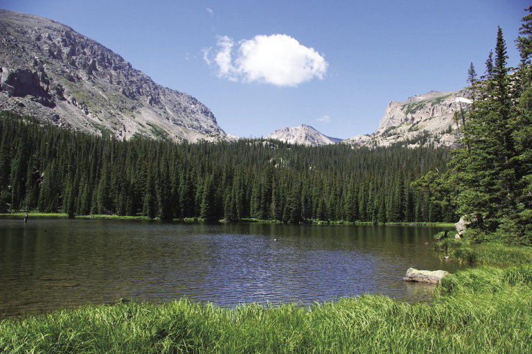
Ouzel Lake
Hike Information
Local Information: Estes Park Convention & Visitors Bureau; (800) 443-7837, (970) 577-9900; www.estesparkcvb.com
Local Events/Attractions: MacGregor Ranch, Estes Park; (970) 586-3749; www.macgregorranch.org
Longs Peak Scottish Irish Festival, Estes Park Convention & Visitors Bureau; (800) 443-7837, (970) 577-9900; www.estesparkcvb.com
Scandinavian Midsummer Festival, Estes Park Convention & Visitors Bureau; (800) 443-7837, (970) 577-9900; www.estesparkcvb.com
Hike Tours: Rocky Mountain National Park Ranger-Led Programs, Estes Park; (970) 586-1206; www.nps.gov/romo
Organizations: Rocky Mountain Nature Association, Estes Park; (970) 586-0108; www.rmna.org