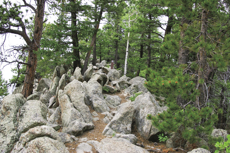
Black Bear Trail through rocks that look like stegosaurus plates
36
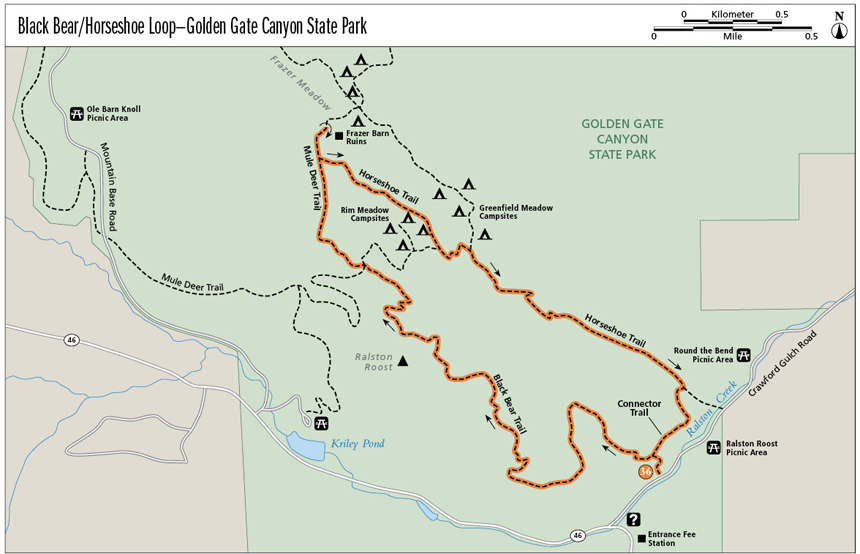
Black Bear/Horseshoe Loop—Golden Gate Canyon State Park
Constant surprises and interesting twists occur along this trail as it climbs up toward Ralston Roost and then drops through an aspen forest and flower-filled meadows. Backcountry sites offer a close-to-home camping opportunity. A side spur takes you to the remains of John Frazer’s barn and the beautiful meadow where he grew vegetables. This area is close to Denver, yet seems so remote while you are hiking here. The rocky ridges around Ralston Roost provide views of the Continental Divide and fun hiking. Different seasons bring new varieties of flowers and colors to the meadows.
Start: Ralston Roost Trailhead
Distance: 5.4-mile loop
Approximate hiking time: 2.5 to 3.5 hours
Difficulty: Difficult due to elevation gain and the rockiness of Black Bear Trail
Elevation gain: 1,370 feet total
Trail surface: Natural surface and rocky trail
Seasons: Best late May through Oct
Other trail users: Hikers only, except for multiple use on Mule Deer Trail
Canine compatibility: Dogs must be on leash
Land status: Colorado state park
Fees and permits: Daily fee or annual state parks pass required. Backcountry camping permit (fee charged) required for overnight camping.
Schedule: Open year-round
Maps: USGS Black Hawk; National Geographic Trails Illustrated 100 Boulder/Golden; Latitude 40˚: Colorado Front Range
Trail contact: Golden Gate Canyon State Park, 92 Crawford Gulch Road, Golden; (303) 582-3707; www.parks.state.co.us/parks/goldengatecanyon
Special considerations: Bring your own water, as little to none is available along the trail.
Finding the trailhead: In Golden, from the mouth of Clear Creek Canyon at the junction of SH 93, SH 58, and US 6, drive north onto SH 93 heading toward Boulder. In 1.3 miles turn left onto Golden Gate Canyon Road. Drive 12.5 miles up Golden Gate Canyon Road (ignore all side roads) to the entrance fee station on the right and pay the daily fee. In 0.1 mile turn right onto Crawford Gulch Road. The Golden Gate State Park Visitor Center is 0.1 mile on the right and has restrooms and water. The Ralston Roost Trailhead is 0.2 mile past the visitor center on Crawford Gulch Road. Parking lots are on both the left and right sides of the road. No facilities are available at the trailhead.
The Hike
In 1850 Lewis Ralston headed through Kansas Territory to the California goldfields. At a campsite in present-day Arvada, he found gold flakes in his pan in a creek that now bears his name. Some miners, disappointed by their luck in California, returned to Kansas Territory, remembering Ralston’s discovery. One group found gold near the confluence of Cherry Creek and the South Platte, and some group members then headed west.
In 1859 John H. Gregory started systematically panning for gold in Clear Creek and its tributaries. In a gulch west of North Clear Creek he found a lode of gold, not just flakes in a creek. Gregory’s Diggings were located on the border between today’s Central City and Black Hawk. In those days, roads were few and far between. The Gregory Toll Road was built from Golden to Gregory’s Diggings. Much of Golden Gate Canyon Road follows this old route.
Not everyone liked the rough mining life. A few people realized miners needed food and wood, and around Ralston Creek they found suitable land to raise vegetables and cut lumber to sell to the miners. One such person was John Frazer, whose barn remains you’ll see on this hike. An interpretive sign describes his life from 1868 to 1896.
Black Bear Trail through rocks that look like stegosaurus plates
In 1920 Charles Greenfield moved his family to a 320-acre homestead near a spring and an intermittent brook east and downstream of Frazer’s homestead. He built a three-room log cabin near the spring for his wife and three children, and later a cow barn with hayloft, a horse barn, a chicken coop, and an icehouse. The forested acreage became pasture and a firewood source. The family cleared about 20 acres for crops on soil Greenfield thought would best produce, but the short summers at 9,000 feet limited what could be grown. Area farmers typically grew potatoes, rutabagas, turnips, lettuce, peas, hay, barley, and oats. The Greenfields raised a few cows, horses, a pig, and some chickens. Rabbits and grouse often ended up on the dinner table accompanied by potatoes. Deer and elk were seldom seen, their population decimated for food for the mining camps. The farm animals provided eggs, cream, and milk.
Any produce that the family didn’t need was taken to a neighboring house 2 miles away on Golden Gate Canyon Road. These neighbors, the Bohees, then drove to Golden and Denver to sell the local produce. Money earned purchased flour, kerosene, and other necessities. Greenfield’s wife, Clara, also made cottage cheese and cream puffs, which she sold to restaurants in Central City.
This hike starts on Black Bear Trail, which provides a surprise at every curve as it wends its way up a ridge of rock outcroppings toward Ralston Roost. Occasionally the Continental Divide comes into view between lodgepole pines. In places the trail takes you up rock slabs or ledges with good places for feet and hands. Watch for trail posts that show the way. Stickers on the Black Bear Trail posts have a black bear paw on them with black bear printed below.
Heading down from the top viewpoint, you’ll walk along a narrow rocky ridge reminiscent of a stegosaurus’s back. Along Mule Deer Trail and Horseshoe Trail, colorful wildflowers bloom profusely in the meadows and aspen groves glow brilliant gold in fall. Horseshoe Trail occasionally crosses the old road that accessed the Greenfield homestead. Not far off Horseshoe Trail, you can camp overnight at Rim Meadows or Greenfield Meadows campsites. A great way to experience the beauty of this land is to hike during different seasons.
Miles and Directions
0.0 Start from the Ralston Roost Trailhead. Hike up Black Bear Trail. Elevation: 8,200 feet. GPS: N39 49.98' / W105 24.49'.
0.1 Junction of Black Bear Trail with connecting trail to Horseshoe Trail. Continue straight (a tad left) up Black Bear Trail.
0.75 Trail sign says to follow trail markers through rock outcroppings ahead. The trail is well-marked and does cross a number of rocky stretches. The craggy rocks of Ralston Roost appear as you twist and turn up the trail.
2.0 The trail climbs through some slanty rock faces, so keep an eye open for the trail markers. At the top of the rocky trail, look a few feet off the trail to the left for a good view of the Continental Divide and Ralston Roost from a rocky outcropping. Elevation: 9,480 feet. GPS: N39 50.38' / W105 25.42'.
2.1 The trail follows a narrow ridge with upstanding rocks, like the plates on a stegosaurus’s back. From here the trail drops steadily through some rocky sections, then through a lodgepole pine, Douglas fir, and aspen forest.
2.5 Junction with trail to Rim Meadow campsites. Stay on the trail to the left and you’ll intersect Mule Deer Trail in about 50 feet. Turn right onto Mule Deer. GPS: N39 50.56' / W105 25.56'. This section of trail is open to mountain bikers, equestrians, and hikers.
3.0 Junction of Mule Deer and Horseshoe Trails. Continue straight ahead on Mule Deer to Frazer Meadow and remains of the Frazer barn.
3.1 Interpretive sign by the old barn remains in Frazer Meadow. Elevation: 9,040 feet. GPS: N39 50.95' / W105 25.69'. Once you’ve finished reading and exploring, return the way you came to the junction with Horseshoe Trail (mile 3.0).
3.2 Junction of Mule Deer and Horseshoe Trails. Turn left onto Horseshoe and head downhill through aspens and flower-filled meadows. Horseshoe Trail is hiker only.
3.8 Junction with trail to Rim Meadow campsites. Continue straight ahead on Horseshoe Trail.
3.95 Junction with trail to Greenfield Meadow campsites. Continue straight ahead on Horseshoe Trail.
5.0 Junction of Horseshoe Trail and the connecting trail to Black Bear Trail. Turn right here and cross the little creek, then head up the ridge. GPS: N39 50.22' / W105 24.39'.
5.3 Junction with Black Bear Trail and connecting trail to Horseshoe Trail. Turn left and head downhill on Black Bear Trail.
5.4 Arrive back at the trailhead.
Option
For a shorter, moderate, 4.6-mile out-and-back hike to Frazer Meadow, turn right at mile 0.1 and hike over to Horseshoe Trail. Turn left onto Horseshoe and hike to Mule Deer Trail. Turn right to the interpretive sign by the Frazer barn. This hike is mile 3.1 to mile 5.4 above in reverse. Return the way you came.
Green Tip:
Never let your dog chase wildlife. It is illegal in Colorado for dogs to chase or harass wildlife, including chipmunks and squirrels.
Hike Information
Local Information: Greater Golden Chamber of Commerce, Golden; (303) 279-3113; www.goldenchamber.org
Gilpin Historical Society, Central City; (303) 582-5283; www.gilpinhistory.org
Local Events/Attractions: Colorado Railroad Museum, Golden; (800) 365-6263, (303) 279-4591; www.crrm.org
Central City Opera House, Central City; (303)292-6700, (800) 851-8175; www.centralcityopera.org
Organizations: Friends of Golden Gate Canyon State Park, Golden; (303) 582-3707
The Foundation for Colorado State Parks, Denver; (303) 455-7109; www.parks.state.co.us/foundation