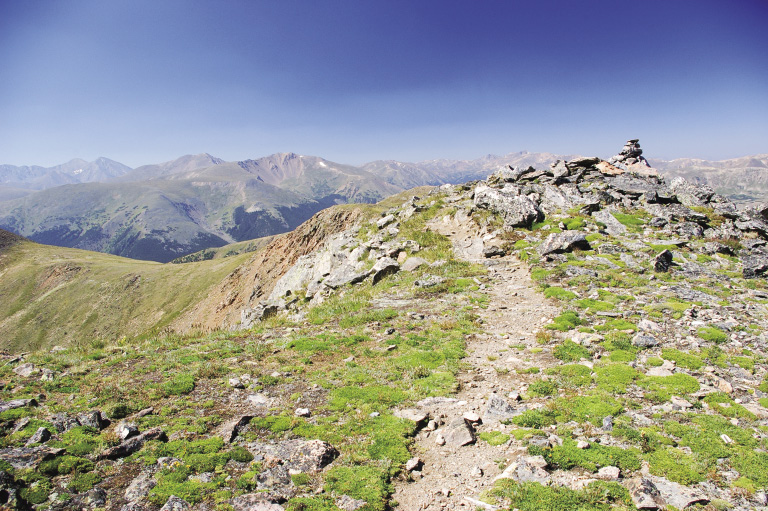
Cairn on Mount Flora Trail at mile 2.7
38
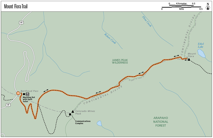
Mount Flora Trail
The relatively gentle “climb” of 13,132-foot Mount Flora along the Mount Flora Trail section of the Continental Divide National Scenic Trail passes through the old Berthoud Pass Ski Area then into the “Land Above the Trees.” The trail wanders in and out of the James Peak Wilderness. The miniature world of the alpine tundra will dazzle you with a carpet of tiny, colorful wildflowers surviving in a harsh place. The 360-degree views from Mount Flora’s summit range from the expansive flatness of the eastern plains, to valleys with beautiful alpine lakes, to peaks as far as you can see.
Start: Big Continental Divide Trail kiosk in the parking lot at the east side of Berthoud Pass summit
Distance: 6.4 miles out and back
Approximate hiking time: 2.5 to 3.5 hours
Difficulty: Most Difficult due to elevation gain and altitude
Elevation gain: 1,817 feet
Trail surface: Dirt road (closed to the motorized public), and natural surface and rocky trail
Seasons: Late June through early Oct
Other trail users: Equestrians; mountain bikers on road only
Canine compatibility: Dogs must be on leash
Land status: National forest wilderness
Fees and permits: None required
Schedule: Open year-round
Maps: USGS Berthoud Pass and Empire; National Geographic Trails Illustrated 104 Idaho Springs/Loveland Pass; Latitude 40°: Colorado Front Range Trails
Trail contacts: Arapaho National Forest, Clear Creek Ranger District, 101 Chicago Creek Road, Idaho Springs; (303) 567-3000; www.fs.fed.us/r2/arnf. James Peak Wilderness Fact Sheet available at www.wilderness.net; click on Find a Wilderness, and List by Name to select “J” then James Peak Wilderness.
Other: Please stay on Mines Peak Road and do not bushwack up the open ski slopes. Be careful when walking on the trail across the alpine tundra—the plants are very fragile. They must grow, bloom, and reproduce in about six short weeks of summer. When the same plant is trampled by many boots, it dies.
Special considerations: This trail takes you above treeline, with danger of lightning from thunderstorms. Bring extra warm clothes, including gloves. The ever-present wind gets mighty chilly above treeline, even in summer. This area is prone to avalanches in winter. The trail is neither marked nor maintained for winter use. The James Peak Wilderness limits group size to 12 people and stock combined; campfires are prohibited. Follow Leave No Trace techniques on this trail. Bring plenty of water, as little to none is found on the trail.
Finding the trailhead: From I-70, exit 232, US 40/West Empire and Granby, drive 14.4 miles west on US 40 to the top of Berthoud Pass and the Berthoud Pass Trailhead. You’ll pass through Empire on the way. Turn right (east) and park in the parking lot. A warming hut with vault restrooms is located at the north end of the parking lot. The trail starts at the Continental Divide Trail kiosk near the warming hut and behind the berthoud pass sign.
The Hike
Heading up Mount Flora Trail on Mines Peak Road (FR 239) gives you a chance to chat with your buddies and wake up. The road leads to the communications complex at the top of Colorado Mines Peak (12,493 feet). On the north side of Mines Peak Road is part of the old Berthoud Pass Ski Area, which opened in 1937. One of the first major ski areas in Colorado, an 848-foot rope tow powered by a V-8 engine moved skiers uphill. In 1947 the area boasted the first double chairlift in the state. The base lodge at the top of the pass contained a ski shop, restaurant, and cafeteria, and it remained open during the summer for tourists.
A series of misfortunes befell the ski area in 1988 and 1991, resulting in the owners filing for bankruptcy. The area reopened in January 1998, but by 2001 it could no longer compete with the larger resorts. It remained open as a powder cat operation for a couple of years, but in 2003 the owners decided to end operations and removed the ski lifts that summer. They demolished the base lodge and rehabilitated the site in 2005.
This section of the Continental Divide National Scenic Trail (CDNST) is named Mount Flora Trail. When you come to the fourth switchback on the road going up Colorado Mines Peak, look straight ahead to see the trail sign at the lip of the road. Once on the single-track CDNST, you’ll contour around the peak through spruce-fir forest. Near the trail sign are some of the old concrete footings for a chairlift. As the trail curves to the east, it climbs steadily through the ecotone where subalpine forest and alpine tundra meet. The trees grow sparser and smaller in this exposed land where the winds blow harder, creating lower temperatures. The mean summer temperature is usually less than 50˚F. Speaking of wind, a chilly breeze often blows over these high spaces, and rare is the day when you can sit on the summit without wearing a jacket.
Cairn on Mount Flora Trail at mile 2.7
Finally you are in the land above the trees, with its miniature plants and flowers that somehow survive a summer that may only last for six weeks. The flowers bloom brilliantly after the Fourth of July. Perhaps the carpet of teeny flowers gave Mount Flora its name. Patches of blue forget-me-nots grow along the trail, accompanied by grayish green stalks of alpine sage, the bright yellow of alpine avens and cinquefoil, pink moss campion, white alpine phlox, yellow paintbrush, and bistort. Plants such as the moss campion grow in cushions for protection against wind and ice particles. Their taproots may reach 4 to 5 feet underground to find moisture and anchor against the winds. The moss campion grows slowly—about a quarter inch a year. The big golden sunflowers that tower over the smaller plants are old-man-of-the-mountain. These “giants” take several years to gather and store enough energy to bloom. Once the flower fades away, the plant dies.
For all their apparent toughness, alpine plants are quite fragile. Frequent trampling by boots can destroy them. A piece of paper covering a small cushion plant may deny it the energy needed to make it through the winter. Please stay on the trail. If you do need to walk across alpine tundra, do so on rocks as much as possible, and spread your group out so no two footsteps land on the same plant.
Past the saddle at mile 1.6, the trail meanders in and out of the James Peak Wilderness. Mount Flora’s summit is in this wilderness area.
Miles and Directions
0.0 Start from the Continental Divide Trail kiosk near the warming hut at the northeast end of the parking lot at the east side of Berthoud Pass summit. The trail starts here and traverses the slope above the parking lot. Elevation: 11,315 feet. GPS: N39 47.90' / W105 46.52'.
380 feet The trail merges with Mines Peak Road (Forest Road 239). Turn left and walk up the dirt road.
0.85 As you approach the fourth switchback (curves to the right), look straight ahead to find the CDNST sign. The hike continues on the single-track trail. GPS: N39 47.80' / W105 46.29'.
1.6 The trail reaches a saddle, then starts climbing the ridge of the Continental Divide.
2.7 The trail climbs a little boulder bump. Look to the right for stone steps and a cairn as you head up the boulders.
3.2 The summit of Mount Flora, which is flat enough that it’s hard to determine the top. Look to your left for a rock-wall shelter, especially if it’s windy. You are in the James Peak Wilderness. Elevation: 13,132 feet. Rock shelter at N39 48.29' / W105 44.10'. Return the way you came.
6.4 Arrive back at the trailhead.
Hike Information
Local Information: Clear Creek County Chamber & Tourism Bureau, Idaho Springs; (303) 567-4660, (866) 674-9237; www.clearcreekcounty.org
Local Events/Attractions: Argo Gold Mill, Idaho Springs; (303) 567-2421; www.historicargotours.com
Indian Hot Springs, Idaho Springs; (303) 989-6666; www.indianspringsresort.com
Organizations: Continental Divide Trail Alliance, Pine; (888) 909-CDTA, (303) 838-3760; www.cdtrail.org
Continental Divide Trail Society, Baltimore, MD; (410) 235-9610; www.cdtsociety.org
Indian Peaks Wilderness Alliance, Boulder; www.indianpeakswilderness.org
Green Tip:
Recycle your old gear by giving it to someone or an organization that will reuse it.
Charles Christopher Parry, an eminent botanist in the late 1800s, named Mount Flora, perhaps for the alpine wildflowers, his favorite. In summer 1861 he collected over 417 species of plants in Colorado. He also named Grays Peak and Torreys Peak after his contemporaries, botanists Asa Gray and John Torrey.