1 Quiet Walkways
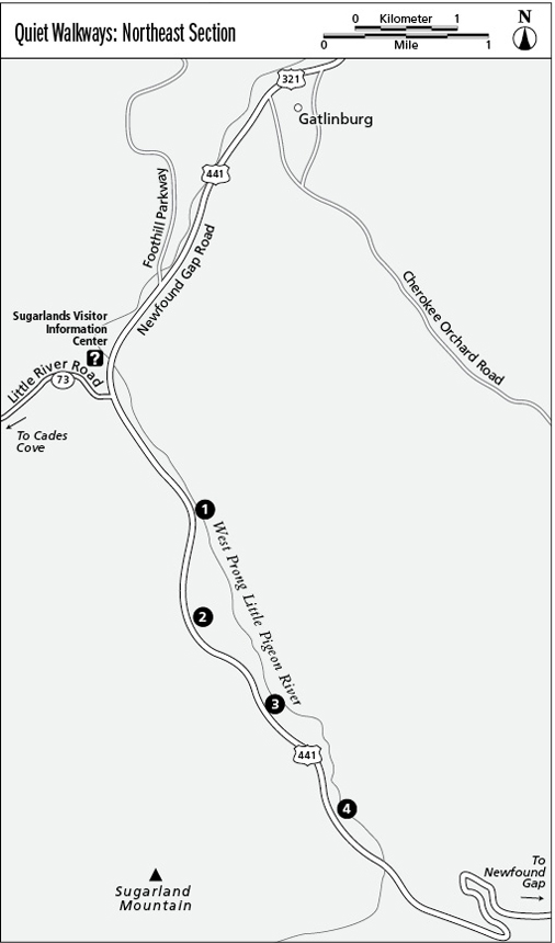
The Smokies’ “Quiet Walkways” are great offerings—short strolls through sylvan settings along the Newfound Gap Road and in other places. They lead to very easy glimpses of nature and are often less busy than trails to specific points of interest. Some tie in to existing trails but most are segments of now-interrupted valley roads used by early settlers or loggers. These paths invite motorists to get out of their cars and stretch their legs. There are four along Newfound Gap Road between the Sugarlands Visitor Center and Newfound Gap.
Distance: Short out-and-back strolls; up to 0.5 mile.
Approximate hiking time: 30 minutes each, unless you dawdle
Trail surface: Usually flat and firm, sometimes grassy
Other trail users: None; no dogs or horses allowed
Best season: Year-round except when covered in snow or ice
Canine compatibility: Dogs not permitted
Fees and permits: None
Schedule: Closed only when inclement weather closes Newfound Gap Road
Trail contacts: Information about trails, camping, road closures, as well as downloadable maps and a “Smokies Trip Planner” are available online under the “Plan Your Visit” part of the park’s excellent Web site, www.nps.gov/grsm. The Backcountry Information Office is open 9 a.m. to noon, 865-436-1297.
Finding the trailhead: Traveling south from Sugarlands Visitor Center, these paths are located on the left (east) at 1 mile, 1.7 miles, 2.3 miles, and 3.2 miles. Most are marked by small QUIET WALKWAY signs at the parking turnouts.
The Hike
The first Quiet Walkway (at 1 mile) explores a setting similar to the Sugarlands Nature Trail without the pavement or people. Bear right near the river to reach a nicely intact portion of the old valley road.
The walkway at 1.7 miles has handicapped parking and leads down a gradual old road grade to a bench where the Little Pigeon River is visible below (this is a favorite for fishing).
The walkway at 2.3 miles descends steeper switchbacks to the river and offers a rock-delineated section of the old road and evidence of early farming and settlement.
The walkway at 3.2 miles forms a little loop. Dip down the graveled path and go right above the river along a spectacular stone wall. At a gap in the wall, go left to the river and back to close the loop by hiking up past a bench.