5 Ramsay Cascades
Reaching one of the Smokies’ highest and most scenic waterfalls requires a long but not too taxing day hike. The trip into this well-watered, rhododendron-rich watershed is made all the more special by one of the park’s most impressive big forests.
Distance: 8 miles out and back
Approximate hiking time: 4 to 5 hours
Trail surface: Starts on a old forest road then becomes a wooded trail with rocks, roots, muddy spots, and a rocky scramble at the end
Other trail users: None; no dogs or horses allowed
Best season: Best in spring for flowers, and for the falls after a rainy spell
Canine compatibility: Dogs not permitted
Fees and permits: None
Schedule: Significant winter snow could restrict access
Maps: USGS Mount Guyot; TOPO! Tennessee, Kentucky
Trail contacts: Information about trails, camping, road closures, as well as downloadable maps and a “Smokies Trip Planner” are available online under the “Plan Your Visit” part of the park’s excellent Web site, www.nps.gov/grsm. The Backcountry Information Office is open 9 a.m. to noon, 865-436-1297.
Special considerations: The Smokies are notorious for fatalities at waterfalls. Do not be tempted to climb this or any Smokies cascade.
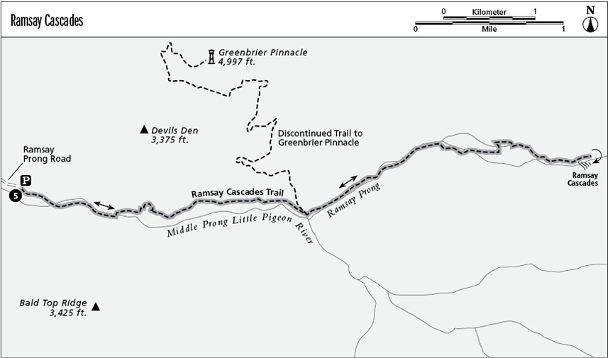
Finding the trailhead: Leave Gatlinburg with a turn from US 441 onto eastbound US 321 at stoplight #3. In 6 miles, turn right (south) into the national park on Greenbrier Road. The road goes gravel beyond the Greenbrier Ranger Station where, at 3 miles, you turn left (east) at the fork. Continue for another 1.5 miles to the trailhead. GPS: N35 42 10.290' / W83 21.417'
The Hike
Ramsay Cascades must have an identity crisis. Over the years it’s been consistently spelled inconsistently, with either “sey” or a “say” at the end. Southern Appalachian family names had a way of evolving over time—this is another example.
The 1.5 miles, on a very gradual forest road, makes a nice stroll without going all the way to the waterfall. The long bridge not far from the trailhead is another of those great Smokies opportunities to snag a photo from the middle of a rushing, wild stream amidst lush rhododendron (the Boogerman Trail offers another such opportunity, also not far from the road).
Past the end of the dirt road, the route explores increasingly deep woods as the trail follows the Middle Prong of the Little Pigeon River. You’ll cross a bridge at just more than 2 miles, then follow Ramsay Prong through dense, rich rhododendron forests that rise left (north) up to Greenbrier Pinnacle and right (south) up to Guyot Spur. This route though impressively towering trees delves deep into a cleft that runs all the way up to the Smokies’ crest and Mount Guyot (6,621 feet), the fourth highest peak in eastern America—second highest in the park and the highest mountain in the East that does not have a formal trail to its summit.
At 3 miles, cross a bridge to the left (north) bank of Ramsay Prong, and for the next 0.7 mile walk through an inspiring cove hardwood forest in an area that escaped the logger’s saw. Big poplars dominate the forest. The final few tenths of a mile to the waterfall is steep, rocky, and wet, so prepare to take it easy and watch your footing. This waterfall is worth the effort.
Miles and Directions
0.0 Start on a gradual forest road.
1.5 Leave the dirt road on a woodsy trail.
3.0 Cross the last big bridge to the north side of Ramsay Prong.
4.0 Reach Ramsay Cascades.
8.0 Arrive back at the trailhead.