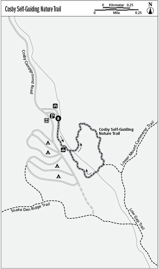
8 Cosby Self-Guiding Nature Trail
This trail is much more than a campground leg-stretcher. The designer of this trail must have been an artist. The way the trail offers up the virgin forest experience is almost as impressive as the setting itself.
Distance: 1-mile loop
Approximate hiking time: 1 hour plus
Trail surface: Packed soil or gravel with some rocky sections and old asphalt
Other trail users: None; no dogs or horses allowed
Best season: Year-round
Canine compatibility: Dogs not permitted
Fees and permits: None
Schedule: Significant winter snow could restrict access.
Maps: USGS Hartford; TOPO! Tennessee, Kentucky
Trail contacts: Information about trails, camping, road closures, as well as downloadable maps and a “Smokies Trip Planner” are available online under the “Plan Your Visit” part of the park’s excellent Web site, www.nps.gov/grsm. The Backcountry Information Office is open 9 a.m. to noon, 865-436-1297.
Special considerations: This trail is so nice that you might consider camping at Cosby Campground just to take this hike. Further, consider that a vastly improved Cosby Campground reopened in spring 2010, making it one of the best maintained campgrounds in the park. Stimulus funding repaved the campground for the first time since the 1960s and made other facility improvements possible.
Finding the trailhead: From the US 321/TN 32 junction, about 15.4 miles east of Gatlinburg, turn right (southeast) and drive 1.2 miles. Turn right (south) again on the signed Cosby Campground road. Drive 2 miles and take the first left into the picnic area as you approach the campground. Swing along past the picnic sites (where restrooms and water are available seasonally) and up to the right into the hikers’ parking area, just below the campground entrance kiosk. GPS: N35 45.361' / W83 12.475'
The Hike
This amble not far from the drainage of Crying Creek is so scenic it could almost bring tears to your eyes. Drop past the mileage sign to an atmospheric old road grade and go right (south) on the Low Gap Trail, following the nature trail sign. Fine views look down onto the rushing stream in a mature cove hardwood forest. Pass the side trail on the right to the amphitheater parking area (actually the “formal” start of the nature trail, where the trail brochure is available at a trailhead dispenser). Continue below the nicely refurbished amphitheater to cross a ford on the old road at the trail’s first numbered post.
Go left (east) past the ford to cross two log bridges and wander down between streams in a tall forest alive with water. This is the inspiring grove you were earlier looking down upon—a richly tangled virgin forest lush with ferns and moss. Also notice the extensive growths of partridgeberry that thrives along this trail. The plant (with many medicinal uses for Native Americans) flowers in early spring (with twin blossoms) and enlivens a winter hike with mats of small evergreen leaves and red autumn berries that feed wildlife throughout the cold season.
As you wander down and to the right among wet and dry drainages, old remnants of asphalt paving crop up. On the left, past post #4, sits a startlingly intertwined maple and birch—both germinated atop a fallen log that long ago decayed, leaving them standing on stiltlike roots. More streams appear to the right (east) and the trail crosses two more bridges. Turning uphill, there’s a trailside view of a little pool and cascade. Wandering higher between streams, amid a truly impressive cathedral of trees, the trail crosses another log bridge. There’s no numbered post here, but if there were one it’d be labeled “Fallen Giant” in the trail brochure. A mammoth uprooted hardwood lies directly across the trail, nicely sawed to permit passage. The rushing stream pouring past its shallow roots—and high wind or ice?—spelled this tree’s demise. At post #8, a rock-wall enclosure sits to the left and a fallen chimney scatters to the right. Beyond, the trail follows a moss-covered stone wall that also leads to a stream on the right. Imagine living in such a place.
At a T junction with the Low Gap Trail, go right (west), across two log bridges to the old road grade you started on. Turn right, descending past the amphitheater to the trailhead.
Miles and Directions
0.0 Start on the old road grade.
0.2 Turn left (northeast) from the old road onto the nature trail.
0.7 Turn right (southwest) at the junction with the Low Gap Trail.
1.0 Arrive back at the trailhead.