10 Oconaluftee River Trail/Mountain Farm Museum
The Mountain Farm Museum may just be a stroll, but combine it with one of the Smokies’ best kept secret easy walks, the Oconaluftee River Trail, and you have one of the park’s best combinations of scenery and interpretation. It is a masterful meshing of insight into Native Americans and later settlers.
Distance: Up to 3 miles out and back from the Oconaluftee Visitor Center to Cherokee, with shorter out-and-back options from Newfound Gap Road trailheads to the Mountain Farm Museum and a shuttle option from Ocanaluftee Visitor Center to Cherokee
Approximate hiking time: 2 hours with 30-minute shortcut options or 1 hour shuttle
Trail surface: Grassy at Mountain Farm, lightly graveled road-width path
Other trail users: This is one of the very few trails in the Smokies where dogs and bikes are permitted
Best season: Year-round
Canine compatibility: Dogs are permitted on the Oconaluftee River Trail while on leash—but no dogs are allowed in the Mountain Farm Museum enclosure
Fees and permits: None
Schedule: Year-round. Even when inclement weather closes Newfound Gap Road, this trail can be hiked from the Cherokee trailhead.
Maps: USGS Smokemont and Whittier; TOPO! North Carolina, South Carolina
Trail contacts: Information about trails, camping, road closures, as well as downloadable maps and a “Smokies Trip Planner” are available online under the “Plan Your Visit” part of the park’s excellent Web site, www.nps.gov/grsm. The Backcountry Information Office is open 9 a.m. to noon, 865-436-1297.
Special considerations: This hike can be started from a variety of trailheads, making it customizable for different distances and fitness levels.
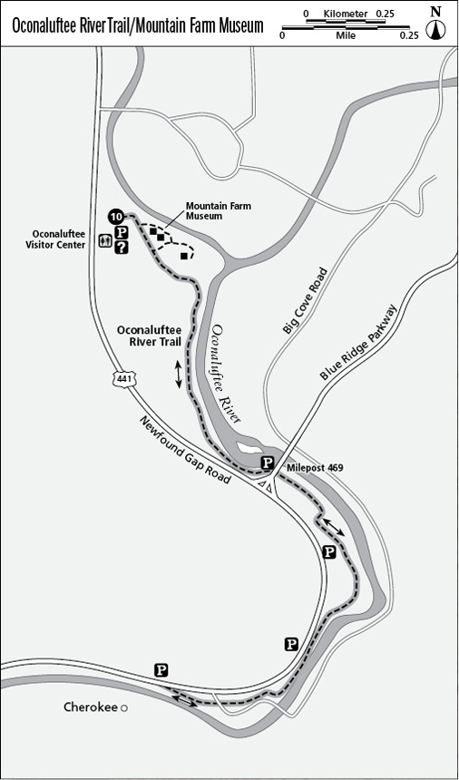
Finding the trailhead: Park at the Oconaluftee Visitor Center (where restrooms and water are available), at the Cherokee Transit parking area in Cherokee, or at any of three pull-offs between Cherokee and the Oconaluftee Visitor Center on the right side of Newfound Gap Road. From the park boundary at Cherokee, those parking spots are located at 0.3 mile (a turnout at the park entrance sign), 0.5 mile (a parking pull-off), and at 0.7 mile there’s a single car parking spot at the start of the Blue Ridge Parkway. To reach that, turn right/northeast from Newfound Gap Road onto the Parkway, turn around at the first overlook, and on the way back to Newfound Gap Road, pull off the Parkway to the right onto roadside gravel just across the bridge from milepost 469. Ocanaluftee Visitor Center trailhead GPS: N35 30.786' / W83 18.398'
The Hike
If you’ve ever wondered what a hog does when an overspreading oak drops a September acorn into its artfully sited sty, this trail can answer that question.
I may be overly fond of this path, in part because the route suggested combines two separate experiences that aren’t linked in other trail publications.
The Mountain Farm Museum is a flat, 0.5-mile wander among a stunning collection of nineteenth-century backcountry farm structures that paint a vivid picture of a settler’s life, complete with chickens crowing and pigs grunting. The Oconaluftee River Trail (ORT) leads from the farm to Cherokee—or from Cherokee to the farm. Hiking either way offers a major dose of riverside scenery along with what may be the park’s best insight into Cherokee Indian culture. A half dozen interpretive plaques on the trail explain Cherokee beliefs and respect for the natural world (in English and Cherokee). The signs include evocative illustrations by Cherokee artists that will make you want to visit the tribe’s Qualla Arts and Crafts gallery in town. There’s a bench at each sign and at other places along the path.
Above the visitor center the river flows narrow and fast along Newfound Gap Road, but along the ORT, the Oconaluftee spreads wide and dances over ledges and around islands. The river starts in one of the East’s biggest wilderness areas and the refreshing clean smell of the water matches the emerald green color in a way that defies verbal description.
All along the river there’s an open understory of grasses and ferns with many wildflowers, including bee balm and entire trailside borders of jewelweed or touch-me-not (in late August).
One reason the ORT is a good family hike for visitors is that it’s very popular with Cherokees as a place to jog or stroll with family. Seeing local Native Americans enjoying their ancestral homeland while you pause to read interpretive signs about Cherokee legend is a rich experience you won’t get by stopping at the Bear Trap souvenir shop.
Leave the visitor center’s south side and the trail splits; go left (east) to the Mountain Farm Museum and right (southeast) to the Oconaluftee River Trail that skirts the farm. Explore the farm first—the interpretive signs that explain the structures, all gathered in 1950 from throughout the Smokies, also picture many in their original locations. After you’ve toured the farm, exit past the Apple House near the cornfield and turn left (southeast) on the ORT. The trail follows the farm’s fence line, then swings close to the river at the first Cherokee cultural sign.
At 0.7 mile the trail goes under the Blue Ridge Parkway bridge and side steps lead right (south) to a roadside parking slip (one of three places to park along the ORT that permit shorter out-and-back hikes from the roadside to the Mountain Farm Museum and back—the reverse of the direction described here). The trail swings away from the river and at 0.9 mile crosses a small bridge where a right (west) turn up the rooty bank just beyond leads to the second roadside trailhead, this one a designated parking area on Newfound Gap Road. At 1.2 miles from the Mountain Farm Museum, a rock wall leads right (west) to the next roadside trailhead at the park’s major entrance sign (the first parking spot reached from Cherokee). The trail then crosses Big Cove Road at 1.3 miles and reaches the sidewalks of Cherokee across from the Cherokee Transit parking area at the reservation boundary at 1.5 miles.
By the way—when the acorn drops into the pig sty, the pig trots right to it!
Options
If you don’t want to start at the visitor center, choose the roadside parking area that’s right for you and hike out-and-back to the Mountain Farm Museum. From the Cherokee Transit lot the round-trip hike to the museum is 3 miles (the same distance as from the visitor center to Cherokee and back). The round-trip hike to the museum is 2.4 miles from the park entrance sign lot, 1.8 miles from the parking area near the trail bridge (immediately before the sign blue ridge parkway next right), and 1.4 miles from the roadside slip at the start of the Blue Ridge Parkway (see “Finding the trailhead” for road directions). From all of these starting points, you begin with Cherokee culture, in a scenic, natural setting, and end with the newcomers.
Want to have the entire experience with half the round-trip distance? Leave your car at the Cherokee Transit parking area (directly across from the Oconaluftee River Trailhead in Cherokee) and take the shuttle that runs between Cherokee and Gatlinburg/Pigeon Forge. Get off at the Oconaluftee Visitor Center. The shuttle runs many times daily from May through October (a fee is charged). Stroll through the museum then walk back to your car for a 1.5-mile one-way hike.
Miles and Directions
0.0 Start at the Oconaluftee Visitor Center.
0.7 Pass side steps to the Blue Ridge Parkway.
1.2 Pass the park entrance sign.
1.5 Reach the Cherokee Transit parking area and turnaround point.
3.0 Arrive back at the trailhead at the Oconaluftee Visitor Center.