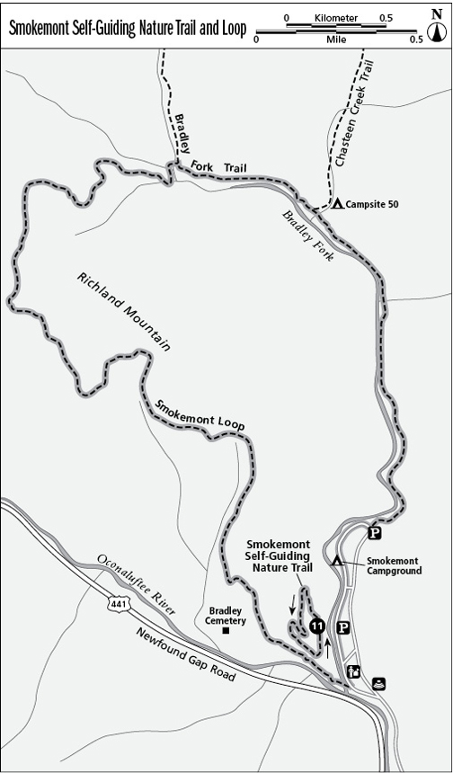
11 Smokemont Self-Guiding Nature Trail/Smokemont Loop
One of the park’s steeper nature trails rises above Smokemont Campground, site of one of the Smokies’ biggest early twentieth-century logging operations. A few longer options include a loop and a very easy overnighter for beginner backpackers.
Distance: 0.75-mile lollipop loop (nature trail); 6.1-mile loop; 3.6-mile backpacking option
Approximate hiking time: 30 minutes for the nature trail, 3 hours for the loop
Trail surface: Packed clay soil surface, with a very rooty upper section for the nature trail. For the loop, the hike starts on a gravel road and ends on a steeper forest trail.
Other trail users: The Bradley Fork Trail, Chasteen Creek Trail, and campsite 50 are open to equestrian traffic.
Best season: Spring for wildflowers (on the loop)
Canine compatibility: Dogs not permitted
Fees and permits: None
Schedule: Closed only when inclement weather closes Newfound Gap Road. Smokemont Campground is open year-round.
Maps: USGS Smokemont; TOPO! North Carolina, South Carolina
Trail contacts: Information about trails, camping, road closures, as well as downloadable maps and a “Smokies Trip Planner” are available online under the “Plan Your Visit” part of the park’s >excellent Web site, www.nps.gov/grsm. The Backcountry Information Office is open 9 a.m. to noon, 865-436-1297. To reserve campsite 50, call the Backcountry Reservation Office (open 8 a.m. to 6 p.m.; 865-436-1231) a month in advance of your first planned day on the trail.
Special considerations: You’ll need to reserve a spot in advance at campsite 50 if you plan to do the optional 3.6-mile out-and-back backpacking trip.
Finding the trailhead: From Newfound Gap Road turn right (north) into Smokemont Campground, located 3.2 miles north of Oconaluftee Visitor Center. Cross the river bridge to the T junction and go left. Pass the campground check-in kiosk and not far beyond, turn left and park on the right opposite campsites B31 and B32 (restrooms are available just beyond, on the left, by Campsite B36). To reach the start of the Smokemont Loop, either pass the nature trail and park on the right at an old bridge, or drive farther into the campground and where the D loop splits, take the left fork for sites D20 to D45. Park at the end of the loop near Campsite D32 at the BRADLEY FORK TRAIL sign (restrooms are available near Campsite D29 just south of the trailhead). When you finish the loop hike, you’ll need to walk back through the campground to wherever you parked. In winter, with D loop and its restroom closed, the recommended parking spot is near the nature trail at the old bridge, not far from watchful ranger offices near the campground entrance. Nature trail trailhead GPS: N35 33.465' / W83 18.742'
The Hike
The Smokemont Nature Trail starts at a roadside sign and crosses three single log bridges that impart a deep woods Smokies feel. The second bridge spans lively, cacophonous Bradley Fork, and the third crosses a silent, lazy side flow that could almost be another creek in a completely different place. Beyond, the trail slams into a sharp hillside and splits, each side rising steeply to wrap around the knob above.
Go right (north) and the trail undulates up along a very steep side hill overlooking the campground. No flat little loop this: You’re immediately up and out of the campground in a place that’s suddenly not so tame. An irony, given that the campground occupies the site of an early twentieth-century logging village that denuded the surrounding mountainsides, causing devastating fires and floods. The trail’s brochure recounts the destruction and recovery at twelve posts along the way.
The trail climbs to the right then switchbacks left just below the peak of the knob on rooty footing through rhododendron and mountain laurel. When the path slides onto a ridgetop beyond, you’ll sniff wood smoke from campfires being drawn through the gap, while right-hand views open up to the high Smokies (with a bench).
Running down the ridge, the trail veers right (north) off the back of the knob, then left (south) through mountain laurel and white pines above the emerging sound of a stream and traffic on Newfound Gap Road. A sign points left (north) on the nature trail where an informal side trail leaves to the right (a connector to the Smokemont Loop Trail). The main nature trail swings left (north) across the lower face of the knob to a right (east) turn leading back across the bridges you started on.
As you drive out of the campground, look right (west) 100 yards from the trailhead to an atmospheric old road bridge. This is old US 441, since rerouted as the more modern Newfound Gap Road, now part of the Smokemont Loop Trail. If you turn right (south) at the informal trail mentioned above, you’ll descend to that old road, where a left (east) turn leads across the old bridge. Walk left (north) on the campground road to your car at the trailhead.
The stretch described above is part of the longer 6-mile hike beginning at the campground, the Smokemont Loop. Starting at the end of D loop, pass the gate on the gravel, road-width Bradley Fork Trail and reach the Chasteen Creek Trail on the right (north) at 1.2 miles.
Continue left (northwest) on the Bradley Fork Trail, then head left (west) at 1.7 miles on the Smokemont Loop Trail (the Bradley Fork Trail bears right/north). The Smokemont trail crosses a really long log footbridge, then makes a stiff 2-mile climb. Still climbing as it crosses to the west side of the ridge, the trail swings hard left (south) around one of the southernmost peaks of Richland Mountain. Dipping to a grassy little gap between summits (at about 3.5 miles), the trail starts its descent within earshot of Newfound Gap Road. Nearing the campground you might see Bradley Cemetery off to the right (south). Stay on the main trail and a little farther on, at about 5.4 miles, a side path leads back to the site, one of the largest cemeteries in the Smokies. Not far beyond, old US 441 leads into the campground. Back at your car on D loop, it’s a 6.1-mile hike.
Option
For an easy backpacking trip, start the Smokemont Loop hike as above, following the Bradley Fork Trail. Turn right (north) at 1.2 miles on the Chasteen Creek Trail and continue another 0.1 mile along the stream to campsite 50. You must have a reservation for campsite 50. Start early and after setting up camp, Chasteen Creek Cascades is only 0.6 mile farther—the perfect afternoon day hike before dinner. Total roundtrip: just 3.6 miles.
Miles and Directions
Smokemont Loop
0.0 Start at the D Loop trailhead on the Bradley Fork Trail.
1.2 Chasteen Creek Trail goes right (north); stay left (northwest) on Bradley Fork Trail.
1.7 Take the Smokemont Loop Trail to the left (west) and across the long bridge.
5.4 Arrive at Bradley Cemetery.
5.6 Return to the campground, then go left (north) to the end of D Loop.
6.1 Arrive back at the Bradley Fork trailhead.