14 Big Creek
A waterfall, swimming holes, and a scenic backcountry campsite make this a temptingly multifaceted day or overnight hike.
Distance: 4 miles out and back to the waterfall; an out-and-back backpack option of 10.6 miles
Approximate hiking time: 1 hour to Mouse Creek Falls
Trail surface: Gradual old railroad grade
Other trail users: Equestrians, but it’s easy to avoid evidence of their “passing”
Best season: Year-round, but summer if the stream tempts
Canine compatibility: Dogs not permitted
Fees and permits: None
Schedule: Heavy snow might complicate access on the Deep Creek area’s unpaved roads.
Maps: USGS Waterville, Cove Creek Gap, Luftee Knob; TOPO! North Carolina, South Carolina
Trail contacts: To reserve campsite 37, call the Backcountry Reservation Office (open 8 a.m. to 6 p.m.; 865-436-1231) a month in advance of your first planned day on the trail. Information about trails, camping, road closures, as well as downloadable maps and a “Smokies Trip Planner” are available online under the “Plan Your Visit” part of the park’s excellent Web site, www.nps.gov/grsm. The Backcountry Information Office is open 9 a.m. to noon, 865-436-1297.
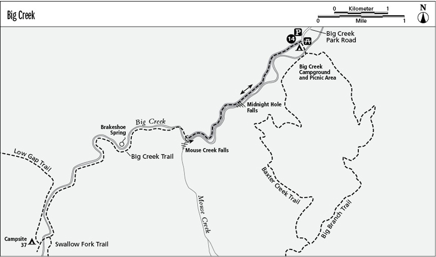
Finding the trailhead: From I-40 near the Tennessee/North Carolina state line, take exit 451 (in Tennessee) for Waterville. Turn back under the interstate to cross, then parallel, the Pigeon River past Mountain Mama’s store/eatery. About 100 yards later come to a crossroads in the village of Mount Sterling. Go straight through the intersection; the Big Creek Ranger Station is 0.2 mile ahead on the right (west). The Big Creek Picnic Area trailhead (where restrooms are available) is another 0.6 mile beyond, on the right (southwest). GPS: N35 45 06.793' / W83 06.583'
The Hike
Take off up the gated old logging railroad grade. It bumps up abruptly at first, then rises easily its entire length along Big Creek, one of the park’s most scenic streams. The grade lies on the right (north) side of Big Creek on this lower section of the trail. At 1.4 miles, Midnight Hole is a perfect, and deep, swim spot. You’ll need a hot day—the Smokies are not known for warm water. Luckily, this dipping place is at just 2,000 feet in elevation. (The park’s more forbiddingly named Icewater Spring is at almost 6,000 feet.)
Mouse Creek Falls cascades spectacularly into Big Creek from the left (south) at 2 miles (the end of the easy 4-mile round-trip day hike). At the bridge just above the falls, at 2,358 feet, there’s another pool and you cross to the left, or southeast side, of the creek.
Option
To make this a backpacking trip, continue on the Big Creek Trail beyond Mouse Creek Falls. At just less than 3 miles, Brakeshoe Spring is on the left (south), named during logging railroad days when a brakeshoe was placed under the rivulet to catch water. The creek winds more sharply above the spring, and the Swallow Fork Trail goes left (south) at 5.1 miles. The Big Creek Trail crosses the creek for the last time to the Lower Walnut Bottom backcountry campsite 37, at 5.3 miles.
Beginning backpackers would do well to consider this campsite. It’s a very scenic setting, and the hike is only a moderate 10.6-mile round-trip, with an elevation gain of 1,000 feet (also doable for more energetic day hikers). This is a popular campsite, in part because it accommodates twenty backpackers but not horse campers. A reservation is required, so book as far in advance as you can.
Miles and Directions
0.0 Start by following the old railroad grade along Big Creek.
1.4 Arrive at Midnight Hole.
2.0 Reach Mouse Creek Falls. This is the turnaround point for the 4-mile round-trip day hike.
Backpacking overnight option
2.8 Pass Brakeshoe Spring on the left (south).
5.1 Swallow Fork Trail goes left (south), stay straight to the campsite.
5.3 Arrive at campsite 37. Spend the night, then return as you came.
10.6 Arrive back at the trailhead.