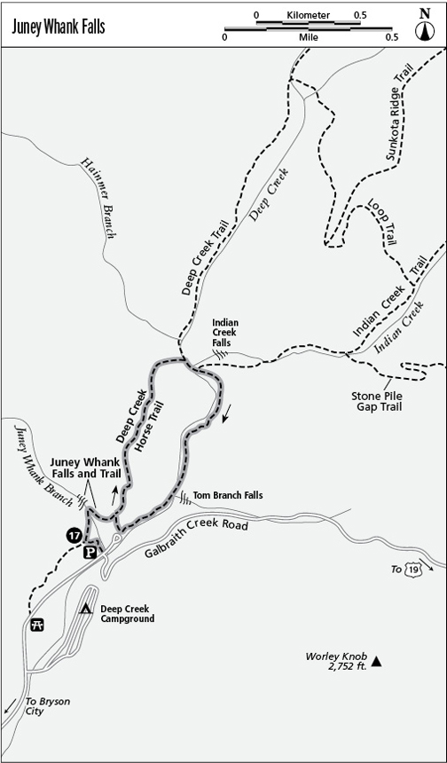
17 Juney Whank Falls

This is a nice mini-waterfall walk for kids and those with only a little time.

Distance: 0.7-mile loop

Approximate hiking time: 45 minutes

Difficulty: Easy, with a moderate climb and steeper descent

Trail surface: Mostly road grade or packed trail

Other trail users: You may see equestrians along the bridle trail portion of this hike

Best season: Best in spring or after a rain, which increases the flow in this small stream

Canine compatibility: Dogs not permitted

Fees and permits: None

Schedule: Year-round

Maps: USGS Bryson City; TOPO! North Carolina, South Carolina

Trail contacts: Information about trails, camping, road closures, as well as downloadable maps and a “Smokies Trip Planner” are available online under the “Plan Your Visit” part of the park’s excellent Web site, www.nps.gov/grsm. The Backcountry Information Office is open 9 a.m. to noon, 865-436-1297.

Special considerations: You won’t need to cope with a busy parking area if you camp at Deep Creek Campground (especially at campsites 30 and up), where it’s easy to step up onto Galbraith Creek Road. Go left (northwest) across the bridge, and you can hike both to Juney Whank Falls and on the Deep Creek Loop.

Finding the trailhead: Take any of a number of well-signed routes north from downtown Bryson City into the park. After passing the cluster of businesses at the park boundary, pass the Deep Creek Campground and the picnic area (where restrooms are avilable in season), both on the right (east), and turn left into the parking area as you reach a bridge on the right/east (the Galbraith Creek Road). The road ahead is a circular drop-off point. Take the gravel grade at the upper left (north) end of the lot. GPS: N35 27.854' / W83 26.064'

The Hike

Climb the wide road grade up and left (north) from the parking lot to a junction with the Deep Creek Horse Trail. The bridle trail descends left and rises right: Turn right (south) up the wood steps, and shortly turn right (northeast) again at the falls sign. The trail dips down nice rock steps and crosses a scenic bridge below the falls, where you’ll find an embedded bench. Just past the bridge, there’s a perfect rock seat at the base of the falls. You could almost picture a Romantic poet perched there pondering. Near the falls, this is not a trail signs are actually embedded in some bootleg paths that might mislead the inexperienced.

The trail rises beyond the falls and rejoins the bridle trail that crossed the stream above the cascade. Turn right (east) on the bridle trail junction beyond the falls. This area is very well-signed and easy to follow. Just ahead, turn right (southeast) again off the bridle trail at another sign and descend a steep, mountain laurel-sheltered gully. Don’t fear—what once was a steep ditch has been wonderfully tamed. A raised graveled tread with steps on the left isolates a rainfall course on the right, with water breaks to foil erosion. If you’re not a trail expert, this is an artful solution to an otherwise treacherously erosion-prone piece of path!

At the bottom—and more signs—turn right (southwest) on the Deep Creek Trail, and head back to the parking lot.

19474.jpg

Miles and Directions

0.0 Start on the road grade.

0.1 Reach the bridle trail junction and go up the wood steps.

0.3 Arrive at Juney Whank Falls.

0.7 Arrive back at the trailhead.