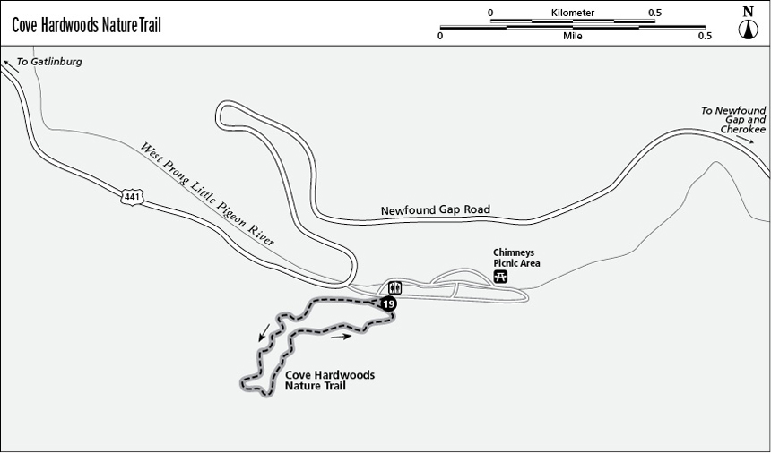
19 Cove Hardwoods Nature Trail
Here you’ll find one of the park’s best places to savor the towering grandeur of the old-growth cove hardwood forests that were so characteristic of the virgin Smokies. This must-see trail is the essential Smokies in one short, inspiring hike.
Distance: 1-mile lollipop
Approximate hiking time: 1 hour
Trail surface: Even forest path with paved steep sections
Other trail users: None; no dogs or horses allowed
Best season: April’s great for carpets of spring flowers and views to the still leafless tops of soaring trees. Summer is best for the deep shade of a cathedral grove.
Canine compatibility: Dogs not permitted
Fees and permits: None
Schedule: Closed only when inclement weather closes Newfound Gap Road
Maps: USGS Mount Le Conte; TOPO! Tennessee, Kentucky
Trail contacts: Information about trails, camping, road closures, as well as downloadable maps and a “Smokies Trip Planner” are available online under the “Plan Your Visit” part of the park’s excellent Web site, www.nps.gov/grsm. The Backcountry Information Office is open 9 a.m. to noon, 865-436-1297.
Special considerations: The self-guiding brochure for this trail is particularly worth purchasing—it’s available at the trailhead dispenser and at the park’s visitor center.
Finding the trailhead: From Newfound Gap Road turn east into the Chimneys Picnic Area, located 8.6 miles north of Newfound Gap and 4.6 miles south of the Sugarlands Visitor Center. Pull into the first parking slip on the right (south), below the trailhead sign and steps. The picnic area’s first picturesque stone restroom is to the left and just downhill. GPS: N35 38.193' / W83 29.529'
The Hike
The Chimneys Picnic Area and this nature trail serve up the “forest primeval” of stereotype. Not every unlogged forest appears “virgin” in the towering way found here. This perfect ecosystem of heavy rain and deep, rich soils permits deciduous species such as beech, yellow buckeye, red maple, basswood, yellow birch, and coniferous hemlocks to reach record proportions of grandeur in height, circumference, and age (as old as 500 years).
Up the timber-framed steps past a group picnic site, the trail splits: take a right. The trail rises to the east above the sounds of Newfound Gap Road. Near post #5 there’s a huge old hemlock felled beside the trail, with its annual rings ripe for counting. The new timber-boxed steps continue as you rise into a broad cove at 0.25 mile, then into a drainage. Swing back and forth across a stream on old-fashioned stone and concrete bridging from an earlier era. The open understory is nothing but wildflowers.
The trail leads left (southwest) of the stream, and more directly up the cove from former fields and a smaller, selectively harvested forest into unlogged old growth. After a long stretch of old concrete tread near post #9, at about 0.3 mile, the trees rise to appear much like the climax forest that so impressed the earliest Appalachian explorers—and was later almost eradicated by early twentieth-century logging companies.
At post #12, you could pinch a nerve in your neck trying to see the very tops of these trees. You’d need a family of tree huggers to express affection for this one, a yellow buckeye, one of the biggest at more than 12 feet in diameter. This is the top of the loop. If you look uphill, you can imagine the towering trees marching upward for miles—and they once did throughout the Smokies. The widely spaced trees dominate their patch of soil and reach for every ray of sunlight available. An open, uncluttered, parklike setting lies below.
The trail dips steeply from here into a drier forest, past benches, on a graveled, rocky path. The trail eventually veers right, out of the drainage, at about 0.5 mile, just above your earlier trail and back to the closing of the loop and the picnic area.
Many places in the southern Appalachians once sheltered impressive stands such as these. Today, those that remain are few and far between. This is one of the most accessible. Elsewhere in the Smokies, consider hiking the Cosby Self-Guiding Nature Trail if you’re in the northeast part of the park. If a future trip takes you to Nantahala National Forest in western North Carolina, the Joyce Kilmer Memorial Forest is another such forest trail (see FalconGuides’ Hiking North Carolina).
Miles and Directions
0.0 Start by heading up the timber-framed steps.
0.2 Travel on an old-style concrete path amid streams and wildflowers.
0.4 Reach the top of the loop amid towering trees.
1.0 Arrive back at the trailhead.