20 Chimney Tops Trail
This is one of the Smokies’ true peak experiences. Great views and exhilarating exposure are both found at the top of this rocky summit. There’s also a side trip on the Road Prong Trail that follows the remnants of the park’s oldest Native American trail and first transmountain road as it rises toward the peaks.
Distance: 4 miles out and back; plus up to 6.6 miles out-and-back Road Prong options
Approximate hiking time: 2-3 hours
Trail surface: Road-width and rocky; includes a rock scramble at the top
Other trail users: None; no dogs or horses allowed
Best season: Spring, when the peak stands above lower lime-green mountainsides; and late fall. Winter can create tricky footing on the rocky summit.
Canine compatibility: Dogs not permitted
Fees and permits: None
Schedule: Closed only when inclement weather closes Newfound Gap Road.
Maps: USGS Mount Le Conte; TOPO! Tennessee, Kentucky
Trail contacts: Information about trails, camping, road closures, as well as downloadable maps and a “Smokies Trip Planner” are available online under the “Plan Your Visit” part of the park’s excellent Web site, www.nps.gov/grsm. The Backcountry Information Office is open 9 a.m. to noon, 865-436-1297.
Special considerations: This is one of only a few hikes in this book that is not easy, but was selected because it’s one of the shortest, high-adventure hikes. Do not undertake this trail lightly, but it is often hiked by well-equipped, motivated novices in good shape. That, of course, makes this a very popular path. Go early, during the week, and in the off-season if passing lanes on trails aren’t your style.
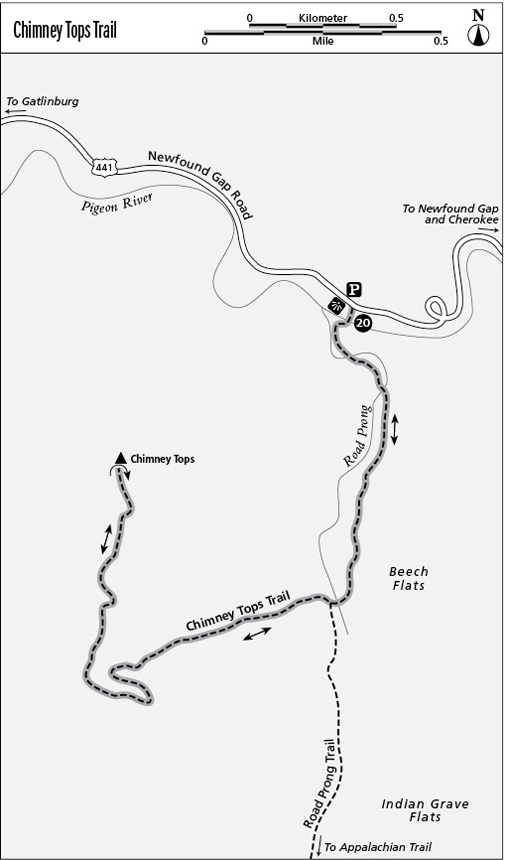
Finding the trailhead: The Chimney Tops parking area is on Newfound Gap Road, 7.1 miles south of the Sugarlands Visitor Center, 2.5 miles south of the Chimneys Picnic Area (closest available restrooms), and 22 miles north of the Oconaluftee Visitor Center. GPS: N35 38.146' / W83 28.195'
The Hike
This popular trail launches a wide and graded trail down to a bridge over Walker Camp Prong. It’s uphill from there, and not far beyond you’ll cross another bridge, this time over Road Prong. Together, these streams scour the valley below as the West Prong of the Little Pigeon River.
The trail ascends along gushing Road Prong. After the third bridge on that stream, head right (west) at the junction, where the Road Prong Trail continues left (south) up the watershed (described in the Option below). Not far above the turn, the trail stands steeply up, with no switchbacks, confined in a tight ramp toward the ridge crest of Sugarland Mountain. As the trail veers right (north), the grade becomes more gradual, then dips to the apex of the ridge that leads to where the Chimneys rise into the sky.
The last climb is a rocky, low-grade scramble up the crags. Rock jocks may be comfortable with the first route straight up the pinnacle, but a warning sign urges the less adventurous (less foolhardy?) around the right side for an easier but still exciting climb to the rocky summit.
Savor the vista—among the best in the Smokies. To start, this is a summit perch as iconic as you’re likely to find anywhere—and you’ve earned it! To the northwest, the Sugarlands Valley plummets to Gatlinburg. Northeast, the squiggle of The Loop in the Newfound Gap Road lies below. Far above, Mount LeConte shows off all four of its named summits.
The horizon begs to be scanned. Consider taking a topo map of the park and a compass on this hike. Correctly orient the open map by turning it until north on the compass and on the compass rose of the map match. Then aim the compass at landmarks on the horizon—but keep the dial aligned with north on the map—and when you place the compass down on Chimney Tops, it should be pointing to the spot on the horizon you’re trying to identify. The Smokies is a wealth of opportunities for this kind of fun (for more, check out FalconGuides’ Route Finding).
Option
If you’d like to see a lofty, more defined section of the old road across the Smokies like the Sugarlands Valley Self-Guiding Nature Trail, follow the Chimney Tops Trail for 0.9 mile, and where that trail turns right (west), follow the Road Prong Trail left (south) as far as you care to walk. This historic old Native American trail, said to be the oldest in the park, has seen centuries of travel on its rise to and across Indian Gap.
The trail was upgraded to road status in the 1830s and was the only road over the Smokies until the 1920s, when the Newfound Gap Road was built. Indian Gap was once thought to be the Smokies’ lowest gap, until Professor Arnold Guyot determined that to be Newfound Gap, hence the change in the road crossing. The road saw a lot of activity in the Civil War, including improvements by a force made up of many Cherokee Indians and led by Colonel William H. Thomas, a white man raised as a Cherokee who would later become the tribe’s chief.
Just 0.3 mile above the divergence of the Chimney Tops and Road Prong Trails, you’ll reach Indian Grave Flats, the burial site of a Cherokee guide killed by Union raiders. Just 0.1 mile above that, there’s a tricky stream crossing at Standing Rock Ford (you won’t miss the standing rock). About 0.5 mile above is Talking Falls.
The trail becomes rougher as it reaches the crest of the ridge and dips over to the Clingmans Dome Road, 2.4 miles from the turnoff to Chimney Tops. For those who want to wander one way down the trail, you can spot a car or arrange a shuttle between the Chimney Tops Trail parking area and the Road Prong Trail at the Indian Gap Parking Area, located 1.2 miles from Newfound Gap on Clingmans Dome Road.
Miles and Directions
0.0 Start from the parking area.
0.1 Cross the first bridge over Walker Camp Prong.
0.4 Cross the second bridge over Road Prong.
0.8 Cross the third bridge over Road Prong.
0.9 At the Road Prong Trail junction, stay right (west) on the Chimney Tops Trail.
2.0 Reach the Chimney Tops summit. This is the turnaround point.
4.0 Arrive back at the trailhead.