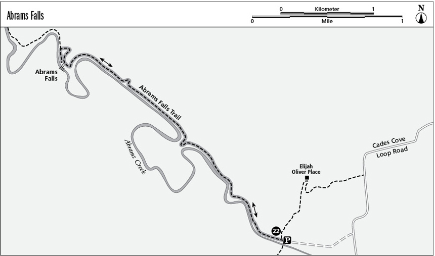
22 Abrams Falls
This dramatic waterfall—the park’s biggest by volume of water—leaps off a ledge into a misty plunge pool. Tackle this trail after significant rain and you’ll be impressed.
Distance: 5 miles out and back
Approximate hiking time: 3 to 4 hours
Trail surface: Packed earth, but with some rocky, stony sections
Other trail users: None; no dogs or horses allowed
Best season: Spring, after rainfall, and during off-times (such as weekdays) to escape the crowds
Canine compatibility: Dogs not permitted
Fees and permits: None
Schedule: Cades Cove Loop Road is open sunrise to sunset, 7 days a week, year–round. Between early May and late September, it is closed Wednesday and Sunday mornings till 10 a.m. for use by pedestrians and bicyclists.
Maps: USGS Calderwood and Cades Cove; TOPO! Tennessee, Kentucky
Trail contacts: Information about trails, camping, road closures, as well as downloadable maps and a “Smokies Trip Planner” are available online under the “Plan Your Visit” part of the park’s excellent Web site, www.nps.gov/grsm. The Backcountry Information Office is open 9 a.m. to noon, 865-436-1297.
Special considerations: The 11-mile loop of Cades Cove—one of the park’s best motor tours—is justifiably popular for its outstanding scenery (a pristine rural valley surrounded by summits) and great interpretation of early Smokies’ residents. Pick up the Cades Cove Tour booklet from the roadside information kiosk at the start of the loop. At all but off-times and seasons, or in inclement weather, this can be a slow crawl of motorists stopping to ogle deer and bears, etc. Do everyone a favor—do not stop in the road for any reason. If you want to look, at least pull off or out of the way so the traffic flow will not be impeded.
Other: If this hike is too much for you, start at the Abrams Falls trailhead, but turn right (north), across the bridge, and make an easy 1-mile out-and-back hike to the Elijah Oliver Place. Notice the “stranger room” added onto the front porch, a feature you’ll also see at the Dan Lawson Place farther along the loop. Or consider the new Pine Oak Nature Trail in the Cades Cove Campground, a tree identification trail reopened with the recent decision to no longer maintain the Cades Cove Self-Guiding Nature Trail (located on the loop road 0.4 past the Cable Mill Historic Area and visitor center on the right/west).
Finding the trailhead: From the US 321/TN 73 intersection in Townsend, drive 2.3 miles into the park and go right (southwest) onto the Laurel Creek Road at the junction where TN 73 continues left (east) as the Little River Road to (and from) Sugarlands Visitor Center. Measuring from this junction, the campground/picnic area (where restrooms are available at the nearby camp store) and the start of the Cades Cove motor loop is at 7.5 miles. At 5.1 miles from the campground, turn right (west) onto the 0.5-mile access road to the trailhead. GPS: N35 35.467' / W83 51.032'
The Hike
Cross the bridge to start the hike, and the trail wanders streamside on a rocky, stony tread. It then climbs moderately to a crest, and dips into a beautiful dark forest of bigger trees. Now on a packed earth path, you’ll dip back down to the stream—the first of three times the route will climb into the quiet well above the rushing sounds of Abrams Creek, and then return.
You’ll wander along the level streamside for a significant distance after the first hump, crossing a single-log bridge, with trailside views of the creek. Then you’ll rise again, more steeply now, on a packed tread into a drier pine forest past significant signs of a forest fire (a controlled burn conducted around 2006). At the top the trail slips through the craggy crest of Arbutus Ridge on a shelf hewn from the rock.
Past the ridge the trail jogs into a really beautiful spot—a sharply benched trail along a rock outcropping with many kinds of wildflowers. Heading down again, the route returns to parallel the stream. Travel a second long flat stretch, where the creek suddenly dances to life over beautiful ledges. A second log bridge crosses a rocky sluice and you pass through towering, evenly spaced trees in an open forest (more evidence of fire—this one part of a backfire set to combat a blaze started by lightning). Then you’ll climb again, as does the river, but you are above it as it weaves in and around ridges into drier woods with more evidence of fire.
At a sign warning against climbing near the falls (and urging parents to carefully control children), Abrams Falls is immediately below but not visible. The trail turns right (north), descends to cross another bridge over a side stream, then follows that stream left (west) to a junction on the bank of Abrams Creek. Abrams Falls Trail continues to the right (north) along the stream, but go left (south), back across the side stream on another bridge to the base of the falls.
The sign at the streamside junction (and another back at the trailhead) warns that a handful of people have drowned in the swirling currents at the base of this thundering cataract (a word to the wise!). A ledge provides safe access along the base of the cliff to the edge of the cascade (but use caution—don’t get too close). The Cherokee name for Cades Cove, Tsiyahi, means place of the otter. Keep your eyes peeled—you might be lucky and glimpse a river otter. More than 300 were released in the Smokies in 1984 and they often cavort in the pool.
Miles and Directions
0.0 Start from the parking area at the end of the gravel access road.
0.1 Go left across the bridge.
1.0 Cross Arbutus Ridge.
2.1 Pass the waterfall warning sign at the crest of the ridge.
2.4 Go left (south) at the streamside junction and the second warning sign about drownings.
2.5 Reach the base of the falls.
5.0 Arrive back at the trailhead.