Trails, Roads, and Landmarks
After the Jolly Boys had been hunting in the area for about five years, they became familiar with the terrain and knew where they should position themselves to see and kill deer.
I have read numerous books on deer hunting and found that almost every camp has names for the various deer stands, walking trails, and logging roads that run through their hunting area. The Jolly Boys were no different, and they quickly named their deer stands and other landmarks so that when a day’s hunt had concluded, each hunter could tell his story of where he had been that day and what he had seen. As I began to become familiar with the general area in which we hunted, I started to make maps when I was about sixteen years old. I transferred that information onto a large window shade along with a separate window shade showing the history of when deer had been shot, the area where each deer was killed, and the name of the successful hunter. I was able to use the shack log to compile this information for the years before I was allowed to hunt up at Blue Heaven.
The area around the shack had a network of logging roads used by loggers back in the 1940s when they were harvesting basswood from the area. The main road into our camp ran from Highway 27 east, past our hunting camp all the way to Nelson Lake, about two miles away. They named this road Birch Street, as it passed by Merle’s deer stand, which he called the Birch. Birch Street from Highway 27 to our hunting camp was always a mess, because it wound through many low-lying areas with swampland on either side of the road and lots of mud holes. However, after Birch Street passed our camp, the road went into the hardwood hills and became a very decent road with only a few bad spots.
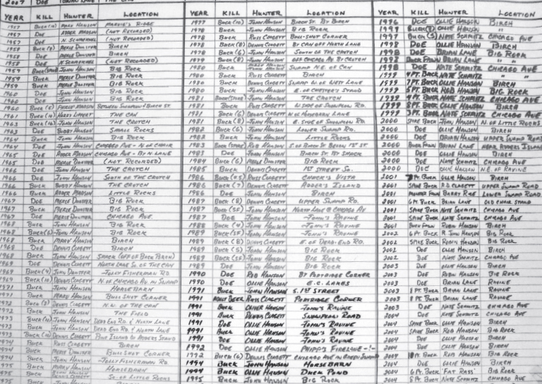
The official record of deer harvested by hunters from Blue Heaven
The Birch was in the hardwood hills area, and Merle had built himself a platform among three yellow birch trees that overlooked a vast number of hardwoods, with a tag alder swamp about a hundred yards to the south of his stand. Deer would stick close to the tag alder swamp to escape any danger they might encounter, making this area a hot spot for deer moving through the area. Many deer have been shot from the Birch over the years, and, although the three birch trees are no longer there, the deer stand is still coveted by the hunters from our deer camp.
Just below the Birch and next to the tag alder swamp was a logging road named Snow Plow Road, which also ran east and west, parallel to Birch Street. When the Jolly Boys first started hunting in the area, they found a V-shaped wooden snowplow by the side of the road that had been abandoned by loggers. The old snowplow rotted away long ago, but we still refer to the road as Snow Plow Road.
The Jolly Boys named the other main road in the area Chicago Avenue. This road ran east and west several hundred yards north of Birch Street, terminating at the beginning of a large swamp. Chicago Avenue has several hot deer stands on or near this old logging road. Adder built a platform among three basswood trees, put a chair on it, and nicknamed it the Chair. His stand overlooked a cedar swamp running through a small ravine down to a tag alder swamp. Many deer were taken from or near this great stand, also, which is now only a memory, the platform and Adder’s chair having long ago become victims of the elements.
About one hundred yards east of the Chair just off of Chicago Avenue is an area that is called the Ravine, which sits high on a hardwood hill overlooking a tag alder swamp to the north. A cedar swamp next to Chicago Avenue allows for natural deer movement between these two areas. Another hundred yards brings one to a stand called the Crotch, named after a large basswood with a huge crotch in the lower part of its trunk. In this crotch, a hunter could sit to view the surrounding hardwoods and a small creek, which was a natural draw for deer passing through the area.
About fifty yards east of the Crotch is a stand we call the End of Chicago Avenue, which terminates near a tag alder swamp. In recent years, this area has yielded numerous deer for the hunter who has the patience to sit in the early morning hours or at dusk, when the deer are moving.
Branching off Chicago Avenue and running north is a road that has been named North Lane. This road is almost overgrown and has diminished to a faint trail, but it runs through a stand of very thick tag alders and hardwoods that could definitely be considered big buck country.
At a point just before North Lane turns to the east, the Jolly Boys found a five-gallon gas can that loggers left hanging on a tree. They named this stand the Can. Some of the bigger bucks killed in recent years have been shot from tree stands in this area, which is a blend of tag alders, aspens, and pine trees.
Running east from the shack is a road we call Little Rock Road. It winds up a huge hill containing two sizable rocks, which have been inappropriately named the Little Rocks. The view from this stand is amazing. If you continue east on Little Rock Road, you will go through an evergreen swamp and find another large rock called the Big Rock. The Big Rock is actually smaller than the Little Rocks, but nobody has bothered to change the names of these landmarks over the past fifty years. Until recently, due to nearby logging operations, the Big Rock was probably the most successful deer stand in our area.
South of the Big Rock is a stand that we named the Horse Barn after an abandoned one-horse barn used by the loggers years ago. After many decades, the elements have finally rotted the old barn into the leaves. On the west side of the shack, the Upper Swamp Road runs north and terminates in a cedar swamp. It is an excellent hunting area. On the south side of the shack, the Lower Swamp Road goes south down to the Jolly Fisherman Road, which is a main roadway to cabins on Nelson Lake. Logging in recent years has left the area with thick underbrush, and it’s very difficult to hunt, due to limited visibility.
If all of these names, terrains, and descriptions leave you befuddled, that’s okay. It usually takes several deer seasons hunting these woods before one sees the big picture, but knowing the names of the roads and landmarks is essential in order to relate to everyone else in camp where you have been or where you plan to go during the hunt.