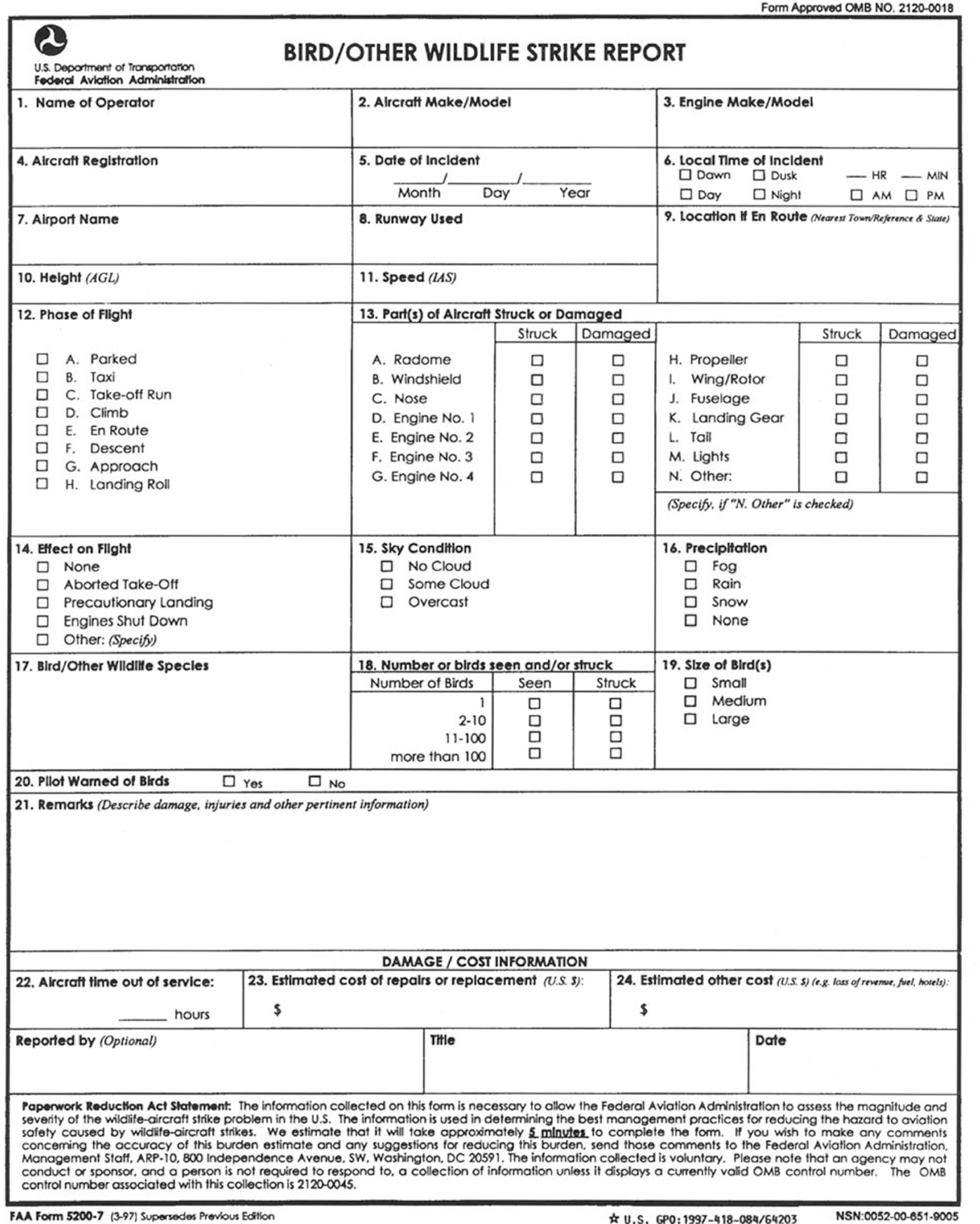
Appendix 1. Bird/Other Wildlife Strike Report

Fold and Tape Here
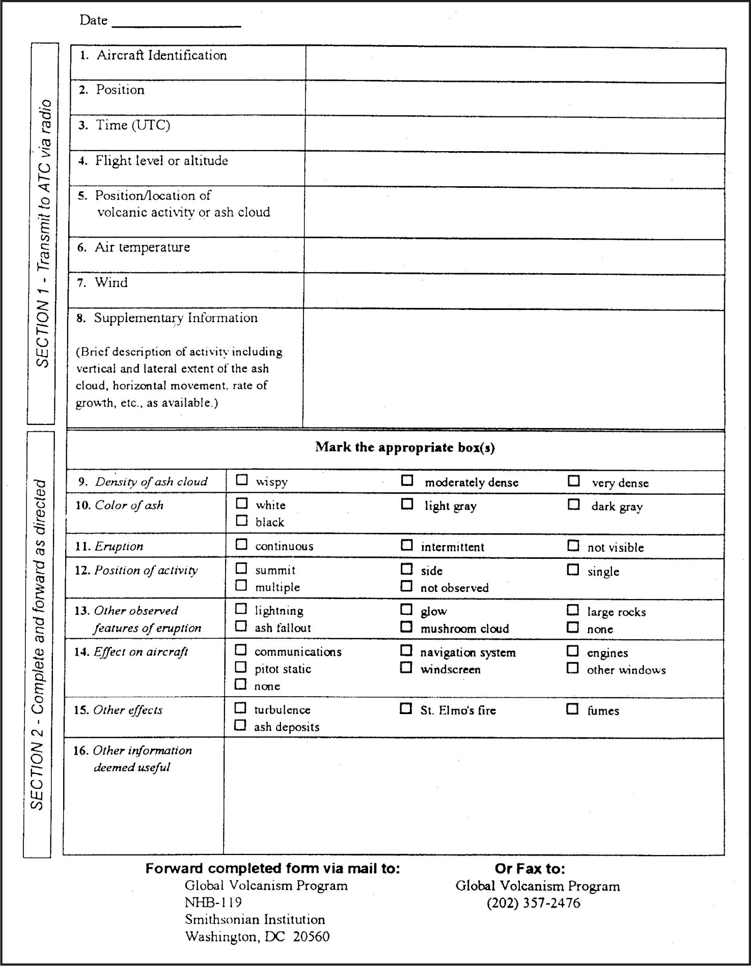
Appendix 2. Volcanic Activity Reporting Form (VAR)
Appendix 3. Abbreviations/Acronyms
As used in this manual, the following abbreviations/acronyms have the meanings indicated.
Abbreviation/ Acronym |
Meaning |
AAWU..... |
Alaskan Aviation Weather Unit |
AAS ....... |
Airport Advisory Service |
AC ........ |
Advisory Circular |
ACAR ..... |
Aircraft Communications Addressing and Reporting System |
ADCUS .... |
Advise Customs |
ADDS...... |
Aviation Digital Data Service |
ADF....... |
Automatic Direction Finder |
ADIZ ...... |
Air Defense Identification Zone |
ADS-B ..... |
Automatic Dependent Surveillance-Broadcast |
AFB ....... |
Air Force Base |
AFCS ...... |
Automatic Flight Control System |
AFIS....... |
Automatic Flight Information Service |
AFM....... |
Aircraft Flight Manual |
AGL....... |
Above Ground Level |
AHRS...... |
Attitude Heading Reference System |
AIM ....... |
Aeronautical Information Manual |
AIRMET ... |
Airmen’s Meteorological Information |
AIS........ |
Aeronautical Information Services |
ALD....... |
Available Landing Distance |
ALDARS .. . |
Automated Lightning Detection and Reporting System |
ALS ....... |
Approach Light Systems |
AMSL ..... |
Above Mean Sea Level |
ANP....... |
Actual Navigation Performance |
AOCC ..... |
Airline Operations Control Center |
AP ........ |
Autopilot System |
APV....... |
Approach with Vertical Guidance |
AR ........ |
Authorization Required |
ARENA .... |
Areas Noted for Attention |
ARFF IC .... |
Aircraft Rescue and Fire Fighting Incident Commander |
ARINC..... |
Aeronautical Radio Incorporated |
ARO....... |
Airport Reservations Office |
ARSA...... |
Airport Radar Service Area |
ARSR...... |
Air Route Surveillance Radar |
ARTCC..... |
Air Route Traffic Control Center |
ARTS ...... |
Automated Radar Terminal System |
ASDE-X .. . |
Airport Surface Detection Equipment -Model X |
ASOS...... |
Automated Surface Observing System |
ASR....... |
Airport Surveillance Radar |
ASRS...... |
Aviation Safety Reporting System |
ASSC |
Airport Surface Surveillance Capability |
ATC ....... |
Air Traffic Control |
ATCRBS .... |
Air Traffic Control Radar Beacon System |
ATCSCC .... |
Air Traffic Control System Command Center |
ATCT...... |
Airport Traffic Control Tower |
ATD ....... |
Along-Track Distance |
ATIS....... |
Automatic Terminal Information Service |
ATT ....... |
Attitude Retention System |
AWC....... |
Aviation Weather Center |
AWOS ..... |
Automated Weather Observing System |
AWTT ..... |
Aviation Weather Technology Transfer |
AWW...... |
Severe Weather Forecast Alert |
BAASS ..... |
Bigelow Aerospace Advanced Space Studies |
BBS ....... |
Bulletin Board System |
BC ........ |
Back Course |
BECMG .... |
Becoming group |
C/A........ |
Coarse Acquisition |
CARTS ..... |
Common Automated Radar Terminal System (ARTS) (to include ARTS IIIE and ARTS IIE) |
CAT ....... |
Clear Air Turbulence |
CD ........ |
Controller Display |
CDI........ |
Course Deviation Indicator |
CDR....... |
Coded Departure Route |
CERAP..... |
Combined Center/RAPCON |
CFA ....... |
Controlled Firing Area |
CFIT....... |
Controlled Flight into Terrain |
CFR ....... |
Code of Federal Regulations |
COA....... |
Certificate of Waiver or Authorization |
CPDLC ..... |
Controller Pilot Data Link Communications |
CTAF...... |
Common Traffic Advisory Frequency |
CVFP...... |
Charted Visual Flight Procedure |
CVRS...... |
Computerized Voice Reservation System |
CWA....... |
Center Weather Advisory |
CWSU ..... |
Center Weather Service Unit |
DA ........ |
Decision Altitude |
DCA....... |
Ronald Reagan Washington National Airport |
DCP ....... |
Data Collection Package |
DER....... |
Departure End of Runway |
DH ........ |
Decision Height |
DME....... |
Distance Measuring Equipment |
DME/N..... |
Standard DME |
DME/P..... |
Precision DME |
DOD....... |
Department of Defense |
DP ........ |
Instrument Departure Procedure |
DPU....... |
Data Processor Unit |
DRT ....... |
Diversion Recovery Tool |
DRVSM .... |
Domestic Reduced Vertical Separation Minimum |
DVA....... |
Diverse Vector Area |
DVFR...... |
Defense Visual Flight Rules |
DVRSN .... |
Diversion |
EDCT...... |
Expect Departure Clearance Time |
EFAS ...... |
En Route Flight Advisory Service |
EFV ....... |
Enhanced Flight Visibility |
EFVS ...... |
Enhanced Flight Vision System |
ELT........ |
Emergency Locator Transmitter |
EMAS ..... |
Engineered Materials Arresting System |
EPE ....... |
Estimate of Position Error |
ESV ....... |
Expanded Service Volume |
ETA ....... |
Estimated Time of Arrival |
ETD ....... |
Estimated Time of Departure |
ETE ....... |
Estimated Time En Route |
EWINS..... |
Enhanced Weather Information System |
EWR....... |
Newark International Airport |
FA......... |
Area Forecast |
FAA ....... |
Federal Aviation Administration |
FAF........ |
Final Approach Fix |
FAROS..... |
Final Approach Runway Occupancy Signal |
FAWP...... |
Final Approach Waypoint |
FB......... |
Fly-by |
FCC ....... |
Federal Communications Commission |
FD ........ |
Flight Director System |
FDC ....... |
Flight Data Center |
FDE ....... |
Fault Detection and Exclusion |
FIR........ |
Flight Information Region |
FIS ........ |
Flight Information Service |
FISDL ..... |
Flight Information Services Data Link |
FLIP....... |
Flight Information Publication |
FMS ....... |
Flight Management System |
FO ........ |
Fly-over |
FPA........ |
Flight Path Angle |
FPV ....... |
Flight Path Vector |
FPNM...... |
Feet Per Nautical Mile |
FSDO...... |
Flight Standards District Office |
FSS........ |
Flight Service Station |
GBAS...... |
Ground Based Augmentation System |
GEO....... |
Geostationary Satellite |
GLS ....... |
GBAS Landing System |
GNSS...... |
Global Navigation Satellite System |
GNSSP..... |
Global Navigation Satellite System Panel |
GPS ....... |
Global Positioning System |
GRI........ |
Group Repetition Interval |
GSD....... |
Geographical Situation Display |
GUS....... |
Ground Uplink Station |
HAT ....... |
Height Above Touchdown |
HDTA...... |
High Density Traffic Airports |
HEMS ..... |
Helicopter Emergency Medical Services |
HIRL ...... |
High Intensity Runway Lights |
HRR....... |
Helicopter Rapid Refueling Procedures |
HUD....... |
Head-Up Display |
Hz......... |
Hertz |
IAF........ |
Initial Approach Fix |
IAP........ |
Instrument Approach Procedure |
IAS........ |
Indicated Air Speed |
IAWP...... |
Initial Approach Waypoint |
ICAO...... |
International Civil Aviation Organization |
IF ......... |
Intermediate Fix |
IFR........ |
Instrument Flight Rules |
ILS ........ |
Instrument Landing System |
ILS/PRM .. . |
Instrument Landing System/Precision Runway Monitor |
IM......... |
Inner Marker |
IMC ....... |
Instrument Meteorological Conditions |
InFO....... |
Information For Operators |
INS........ |
Inertial Navigation System |
IOC........ |
Initial Operational Capability |
IR......... |
IFR Military Training Route |
IRU........ |
Inertial Reference Unit |
ITWS ...... |
Integrated Terminal Weather System |
JFK........ |
John F. Kennedy International Airport |
kHz........ |
Kilohertz |
LAA....... |
Local Airport Advisory |
LAAS...... |
Local Area Augmentation System |
LAHSO .... |
Land and Hold Short Operations |
LAWRS .... |
Limited Aviation Weather Reporting Station |
LDA....... |
Localizer Type Directional Aid |
LDA/PRM .. |
Localizer Type Directional Aid/Precision Runway Monitor |
LGA....... |
LaGuardia Airport |
LIRL....... |
Low Intensity Runway Lights |
LLWAS..... |
Low Level Wind Shear Alert System |
LLWAS NE . |
Low Level Wind Shear Alert System Network Expansion |
LLWAS-RS . |
Low Level Wind Shear Alert System Relocation/Sustainment |
LNAV...... |
Lateral Navigation |
LOC....... |
Localizer |
LOP ....... |
Line—of—position |
LORAN .... |
Long Range Navigation System |
LP......... |
Localizer Performance |
LPV ....... |
Localizer Performance with Vertical Guidance |
LUAW ..... |
Line Up and Wait |
LZ......... |
Landing Zone |
MAHWP .. . |
Missed Approach Holding Waypoint |
MAP....... |
Missed Approach Point |
MAWP..... |
Missed Approach Waypoint |
MDA ...... |
Minimum Descent Altitude |
MEA....... |
Minimum En Route Altitude |
MEARTS ... |
Micro En Route Automated Radar Tracking System |
METAR .... |
Aviation Routine Weather Report |
MHz....... |
Megahertz |
MIRL...... |
Medium Intensity Runway Lights |
MM ....... |
Middle Marker |
MOA ...... |
Military Operations Area |
MOCA..... |
Minimum Obstruction Clearance Altitude |
MRA ...... |
Minimum Reception Altitude |
MRB....... |
Magnetic Reference Bearing |
MSA....... |
Minimum Safe Altitude |
MSAW..... |
Minimum Safe Altitude Warning |
MSL....... |
Mean Sea Level |
MTI ....... |
Moving Target Indicator |
MTOS...... |
Mountain Obscuration |
MTR....... |
Military Training Route |
MVA....... |
Minimum Vectoring Altitude |
MWA ...... |
Mountain Wave Activity |
MWO...... |
Meteorological Watch Office |
NAS....... |
National Airspace System |
NASA...... |
National Aeronautics and Space Administration |
NAVAID .... |
Navigational Aid |
NAVCEN .. . |
Coast Guard Navigation Center |
NCWF ..... |
National Convective Weather Forecast |
NDB....... |
Nondirectional Radio Beacon |
NEXRAD .. . |
Next Generation Weather Radar |
NFDC...... |
National Flight Data Center |
NGA....... |
National Geospatial-Intelligence Agency |
NM........ |
Nautical Mile |
NMAC..... |
Near Midair Collision |
NOAA |
National Oceanic and Atmospheric Administration |
NOPAC .... |
North Pacific |
NoPT ...... |
No Procedure Turn Required |
NPA ....... |
Nonprecision Approach |
NRS ....... |
Navigation Reference System |
NSA ....... |
National Security Area |
NSW....... |
No Significant Weather |
NTSB...... |
National Transportation Safety Board |
NTZ ....... |
No Transgression Zone |
NWS....... |
National Weather Service |
OAT ....... |
Outside Air Temperature |
OBS ....... |
Omni-bearing Selector |
ODP....... |
Obstacle Departure Procedure |
OIS........ |
Operational Information System |
OIS........ |
Obstacle Identification Surface |
OM........ |
Outer Marker |
ORD....... |
Chicago O’Hare International Airport |
PA......... |
Precision Approach |
PAPI....... |
Precision Approach Path Indicator |
PAR ....... |
Precision Approach Radar |
PAR ....... |
Preferred Arrival Route |
PC......... |
Personal Computer |
P/CG....... |
Pilot/Controller Glossary |
PDC ....... |
Pre-departure Clearance |
PFD ....... |
Personal Flotation Device |
PinS ....... |
Point-in-Space |
PIREP...... |
Pilot Weather Report |
POB ....... |
Persons on Board |
POFZ ...... |
Precision Obstacle Free Zone |
POI........ |
Principal Operations Inspector |
PPS........ |
Precise Positioning Service |
PRM....... |
Precision Runway Monitor |
PT......... |
Procedure Turn |
QICP ...... |
Qualified Internet Communications Provider |
RA ........ |
Resolution Advisory |
RAA....... |
Remote Advisory Airport |
RAIM...... |
Receiver Autonomous Integrity Monitoring |
RAIS ...... |
Remote Airport Information Service |
RBDT...... |
Ribbon Display Terminals |
RCAG ..... |
Remote Center Air/Ground |
RCC....... |
Rescue Coordination Center |
RCLS...... |
Runway Centerline Lighting System |
RCO....... |
Remote Communications Outlet |
RD ........ |
Rotor Diameter |
REIL....... |
Runway End Identifier Lights |
REL....... |
Runway Entrance Lights |
RFM....... |
Rotorcraft Flight Manual |
RIL........ |
Runway Intersection Lights |
RLIM...... |
Runway Light Intensity Monitor |
RMI ....... |
Radio Magnetic Indicator |
RNAV...... |
Area Navigation |
RNP....... |
Required Navigation Performance |
ROC....... |
Required Obstacle Clearance |
RPAT |
RNP Parallel Approach Runway Transitions |
RVR....... |
Runway Visual Range |
RVSM...... |
Reduced Vertical Separation Minimum |
RWSL...... |
Runway Status Light |
SAFO...... |
Safety Alerts For Operators |
SAM....... |
System Area Monitor |
SAR....... |
Search and Rescue |
SAS ....... |
Stability Augmentation System |
SATR...... |
Special Air Traffic Rules |
SBAS...... |
Satellite-based Augmentation System |
SCAT-1 DGPS...... |
Special Category I Differential GPS |
SDF ....... |
Simplified Directional Facility |
SFL........ |
Sequenced Flashing Lights |
SFR ....... |
Special Flight Rules |
SFRA...... |
Special Flight Rules Area |
SIAP....... |
Standard Instrument Approach Procedure |
SID........ |
Standard Instrument Departure |
SIGMET .... |
Significant Meteorological Information |
SM ........ |
Statute Mile |
SMGCS .... |
Surface Movement Guidance Control System |
SNR....... |
Signal-to-noise Ratio |
SOIA |
Simultaneous Offset Instrument Approaches |
SOP ....... |
Standard Operating Procedure |
SPC ....... |
Storm Prediction Center |
SPS........ |
Standard Positioning Service |
STAR...... |
Standard Terminal Arrival |
STARS |
Standard Terminal Automation Replacement System |
STMP...... |
Special Traffic Management Program |
TA......... |
Traffic Advisory |
TAA....... |
Terminal Arrival Area |
TAC ....... |
Terminal Area Chart |
TACAN .... |
Tactical Air Navigation |
TAF ....... |
Aerodrome Forecast |
TAS ....... |
True Air Speed |
TCAS ...... |
Traffic Alert and Collision Avoidance System |
TCH ....... |
Threshold Crossing Height |
TD ........ |
Time Difference |
TDLS...... |
Tower Data Link System |
TDWR..... |
Terminal Doppler Weather Radar |
TDZ....... |
Touchdown Zone |
TDZE...... |
Touchdown Zone Elevation |
TDZL...... |
Touchdown Zone Lights |
TEC ....... |
Tower En Route Control |
THL....... |
Takeoff Hold Lights |
TIBS....... |
Telephone Information Briefing Service |
TIS ........ |
Traffic Information Service |
TIS-B ...... |
Traffic Information Service-Broadcast |
TLS ....... |
Transponder Landing System |
TPP........ |
Terminal Procedures Publications |
TRSA...... |
Terminal Radar Service Area |
TSO ....... |
Technical Standard Order |
TWEB ..... |
Transcribed Weather Broadcast |
TWIB ...... |
Terminal Weather Information for Pilots System |
UA ........ |
Unmanned Aircraft |
UAS....... |
Unmanned Aircraft System |
UAV....... |
Unmanned Aerial Vehicle |
UFO....... |
Unidentified Flying Object |
UHF....... |
Ultrahigh Frequency |
U.S........ |
United States |
USCG...... |
United States Coast Guard |
UTC....... |
Coordinated Universal Time |
UWS....... |
Urgent Weather SIGMET |
VAR....... |
Volcanic Activity Reporting |
VASI....... |
Visual Approach Slope Indicator |
VCOA ..... |
Visual Climb Over the Airport |
VDA....... |
Vertical Descent Angle |
VDP....... |
Visual Descent Point |
VFR....... |
Visual Flight Rules |
VGSI ...... |
Visual Glide Slope Indicator |
VHF....... |
Very High Frequency |
VIP........ |
Video Integrator Processor |
VMC ...... |
Visual Meteorological Conditions |
VMINI ...... |
Instrument flight minimum speed, utilized in complying with minimum limit speed requirements for instrument flight |
VNAV ...... |
Vertical Navigation |
VNE ...... |
Never exceed speed |
VNEI ....... |
Instrument flight never exceed speed, utilized instead of VNE for compliance with maximum limit speed requirements for instrument flight |
VOR....... |
Very High Frequency Omni-directional Range |
VORTAC ... |
VHF Omni-directional Range/Tactical Air Navigation |
VOT....... |
VOR Test Facility |
VR ........ |
VFR Military Training Route |
VREF ....... |
The reference landing approach speed, usually about 1.3 times Vso plus 50 percent of the wind gust speed in excess of the mean wind speed. |
VSO........ |
The stalling speed or the minimum steady flight speed in the landing configuration at maximum weight. |
VTF ....... |
Vector to Final |
VV ........ |
Vertical Visibility |
VVI ....... |
Vertical Velocity Indicator |
VY ........ |
Speed for best rate of climb |
VYI........ |
Instrument climb speed, utilized instead of VY for compliance with the climb requirements for instrument flight |
WA........ |
AIRMET |
WAAS ..... |
Wide Area Augmentation System |
WFO ....... |
Weather Forecast Office |
WGS-84 .... |
World Geodetic System of 1984 |
WMO ...... |
World Meteorological Organization |
WMS .. |
Wide-Area Master Station |
WMSC ..... |
Weather Message Switching Center |
WMSCR .... |
Weather Message Switching Center Replacement |
WP ........ |
Waypoint |
WRA ...... |
Weather Reconnaissance Area |
WRS ....... |
Wide-Area Ground Reference Station |
WS ........ |
SIGMET |
WSO ...... |
Weather Service Office |
WSP ....... |
Weather System Processor |
WST ....... |
Convective Significant Meteorological Information |
WW ....... |
Severe Weather Watch Bulletin |