Epilogue
Today, the entity “Niagara National Historic Sites” represents a complex of designated National Historic Sites in and near Niagara-on-the-Lake: Fort George, Fort Mississauga, Navy Hall, Butler’s Barracks, Queenston Heights, Mississauga Point Lighthouse, Navy Island, and the Battlefield of Fort George. The estimated 285 acres that remain of the original Fort George Military Reserve and now known as the Commons are not designated. Requests to the Historic Sites and Monuments Board of Canada in 1986[1] and to the federal government again in 1991[2] for designation of the Commons were turned down. However, contained in the Commemorative Integrity Statement (CIS) formulated for each designated site in 1998 there is reference to the “historic place” of that site. In the case of Fort George its historic place is:
the extensive cleared area extending to the Niagara River and across the Commons, which provided clear fields of fire; and the viewplanes to the river, Butler’s Barracks and the town.[3]
Similarly, in the CIS for Butler’s Barracks:
the historic place is therefore not only the immediate area of the five buildings, but includes the entire area enclosed by the palisades, the locations of the buildings and facilities outside the palisade (commandant’s quarters, etc.) and that part of the Commons occupied by Camp Niagara. Effectively, the entire area of the Commons is included.[4]
In essence, since the historic place is considered the extent of the designated site, the present Commons is included in the designations of both Fort George and Butler’s Barracks. Moreover, the Management Plan for the Niagara National Historic Sites, accepted in 2007 and up for review in 2012, clearly states as a “Key Action” that “Parks Canada will not consider additional encroachments on the Commons.” This would seem to indicate that the Commons today is protected from both major intrusions as well as minor encroachments along the edges. However, further encroachment requests will be decided by the Minister of the Environment, who hopefully would listen to local concerns.
Today all the Niagara National Historic Sites are administered and maintained by Parks Canada, with the exception of Paradise Grove, which is maintained by the Niagara Parks Commission.
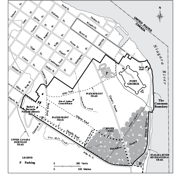
The Commons 2011.
The restored Navy Hall building is not open to the general public but is available for special meetings and private functions. The wharf is open to all and continues as a popular fishing spot and diving site. Occasionally various watercraft are allowed temporary mooring at this historic location. Fort George is open to the public throughout the year. Of the four surviving buildings of Butler’s Barracks only the two-storey barracks is open to the general public. It serves as the museum for the Lincoln and Welland Regiment. The ordnance gun shed and commissariat stores are currently used for storage. Hopefully an adaptive reuse for the 1816 Junior Commissariat Officer’s Quarters can be implemented soon. The temporary B Company building is the sole survivor of several that were constructed on site in the late 1950s or early ’60s. At least three were eventually moved offsite. The present building is currently used for storage.
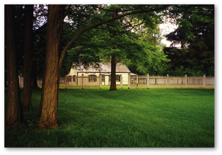
Junior Commissariat Officer’s Quarters, photo, author, 2000. What is to become of this historic 1816 building … one of the oldest surviving military residences in Ontario?
Courtesy of the author
Over the past two centuries there have been many trails that crisscrossed the Military Reserve/Commons. The oldest appears to be the byway from the John Street/Niagara Parkway intersection northwestward through the Oak Grove across the Commons, joining present Picton Street and ending at the intersection of present King and Queen Streets. Since Victorian times it has been known as the Queen’s Parade. From this now improved and slightly elevated road one can truly appreciate the wide expanse of the green Commons on both sides.
The Otter Trail, named after Canada’s first Canadian-born general in the Canadian army and long-serving commandant of Camp Niagara, General Sir William Otter, today extends from the Fort George parking lot southwest across the Commons to Butler’s Barracks. Originally this important trail passed just north of the fort’s gates and down to Navy Hall. Looking up from Ricardo Street one can still see the stone embankment that edged this road. Travelling towards Butler’s Barracks on the Otter Trail one crosses a cement bridge that was erected in 1914 by the Royal Canadian Engineers’ Corps.[5] A bit farther on the left is the site of the Indian Council House and military hospital. The Otter Trail ends perpendicular to another trail that started at the main entrance to Camp Niagara on King Street opposite Centre Street. This latter trail, known as Brock Road,[6] passed through the Butler’s Barracks complex to the original officers’ quarters where the John Street/Charlotte Street parking lot is now located. The other road/trail coming in off King Street opposite Mary Street was not opened up until the Second World War.
During the Second World War several trails were paved and named roads. Most of these roads were repaved in the 1990s to provide greater access.
There are two tree-lined trails that pass northeast parallel to present John Street. The trail closest to John Street, now known as the Sheaffe Road,[7] ran along a railway spur line. During the Camp Niagara days, thousands of soldiers arrived or departed by train. The other trail, known as the Athlone Road,[8] is not paved and is designated an off-leash site for dogs. Both the Athlone and Sheaffe Roads intersect with the Princess Alice[9] Road coming in off the second John Street entrance. This large rectangle of grass outlined by Brock, Sheaffe, Princess Alice, and Athlone Roads was the main campsite during the early militia days of Camp Niagara.
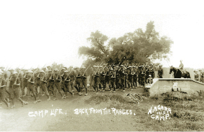
Camp Life, Back from the Ranges, photo, crossing the bridge, 1915. The cement bridge built by the Royal Canadian Engineers Corps in 1914 on the Otter Trail is still present today.
Courtesy of the author.
The new eastward extension of Sheaffe’s Road skirts Paradise Grove on the left and John Street East on the right until it reaches the intersection of the Niagara Parkway and John Street. This new trail continues into the Niagara Parks Commission’s (NPC) portion of Paradise Grove and intersects with the NPC’s Recreation Trail. Turning northward onto this trail and travelling beside the Niagara River one can continue down to Navy Hall or, halfway along, join the trail that follows around the southwestern edge of Fort George. On joining this trail one crosses between two deep ravines on either side — the remnants of the old railway cutting. The Fort George portion of the trail eventually passes the parking lot on the left and continues to Byron Street and town.
The trails of the Commons connect with three much larger trail systems. The Waterfront Trail actually begins at the Fort George parking lot (it can also be accessed at the John Street/Parkway parking lot or at the foot of Nelson Street at the river’s edge), follows the Otter Trail to Brock Road, and eventually makes its way to the Mary Street exit and follows Mary Street to the Lakeshore Road. The trail can now be followed all the way to Burlington.
A side trail of the long-established Bruce Trail begins at the John Street/Charlotte parking lot. It follows the Sheaffe Road and turns left onto the Princess Alice Road until reaching the Athlone Road. Turning right, the trail passes through Paradise Grove (passing a huge pile of earth that hopefully will be moved soon) and emerges onto the Queen’s Parade. Following southward to the John Street/Parkway intersection it hooks up to the Recreation Trail that can be followed to Queenston Heights, the official start of this trail. The Greater Niagara Circle Route follows the NPC’s Recreation Trail and the Waterfront Trail through the Commons. The fourth connecting trail is the Upper Canada Heritage Trail which follows the old railway right-of-way from York Road northward beside Railroad Street, then cross-country eventually emerging onto Charlotte and then John Streets at the western tip of the Commons, connecting with a Sheaffe Road extension.

Sunrise on the Commons.
Courtesy of Cosmo Condina.
Recently Parks Canada unveiled its own trail on the Commons, “Spirit, Combat, and Lore: A Walk to Remember.” It begins at Queen’s Parade and includes several stops where a variety of interpretative displays relate various aspects of the history of the Commons.
Given the varied and important natural and cultural landscape of the Commons as well as the historic buildings thereon, it would now seem appropriate that representation be made to have the Commons designated as an UNESCO World Heritage Site.
As we make our way across the Commons and contemplate the hundreds of thousands of military and civilian men and women who have passed this way before, we are reminded of the old biblical adage that our lives are as fleeting as the grass in the field.[10]