CHAPTER 9
MISCELLANEOUS
TABLE NR. I. CONVERSION TABLE-WEIGHTS AND MEASURES.
| MULTIPLY | BY | TO OBTAIN |
|---|---|---|
| Acres | .405 | Hectares |
| Caliber (inches) | 25.4 | Millimeter |
| Centimeters | .3937 | Inches |
| Degrees | 17.8 | Mils |
| Fathoms | 6 | Feet |
| Feet | .1667 | Fathoms |
| Gallons (U.S.) | 3.785 | Liters |
| Grains | .00228 | Ounces |
| Grams | .03527 | Ounces |
| Hectares | 2.471 | Acres |
| Inches | 2.54 | Centimeters |
| Kilograms | 2.2 | Pounds |
| Kilometers | .6214 | Miles |
| Knots | 1.152 | Miles per hour |
| Liters | .2642 | Gallons (U.S.) |
| Meters | 1.094 | Yards |
| Miles | 1.609 | Kilometers |
| Miles per hour | .8684 | Knots |
| Millimeter | .0394 | Inches |
| Mils | .056 | Degrees |
| Ounces | 437.5 | Grains |
| Ounces | 28.35 | Grams |
| Pounds | .4536 | Kilograms |
| Temperature (C) +17.8 | 1.8 | Temperature (F) |
| Temperature (F) −32 | .5556 | Temperature (C) |
| Yards | .9144 | Meters |
TABLE NR. II. AERIAL PHOTOS.
| Determining Scale: | |
| Flying Height Method: | |
Scale 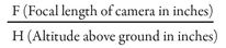 | |
| Map Distance Method: | |
Scale 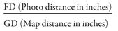 | |
| Point Designation Grid System | |
| 1. Turn photo so that written data is in normal reading position. | |
| 2. Draw lines across photo joining opposite fiducial (collimating) marks. | |
| 3. Space grid lines, starting with center lines, a distance equal to 4 cm or 1.576 inches apart. | |
| 4. Number each center line 50 and give numerical values to the other lines, increasing right and up. | |
| 5. Read coordinates as any other. | |
TABLE NR. III. LONG RANGE PHOTOGRAPHY. (35-mm Camera & Binoculars)
| Procedure. | |||
| Camera: | |||
| F Stop - | M 13 6 × 30 binoculars F 10 | ||
| M 177 × 50 binoculars F 8 | |||
| Speed - | As required by film ASA | ||
| Range - | Infinity | ||
| Binoculars: | |||
| Set left eyepiece at zero. | |||
| Sight through right eyepiece and adjust to focus. | |||
| Set binoculars to camera: | |||
| Place left monocular (with reticle) flush with camera lens. | |||
| Take picture without moving either binoculars or camera. | |||
TABLE NR. IV. MAP-DISTANCE CONVESION.
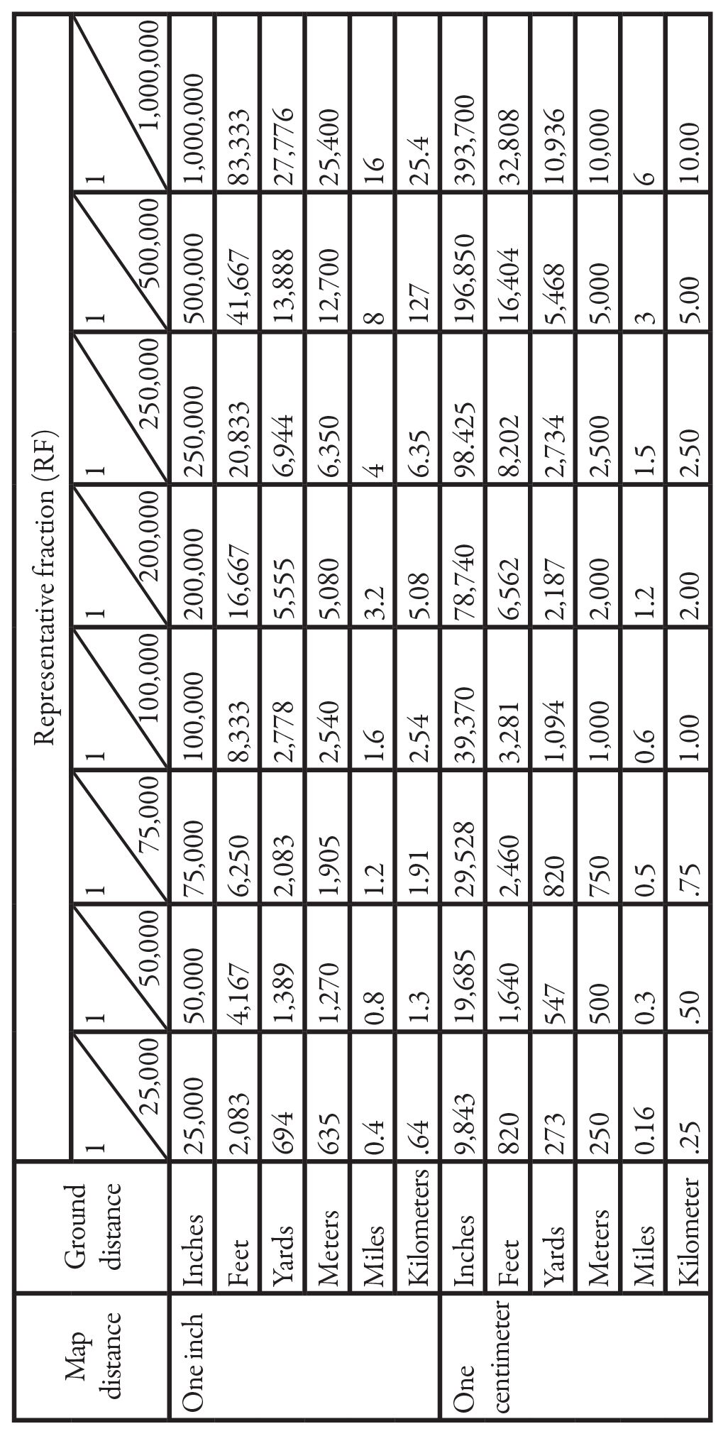
TABLE NR. V. USEFUL KNOTS.

TABLE NR. VI. MISCELLANEOUS INFORMATION.
| PRINCIPLES OF WAR | REPORTING INFORMATION |
|---|---|
| M ass | S ize |
| O bjective | A ctivity |
| S implicity | L ocation |
| S urprise | U nit |
| C ommand unity | T ime |
| O ffensive | E quipment |
| M aneuver | |
| E conomy of forces | |
| S ecurity | |
| TERRAIN ANALYSIS | PRISONERS OF WAR |
| C ritical features | S earch |
| O bservation | S eparate |
| C over and concealment | S ilence |
| O betacles | S peed |
| A venues of approach & withdrawal | S afeguarding |
| INTELLIGENCE EVALUATION LEGEND. | |
| Source | Information |
| A-Completely reliable | 1-Confirmed by other source |
| B-Usually reliable | 2-Probable true |
| C-Fairly reliable | 3-Possibly true |
| D-Not usually reliable | 4-Doubtfully true |
| E-Unreliable | 5-Improbably |
| F-Reliability unknown | 6-Truth cannot be judged |
This legend should be applied to intelligence originating in the field and the evaluation sent forward with the information.
GUERRILLA TRAINING
II. TRAINING PLAN:
- Steps in planning:
- Analysis of the mission.
- Systems for training:
- Decentralized.
- Centralized.
- Combination of Systems.
- Estimate of training situation:
- Training to be conducted.
- Personnel:
- Available for cadre.
- To be trained.
- Time.
- Training facilities.
- Training aids.
- Equipment.
- Decisions.
- The Plan.
- Principles of scheduling:
- Facilities preparation of instruction.
- Facilities learning.
- Use training time effectively.
- Accommodate the troops.
III. LEGAL STATUS OF GUERRILLAS:
- Be commanded by a person responsible for his subordinates.
- Have a fixed distinctive insignia recognizable at a distance.
- Carry arms openly.
- Conduct operations in accordance with the laws and customs of war.
IV. FOR SUCCESSFUL EMPLOYMENT OF GUERRILLA WARFARE:
- The spirit of resistance must be present in a segment of the population.
- The guerrillas must have the support of the civilian populace.
- The guerrilla movement must have a sponsor.
V. RECORDS OF GUERRILLAS:
- Personnel roster; name, rank, date joined, date discharged.
- Oath of enlistment.
- Theatre records and reports.
- Casualty reports.
- Payrolls.
- Recording and settling claims.
- Receipt forms
- Demobilization:
- Assembly of guerrilla forces.
- Collection of arms and equipment.
- Completion of administrative records.
- Settlement of pay, allowances, and benefits.
- Settlement of claims.
- Awarding of decorations.
- Care of sick and wounded.
- Discharge.
- Provisions of rehabilitation and employment of discharge guerrillas.
VI. GUIDE TO ASSESSMENT OF THE AREA:
- Initial Assessment.
- Location.
- Team morale and condition.
- Status of guerrillas (local).
- Security (local): area, attitude of local civilians, escape plan and alternate areas, enemy situation, civilian support available.
- Principal Assessment (a continuous estimate of the situation).
- Information of the enemy to include: Disposition; composition, identification, and strength; organization, armament, and equipment; degree of training, morale, and combat effectiveness; operations (recent and current activities of the unit, counterguerrilla activities, and capabilities, current security systems within the unit); unit zones of responsibility; daily routine of the units; logistical support to include: installations and facilities, supply routes, method of troop movement; past and current reprisal actions.
- Information of security troops and police units: Dependability and reliability to the existing regime and/or the occupying power; disposition; composition, identification, and strength; organization, armanent, and equipment; degree of training, morale, and efficiency; influence on an relations with the local
- Information of resistance organization: Size, equipment, organization, status of training, intelligence and logistics systems. Auxiliary, organization, status of training, general disporitions.
- Information of the civil government: Controls and restrictions (documentation, rationing, travel and movement restrictions, blackouts and curfews); current value of money, wage scales; the extent and effect of the black market; political restrictions; religion restrictions; the control and operation of industry, utilities, agriculture, and transportation.
- Information of potential targets: Railroads; telecommunications ; POL; electric power; military headquarters and installations; radar and electronic devices; highways; inland waterways and canals; sea ports; natural and synthetic gas lines; industrial plants.
- Information of the terrain: Location of area suitable for guerrilla bases, units and other Installations; potential landing zones, drop zones, reception sites; routes suitable for guerrillas and enemy; barriers to movement; the seasonal effect of the weather on terrain and visibility.
- Information of the weather: Precipitation, cloud cover, temperature and visibility; wind speed and direction; light data (BMNT, EENT, sunrise, sunset, moonrise and moonset).