The approach to Camp Century (U.S. Army)
11
Drilling
The question that tantalized Henri Bader beyond all others was what secrets the ice sheet contained in the depths below the pits that Carl Benson had shoveled out. Alfred Wegener and Paul-Émile Victor had harbored a similar curiosity about the mysteries of the deep ice, but neither had come close to finding an answer. Bader, as the head of the Army Corps’ SIPRE division, held fast to the belief that drilling into Greenland’s center, deeper than 150 feet or so, where under tremendous pressure the firn begins to squeeze together and turn to ice, could yield something miraculous.1 To his thinking, the ice sheet contained a frozen archive of long-ago events and temperatures—it was encrypted, in some yet-to-be-deciphered way, with a code to the past.
Discovering the temperature from a time before human societies maintained records, or before human civilization existed at all, is not a trivial bit of knowledge. “In the 1950s we had very limited information on temperatures from the past,” recalls one of Bader’s younger hires at SIPRE, a geologist named Chester Langway. “Very limited. And some of it was questionable. Old records from ships’ captains. Farmers with broken thermometers. It went back maybe 150 years, and with spotty numbers.”2 Langway and Bader knew, though, that if they could use the ice to somehow look further back, the questions that could be answered would be extraordinary. For instance, had a change in climate extinguished a particular species of dinosaur or mammoth? Had it prompted vast ice sheets that once covered most of northern North America and Europe to shatter into icebergs? Had it vanished the Greenland Norse from their settlements in southwestern Greenland in the 1400s? Accurate insights into ancient climates would open up a world of possibilities, not least of which was an ability to see into the causes of events that otherwise remained hazy matters of conjecture.
As he looked to Greenland, Bader was aware that scientists were already tapping other parts of the natural world for clues. By the midpoint of the twentieth century, it was becoming increasingly clear that shreds of archived history were locked within every cleft of the earth—in caves, under lake beds, and in traces of plants buried in the loam beneath bustling cities. The earth’s oceans seemed especially promising. As far back as the late 1800s, scientists had been aware that mineralized deposits from tiny sea creatures covered the bottoms of the seas. As the oceanographer John Imbrie noted, “The organic oozes had been formed over a very long period of time by the slow rain of skeletons on the sea floor.”3 Some of these layers on the ocean bottom were riddled with certain types of microscopic plankton known as foraminifera that were prevalent in warmer waters and gave an indication of warmer temperatures during a particular time period. Other layers seemed to lack these particular “forams,” as they were usually called, and were instead richer in skeletons that flourished in colder waters, and thus colder temperatures—perhaps making them an indicator of a previous ice age. In the late 1940s, Swedish oceanographers learned how to efficiently plumb down with hollow tubes and extract cylinders from the ooze; then they began using their knowledge of tiny fossilized remnants to start estimating climate changes of the past. Some researchers imagined these marine cores, striped with layers built up over time, were worth their weight in gold. Hans Pettersson, the Swedish scientist leading a global effort to scour the ocean bottom, predicted it would yield an “unrivalled archive” of the planet’s past. By probing into the seafloor “by means of tubular corers,” he predicted in 1949, “sediment columns can be raised which contain the records from tectonic, volcanic and climatic catastrophes of a remote past.”4
The study of tree rings, a branch of science that came to be known as dendrochronology, was coming into its own, too. Tree rings had attracted scientific interest in the early 1800s, at which point some scientists observed that a severe winter in Europe beginning in 1708 seemed to have led to very narrow growth rings.5 But it became an established research area in the 1930s, thanks largely to the work of Andrew E. Douglass, a scientist trained in astronomy who began looking at tree rings in the American Southwest, usually by scrutinizing samples of buried logs or old beams he found in ancient pueblo structures. He saw that the wood cross sections, which he and his associates traced as far back as the year 700, could be an excellent means of gaining insights into long-ago periods of drought and weather variation. What seemed particularly intriguing was how his studies offered more than just data about the past. They offered a way to interpret the past. By combining a new understanding of climate history with what was known about human history, Douglass remarked, it was now possible in Arizona, Colorado, and New Mexico “to correlate the increases of rainfall that permitted these villages to expand and the drought years that placed upon them the heavy hand of starvation.”6 Understanding our past climate, in other words, was a key to understanding our civilization. It might likewise shed light on the potential for climate changes in the future.
Even in the early days of paleoclimatology, as the study of ancient climates came to be known, it was clear that nature’s archives weren’t all the same. Each would have distinct virtues and shortcomings. Ocean cores, for instance, could go back far in time—likely many millions of years—and might thus offer information from very distant geological epochs. Yet these records could be difficult to date with precision, and they lacked the resolution to say much about a specific year or short period. On the other hand, tree rings seemed to promise great specificity as to what happened in a particular year, such as the chilly winter of 1708 in Europe, or the ravaging droughts that occurred in the twelfth century in the American West. But they didn’t seem to go back much further than five or ten thousand years.7 To Henri Bader, the ice sheet promised to capture a year-by-year resolution in its layers, meaning that if one could figure out how to read precise temperatures in these layers, one would find (as Bader put it) “a treasure trove.” Just as important, the layers were depositional: Everything in earth’s atmosphere had been deposited there along with the snow that turned to ice. In theory, that meant that an ice core from deep in the ice sheet would contain telltale vestiges from, say, the start of the industrial revolution, and include evidence of how atmospheric gases and pollution intensified over time. An ice core might likewise contain traces of ash that blanketed the earth after the volcanic explosions of Krakatoa in Indonesia (in 1883), Laki in Iceland (1783), or maybe even Vesuvius, near Pompeii (79). And judging by how thick the center of the ice in Greenland appeared to be, the record might go back much, much further. On the ice sheet, Bader predicted, “every snowfall, including everything that fell with it, is, so to say, separately and safely filed for future reference by being buried under later snowfalls.”8
The ice sheet, moreover, contained something that could not be found in ocean ooze or tree rings. There were bubbles of air trapped inside. Bader was not alone in this realization—during the winter of 1930–31, for instance, some members of the Wegener expedition who did not go to Eismitte camped on the western edge of the ice sheet in what they called the “winter hut.” Under their floor they dug a vertical pit, sixty-five feet deep, and scaled down on a rope ladder to see what the ice could tell them. Ideally, a scientist looking inside the Greenland ice sheet would prefer to sample an area where it is cold at all times—in the center of the island, for instance, where Ernst Sorge was digging his own shaft at the time—rather than at the periphery, where springtime melting and glacial movements could play havoc with the accumulation of layers. Still, one resident of the winter hut, Hugo Jülg, would note that the pit on the western edge seemed intriguing. He and his colleagues could make a series of temperature measurements in the shaft and measure the stratigraphy—that is, the layers—of the ice. Also, they could see “bubbles of air enclosed in the ice” which they analyzed by measuring the air pressure inside.9 Two decades later, in the late 1940s and early 1950s, Bader worked on bubbles in some of the early ice cores drilled in Alaska. “He could see the bubbles were under pressure,” his SIPRE colleague Carl Benson recalls. “And he wrote a little paper in the Journal of Glaciology called ‘The Significance of Air Bubbles in Glacier Ice.’ Now, the bubble is recording the atmosphere at the time the bubble is sealed off. And in other words, these little bubbles in the ice have a history of what the climate was like at the time. He knew this. We knew this, but it was a question of: How do you measure it?”10
Bader did not expect to find answers quickly. Inspired by the science fiction books he loved to read, he was thinking that the results from what he called “deep cores”—as opposed to “shallow” cores that went down a few dozen feet—might only be realized in the distant future. “He understood the significance of this before we even knew what we’d get out of it,” Benson says. He carried a vision that in the future glaciologists would have cores of ice stored away in special freezers—libraries of ice, in effect—and would be able to take them out for sampling and investigation. “They would put them on a light table and examine them, do chemistry and electrical and optical experiments on them.” And whatever methods were someday developed, by testing the tiny pockets of air trapped in the bubbles, and examining the trace chemicals trapped in the ice, the distant past might become all the more clear to those living in the present.
Bader was known to say: “Snowflakes fall to earth and leave a message.”11
There was reason to think that using old ice to find temperatures of the past was at least possible.
In 1931, Ernst Sorge had found that the density of snow on the ice sheet was different in summer and winter, which allowed him to count layers—and, therefore, years—with reasonable accuracy. Several decades later, as Carl Benson traveled around the ice sheet and stopped every few days to dig a snow pit, he could usually count the annual layers of snow accumulation by sight, just by looking at the strata—the thick stripes—on the wall of the pit. But to verify his conclusions Benson also called on the expertise of a Caltech professor named Samuel Epstein, who had helped develop a new method to chemically analyze snow layers.12 It so happens that not all the snow that falls on Greenland is precisely the same. To be sure, all of it is frozen water—that is, frozen H2O. But Epstein understood that the ice contains H2O molecules with tiny differences in their mass. In some snowfalls, there are more “heavy” oxygen atoms (known as 18O) that have two extra neutrons in their nuclei. These extra neutrons make them weigh slightly more than typical, “lighter” oxygen atoms (which are known as 16O). The greater abundance of 18O in some snowfalls is caused by temperature variations on stormy days and can be immensely useful for telling temperatures in the past. Epstein surmised that snow deposited in summer had more heavy oxygen isotopes than what is deposited in winter. That meant Benson could sample snow layers in the pit and send those samples to Epstein for testing, so he could be sure he was correct when he counted back through the years. “We found the oxygen isotope ratios were giving a beautiful representation of the annual units,” Benson later reported.13 And from this small demonstration, chemistry seemed a promising way to accurately count layers and perhaps find a pathway to more precisely understand ancient temperatures.14
But the problem was not only about how to interpret traces in old ice. It was how to get a deep ice core in the first place. Drilling a hole in ice at a remote location—a hole that might be thousands of feet deep—is not an easy proposition, especially if your intention is also to pull up a pristine cylinder for scientific research. By the early 1950s, there had only been four long ice cores extracted in all the world. Two were done by Paul-Émile Victor’s team in Greenland—the longer of the two went down about 450 feet. Another core measured about three hundred feet in length and was drilled by Bader at the Taku Glacier near Juneau, Alaska. A fourth core was also about three hundred feet in length and had been pulled by a British-Norwegian-Swedish Antarctic expedition on a coastal part of the frozen southern continent, near an area known as Queen Maud Land. None of these cores offered any breakthroughs in terms of explaining past climates, and some contained only fragments usable for research. What’s more, none of the projects yet made clear what equipment was best for drilling a deep ice core, or what diameter a core should be.
Henri Bader was already tapping the U.S. military to fund his science projects on snow and ice. But in the mid-1950s he saw an additional way to boost the idea of ice drilling. At that point, preparations were beginning for a global collaboration known as the International Geophysical Year, or IGY. Eventually, sixty-seven countries took part in the IGY, which was scheduled to run from July 1957 until December 1958, and which involved a dizzying array of scientific experiments on land, on ice, in the oceans, and in space. The most historic of the IGY projects involved rocketry and astronomical observations (and included Sputnik, the world’s first satellite). But a good part of the work involved multinational expeditions to Antarctica and the Arctic Ocean; in fact, IGY expeditions were the first to estimate the average depth of ice in Antarctica and prove that under all that ice was one continent.15
Bader argued strenuously that deep core drilling should be included in the American itinerary—“If the research succeeded,” he insisted, “it would be a major contribution by the U.S. to the IGY.”16 Eventually, the national committee planning the IGY agenda agreed, and Bader’s group was directed to try to drill a deep core in two locations in Antarctica. Bader believed that before that work could begin, a fair amount of preparation would need to be done, so he looked toward Greenland to try out machinery and drilling techniques. Then (as now) the island was seen as a staging ground for the more severe challenges—especially with regard to transportation and infrastructure—around Antarctica. Because of Thule, Greenland was far more accessible than in the past, and ski-equipped planes made it possible to get almost anywhere on the ice sheet in a matter of hours, weather permitting. What’s more, you could now drive right on to the Greenland ice cap by weasel or tractor. After building Thule, the Army Corps of Engineers, acting on surveys done by Paul-Émile Victor, had constructed several roads, ranging from about ten to twenty miles in length, which connected the air base to the ice sheet. Engineers had then constructed massive gravel ramps onto the ice sheet and taken the further step of filling in big crevasses on the ice sheet’s periphery and smoothing them over with snowplows.17 Knud Rasmussen had once envisioned Thule as a station that would make it easier for science expeditions to roam about the north of Greenland; by creating a small economic hub, he thought it could hasten the world’s understanding of the island. He was both right and wrong. Decades later, it wasn’t trading that made his scientific vision come to fruition but the Americans’ relentless militarization of the ice sheet.
Just as the International Geophysical Year was about to begin, Peter Freuchen died at Elmendorf Air Force Base in Alaska. He had traveled there from New York to take part in the filming of a network television special in connection with IGY activities; he intended to fly with a group of aging polar explorers from Alaska to the North Pole. “The giant bewhiskered explorer,” as one newspaper put it, had insisted on carrying his own suitcases up a staircase at his hotel. He collapsed and died on the top step.18 Freuchen was seventy-one. According to his wishes, his body was cremated and his ashes were brought to Thule, the place that he had named forty years before. The ashes were then sprinkled from an airplane flying above the old trading station, now defunct, where he and Rasmussen had lived so long ago.
Bader decided to test deep drilling at Site 2, situated on the ice sheet about 220 miles east of Thule. It was the same place where he had been stuck a few years before, when he came there to dig a snow pit and then found his plane couldn’t take off again. But Site 2 was different now: it had a new radar station and, under Bader’s direction, a hundred-foot-deep research pit, which had been dug into the ice sheet in the summer of 1954—with chainsaws, shovels, and picks.19 Not far from the pit, army engineers had also begun to dig long tunnels so as to measure how quickly dug-out areas were deformed over time by the weight of falling snow and the movement of the ice sheet. Usually eighteen people were stationed at the camp, a group that included American military personnel along with a few SIPRE engineers and scientists. The U.S. military had essentially picked a point on the map—quite literally the barren middle of nowhere—and decided to see if it could, with the force of technology, money, and willpower, make it useful.
Although there are a few existing photographs, it is difficult to conjure what day-to-day life was like in an outpost so remote and forsaken that it existed for only a few spectral years, and was thereafter crushed by decades of accumulating snow. If you were staying at Site 2 in the early 1950s, you had access to electricity, hot water showers, a mess hall, and barracks. You had a Ping-Pong table and recreation area. You were not living in a normal army camp, however. Almost all the living areas were located within prefabricated housing units that had been assembled inside giant corrugated metal pipes that measured eighteen feet in diameter. The Army Corps of Engineers had trucked the corrugated steel across the ice sheet to Site 2 and then assembled it, believing the pipes to be a good means of testing how to prolong the life of an Arctic military installation, especially as yearly snowdrifts buried it.20 Site 2, at an altitude of seven thousand feet, was therefore an experiment in ice sheet living. At the same time, it was also an experiment in human resiliency, with residents having little to do on bitter days except venture out of “the tubes” to make measurements on local ice sheet conditions. Weather interruptions often made radio contact with Thule impossible. Even with occasional visitors, ample rations, warm bunks, and frequent movie nights, the loneliness of Site 2 caused some men to break, especially in the dead of winter when storms meant no mail or flights could come in. One journalist described Site 2 as “among the most lonely and isolated habitations on the face of the earth.”21
Chester Langway arrived at Site 2 in the summer of 1956. He was hired by Bader a few days after finishing his master’s degree in geology at Boston University—in fact, Langway graduated on May 15 of that year, and on June 1 he was ordered to take a flight from McGuire Air Force Base in New Jersey to Thule in Greenland. He had not intended to study ice or work in the Arctic; he had not even been aware that ice drilling existed, or that it was deemed an important part of the upcoming International Geophysical Year. Langway recalls: “On that first trip we went out from Thule to Site 2 on what they called a ‘swing’ ”—Greenland jargon for an ice sheet convoy—“on a tractor that was about six or seven feet tall, with 58-inch tracks. These were huge machines that pulled six or eight sleds and fuel for the tractors.” The tractors moved slowly—two or three miles per hour—and the journey took several days. When Langway arrived, he and his team were assigned to live and work a few miles from the tubes of Site 2, in insulated Jamesway huts that resembled huge half-barrels nestled in the snow. “The army fed us and sheltered us and built us a camp,” says Langway, “and that was the route to success.”22
Langway’s primary job was to catalog and analyze the ice cores, rather than to oversee the drilling process, which was the responsibility of the engineers and technicians. Not long after the SIPRE crew arrived, they cut a deep trench with plows, roofed part of it with wood for protection from storms, and began setting up the ice drill, which resembled a small derrick and was so tall it couldn’t be covered by the roof but instead needed to poke into the open air above the snow line. The men had decided to extract a core by using a Failing-1500 rock driller adapted with special hollow drill bits that SIPRE engineers surmised would work for cutting through ice.23 The entire process was arduous. “At Site 2,” Langway recalls, “all you did was work, eat, and sleep—seven days a week until you finished.” His team stayed three months. By the end, they had reached a depth of nearly 1,000 feet. But half of the ice core they brought up was broken and unusable, and the work—constantly connecting and disconnecting drill pipes and equipment every time they brought the bit to the surface—was slow and frustrating.
They returned the following year, in June 1957. This time things went better. The engineers were now pulling ice cores that looked usable and intact. And when Henri Bader visited as the summer season was ending, he seemed pleased. He took Langway aside to ask him some questions.
“Chet, it’s getting dark now, it’s getting late, and we’re down now almost four hundred meters,” Bader said. “That’s the deepest ever. And the core is pretty good. Do you want to go to Antarctica?”
Langway hadn’t been thinking of much else but Greenland for the past year and a half.
“When?” he responded.
“October,” Bader said. That was his way of saying he was considering bringing Langway into the IGY drilling projects.
“October of what year?” Langway asked.
“Next month,” Bader said.24
When his shock receded, Langway said no. He knew that part of the deal of working as a researcher at SIPRE was that you lived a life of perpetual winter. Summers were spent in the field in the Arctic, then you endured Chicago’s cold seasons. And when buds appeared on the trees, it was time again to go back to the Arctic. But if Langway were to sign on to the IGY project in Antarctica, it would mean nine more months of constant drilling, constant work, constant cold. And what he most wanted was to spend time in the SIPRE lab in Illinois, trying to figure out what to do with the ice from Site 2. By the end of drilling, the SIPRE team had reached a depth of about 1,350 feet. The cylinders they recovered varied in length from six inches to one and a half feet and were just shy of four inches in diameter. Each had been carefully cataloged and numbered as it came to the surface, so that Langway could trace a continuous record of the past.
Many years later, researchers would establish protocols for analyzing ice cores: There would be precise instructions as to how to slice and saw them, both crossways and lengthwise, and how to measure out wedges and crescents and cubes so that certain cuts could be dedicated to specific methods of physical, chemical, and optical analysis. At this early moment in time, however, there was no protocol. At Site 2, Langway had a makeshift laboratory in one of the Jamesway huts where he conducted preliminary tests on the core. By counting the visible layers, he was now fairly sure that he had reached back about nine hundred years, meaning the deepest parts of the core were made from snow that fell at the time that the colonies of the Greenland Norse were still thriving. He had measured the core’s temperature and density; he had looked at the stratigraphy through a light table, which highlighted the seasonal changes in snowfall. He had focused on understanding how the deeper cores were affected by pressure from bubbles of air inside, which seemed to make the ice brittle when it came to the surface. But in the end, he concluded he could do far more back home and decided to saw all the pieces of core in half, lengthwise, and bring a large portion of it, packed in dry ice, to a cold lab in Illinois.25
A few months after returning to the United States he wrote a report about the Site 2 drilling project that was published in the Journal of Glaciology. He listed all the tests he planned to conduct next on the core—for more precise dating; for determining the pressure, shape, and distribution of air bubbles; for understanding the ice’s permeability and porosity; for considering isotopic quantities of oxygen, deuterium, and tritium inside. He even noted he would make an effort to look for bacteria trapped within. He seemed willing to throw everything he could think of at the ice, scientifically speaking, with the hope it could somehow prove demystifying. And Langway suggested that SIPRE was open to still other suggestions, since no one knew for sure how to decode an ice core anyway. “Interested persons,” he wrote at the conclusion of his article, “are cordially invited to submit proposals for further studies.”26
The two IGY drillings in Antarctica did not reach the same depths as the hole at Site 2. But these projects convinced the scientific establishment that drilling deep cores was a promising endeavor, even if the ice couldn’t yet be properly interpreted.27 The question for the glaciologists was what to try next. Chester Langway would recall that by the end of 1958 the discussions at SIPRE turned to the idea of developing an ice-coring system “capable of reaching bedrock depths.”28 Bader was setting his sights on extracting a top-to-bottom core from one of the world’s two major ice sheets, with the intention of seeing how far back in time he could go. His plan was to drill first in Greenland, rather than Antarctica. Again there were two main reasons. Thule provided tremendous advantages for travel and infrastructure. And because the Cold War continued to escalate—especially in the months after Sputnik was put in orbit—part of the military’s enormous Arctic budget remained at Bader’s disposal.
Bader hitched his plan to drill a hole through the Greenland ice sheet to a very different idea concocted by the U.S. military’s Cold War strategists—one which involved building a massive new base under Greenland’s ice. This was fairly typical. Much of the work Bader’s organization had already done in Greenland had been in conjunction with the U.S. military’s construction plans. In 1957, for instance, as Chet Langway and his team were drilling at Site 2, the Army Corps of Engineers was conducting a program, also near Site 2, that involved building a small under-ice camp named Fist Clench. Rather than being housed within giant corrugated pipes, Camp Fist Clench was situated in deep, wide trenches that had been cut into the top layer of the snow and firn. More specifically, army engineers had dug four parallel trenches that they then bisected with a central trench. These deep cuts, twenty feet deep and eighteen feet wide, were then covered over with metal arches.29
It was an experiment. To cut the trenches atop the ice sheet, Bader suggested that the Army Corps of Engineers use a machine called the Peter snow miller—a tractor-like snowblower that could clear a wide, crisp path through even the deepest snowfall, and which served as a workhorse for road crews in Switzerland, Bader’s country of birth. His associates made tests at Fist Clench to show that the Peter miller was extremely adept at cutting deep trenches. And after the trenches were covered over by metal arches, engineers used the Peter miller to blow surface snow back over the shiny roofs.30 This “Peter snow,” as those at SIPRE called it, would quickly bind into a dense, durable roofing material—so durable and strong that Bader’s researchers determined the Camp Fist Clench arches could even be removed, if necessary, so that some of the test trenches there resembled narrow church naves. Inside these long white alleyways, lit by electric lighting, it was blindingly bright, with ice crystals glittering on the walls and roof.
The spaces did not remain empty long, though. Within the completed Fist Clench trenches, the Army Corps of Engineers assembled prefabricated huts for barracks, mess halls, and storage spaces—leaving room under and around these huts for cold air circulation. This was part of the experiment, too. In sum, the engineers seemed intent on demonstrating whether there was an efficient way for the army to build Eismitte after Eismitte. Several decades before, Sorge and Georgi had realized the firn of the ice sheet could protect humans from bitter cold and ravaging winds. The military now surmised that with snow and ice it could camouflage soldiers and armaments from the prying eyes of an enemy’s aerial observations.
All of this served as preparation for what came next.
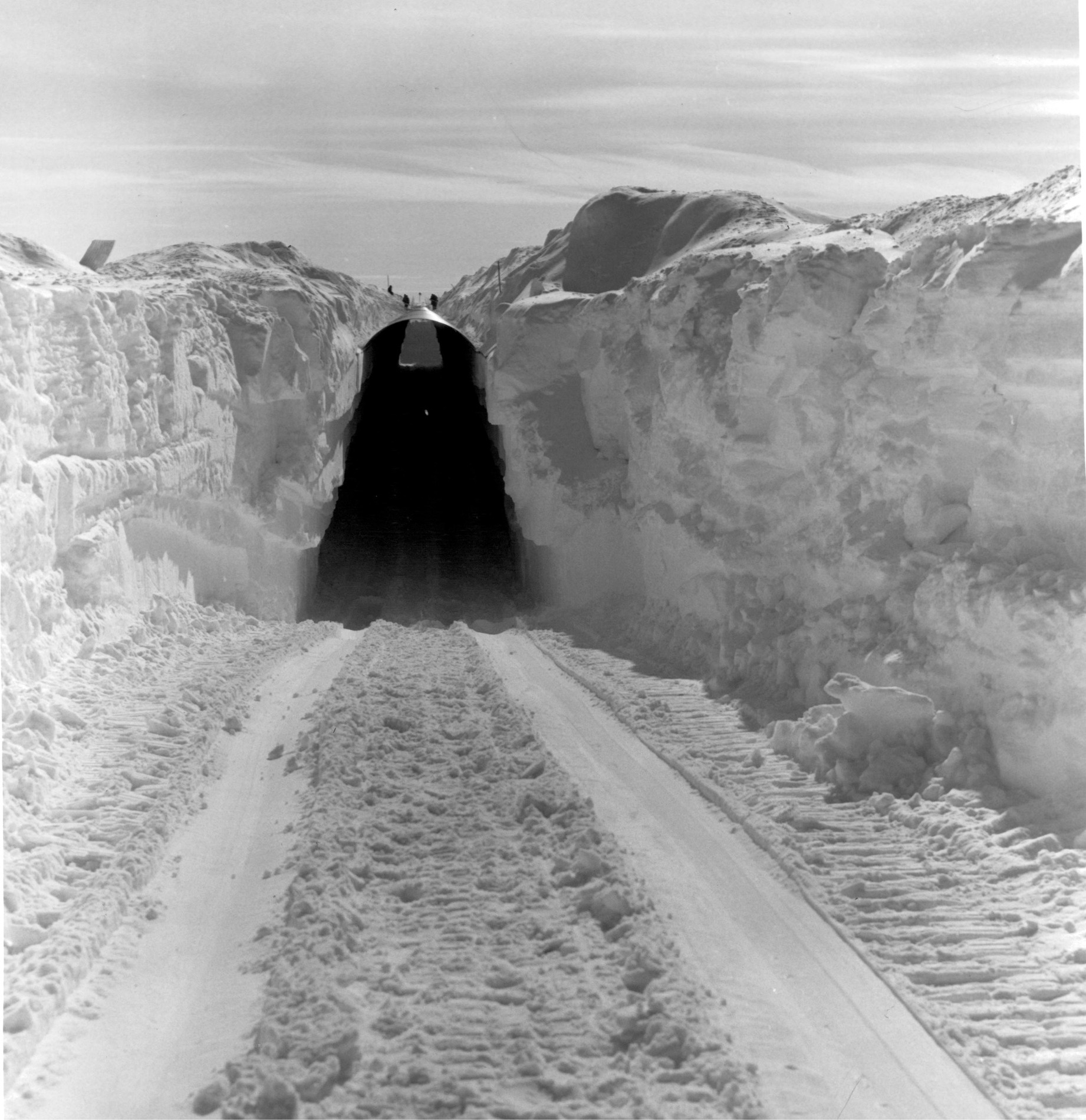
In 1961, a British physicist named John Nye flew from Suffolk, England, to Washington, D.C.; and from Washington, Nye took a military flight to Thule Air Base in Greenland. Amongst glaciologists, Nye was famous for a number of academic papers he wrote in the 1950s that explained how glaciers and ice sheets flow—his observations showed that large bodies of ice behave like a plastic that “deforms” to a new shape under gravity and various stresses. Nye was visiting Greenland as a guest of Bader, to see what life was like under an ice sheet. From the Thule base he traveled about fourteen miles to the edge of the ice sheet, where a ramp to the ice was located; from there, he and a group of soldiers boarded a “wanigan”—a heated, insulated trailer hitched to a massive Caterpillar tractor, which would be part of a convoy known as a “heavy swing.” Their destination was a point on the ice sheet 138 miles from Thule.31 Here, the lessons from Site 2 and Fist Clench had been directed to a new under-ice station, known as Camp Century, which the army had built between June 1959 and October 1960.32
On a heavy swing, you slept, you chatted, you ate steaks grilled in the kitchen. Though it was possible to fly from Thule to Camp Century and land on a runway of groomed snow, often such flights were limited to army officers or to clergy who flew in briefly on Sunday to conduct religious services.33 So instead, in the wanigan, you looked out the windows in boredom and in wonder for three or four days—or sometimes six or seven days, when bad weather intruded—as the panorama of ice stretched on and on. And on. The U.S. Army had built an ice road to the camp, lined with flags, emergency huts, and emergency supplies, and thanks to a new type of electrical crevasse detector, fitted to the front of each tractor, the journey had become fairly safe. Any resemblances to the travails of earlier explorers like Wegener or Rasmussen had mostly vanished. “It took three days,” Nye would recall of the heavy swing, putting the speed at about two miles an hour, or slightly slower than the walking pace of a human being. The tractors and wanigans “rumbled over the snow and ice, and sleeping in them was very like being in an express train going at about eighty miles an hour with that sort of noise.”34 The sound came from the crunch of the wanigan’s sledge runners on the ice sheet. When the tractor finally reached Camp Century, it descended down an entrance ramp—not unlike a car pulling into an underground parking garage—and motored into the camp’s interior. What Nye saw was a place similar in concept to Fist Clench, a hidden catacomb of snow and ice, but far, far larger.
A high, wide, long tunnel—more than a thousand feet long, big enough to serve as a road for the tractors, and known as “main street”—ran the length of the camp. Perpendicular to main street, about two dozen long trenches had been cut in parallel to thirty-foot depths by the Peter miller. All the trenches were covered with metal arches and topped with snow. Within the side tunnels, the army installed prefabricated huts; all told, they held the capacity to house about two hundred and fifty soldiers and scientists. Camp Century contained an officers’ club, a mess hall, showers, toilets, barracks, a church, and a store; you could drink beer or whisky on Saturday nights, read one of the books in the four-thousand-volume library, or watch movies. A haircutter named Jordon, the self-proclaimed “best barber on the ice cap,” charged enlisted men fifty cents for a chop and officers one dollar.35 The ambient temperature under the ice was well below zero, but the huts stayed at a pleasant 65 degrees Fahrenheit. To avoid having to tow massive amounts of fuel from Thule to the camp, however, engineers eventually installed a small, experimental nuclear reactor in an under-ice trench to provide electricity. The reactor cost $5.7 million and weighed 310 tons. It was towed on sled runners—gently, in the late summer of 1960—by Caterpillar tractor over the ice sheet.
The same year Nye traveled to Camp Century, the American television news anchor Walter Cronkite visited, too. Cronkite endured a similar ritual: the multiday haul from the edge of the ice sheet by wanigan; the wide-eyed surprise at the scale and audacity of the camp; and the glimpse—now shared with a television audience of millions—of a pint-sized nuclear reactor and the army’s strange and exhaustive efforts to make life under the ice sheet comfortable. The military brass was forthright about the fact that Camp Century was doomed. At best it would last ten years, they acknowledged, at which point the overburden of snow would push down on the roof, push in on the walls, and thus destroy it. For the time being, though, officials strained to present the camp as a project built in the spirit of national defense and scientific inquiry—“as part of man’s continuing efforts to master the secrets of survival in the arctic.”36 In fact, when Cronkite asked Tom Evans, Camp Century’s commanding officer, about his objectives, Evans rattled off three: “The first one is to test out the number of promising new concepts of polar construction. And the second one is to provide a really practical field test of this new nuclear plant. And, finally, we’re building Camp Century to provide a good base, here, in the interior of Greenland, where the scientists can carry on their R & D activities.”37
At that point in time, some researchers and soldiers working at Century were aware this was not entirely true, and that one goal of the camp was unrelated to exploring the viability of ice sheet habitation. In a horseshoe-shaped, under-ice trench about a quarter mile from the main camp, and not open to visitors like Nye and Cronkite, an Army Corps engineer named Gunars “Chuck” Abele was experimenting by moving massive hunks of pig iron on a flatbed rail car—thousands of pounds of raw metal meant to approximate the weight of an intermediate range ballistic missile (IRBM). “We found there was no problem doing that,” recalls Austin Kovacs, an engineer working nearby at Camp Century. “The firn was more than capable of supporting the load.”38 Wayne Tobiasson, an engineer working at Camp Century at the time, remarks: “That was something going on there that made no sense to us. And there was never an explanation except: Can we build tunnels and runways in Greenland?”39
Several decades after Camp Century was abandoned, a study by the Danish Institute of International Affairs uncovered a 1962 memo that detailed a U.S. military proposal for what was known as the Iceworm system: A nuclear arsenal of six hundred IRBMs, targeted toward the Soviet Union, which could be moved around under the Greenland ice sheet by rail. A blueprint for a project that was never built, Iceworm involved “thousands of miles of cut and cover tunnels twenty-eight feet beneath the ice” where “Iceman” warheads “would be in constant motion.” The installation was expected to cover an area of the ice sheet that historian Erik D. Weiss approximated as the size of the state of Alabama.40 In light of how the hollowed-out tunnels at Century were subject to the powerful and crushing dynamics of the Greenland ice sheet, the idea would come to seem preposterous in later years. Almost as soon as Camp Century was built, in fact, an entire crew of men had to be assigned to wander the camp corridors to shave and trim the encroaching snow from the tunnels. They removed as much as forty tons of firn from the walls every week. And yet, in the few but feverish years of Cold War strategizing, a contingent within the military not only thought Iceworm was possible, they thought it ingenious.
The irony was that Henri Bader and his colleagues were actually using Camp Century for an inspired research project. It just happened to be a research project that the U.S. Army didn’t care as much about. In Trench 12, the Camp Century drilling crew, led by an engineer named Lyle Hansen, had set up a new rig. “The army allowed us to freeload with them,” Chet Langway, who was in charge of cataloging and analyzing the ice cores that Hansen’s drill brought up, recalls. And since the army was maintaining the appearance that the camp was for scientific research rather than for nuclear missile research, officials at Camp Century welcomed the prospect of showing visitors what the drillers were doing. Nye himself visited the early stages of the drilling project, as did Cronkite. “We were sort of a cover, if you will,” Langway says, even though his team’s goal—to reach bedrock—was deeply serious.41
The drilling group made some test holes, with mixed results, in 1961 and 1962. Then the effort to go from top to bottom began in earnest in October 1963. Bader estimated the distance was about a mile down. He expected the drilling team would reach near to bedrock—by his guess, ice that fell as snow seventy-five thousand years before—in four months.42