17
Polity Instability Models Featuring Ethnic and Nationalist Insurgence
Starting in the late 1990s, Lars‐Erik Cederman conceptualized the bottom‐up approach to political insurgence phenomena. Several simulation platforms, GeoSim1 and the advanced versions GeoContest2 and GROWLab,3 were developed for modelling purposes. GeoSim defines states as agents, with no internal structure. Further developed simulation platforms approach the polity as a structured agent or as an artificial society. The models developed in this late paradigm are characterized by a geographically situated approach to polity modelling, in which territory is represented as a spatial grid allowing the simulation of territorial fractionalizing processes.
A typical approach is the two‐level hierarchical polity – that is, centre and subordinated periphery groups – in which the main criteria of differentiation between the individual agents and between groups is ethnicity. Polity’s geographical position, terrain, borders and neighbouring states are addressed as dynamic features and/or factors of the model.
Geopolitical Strategic Competition, GeoSim
The state is defined as a territorial agent, which interacts with other individual and group agents. The competition for power amongst the state agents in an agent‐based system is described by means of individual interactions governed by simple rules. Owing to the complexity of an agent‐based system with multiple interactive state agents, the dynamic evolution of these interactions features a process of balance of power with multiple local and global equilibria, but with high sensitivity to the relationship between the leading state agent (central) and all the other agents (periphery or group agents) competing for power. The description of interaction between states as individual agents in an agent‐based system was inspired by the early model of geopolitical competition developed by Bremer and Mihalka (1977) and by Axelrod (1995).
GeoSim (Cederman, 2003) models the war amongst several state agents in a multicountry geopolitical region, where the ‘country’ agent is viewed as a state agent. GeoSim features a system with the states as individual agents which have only local interactions (i.e. with adjacent neighbour states only) (see Figure 17.1).
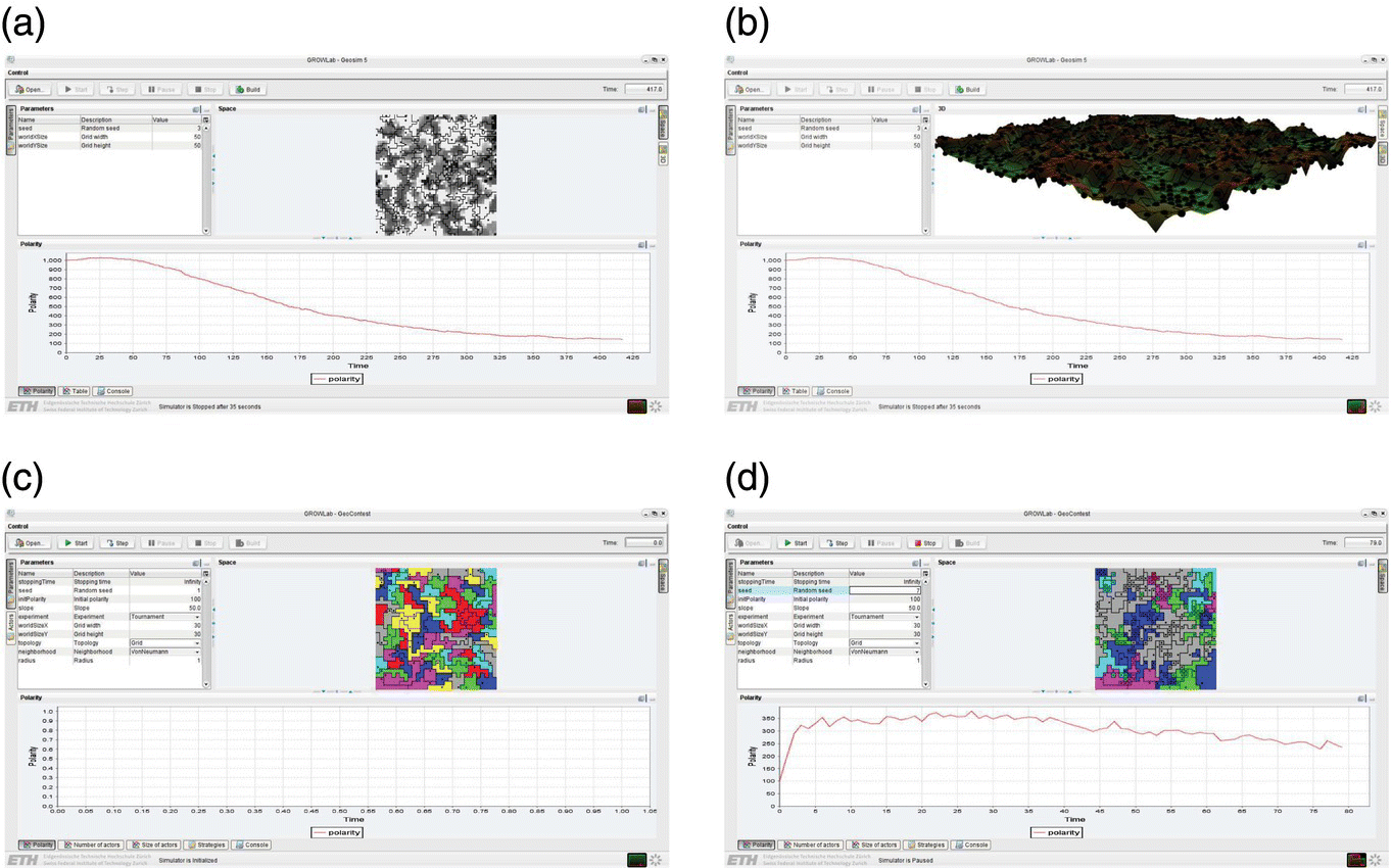
Figure 17.1 GeoSim (Cederman, 1997) and GeoContest (Weidmann and Cederman, 2009). (a, b) GeoSim Model and (c, d) GeoContest demo simulations of the interactions between neighbourhood states. Both models could be employed for geopolitical strategy design. The snapshots were obtained by running demo simulations, which were performed with the GROWLab platform, GROWLab v. 0.9.4 for Windows (56 MB); GeoSim and GeoContest are available for download as options within the GROWLab platform: http://www.icr.ethz.ch/research/growlab/box_feeder/download. GeoSim and GeoContest accessed, downloaded and run: 24 July 2015. See the Web Resources section for this chapter.
For each state agent the power game is to take other states as subordinates, thus increasing power with an increase in the number of subordinated states until equilibrium of power is reached. As soon as the equilibrium is lost (and it is quite often as the system is highly sensitive to variations in the centre–subordinate relationships), the power contest between state agents starts again.
Nationalist Insurgency Model
The GeoSim model was adapted to another type of hierarchical state and to another type of power contest process: a state agent is defined as a unitary system comprising a unique centre of power (located in the capital city) and multiple provincial agents who are subordinated to the state agent. The centre–periphery structure allows for (a) an empire state–national states hierarchy approach and (b) a state–provinces hierarchy approach. Both polity structures allow for the study of increasingly emphasized nationalist tendencies of the national states which are trying to balance the power of the centre state. Both structures are based on the same logic of potential conflict in which a subordinated state (in the first alternative) or a province (in the second alternative) rebels against the centre state. This version of the GeoSim model, called the Nationalist Insurgency Model, NIM (Cederman and Girardin, 2007a,b), has been used in exploring ethnic nationalist insurgency cases.
Conceptual Basis of Conflict Modelling
As hypothesized by Fearon and Laitin (2003), rebellions and nationalist insurgency are characteristic of weak states which cannot exercise control over their territory and thus provinces or subordinated states might become conflict generative. Their theory emphasizes the role of a territorial control mechanism in generating conflict between top and lower levels of a state hierarchy (centre–periphery).
The NIM model was meant to prove an alternative to their classic insurgence theory: Cederman (2008) showed that the same results could be obtained in a centre–periphery hierarchical structured state with a different mechanism, namely, ethnicity and nationalism. NIM simulations (Cederman and Girardin, 2007a, b) show that a hierarchically structured state is conflict prone if it fails (a) in the nationalist mobilization of its periphery toward common societal goals and (b) in generating collective actions based on a shared cultural (national) identity. In a state organized as a centre–periphery hierarchy with a multi‐ethnic demographic composition and ethnic distribution of the access to power, the mechanism of ethnicity and nationalism will always function by providing support to the nationalist ethnic coalitions of the provinces against the centre of power.
In order to model the configurations of ethnic political groups and their relationships with the phenomena of civil violence (i.e. from uprisings to civil war), the modelling starts from a few hypotheses which synthesize the modelling conceptual framework.
- H1 (state ownership): The main hypothesis is that ethnicity and nationalism acquire a political significance when they are directly related to state and power, an idea inspired by the fundamental theories with regard to insurgence and nationalism (Geertz, 1963; Tilly, 1996). This hypothesis allows for taking the first dimension of modelling: civil conflict arises from competition for the state power and resources.
- H2 (political exclusion of ethnic groups): When demographically significant ethnic groups (ethnic minorities) are excluded from state power, they become conflict prone and are more likely to generate civil violence. If ethnic groups are defined on a collective identity criterion, then the exclusion of ethnic groups from state power might degenerate into civil conflict. This tendency to generate conflict might drive state failure, like in the case of ex‐Yugoslavia, where the multi‐ethnic group composition competing for state power and resources resulted in state failure (state disintegration).
- H3 (mobilization): A state which fails in mobilizing all ethnic groups on a common identity dimension fails as well in preventing and/or avoiding civil conflict. Mobilization is based on three essential factors in the model which reinforce polity resilience to stress sources like the struggle for power between (ethnic) groups: (1) collective identities, (2) collective actions and (3) shared motivations. As a complex entity, the polity stability depends on the balance of power between the structural groups involved in the power competition (Tilly, 1978). As collective actions succeed in aggregating these groups, their mobilization provides for a balance of forces competing for power such that the polity avoids instability.
These hypotheses involve, in a rather qualitative way, the issue of political attitudes, beliefs and values which might provide for an enhanced definition of both collective identities and collective action. Though the authors do not address these issues, this does not mean that they are not involved in the qualitative aspects of the simulation outcomes.
Computational and Simulation Modeling of Spatial Conflict Emergence
The NIM model provides for nationalist insurgency outcomes by means of three characteristic features:
First, a terrain model is introduced, so that the type of the terrain becomes a dynamic factor which controls the relationship between centre and periphery.
Second, there is a multidimensional culture dissemination map, similar to that defined in Axelrod’s (1997) Culture Dissemination Model. This feature is meant to support the idea that the cultural groups are distributed in a cultural landscape in which the groups may be identified by their national identities.
A representation of the cultural identity as a dynamic feature providing for the clustering of individuals in ethnic–nationalist groups based on their common national identities is different from the classic idea that computational and simulation modelling of culture (identity and traits) is about fixed properties influencing the social and political behaviour of the individual agents (Axelrod, 1997; Epstein, 2002). This allows for a political approach to both identities and the dynamics of the groups with common ethnic nationalist identities which describe a cultural space.
Third, the conventional indices of ethnicity (ethno‐linguistic fractionalization) are replaced by the Expert Survey of Ethnic Groups, ESEG4 index of ethno‐nationalist exclusiveness which associates ethnic configurations with political violence. As a model of ethno‐nationalist civil war, the N* index consists of an ethno‐political configuration (C*) and a mechanism (M*). The model identifies the ‘star’ ethnic configuration and the opportunity‐based mechanism which provides for collective actions as the means to mobilization across ethnic identities (see Figure 17.2). The ESEG index5 has been constructed so that the simulation runs are based on empirical data which mirror the degree of exclusion of ethnic groups from power in all states of the world (the index has been constructed on a questionnaire basis and used in the computational modelling of dyadic relationships with empirical data6).
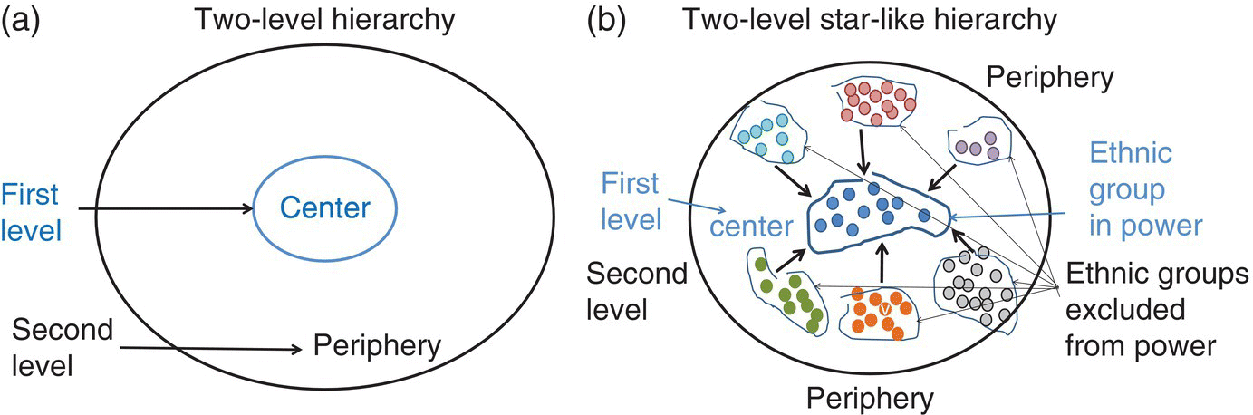
Figure 17.2 A simple scheme featuring the ethnic group hierarchical distribution in NIM. (a) Hierarchy levels: centre and periphery. (b) Polity is modelled as a star'like, two‐level hierarchy of ethnic groups.
GROWLab: Advances in the Computational and Simulation Modelling of Spatial Conflict Emergence
The GROWLab Geographic Research on War Laboratory, GROWLab (Weidmann and Girardin, 2006; Cederman and Girardin, 2007b), is a new generation of geopolitical simulation platforms which includes modules for modelling, simulation, analysis and validation of social processes with a special focus on civil unrest and civil and regional wars. The simulation platform is based on the concepts of configurations as generative terms (Cederman, 2005).
The GROWLab design of computational model defines three basic operational concepts for the computational description and simulation of polity, polity structure, territory, topology, neighbourhoods and the interactions and relationships between agents: layer, topology and configuration (Figure 17.3).
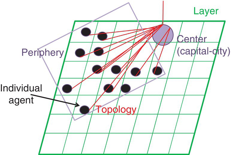
Figure 17.3 GROWLab concepts for polity modelling. Basic concepts: layer, topology, configuration.
The layer is the basic type of description. It defines the individual agent. A layer contains all agents of a given type. It represents, therefore, a collection of identical agents. In a layer, the same functionalities and abilities are defined for all agents. The layer represents the design of an individual agent. It comprises the internal representations of an individual agent, its capacities of processing information, communication and learning, and it generates data as it performs its tasks. A mapping is the layer which maps agents and spatial locations. It helps in constructing the space as a set of spatial locations. A space could be defined as a grid (a bounded space based on a matrix of cells) or as a torus (circular space).
Each layer (class of agents) has a topology, which defines and describes the neighbours, the spatial location of an agent, the spatial distance between any two spatial locations in the territory and the repertoire of relationships between the individual agents. A topology is a way of associating an individual agent with a spatial location and with any other agent temporarily in any other spatial location of the polity’s territory. A topology provides for the calculation of any distance given two agents of interest for the user.
The configuration is a class of procedures which allows for creating hierarchies of agents regardless of the layer to which they actually belong. A configuration is a procedure which works across agents and topology types and could connect any two agents in any layer. A configuration is used for building up the model structure.
A polity (‘state’ or ‘country’) is therefore represented as a territory (space) with sharp boundaries (borders), with a number of individual agents (homogeneously or heterogeneously defined).
The simulations consist of constructing the GROWLab model of an abstract polity making use of its concepts and specifying the hierarchical structure, the functions of each entity in the model (agents, territory, etc.), their relationships and so on. Each simulation run employs the empirical data (ESEG index data, GIS data). The simulations generate other data which are stored and processed separately and also visualized with separate components.
Cederman’s approach on the agent‐based modelling of geopolitical conflicts is theoretically based on the Simmelian concept of ‘social forms’ which underlies the generative paradigm employed in the bottom‐up models of social complexity (Simmel, [1908]1955, [1908]1971; Cederman, 2005). The basic concept in the Simmelian‐inspired generative approach to social and political complexity is the configuration, meant to replace the traditional concept of system. The configuration is an emergent structure whose dynamic behaviour is dependent on context and history. The GROWLab philosophy includes three basic concepts which define the types of configurations used in the model design. The layer is a local‐level, interactive type of structure that defines individual agents of the same type. The topology is a relational configuration that defines the spatial relations, which could be defined in a fixed‐territory population polity. It evaluates any spatial distance between any two agents. Finally, the configuration defines the structure of a polity. The configuration of a model is a structure constructed from local types of layers.
Web Resources
ETH Swiss Federal Institute of Technology Zurich, International Conflict Research
GeoSim: http://www.icr.ethz.ch/research/geosim.
GeoContest – Simulating Strategies of Conquest (contact person: Nils Weidmann): http://www.icr.ethz.ch/research/geocontest.
GROWLab (contact persons: Nils Weidmann and Luc Girardin): http://www.icr.ethz.ch/research/growlab.
References
- Almond, G.A., Jr, Bingham Powell, G., Dalton, R.J. and Strom, K. (2006) Comparative Politics Today: A World View. Pearson Longman, New York.
- Axelrod, R. (1995) A model of the emergence of new political actors. In N. Gilbert and R. Conte (eds), Artificial Societies: The Computer Simulation of Social Life. University College Press, London.
- Axelrod, R. (1997) The Complexity of Cooperation: Agent‐Based Models of Competition and Collaboration. Princeton University Press, Princeton, NJ.
- Bennett, S.D. (2008) Governments, civilians, and the evolution of insurgency: modeling the early dynamics of insurgencies. Journal of Artificial Societies and Social Simulation, 11(4), 7. http://jasss.soc.surrey.ac.uk/11/4/7.html. Accessed: December 17, 2015.
- Bremer, S.A. and Mihalka, M. (1977) Machiavelli in Machina: or politics among hexagons. In K.W. Deutsch (ed.), Problems of World Modeling. Ballinger, Boston, MA.
- Cederman, L.‐E. (1997) Emergent Actors in World Politics: How States and Nations Develop and Dissolve. Princeton University Press.
- Cederman, L.‐E. (2003) Modeling the size of wars: from billiard balls to sandpiles. American Political Science Review, 97(1), 135–150.
- Cederman, L.‐E. (2005) Computational models of social forms: advancing generative process theory, American Journal of Sociology, 110(4), 864–893.
- Cederman, L.‐E. (2008) Articulating the geo‐cultural logic of nationalist insurgency. In S. Kalyvas and I. Shapiro (eds), Order, Conflict, and Violence. Cambridge University Press.
- Cederman, L.‐E. and Girardin, L. (2007a) Beyond fractionalization: mapping ethnicity on nationalist insurgencies. American Political Science Review, 101, 173–185.
- Cederman, L.‐E. and Girardin, L. (2007b) Toward realistic computational models of civil wars. Paper prepared for presentation at the Annual Meeting of the American Political Science Association, Chicago, 30 August–2 September. http://www.icr.ethz.ch/publications/cederman2007towards.pdf. Accessed: December 20, 2015.
- Cederman, L.‐E., Girardin, L. and Wimmer, A. (2006) Getting ethnicity right: an expert survey on power distributions among ethnic groups. Paper prepared for presentation at the Annual Convention of the American Political Science Association, Philadelphia, 30 August–3 September. http://www.princeton.edu/~awimmer/ESEG_APSA_Paper%20final.pdf. Accessed: December 17, 2015.
- Cederman, L.‐E., Weidmann, N.B. and Gleditsch, K.S. (2011) Horizontal inequalities and ethno‐nationalist civil war: a global comparison. American Political Science Review, 105(3), 478–495.
- Cederman, L.‐E., Wimmer, A. and Min, B. (2010) Why do ethnic groups rebel? New data and analysis. World Politics, 2(1), 87–119.
- Choucri, N., Electris, C., Goldsmith, D., Mistree, D., Madnick, S.E., Morrison, J.B., Siegel, M.D. and Sweitzer‐Hamilton, M. (2006) Understanding and modeling state stability: exploiting system dynamics. Working paper CISL# 2006‐02. http://ic3.mit.edu/ResearchSamples/2006‐02.pdf. Accessed: December 15, 2015.
- Cioffi‐Revilla, C. and Rouleau, M. (2009) MASON AfriLand: a regional multi‐country agent‐based model with cultural and environmental dynamics. In Proceedings of the Human Behavior–Computational Modeling and Interoperability Conference 2009, HB‐CMI‐09, Joint Institute for Computational Science, Oak Ridge National Laboratory, Oak Ridge, Tennessee, USA, 23–24 June.
- Cioffi‐Revilla, C. and Rouleau, M. (2010) MASON RebeLand: an agent‐based model of politics, environment, and insurgency. International Studies Review, 12, 31–52.
- Cioffi‐Revilla, C., Luke, S., Parker, D.C., Rogers, J.D., Fitzhugh, W.W., Honeychurch, W., Frohlich, B., DePriest, P. and Amartuvshin, C. (2007) Agent‐based modeling simulation of social adaptation and long‐term change in Inner Asia. In T. Terano and D. Sallach (eds), Advancing Social Simulation: The First World Congress in Social Simulation. Springer Verlag, Tokyo.
- Cioffi‐Revilla, C., Rogers, J.D., Wilcox, S.P. and Alterman, J. (2008) Computing the steppes: data analysis for agent‐based modeling of polities in Inner Asia. In Proceedings of the 104th Annual Meeting of the American Political Science Association, Boston, MA, 28–31 August.
- Dahlgren, P. (2013) The Political Web: Media, Participation and Alternative Democracy. Palgrave Macmillan, Basingstoke.
- Doran, J. (2005) Iruba: an agent‐based model of guerrilla war process. In K.G. Troitzsch (ed.), Representing Social Reality, Pre‐proceedings of the 3rd Conference of the European Social Simulation Association (ESSA), Koblenz, Germany, 5–9 September; pp. 198–205.
- Epstein, J.M. (2002) Modeling civil violence: an agent‐based computational approach. Proceedings of the National Academy of Sciences, 99(Suppl.), 7243–7250.
- Epstein, J.M. and Axtell, R. (1996) Growing Artificial Societies: Social Science from the Bottom Up. MIT Press, Cambridge, MA.
- Fearon, J.D. and Laitin, D.D. (2003) Ethnicity, insurgency, and civil war. American Political Science Review, 97, 75–90.
- Geertz, C. (1963) The integrative revolution. In C. Geertz (ed.), Old Societies and New States: The Quest for Modernity in Asia and Africa. Free Press of Glencoe, New York.
- Gellner, E. (1983) Nations and Nationalism. Cornell University Press, Ithaca, NY.
- Gurr, T.R. (1993) Minorities at Risk: A Global View of Ethnopolitical Conflicts. United States Institute of Peace Press, Washington, DC.
- Hirose, K., Imai, K. and Lyall, J. (2014) Can civilian attitudes predict civil war violence? Paper prepared for the 1st Asian Political Methodology Meeting, Tokyo Institute of Technology, 6–7 January. http://ssrn.com/abstract=2446168≥ or <http://dx.doi.org/10.2139/ssrn.2446168. Accessed: December 15, 2015.
- Hoff, J., Horrock, I. and Tops, P. (eds) (2000) Democratic Governance and New Technology: Technologically Mediated Innovations in Political Practices in Western Europe, ECPR European Politics Series 9. Routledge, London.
- Howard, Ph.N., Duffy, A., Freelon, D., Hussain, M., Mari, W. and Mazaid, M.M. (2011) Opening closed regimes: what was the role of social media during the Arab Spring? Working paper 2011.1. http://philhoward.org/opening‐closed‐regimes‐what‐was‐the‐role‐of‐social‐media‐during‐the‐arab‐spring/. Accessed: December 15, 2015.
- Kollman, K.W. and Page, S.E. (2006) Computational methods and models of politics. In L. Tesfatsion and K.L. Judd (eds), Handbook of Computational Economics, vol. 2: Agent‐Based Computational Economics, Handbooks in Economics Series. North‐Holland/Elsevier, Amsterdam; Chapter XX.
- Kollman, K.W., Miller, J.H. and Page, S.E. (eds) (2003) Computational Models in Political Economy. MIT Press.
- Lang, J. and De Sterck, H. (2012) The Arab Spring: a simple compartmental model for the dynamics of a revolution. http://arxiv.org/abs/1210.1841. Accessed: December 17, 2015.
- Lynch, M. (2012) The Arab Uprising: The Unfinished Revolutions of the New Middle East. Public Affairs, New York.
- Lynch, M., Glasser, S.B. and Hounshell, B. (eds) (2011) Revolution in the Arab World: Tunisia, Egypt, And the Unmaking of an Era. Slate Group, Washington, DC.
- Mishler, W. and Pollack, D. (2003) Thick‐and‐thin: a neo‐cultural synthesis. In D. Pollack, J. Jacobs, O. Muller and G. Pickel (eds), Political Culture in Post‐Communist Europe. Attitudes in New Democracies. Ashgate, Aldershot; Chapter 13, pp. 237–256.
- Mitsutsuji, K. and Yamakage, S. (2006) A generic simulation model of the relationship between state‐entities: sovereign states, empires and confederations. http://yamakage‐ken.com/?p=73. Accessed: December 17, 2015.
- Nisbet, E.C. and Meyers, T.A. (2010) Challenging the state: transnational TV and political identity in the Middle East. Political Communication, 27, 349.
- Pickel, A. (2006) The Problem of Order in the Global Age: Systems and Mechanisms. Palgrave Macmillan, London.
- Pollack, D., Jacobs, J., Muller, O. and Pickel, G. (eds) (2003) Political Culture in Post‐Communist Europe. Attitudes in New Democracies. Ashgate, Aldershot.
- Sakamoto, T. (2013a) Exploring spatial dynamics of civil conflicts in virtual Africa: a new research design. CDR Quarterly, 8, 28–58.
- Sakamoto, T. (2013b) Conflict analysis in virtual states (CAVS): a new experimental method based on the extensive use of multi‐agent simulation (MAS) and geographical information system (GIS). JICA‐RI working paper 56, pp. 1–27.
- Sakamoto, T. and Endo, M. (2015) Multi‐agent simulation of state collapse and reconstruction: analyzing the past and the future of Somalia. Working paper no.46. http://yamakage‐ken.com/?p=210. Accessed: December 17, 2015. Paper accessed with Dr Takuto Sakamoto’s agreement, which is hereby gratefully acknowledged.
- Shirky, C. (2011) The political power of social media. Foreign Affairs, 90(1), 28–41.
- Simmel, G. ([1908] 1955) Conflict and the Web of Group‐Affiliations, transl. by K.H. Wolff and R. Bendix, New York: Free Press.
- Simmel, G. ([1908] 1971) How is Society Possible. In D.N. Levine (ed.), Georg Simmel: On Individuality and Social Forms, Chicago: University of Chicago Press.
- Tascón, M. and Quintana, Y. (2012) Ciberactivismo. Las Nuevas Revoluciones de las Multitudes Conectadas. Los libros de la Catarata, Madrid.
- Tilly, C. (1978) From Mobilization to Revolution. McGraw‐Hill, New York.
- Tilly, C. (1996) The state of nationalism. Critical Review, 10, 299–306.
- Van de Donk, W. (2000) Infocracy or Infopolis? In J. Hoff, I. Horrocks and P. Tops (eds), Democratic Governance and New Technology, Technologically Mediated Innovations in Political Practices in Western Europe. Routledge, London; pp. 138–154.
- Vogt, M. (2011) The ethnic power relations dataset (EPR‐ETH) v2.0. http://www.icr.ethz.ch/data/other/epr‐2.0/epr‐eth_v.2.0_codebook.pdf. Accessed: December 17, 2015.
- Voinea, C.F. (2012) Briberyscape: an artificial society‐based simulation model of corruption emergence and growth. In C.F. Voinea (ed.), Political Attitudes and Mentalities. The Historical Heritage of Europe: A Challenge for the Future of Political Analysis. Ars Docendi‐University of Bucharest Press, Bucharest; pp. 113–148.
- Voinea, C.F. (2014) On mechanism, process and polity: an agent‐based modeling and simulation approach. European Quarterly of Political Attitudes and Mentalities, 3(3), 15–45. https://sites.google.com/a/fspub.unibuc.ro/european‐quarterly‐of‐political‐attitudes‐and‐mentalities/Home/eqpam‐volume‐3‐issue‐no‐4‐october‐2014. Accessed: December 17, 2015.
- Weidmann, N.B. (2009) Geography as motivation and opportunity: group concentration and ethnic conflict. Journal of Conflict Resolution, 53(4), 526–543.
- Weidmann, N.B. and Cederman, L.‐E. (2009) GeoContest: modeling strategic competition in geopolitical systems. Social Science Computer Review, 26(4), 510–518.
- Weidmann, N.B. and Girardin, L. (2006) GROWLab: a toolbox for social simulation. http://www.agsm.edu.au/bobm/teaching/SimSS/Vol2/10StudentSession/15.pdf. Accessed: December 17, 2015.
- Weidmann, N.B. and Salehyan, I. (2013) Violence and ethnic segregation: a computational model applied to Baghdad. International Studies Quarterly, 57(1), 52–64.
- Yamakage, S. (2009) Modeling and Expanding Artificial Societies. Introduction to Multi‐Agent Simulation with artisoc. Kozo Keikaku Engineering, Tokyo.