4 Lyell Canyon
SCENERY: 
TRAIL CONDITION: 
CHILDREN:  (shorter distance would be appropriate for children)
DIFFICULTY:  (mileage is flexible, as this is an out-and-back hike)
SOLITUDE: 
DISTANCE: 5–11 miles out and back
HIKING TIME: 3–5 hours
OUTSTANDING FEATURES: Stunning meadows, views of Kuna Crest, trout fishing
This out-and-back is an easy Sunday stroll and a perfect spot for beginning hikers, families, or anyone desiring a lazy amble in an amazingly beautiful setting. If we had to introduce skeptical friends to the joys of lacing up hiking boots, this would be the trail to pick. The trail is mostly flat, but boasts picture-perfect meadows framed by granite monoliths, as gorgeous as any you may find in at Yosemite National Park. Usually you have to really work to afford a view like this.
DIRECTIONS: The Lyell Canyon trailhead is in the Tuolumne Meadows area of Yosemite National Park off Tioga Road (CA 120). For parking, follow signs to the Tuolumne Lodge and Wilderness Permit office. There is a parking lot on the left signposted for Dog Lake and the John Muir Trail, or you may find additional parking in the Wilderness Permit lot and then follow the signs to the John Muir Trail. The park runs a free shuttle-bus service from 7 a.m. to 6:30 p.m. along Tioga Road from Tuolumne Lodge to Olmsted Point from July 4 through Labor Day; the Lyell Canyon trailhead can be found at Shuttle Stop #2. Additionally, YARTS bus service offers a shuttle from Tuolumne Meadows Visitor Center back to the Yosemite Village Visitor Center at 9:10 a.m. during the summer months. Rates are $15 one-way. Contact YARTS by phone at (888) 89-YARTS or visit www.yarts.com) for current rates and schedules.
| GPS coordinates | Lyell Canyon | |
| UTM zone (WGS84) | 11S | |
| Easting | 0294479 | |
| Northing | 4194386 | |
| Latitude | N 37°52′39.09″ | |
| Longitude | W 119°20′32.58″ |


 This is an out-and-back walk, so you can truly make it as long as you’d like. The flattest section of the John Muir Trail, this path would be quick walking if it weren’t for the fact that you undoubtedly will want to stop and take pictures, soak in the beauty, and perhaps take a dip in the river’s cool waters.
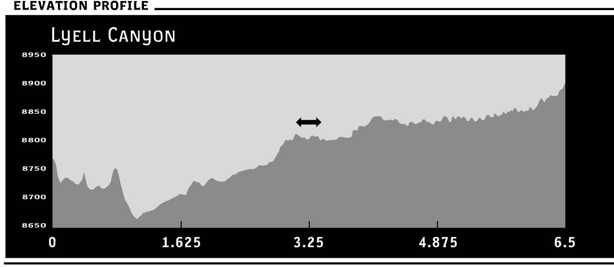
From the Dog Lake Parking Lot (8,700 feet), cross the road and follow signs to the John Muir Trail. After half a mile, cross a bridge over the Dana Fork of the Tuolumne River. Shortly thereafter, a second bridge takes you over the Lyell Fork. About 1.5 easy miles from the trailhead, traverse rushing Rafferty Creek on a handsome footbridge (8,720 feet), and begin a beautiful stroll in and out of forest thickets and along the grassy expanse of Lyell Canyon. The area is named for Charles Lyell, a 19th-century lawyer turned geologist and good friend of Charles Darwin.
Up until the mid-1800s, with its outpouring of prospectors and explorers, Native Americans were the only people to enjoy the beauty of this region. Miwok and Mono Indians stopped in the area to trade during the summer en route east. After early adventuring pioneers found silver in the Tioga Mine, the area bustled with mining activity for several years. Today, the area still sees both a fair amount of trade and modern prospecting in the retail shops of the park.
The area is particularly lush in early season with an explosion of fiery wildflowers. Late April through mid-November, rainbow trout lure anglers to this stretch of Yosemite, while day hikers and picnickers hunker down by the river year-round.
The trail alternates between shady pockets of pine trees and open meadows, never rising more than 300 feet as it parallels the Lyell Fork of the Tuolumne River. The canyon is quite wide, so while there are imposing granite walls lining the meadow, it feels very open. Enjoy stunning views of the famed Unicorn Peak and farther along, Mount Lyell, the park’s highest peak at 13,114 feet.
After crossing Rafferty Creek, reach your next trail junction in a little more than 4 miles at the turnoff (8,900 feet) for Ireland Lake and the designated return spot. Your walk brings you within feet of the shallow and gently flowing river that has been carving this valley for millions of years. Sometimes the water tumbles over giant rock slides, other times it meanders through grassland, and often it swirls into deep blue-green pools that invite a stop. Return the way you came, savoring views of Mammoth Peak and the Kuna Crest.
The trail’s proximity to busy Tuolumne Meadows, as well as its level grade, nearly guarantees that you will have company in this part of the wilderness. The presence of hikers careless with their food, combined with shallow waters teeming with fish, also means that this is popular bear and deer country. Be sure to keep your food secure at all times.
PERMIT INFORMATION: No permits necessary for day hikes