3 Red’s Meadow to Vermilion Valley Resort
SCENERY: 
TRAIL CONDITION:
CHILDREN: 
DIFFICULTY: 
SOLITUDE:
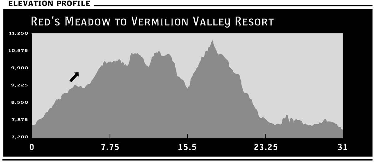
DISTANCE: 31 miles
HIKING TIME: 3–5 days
OUTSTANDING FEATURES: Red Cones, Purple Lake, Lake Virginia, Squaw Lake, Silver Pass, Pocket Meadow, Edison Lake Ferry
This section travels from the relative creature comforts of one backcountry refuge to another. You’d be wise to enjoy this pampering as the trail becomes increasingly more remote as it meanders south. From Red’s Meadow, it’s a long, hot, and sometimes exposed climb through an area ravaged by 1992’s Rainbow Fire. However Purple and Virginia lakes provide the perfect setting for a high-altitude swim to wash off any trail dust. Enjoy a tremendous descent into Tully Hole and walk along the banks of Fish Creek, rolling up toward Squaw Lake. Silver Pass (10,895 feet) is the most significant climb of this stretch, affording epic views of Cascade Valley. From here, it’s virtually all downhill as the trail wanders through Pocket Meadow before descending to Lake Edison. Hop on a ferry that whisks you away to cold beer and hot food at the Vermilion Valley Resort. The “resort” part is a bit of a stretch—it’s no Four Seasons—but they’ve got tent cabins, showers, and great eats.
DIRECTIONS: RED’S MEADOW RESORT—Red’s Meadow can be reached from Mammoth Lakes. From the Mammoth Ranger Station and Visitor Center (on CA 203, 3 miles west of US 395), head west on Main Street for 1.5 miles and turn right to continue on CA 203 (Minaret Road), climbing nearly 5 miles to Mammoth Mountain Inn.
During the summer months, you cannot access Red’s Meadow or the Devils Postpile National Monument via car from 7 a.m. to 7:30 p.m. unless you have campground or resort reservations, a handicap placard, or a special permit. Wilderness Permits do not allow you vehicular access. Mandatory shuttles operate from the parking area in front of Mammoth Mountain Inn beginning at 7:15 a.m. Tickets can be purchased at the Gondola Building in the Main Lodge; the 45-minute shuttle to the Devils Postpile area is free for children under age 3, $4 for children ages 3 to 15, and $7 for adults. Shuttle service within the national-monument area between campgrounds and trailheads is free; Red’s Meadow Resort and Campground is Shuttle Stop #10. For more information, contact the Mammoth Ranger Station and Visitor Center at (760) 924-5500 or visit www.ci.mammoth-lakes.ca.us/transit/regional_transit.htm.
If you have reservations or are traveling in the off-season (October to early June), continue driving up the hill to the Minaret Summit Entrance Station (9,175 feet) and follow the steep, narrow road the remaining 7 miles to the Devils Postpile Monument Area, Red’s Meadow, trailheads, and campgrounds.
Public transit is available to Mammoth Lakes along US 395 between Reno and Ridgecrest via Inyo Mono Transit’s CREST bus. The bus travels north between Bishop and Reno via Mammoth Lakes on Tuesday, Thursday, and Friday, and south between Mammoth Lakes and Ridgecrest on Monday, Wednesday, and Friday. There is also limited Saturday service between Bishop and Mammoth Lakes only. Rates and routes are subject to frequent change; call ahead for information and reservations at (760) 872-1901 or (800) 922-1930. More information can be found on the Web at www.countyofinyo.org/transit/CRESTpage.htm.
Public transit also services the route between Yosemite and Mammoth Lakes. YARTS buses leave from various points in Yosemite to Mammoth Lakes once daily between 5 p.m. and 6:50 p.m. ($15; approximately two hours each way). Contact YARTS at (888) 89-YARTS or visit www.yarts.com for current rates and schedules. This does, however, force an overnight in Mammoth Lakes.
To take advantage of these public-transit options, you must travel the 4 miles between Mammoth Mountain Inn, where the Red’s Meadow Shuttle drops you, and the city of Mammoth Lakes, from which the CREST and YARTS buses depart. This can be done via the Bike Park Shuttle that operates from 9 a.m. to 5:30 p.m. daily, late June through September. The bike shuttle runs from the Mammoth Lakes Village transportation hub (Minaret Road at Canyon Boulevard) to the Adventure Center located across the street from Mammoth Mountain Inn. This service is free for hikers.
Lastly, you could contact Mammoth Shuttle by phone at (760) 934-6588 to arrange for private transit on demand. This is a pricey option but may be worth it for larger groups. Prices range considerably from $100 (from one eastern-Sierra trailhead to another) to $600 (from Mammoth to Kings Canyon). The price to go from Mammoth to Yosemite averages $200 (per eight-passenger shuttle, not per person).
VERMILION VALLEY RESORT—To get to Vermilion Valley Resort (VVR), you will most likely need a friend to pick you up or try your hand at hitchhiking. The closest main highway is CA 168, 30 miles northeast of Fresno, but the final 14 to 20 miles of your journey is a feat to be applauded. VVR even makes a T-shirt that boasts “I survived the drive up to VVR” if that’s any indication to you of the conditions of the road. It can be done in just about any car, but be prepared for some interesting (and stunning) rough-road driving.
From Prather, take CA 168 north to the first stop sign. Turn left to stay on CA 168 past Shaver Lake and Sierra Summit Ski Resort. At Huntington Lake, turn right for Edison Lake and follow a good road for 6 miles. The next 14 miles are on an intimidating and winding one-lane road with potholes the size of small craters and lots of gravel. Allow at least two hours from this juncture. It appears as if they did not move a single boulder or tree in the creation of the road, thus it remains absolutely one lane the whole way, despite the fact that it takes traffic in both directions. Rest assured that there are pull-outs along the way. The first feat is going over Kaiser Pass (9,128 feet), then the road drops for close to 3,000 feet, only to climb close to another 2,000 feet back up to the lake level. It is not recommended to drive this road at night, and it’s highly encouraged to have snow chains on hand year-round. A mile past the U.S. Forest Service High Sierra Ranger Station, take a left to head toward Edison Lake. Roll down and then up the mountain and follow a sign that reads “Vermilion Valley Resort 2 miles.” Congratulations—you’ve arrived! And you thought the hard part was the hiking….
| GPS coordinates | Starting trailhead Red’s Meadow Resort | |
| UTM zone (WGS84) | 11S | |
| Easting | 0316915 | |
| Northing | 4165147 | |
| Latitude | N 37°36′51.37″ | |
| Longtitude: | W 119°04′30.50″ | |
| Ending trailhead Lake Edison Ferry Landing | ||
| UTM zone (WGS84) | 11S | |
| Easting | 0328251 | |
| Northing | 4141859 | |
| Latitude | N 37°24′26.21″ | |
| Longitude | W 118°56′26.24″ |
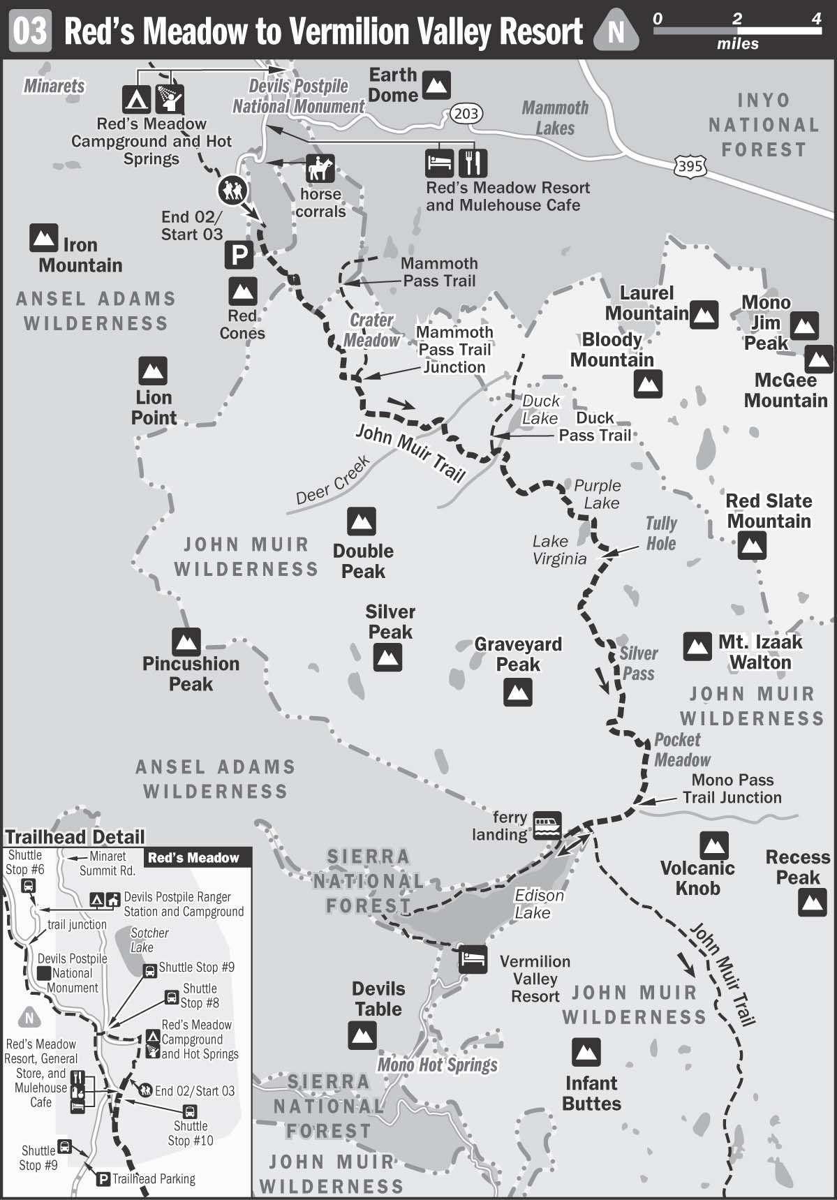
 From Red’s Meadow Resort (7,600 feet), the John Muir Trail (JMT) isn’t initially clear: To access the route, walk through the horse corrals and continue southeast on the unmarked trail. Within a quarter mile reach a sign for the Pacific Crest Trail (PCT) and shortly thereafter follow the route marked to Red Cones.
Traverse the wide, dusty basin through manzanita, aspen trees, and waist-high ferns, noting the havoc wreaked by the Rainbow Fire. Named for nearby waterfalls, the blaze swept through the region in 1992, scarring close to 8,000 acres in its lightning-induced wake. Now the remaining tree snags provide excellent roosts for an abundance of birds, including the brightly coated Western Tanager. The opened canopy, dotted with lodgepole pines, allows for a greater diversity of ground cover and a fiery display of wildflowers. Consider wearing pants on the first stretch of this trail, as the low foliage is narrow, dense, and somewhat scratchy.
Begin climbing a series of switchbacks under the welcome shade of more mature trees ascending above the fire zone. Cross several small branches of Boundary Creek before rising to the lovely plateau below Crater Meadow, where Indian paintbrush, asters, and monkey flower abound. Continue rising along the sandy, pumice-laden trail and enjoy views of the backside of Mammoth Mountain.
A dormant volcano, Mammoth lies on the rim of Long Valley Caldera, a region that is known as one of the Sierra’s “hot spots” due to ever-present geothermal activity. Ironic, considering that Mammoth is a mecca for snow sports in the winter. Considered young, as it was formed by numerous eruptions between 220,000 and 50,000 years ago, Mammoth is part of the same magmatic chain as the Red Cones, volcanic cinder cones named for their rich red color. The reddish hue is a result of scoria deposits on their mantle, and carbon dating places the unglaciated cones at just under 9,000 years old.
A side trail to Mammoth Pass veers off to your left (northeast) shortly before you cross Crater Creek (8,920 feet) and leave Ansel Adams Wilderness to enter John Muir Wilderness. Walk a short spell along an idyllic creek lined by fir trees and lupine, and come through a shady plateau into gorgeous Upper Crater Meadow. Red’s Meadow now lies 4 miles away. Traverse a few streams on raised earthen bridges before entering the woods and resuming a moderate climb. Reach popular campsites at the crossing of Deer Creek (9,150 feet). Be sure to load up on water here, as the next water source lies nearly 6 miles away at Duck Creek.
Resume ascending gently in the shade of trees. Rising closer to 10,000 feet, stunning views of the Silver Divide mountains reveal themselves through the conifers to your right. Rounding the ridge above Cascade Valley, drop down toward Duck Creek, noticing a number of popular campsites as you approach the ford of Duck Lake’s outlet. Flat tent sites can be found on either side of the creek.
After the Duck Lake outlet crossing, begin mounting a series of rocky exposed switchbacks. Mule trains are not uncommon here as they travel to the pack station at Red’s Meadow. Ignore a side trail to Duck Pass veering off to the left before reaching the top of the saddle (10,460 feet), and follow signs to Purple Lake. Walk along a sandy ridge, moderately shaded with pine trees, and enjoy sweeping views over Cascade Valley to the snow-capped mountains beyond. Begin dropping toward Purple Lake with manzanita lining the rocky path.
Purple Lake (9,928 feet) sits in an exquisite tree-lined cirque. There is great camping here, although it’s popular with stock horses and mule trains, so less private than other areas. After skirting the lake on the southern shore, ignore a sign to Marsh Lake and follow a subsequent JMT sign, crossing a wooden bridge over the lake’s outlet and begin climbing again. The switchbacks from Purple Lake are superbly well engineered, albeit not effortless. The first bit is intermittently shaded, but then there’s a long exposed section that can be brutal in the hot sun. Reach a high point at 10,500 feet, for fabulous vistas and the whirring sound of dragonflies, before dropping down moderately toward Lake Virginia (10,338 feet). The lake is dazzling, but also very exposed and frequently quite windy; making it great for keeping the mosquitoes at bay but a bit chilly for swimming. There are some exposed campsites here. Continuing on, the outlet can be difficult to cross, but well-placed rocks should guide the way amid a field of vibrant Indian paintbrush.
Switchback up, skirting the lake’s northeast shore, and continue past reddish granite rocks tumbling toward the shore. Traverse a rather flat, sandy wash section before beginning a dizzying descent toward Tully Hole (9,520 feet). Long, exposed, vertigo-inducing zigzags lead to the meadow below with expansive views ever present. At the bottom, follow rushing Fish Creek as it tumbles over rocks. There are plenty of places to camp along here.
Ignore McGee Pass junction and continue following signs to Silver Pass. Cross a steel footbridge to find more camping sites and the junction with the Cascade Valley Trail. Continue straight and begin ascending up the shady path toward Silver Pass. It’s a long climb, continually along the creek, with lush wooded sections and several creek fords. Water is plentiful, and the canyon is dark and moist with intermittent campsites. The path steepens just below the upper rocky basin that cradles Squaw Lake. Climb nicely cut granite stairs and enjoy marvelous backward views. Squaw Lake (10,300 feet) sits nestled in a dramatic granite amphitheater. There are a few scrubby pines amid the grass and a handful of exposed campsites with stellar sunset views. Cross the lake’s northwestern outlet to continue climbing. It’s 1.5 miles and 600 feet of ascension from here to the top of Silver Pass.
Climb 300 feet to junction with Goodale Pass Trail and the Lake of the Lone Indian. The scenery is spartan and expansive, and it’s possible to camp here. Keep climbing until the trail plateaus a bit near Chief Lake set among scrubby boulders and tarns and cradled by grand craggy mountains. Catch your breath before the next series of switchbacks and admire the views back toward Papoose Lake. Approach the pass through an exposed broad cirque. Much of the year the final push to grand Silver Pass (10,900 feet) requires traversing a snowfield.
You may notice that the snow has a pinkish hue. The Sierra Nevada range is well known for its high-altitude “watermelon snow,” a phenomenon resulting from an algae bloom that thrives in cold temperatures. The scientific term is Chlamydomonas nivalis, and if you compress the snow under your boot or make snowballs, the reddish tint is heightened. Despite the sweetish watermelon scent from which the snow derives its name, it is ill-advised to taste the pink snow, as it’s rumored to cause severe gastrointestinal issues. As a general rule, it’s best to never eat colored snow—pink, yellow, or otherwise!
To truly appreciate the view from the pass, climb the higher rocks to the western side of the pass and soak in an eyeful of breathtaking snowcapped mountains and lakes. Essentially, it’s all downhill from here, more than 3,000 feet, all the way to Edison Ferry, 8.5 miles away. Say good-bye to the Inyo National Forest and descend into Sierra National Forest on the southern side of the pass.
Hike down past the gorgeous turquoise waters of an unnamed mountain tarn, where there is little to no camping, and continue through boulder-strewn grasslands to lovely Silver Pass Lake, to find several fine campsites. This is very exposed country with little shade but tremendous views.
The descent moves from open exposed area to wooded meadow and finally down precipitous switchbacks to the North Fork Mono Creek. Continue down, down, down steep and loose rock. The final descent toward the river can be a bit of a knee buster, with two challenging fords that require caution: one at Silver Pass Creek and the other over the North Fork Mono Creek. After crossing the river this second time, continue descending and ignore the trail to Mott Lake. The JMT skirts briefly away from the water to enter shady Pocket Meadow, where campsites are plentiful.
Enjoy a more moderate descent along the creek, and meander through waist-high monkey flower and grasses dotted with Yosemite asters and black-eyed Susans. Water tumbles over smooth slabs of granite, and sunlit meadows give way intermittently to aspen groves and wooded thickets. As the view opens up, begin switchbacking down again, ignoring the Mono Creek Trail and continuing to follow signs to Selden Pass. After this juncture, the trail becomes nearly flat. Cross the river and walk through shaded stands of cool pine trees with a few gentle rises thrown in to break up the monotony of the descent.
At the juncture in Quail Meadows, a trail to the left heads across a bridge to continue on the JMT toward Selden Pass. Instead, leave the JMT briefly and head straight toward Edison Lake. Relatively flat and shady, the trail uses wooden plankways to protect the more fragile grasslands. Continue 1.4 miles to reach another juncture. The trail straight ahead travels the 4.8 miles to Vermilion Valley Resort, skirting the northwestern shore of Lake Edison. Most hikers, however, choose to turn left and walk another quarter mile to reach the ferry landing (7,720 feet). En route, pass camp spots and lots of good slabs for sunning or lunching, with water cascading over the rocks.
Ferries depart from this landing from June 1 to October 1 (seasonally dependent on snowpack) at 9:45 a.m. and 4:45 p.m. for the 20-minute journey. Regular rates are $10 one-way, $15 round-trip, although private ferry trips can be arranged in advance through Vermilion Valley Resort. There is decent swimming near the northern outlet that feeds into Edison Lake if you have to wait a while. Sometimes this area is choked with fishermen, but it’s invariably a friendly crowd, and a great place to wash off the trail dust before reaching the relative oasis of great food, cold beer, hot showers, laundry facilities, and general merriment of Vermilion Valley Resort.
Vermilion Valley Resort (VVR) was established in 1994 by Butch and Peggy Wiggs. It quickly became known as a home away from home for JMT and PCT thru-hikers. While, sadly, Butch passed away in 2001, the resort has retained its open-armed welcome to the weary and dirty that find their way to its rustic charm. Indeed, they still offer a free bed and a beverage to all thru-hikers, along with one of the lowest rates for their food-cache storage and delivery (see more information on sending food).
The general method is to start a tab at the front desk of the sundries store. Put all your meals, showers, laundry, phone usage, ferry tickets, and beverages on a tab and then pay with plastic or cash before you leave. Be forewarned, however, that your tab can add up quickly! The general store has a small selection of vital items (food, sunscreen, bug spray, bandages, ponchos, fishing gear, iodine tablets for water purification), but it’s no full-blown equipment store. There is a scale outside the store to weigh your pack—and many load theirs up for bragging rights here.
Loud and friendly, VVR is not necessarily a place of restful solitude, but for many it’s the perfect antidote to many miles spent hiking the quiet backcountry. Campfires, drunken sing-alongs, and newfound friends are de rigueur. There is also a frequently picked-through hiker’s barrel with up-for-grabs food and clothing that other hikers have unloaded or donated. If there are no tent cabins available, simply pitch a tent in what they have dubbed “Sherwood Forest,” essentially the patch of dirt and trees in front of the parking area. It may not be the most beautiful spot you’ve ever camped, but it’s within stumbling distance of the flush toilets, showers, and restaurant, and most are happy to call it home.
The most memorable aspect of VVR is hands-down their fantastic food—homemade pie, rib-sticking barbecue, and always a veggie option for any noncarnivores. Befitting with the eclectic character of the place, their chef had a prior life as a tenured philosophy professor at UC Berkeley before switching gears and enrolling in culinary school.
PERMIT INFORMATION: Permits that originate in the Inyo National Forest can be reserved by contacting the Wilderness Permit Reservation Office (351 Pacu Lane, Suite 200, Bishop, CA 93514), open 8 a.m. to 4:30 p.m. daily from June 1 to October 1 and Monday through Friday during the rest of the year. You can reserve over the phone at (760) 873-2483, by fax at (760) 873-2484, or by mail. You will need to provide the following information: your name; address; daytime phone number; number of people in the party; method of travel (foot); number of stock (if applicable); start and end dates; entry and exit trailheads (Red’s Meadow entry, Lake Edison exit); principal destination; credit-card number and expiration date, money order, or check for a nonrefundable $5-per-person processing fee.
You can then pick up your permit at the Mammoth Lakes Wilderness Permit Office and Visitor Center (2500 Main Street, Mammoth Lakes, CA 93546). Office hours are 8 a.m. to 5 p.m., but if you call ahead they can put your permit in the box outside the office for pickup if you are arriving late.
About 60 percent of permits are reservable; the remainder are set aside for walk-in permits. You can get a walk-in permit at the Mammoth Lakes Wilderness Permit Office and Visitor Center as well as at Devils Postpile Ranger Station, 9 a.m. to 5 p.m.; phone (760) 934-2289.